SPECIAL ZONES OF SOCIAL INTEREST
USING MULTICRITERIA ANALYSIS
zonas especiais de interesse social utilizando análise de multicritérios
Antonio Aderson dos Reis Filho*
Ana Clara Moura **
Resumo
O artigo aborda o potencial da análise espacial apoiada por geoprocessamento para a caracterização, análise e indicação de áreas potenciais com condições para serem indicadas na delimitação de Zonas Especiais de Interesse Social - ZEIS em Teresina, Piauí. Entre as análises espaciais destaca-se a aplicação do modelo de Análise de Multicritérios, que requer clara deinição de objetivos e consequente escolha das variáveis componentes principais para a investigação, a produção de camadas temáticas que retratem bem as variáveis escolhidas, a aplicação de um critério defensável para a atribuição de pesos para as variáveis, e a calibração e validação de resultados. São construídas análises parciais relativas à distribuição de áreas de interesse de preservação ambiental em Teresina, com vistas a identiicar a adequabilidade da indicação da delimitação de áreas de interesse social que não resultem em conlitos com o valor ambiental. São construídas também análises parciais para identiicação de áreas potenciais para a ocupação e expansão urbana, com vistas a avaliar a condição das áreas já delimitadas como ZEIS, das áreas reconhecidas como vilas e favelas, e também para a identiicação de possíveis novas áreas para a ocupação por habitação de interesse social.
Palavras-chave: Geoprocessamento. Estatuto da Cidade. Análise Multicritérios.
Abstract
The article discusses the potential of spatial analysis supported by geoprocessing to characterize, analyse and indicate potential areas suitable to be speciied in the designation of Special Areas of Social Interest - ZEIS in Teresina, Piauí. Among the spatial analyses, the application of the Multi-criteria Analysis model is noteworthy, it requires a clear deinition of the objectives and consequently the selection of the main variable components for research, the production of thematic layers that portray the chosen variables, the application of a tenable criterion for assigning weights to the variables, and the calibration and validation of results. Partial analyzes are created regarding the distribution of areas of interest for environmental preservation in Teresina, in order to identify the adequacy of the indication of the delimitation of areas of social interest that do not result in conlicts with environmental value. There are also partial analyses to identify potential areas for occupation and urban expansion, in order to assess the suitability of the areas already deined as ZEIS, the areas recognized as settlements (vilas) and slums (favelas), and also to identify possible new areas for occupation by social housing.
Key words: Geoprocessing, City Statute, Multi-criteria Analysis.
Resumen
El artículo aborda el potencial del análisis especial apoyada por el geoprocesamiento para la caracterización, análisis e indicación de áreas potenciales como condiciones para que sean indicadas en la delimitación de Zonas Especiales de interés Social-ZEIS en Teresina, Piauí. Entre el análisis espaciales se destaca la apli-cación del modelo de Análisis de Multicriterios, que requiere clara deinición de objetivos y consecuente escoja de las variables componentes principales para la investigación, la producción de capas temáticas que retratan bien las variables escogidas, la aplicación de un criterio defensable para la atribución de pesos para las variables, y la validación de resultados. Son construidas análisis parciales relativos a la distribución de áreas de interés de preservación ambiental en Teresina, con vistas a identiicar la adecuación de indicación de la delimitación de áreas de interés social que no resulten en conlictos con el valor ambiental. Son construidas también análisis parciales para identiicación de áreas potenciales para la ocupación y expansión urbana, con vistas a evaluar la condición de las áreas ya delimitadas como ZEIS, de las áreas reconocidas como villas y favelas, y también para la identiicación de posibles nuevas áreas para la ocupación por habitación de interés social. El trabajo responde al objetivo de utilizar las tecnologías de la geoinformación para apoyar la implantación de un de los instrumentos del Estado de la Ciudad (Ley Federal 10.257 de julio de 2001) en acciones de planeamiento y gestión urbana.
Palabras clave: Geoprocesamiento. Estatuto de la ciudad. Análisis Multicriterios.
(*) Prof. Dr. of the Federal University of Piauí (Universidade Federal do Piauí) - Campus Min. Petronio Portella, Ininga, CEP: 64049-550, Teresina (PI), Brazil. Tel ( 55 86) 3215 5711 - [email protected]
68
INTRODUCTION
The zoning of Teresina was regulated by Law 3560/2006, whose logic was the recognition of the predominant types of use. As is the standard practice in zoning, it featured a description of each area according to the permitted uses, the utilization coeicient, the verges and occupancy rate, among others. It is worth noting that the Zoning and Master Plan in Teresina are restricted to the territorial space of the urban area and have not been deined for other regions of the municipality, although the City Statute states that the Master Plan should be municipal, not just urban. However, in the case of Teresina, due to the size of the municipality and the pattern of territorial occupation, the urban area already incorporates a signiicant area for territorial studies of the management of
urban occupation.
From the 1980s, a new urbanist instrument began to be used in several Brazilian municipalities in the country: ZEIS - Special Areas of Social Interest, although this speciic name was not used. In Belo Horizonte, for example, the concept was initially addressed in the Pró-Favela project (1983-1996) and in Rio de Janeiro in the Favela-Bairro Project (1994-2008) and other examples around the country, which then developed into the standard speciied for this type of occupation. It is a product of the struggle of irregular settlements against eviction and in favor of the improvement of urban conditions and land regularization. The basic concept of the ZEIS instrument is to establish a particular urban pattern for settlement (BRAZIL, 2005).
Teresina also went through the experiences of requaliication programs of vilas and favelas
through the Vila-Bairro Project, set up in 1997. Another experience based on the well-known Favela
--District project used in Rio de Janeiro, its aim was to establish a new urban and social proile of the city’s favelas. Its focus was directed at a housing policy with a new strategy for the favelas, as opposed to eviction practices; a new paradigm to combat inequalities.
The municipal managers at that time had a political platform for the city of Teresina based on two objectives: to boost the local economy and to improve the living conditions of the population. Among the sectors of municipal intervention housing, urban planning and the so-called “integrated actions” stood out which, from their content, should constitute the hallmark of the administration, due to their strategic character and great impact on the city’s dynamics and in the design of urban
space. In this sense, Vila-Bairro was considered the most important program promoting such in
-tegration (TERESINA, 1997).
The Vila-Bairro Project had the premise that the favelas would be urbanized and their inha
-bitants would be guaranteed permanence in the same dwelling places. Through a multi-sectoral intervention it aimed to take an important step towards the integration of this so-called “illegal” city with the legal city (MARICATO, 2001).
According to Lima (2008) these were actions of a physical and urban nature, such as physi
-cal, community-focused and social infrastructure (road system, electricity network, water supply, implementation of social facilities, housing improvements, and urban regulation) deployed for employment and income generation projects and environmental education. The action was to take place simultaneously in 155 of the capital’s favelas, involving a population of 116,000 inhabitants (17.7% of the population) and 29,095 households.
The operational strategy was based on two lines of action: the irst with a systematic intervention in the program’s areas using an integrated and inter-sectoral action through partnerships with other agencies and civil society. Secondly, with community participation as the basis of the intervention that should materialize in all stages of the project, acting as the main innovation as regards the relationship between the municipal government and the population (TERESINA, 1996 and 1997).
69 internal distribution of resources between the activities within each axis, and other operational and
execution problems. Such problems have not eliminated the importance of the Vila-Bairro that undeniably had an important impact on many low-income settlements. It is perceived as one of the most extensive interventions in the favelas of Teresina. It is noteworthy that given the magnitude of urban problems in these areas, the program has had little impact on the process of socio-spatial segregation, not only because it did not solve the urban infrastructure needs in all the areas, but also because these actions were not accompanied by other integrative social policies (LIMA, 2008).
Independently of whether the Vila-Bairro program achieved its stated goals for urban infras
-tructure, urban pressures forced governments to take initiatives that would enable access to public goods to those who had always been outside urban plans, public policies, and the gaze of the State and society. The government was forced to recognize the existence of another city, of the poor, institutionalizing the State’s responsibility for this social segment.
Thus, actions to create land regularization programs and the urban renewal of vilas and favelas were observed in some Brazilian cities, until a federal instrument was established, the City Statute. One of its urban management tools was the inclusion of the ZEIS, which must be recognized in the Municipal Master Plan. The legal possibility of establishing a speciic plan, suited to local conditions, reinforced the idea that the ZEIS add a benchmark for environmental quality in the rehabilitation of the space inhabited by vilas, favelas, housing estates with social fragility and poor infrastructure, and clusters that require urban intervention actions, with or without land regularization.
Establishing the ZEIS meant recognizing the diversity of occupations in the cities, as well as the possibility of constructing a legality that matched these settlement’s needs. Thus, the instrument of the Special Zones of Social Interest was perceived as one of the tools for land rights regularization in paragraph “f” of item V of Article 4 of the City Statute (BRAZIL, 2005).
It is the Master Plan’s task to deine the criteria for the use of the instruments established in the City Statute (Brazil, 2004). Among these criteria are Land Regularization, the speciication of
urban areas that are subject to the application of Urban Adverse Possession, the Special Use Con
-cession for Housing Purposes, the Transfer of the Right to Build, and also the ZEIS. The goal was to meet the guidelines of urban policy, regarding the land regularization and urbanization of areas occupied by the low-income population, as well as unused or underused urban areas so that they would be used for social housing purposes by establishing detailed rules for the use and occupation of land and construction.
The organizational administrative structure of the Municipality of Teresina is made up of 25 municipal bodies, among these the Superintendence of Urban Development (SDUs - North, East Central, Southeast, South and Rural), which act as boroughs, and the Municipal Planning Secretariat (SEMPLAN), which are the local institutions that deal with housing policy.
According to Afonso (2012), various mechanisms of social control of urban policies were established, such as the Council of Urban Development / CDU (established in 1989); the Strategic Council of Teresina (established in 2002); the Management Council of the Municipal Fund for Social Interest Housing (established in 2008) and the Municipal Fund for Social Interest Housing
(established in 2008). However, the author notes the lack of a speciic organ in the municipal or
-ganizational chart to meet the speciic issues of the ZEIS.
The zones are set out in Article 4 of Law 3560/2006. For the purposes of land use the urban area of Teresina is divided into zones: I – residential zones; II – commercial zones; III – zones for services; IV – industrial zones; V – special zones; VI – environmental preservation zones; and VII – zones of special social interest.
It can be observed that access to urbanized land by low income classes received a greater stimulus in the ZEIS, located in Residential Zone 1, where lots were designated for social interest programs and in Commercial Zones 4, 5 and 6, where mixed use was allowed. The same law that
-70
dential buildings of social interest may only be built on in zones ZR1 and ZR2” because they are areas destined predominantly for residential use and are classiied on the basis of parameters for population density, in this case characterized by low density occupation. (TERESINA, 2006).
As provided for in the Zoning of Teresina’s Master Plan, the ZEIS are deined in Article 11 as “[...] comprising unused, underused and unbuilt land, deemed necessary for the implementation of housing programs for the low-income population, [...]”.
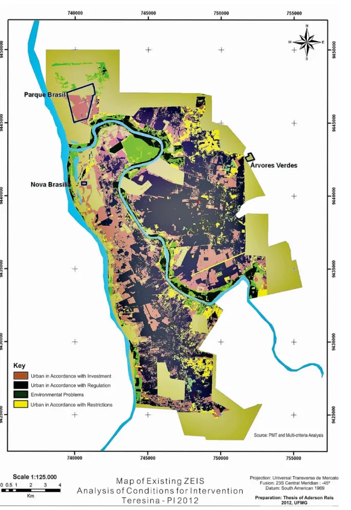
According to data from the Municipality of Teresina and the Oicial Gazette of the Municipa
-lity, there are three ZEIS, established in accordance with the City Statute: Nova Brasilia (created by Complementary Law No. 3690 of 10th October, 2007), Parque Brasil (created by Complementary Law No. 3755 of 17th April, 2008) and ZEIS Árvores Verdes (created by Complementary Law No. 3789 of 18th July, 2008).
However, what is questioned here is that the boundaries of these small areas in the munici
-pality fall short of the need to deine urban areas destined for social interest housing. It is evident that the three deined areas are outlined as territories recognized as housing programs, but many areas that show the need for urban renewal, land regularization or are suitable for new occupations
were dropped.
This study aims to identify new areas so the deinition of areas of social interest is a more realistic picture of Teresina’s reality. It was noted that in order to minimally meet the principles of the City Statute, Teresina’s Master Plan delimited three ZEIS that fall far short of the existing needs and reality as there are many areas with the appropriate features to become ZEIS. Thus, the spatial analysis proposed herein has three goals, the irst of which is to examine the conditions of the three ZEIS already deined in terms of these territories’ suitability regarding possible conlicts
with environmental interests and the conditions for urban settlement. Using a map that better re
-lects the reality of the existence of vilas and favelas in Teresina, the second objective is to evaluate the adequacy of each of these areas in terms of possible conlicts of interest with environmental preservation and to determine the suitability of their territories for urban use. This analysis acts as a base to support decisions on how to proceed with each unit. Finally, the third objective is to present synthesized maps, the irst shows the need for environmental preservation in Teresina, the second showing potential occupation and urban expansion, and a third which is the combination of the irst two and identiies areas of conlict of interest in the occupation of Teresina, in order to identify possible areas for the installation of new occupations of social interest.
METHODOLOGY
The technique of combining variables for multi-criteria analysis employs several methods. One of the methods used in Multi-criteria Analysis is the Weighted Linear Combination (CLP) (VOOGD, 1983). With the CLP, the factors are combined by assigning a weight to each of them, followed by adding the results to produce an adaptation map according to the following expression:
S = Σ wi.xi (1)
This procedure is common in GIS and is very similar to a regression equation. In cases where Boolean constraints are applied, the procedure is modiied by multiplying the calculated adjustment from factors from the product of restrictions. All GIS software has the basic routines for the use of this method. The basic question, however, lies in the standardization of the scores of the criteria and assigning weights.
Once the structure of the cartographic collection has been deined with the variables, they are combined with matrix algebra through the weighted average, which attributes weights for each
-71 ic knowledge of the territory in question. In this case, we chose the formulation of the weighted
average proposed by Xavier da Silva (2001) and Moura (2005) in the environmental assessments, which adopts the classiier algorithm represented by the following expression:
(2)
This expression allows the following reading: n - Number of parameters (maps or PIs) used;
Aij - Probability of occurrence of the event analyzed in the element (pixel) I, j of the resulting (map) matrix;
Pk - Weight assigned to “k”, in relation to the others, for the occurrence of the event being analyzed;
Nk - Score assigned to the category or class of parameter .
This procedure necessarily involves assigning of weights and scores to the diferent levels and categories of information involved, according to the level of signiicance in relation to the situation analyzed, so that the sum of the weights can not exceed 100%.
From this formulation of the Environmental Analysis, the following propositions can be made, also according to Xavier da Silva (2001):
. Aij - Expresses the resulting probability of the product of the environmental formulation on a scale of 0 to 10, for the occurrence of an event or environmental organization that is caused, in principle, by the convergent action of the environmental parameters it considers;
. The data involved in the evaluation can be placed on an ordinal scale that ranges between 0 and 10 or between 0 and 100, so that an amplitude variation suicient to allow a greater perception of the variability of the estimates is generated;
. The standardization of weights, restricted between the values 0 and 1, results in a deinition of the weight value assigned to a map as the maximum amount that any of the classes that map can take. For example, assigning a 40% weight to the parameter “slope” in an analysis means that the maximum that a particular class on this map can contribute to the determination of the probability of occurrence of the event is 4, on a scale of 0 to 10.
. With the adoption of the weighted average a classiication space is created that, is ordinal in principle, but allows large and varied detail in the classiication of estimates.
72
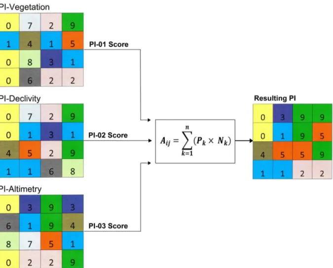
Figure 1 - Illustration of the process of crossing the IP in the form of matrices with assigned weights and scores, the scores are the values contained in each cell according to the key, and the weights are attributed by information plan
(in the example: vegetation, declivity and altimetry). Source: Adapted from Nunes (2009).
Once the layers are combined, the result is a potential surface, with results by the territorial unit of integration (or pixel) that the research set out to accomplish. The value obtained for each pixel of the resulting matrix signiies the extent to which each position is adequate or not (with a value of 0 to 10, with 0 being the least suitable) for the objective of the analysis.
ANALYSIS FOR THE IDENTIFICATION OF CONFLICTING INTERESTS
Prior to the speciic study to deine the ZEIS areas a general examination of the urban territory was carried out to identify those areas most suitable for occupation and urban expansion, while also identifying the areas of greatest value for environmental preservation. Once these two portraits of urban reality had been created, they were compared in order to identify conlicts of interest between urban use and environmental protection.
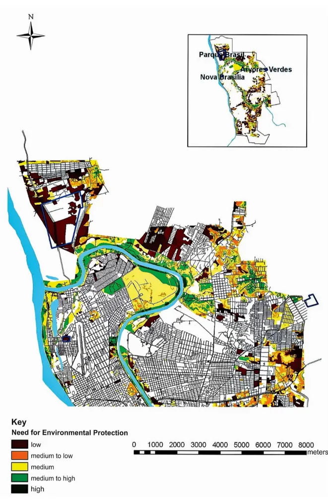
To produce the maps of Synthesis of Environmental Interest and Synthesis of Interest for Urban Expansion, variables were selected that indicated the interest of each theme, mapped in the form of Thematic Maps, structured in the form of matrices or potential surfaces in the distribution of the phenomenon, according to the relevance of each variable and each synthesis.
73
74
present are located in areas of low environmental interest; in this context, no conlicts have been conigured.
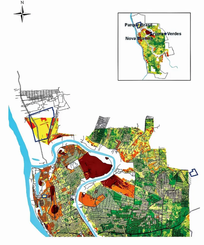
The Synthesis of Interest for Expansion and Urban Occupation was created by combining data on the presence of infrastructure and impediments to urban occupation, such as vegetation and protected areas, urban geotechnics, altimetry, declivity, lood areas, accessibility and capillarity identiied by the presence and type of urban roads, and the existence of infrastructure represented by electricity, garbage collection, sewage and water network. Once the synthesis was constructed,
the suitability of the three current areas delimited as ZEIS was veriied to gauge the level of inte
-rest of urban expansion and occupation (Figure 3). It was observed is that the current ZEIS are in areas of medium or medium-low potential for urban expansion and occupation, which will require signiicant investments for correction and adjustment.
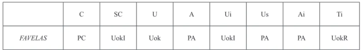
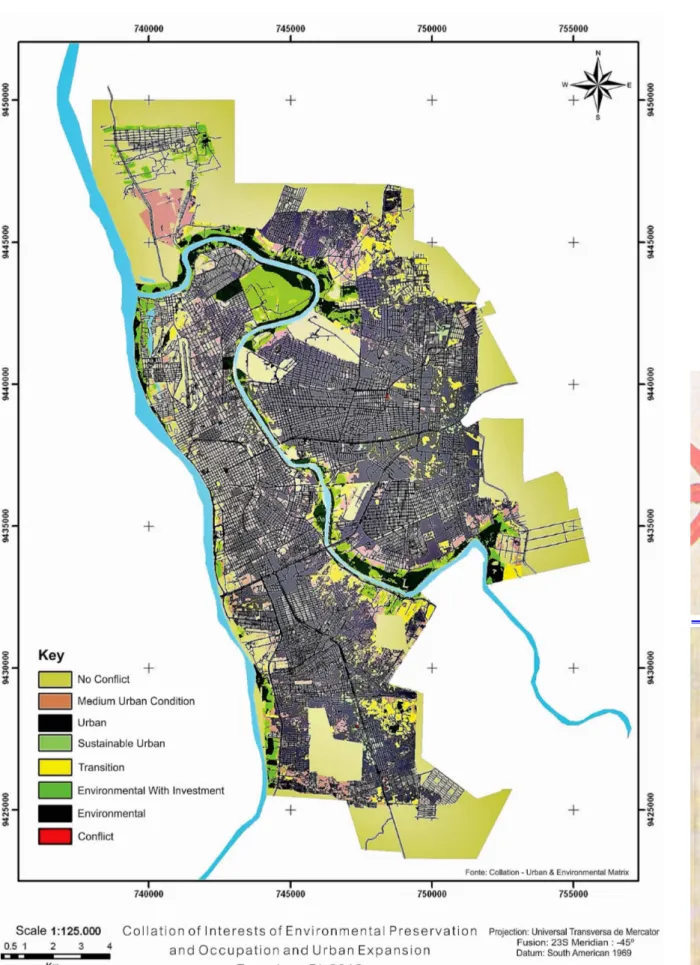
With the two aforementioned syntheses in hand (details of which can be obtained in Reis Filho, 2012), they were collated in the matrix of conlicting interests (Table 1). The matrix identiied, for example, that a high or medium-high environmental interest combined with a high or medium-high urban interest indicates a conlict of interest. On the other hand, a low environmental interest with a high urban interest already relects the predominance of urban interest, and so on.
The combination of classes identiied are: C - Conlict, U - Urban Interest, A - Environmental Interest, SC - No Conlict, Us - For Sustainable Urban Use, Ui - For Urban Interest but in need of Investment, Ai - For environmental interest but requiring investments, Ac - for Environmental Interest but with caution as there is risk of land invasion. The mapping of the results is displayed in the Matrix of Conlicting Interests and on the specialized map (Figure 4 and Figure 5).
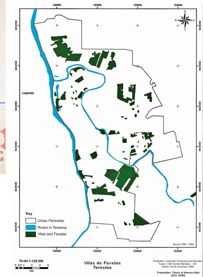
Once the combination of interests had been mapped, they were compared with existing vila and favela areas in Teresina. A map of the municipality’s vilas and favelas was obtained from the
Municipal City Hall of Teresina, through PRODATER (Department of Planning and Superinten
-dence of Rural Development) (Figure 6).
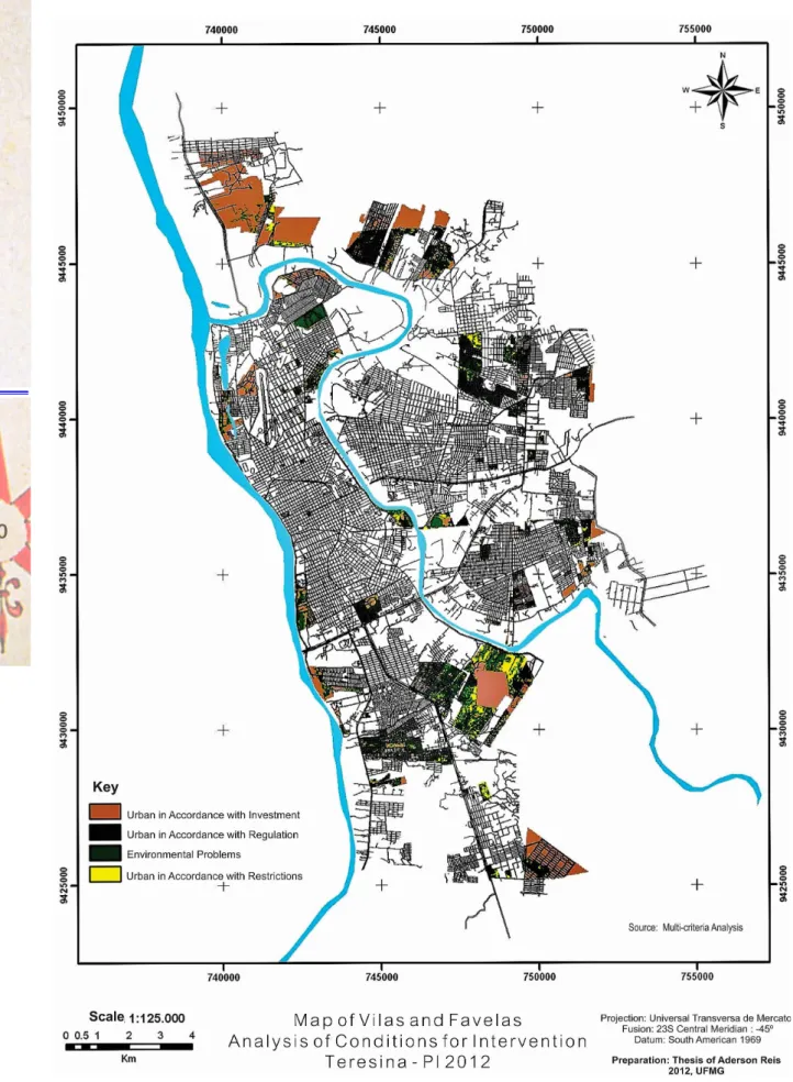
The comparison between the location of the vilas and favelas and the conlict of interest in the municipality (table 1) identiied the areas in which these occupations were in accordance with the
conditions and vocation of the location, areas where they agreed but needed requaliication invest
-ments, areas where they were in accordance with urban conditions but needed regularization, areas of some environmental interest where occupation should be planned to take place in a sustainable way, and problem areas because they are located in areas of environmental interest. (Figure 7 and Figure 8).
The following combination of types were identiied:
Table 1 - Combination matrix to identify Environmental and Urban Interests
C - Conlict: in areas of conlict of interest because there is interest in urban expansion, but also the need for environmental preservation, or areas of conlict that are of signiicant environmental interest. In such cases it would not be suitable to maintain the occupation, and speciic projects should be designed to address the problem. On the map the name is “Environmental Problems”. UI - Urban with Investments: areas that pose no conlict of interest and which may receive the ZEIS but have poor infrastructure, which needs to be addressed so that the occupation becomes suitable. On the map the name is “Urban in accordance but With Investments”.
75
76
Figure 4 - Matrix of conlicting interests. Source: Moura, 2003. Table 1 - Matrix of Conlicting Interests
C SC U A Ui Us Ai Ti
77
78
79
80
81 areas which, if positively transformed by well-made projects can have signiicant impact on
the urban landscape and land use in Teresina. On the map the name is “Urban in Accordance but With Regulation”.
FINAL CONSIDERATIONS
It is possible to observe various combinations ranging from conlict areas to favorable areas, that is, urban areas without conlict in the regions of vilas and favelas that are suitable for inter
-vention to promote regularization. It is important to note that the conditions found in the resulting map for urban interventions beneit managers regarding the applicability of the instruments of the City Statute.
It was observed that the areas characterized as “environmental problems” and “Urban with res
-trictions” represent insigniicant territorial extensions. The areas characterized as “Urban according to regulation” and “Urban according to investment” represent a signiicant territory, demonstrating unequivocally the possibility of the City Statute being employed to promote land regularization. The conditions of each of these in their intervention contexts act to support decision making.
Similarly, an analysis of the ZEIS was carried out to identify conditions for interventions. In this case, the most representative area, located in the ZEIS Parque Brasil, meets the condition “Urban according to investments”. One result was the vast range of the category “according to regulation” that incontestably supports the use of the City Statute in promoting interventions for regularization.
A link has been established between the City Statute, through one of its valuable land regu
-larization instruments known as the ZEIS and geoprocessing. This highlights the importance of technology as an analytical tool to support urban management, demonstrating the importance of combined analysis as a means of diagnosing existing conditions and identifying potential areas to deine new regions intended for social interest occupation.
Considering the ZEIS pertaining to Residential Zones 1 and 2 as potential urban territory for popular use (Article 24 of Law 3.560/2006), it is possible to select areas suitable for this use in a signiicant portion of Teresina, covering more than 60% of the urban area. In other words, it can be said that approximately 60% of the urban area may be designated to this purpose, in terms of the infrastructure, access, and geotechnics and the absence of conlicts with environmental interests.
Of the three ZEIS already deined in the municipal Master Plan, two (Parque Brasil and Árvores Verdes) are far from the urban center. Therefore, in this context, the authorities should direct more attention and public policies accordingly, as the City Statute provides instruments to promote the social functions of the city and the Master Plan has the power to establish better land use.
The irst contribution of this work is, of course, the speciic collaboration with Teresina, which can immediately use the results to review their plans and instruments to deine areas for housing and projects of social interest. Through these analyzes, which have reproducible and defensible criteria, one can argue about the identiication of the areas with respect to the potential, limitations and conditions for the allocation of popular programs or urban expansion programs.
However, in addition to the aforementioned speciic contribution, the main product of this work is the methodological approach that can be implemented in other municipalities. To mirror the methodology employed in other areas a minimum data set is required, which is quite possible on the scale of Brazil. The minimum and accessible variables to analyze environmental themes and urban expansion are considered to be those that best represent the speciic characteristics of the area in question.
To characterize environmental variables, the basis would be:
82
multi-criteria for the potential urban occupation can be given by mappings using media for visualizing medium resolution images. We had the privilege of working with high-resolution images, but visual inspection of territorial occurrences and mapping by block would also be
acceptable.
. Mapping of vegetation cover. This must be performed by RapidEye standard images, which in addition to the 5 meter pixel also has the RedEdge range (690-730 mm) and near infrared (760-850 mm) that can identify changes in chlorophyll levels and the cellular structure of plants. Because of these characteristics, a RapidEye image is suitable to separate vegetation from other land uses and to classify diferent conditions of vegetation cover. This favors mapping the robustness of the vegetation, which is important for urban planning. For urban planning the value of mapping the type of vegetation cover is secondary, since most species in the urban area are exotic, but the volume (trees, undergrowth) is essential. Rapid-eye images are now provided by the Ministry of Environment (Geocatálogo) upon the authorization of a request for institutional or academic use.
. Mapping altimetry and declivity. In this particular case study, the city already had a good vectorial topographic base. However, in the absence of better data, it is possible to work with medium-quality data, with contour lines interpolated equidistantly by 15 meters, resulting from free-access Aster DEM satellite data. The user must take the appropriate care when handling errors (spurious pixels), but the average quality meets planning purposes in the expected range for an expeditious deinition of strategic areas for occupation. Better detailing can be performed retrospectively, once the priority areas have been deined, and then surveys could be contracted for a project with a more executive character. This data source generates both altimetry and declivity maps.
. Protected Areas. These have to use institutional data, which should be provided, even if in analog form, by the public sector. However, if the area has legal protection the perimeter of the listing will be deined, so it would be quite possible, at the municipal level, to draw those
boundaries. There are states that already ofer platforms with free access to digital maps con
-taining the polygons of preservation areas.
. The lood areas. This layer of information was very speciic in the case of Teresina, as it is an important component for local planning due to the circumstances of the location. This preparation can be done by studying the digital elevation model and the identiication of the lood quota with the support of ield work, calibrated by consultations with public oicials and the public about the memory of prior incidences. It is of signiicance, however, that in other municipalities other speciic variables may be of greater interest.
To characterize variables of the condition of urban expansion , the basis would be:
. Urban Geotechnics. This variable is not often present in urban mappings. However, there are already eforts by the Ministry of Cities in the discussion of the national spatial planning policy, Law 12608 of 2012, establishing the National Policy on Protection and Civil Defense that foresees the need to prepare maps to identify areas that are vulnerable to hazardous events. Thus, in the medium term municipalities need to join eforts to develop this variable.
. Accessibility and capillarity. It is a fairly simple variable to determine as the municipality only needs a vector layer for roads, separated into type of public place. In general, it would be enough to separate roads or highways, avenues and streets, and if possible identify alleys. Once this is done, it is a model of concentration of streets that weighs their hierarchies accor
83 . Infrastructure for electricity, garbage collection, sewerage and water mains. Mapped from
census returns and a database developed from the10-year census. These data are freely availa
-ble in vector iles and ta-bles that can be attached to sectors using their univocal identiication codes. This is possible for any Brazilian city.
. The variables that would hinder growth due to declivity and vegetation cover follow the same logic as the layers designed for environmental studies.
To complete the methodology there is still the need to map the areas of vilas and favelas in the
municipality, which can be done even if the authorities only provide analog products to the resear
-cher. The recognition and the location of existing vilas and favelas is a requirement of the Master Plan. More than that: the City Statute states that the Master Plan must specify the ZEIS areas, with three conditions: those that identify and recognize the existing vilas and favelas, those that identify and recognize housing estates and those areas intended for future social housing projects.
Thus, in view of the above, the present methodology is accessible and replicable in other Bra
-zilian urban realities. ArcGis commercial software was used, which was available at the university where the research was conducted, but the same process of preparation of layers of variables and use of map algebra could have been done using free software, also readily available. Thus the work fulils the mission of the public university to promote discussions on methodological processes that can be employed by society for the common good.
ACKNOWLEDGEMENTS
This study is the result of the Doctoral Thesis developed at the Institute of Geosciences of the Federal University if Minas Gerais - UFMG, with support from the DINTER program Federal University do Piauí - UFPI / UFMG. The structure of this article is a contribution to the PROEXT
2013 program “Territorial Multipurpose Cadastre in the Meso West of Minas Gerais and Metro
-politan Belo Horizonte,” UFMG in partnership with the Ministry of Cities, in order to collaborate with the discussions on the applications of GIS in municipal planning and management, especially for the application of principles of the City Statute.
BIBLIOGRAPHIC REFERENCE
AFONSO, Alcília.; VELOSO, Samara. Habitação de interesse social em Teresina: algumas relexões.
Teresina: EDUFPI, 2012.
AGENDA 21 Brasileira: resultado da consulta nacional / Comissão de Políticas de Desenvolvimento Sus
-tentável e da Agenda 21 Nacional. 2. ed. Brasília: Ministério do Meio Ambiente: Brasília, 2004.
BRASIL. Lei Federal nº 10.257. 10 de jul. de 2001. Regulamenta os Arts. 182 e 183 da Constituição Federal,
estabelece diretrizes gerais da política urbana e dá outras providências.
BRASIL, Estatuto da Cidade - guia para implementação pelos municípios e cidadãos: Lei Nº 10.257, de
10 de julho de 2001, que estabelece diretrizes gerais da política urbana. ROLNIK, Raquel (coord). 3. ed. Brasilia: CEF / Pólis, 2005.
BRASIL. Plano Diretor Participativo. Guia para a Elaboração pelos Municípios e Cidadãos, Ministério das Cidades, 2004.
LIMA, Antônia Jesuíta de. Gestão Local e Políticas Urbanas: uma experiência de urbanização de favelas
em uma capital nordestina no Brasil, VI CONGRESSO PORTUGUES DE SOCIOLOGIA, Série 514.
Lisboa. 2008.
MARICATO, Ermínia. Brasil, cidades: alternativas para a crise urbana. Rio de Janeiro: Vozes. 2001.
MOURA, Ana Clara M. Geoprocessamento na gestão e planejamento urbano. 2a. ed. Belo Horizonte:
84
NUNES, Paulo. Conceito de árvore de decisão. 2009. Disponível em: <http://www.knoow.net/cienceco
-nempr/gestao/arvore_de_decisao.htm>. Acesso em: 20 jan. 2012.
REIS FILHO, A. Aderson dos. Análise integrada por geoprocessamento da expansão urbana de Teresi-na com base no Estatuto da Cidade: estudo de potencialidades, restrições e conlitos de interesses. (Tese
Doutorado), Universidade Federal de Minas Gerais, Instituto de Geociências. Belo Horizonte, 2012. TERESINA. Vila-Bairro. Teresina, PMT. 1997.
TERESINA. Secretaria Municipal do Trabalho e de Assistência Social. Censo das vilas e favelas de Te-resina, Teresina, PMT. 1996.
TERESINA. Lei nº 3.560, de 20 de outubro de 2006. Deine as diretrizes para uso do solo urbano do Mu
-nicípio de Teresina e dá outras providências. 2006.
VOOGD, H. Multicriteria evaluation for urban and regional planning. London: Pion, 1983. 370 p.
XAVIER-DA-SILVA, Geoprocessamento para análise ambiental. Ed. do Autor, Rio de Janeiro, 2001.
Submitted april 2016