Air temperatures in Central Amazonia
The effect of nearsurface temperatures on landuse in the Tertiary region of Central
Amazonia
W . L . F . BRINKMANN M . N . GOES RIBEIRO
Instituto Nacional de Pesquisas da Amazonia
ABSTRACT
M a x i m u m and minimum air temperatures were taken weekley at 10 different sites about 2 cm above ground level during the period of June 15th. 1968 to January 26th, 1970. Three temperature types were observed each of which has a specific ecological effect on land-use in Central Amazonia.
INTRODUCTION
A i r temperatures near the ground have a profound effect on biosphere and pedosphere. To a certain extent, they also influence the variety and abundance of photosynthetic and non photosynthetic microorganisms of the a i r s o i l boundary layer, and the chemical and biological dynamics of the decomposition of organic matter in the forests.
They hold a key position in the control of plant g r o w t h , as far as seedlings are concerned especially on cleared and naturally open areas such as : campinas, etc. It is already known, that various tree species in the early state of g r o w t h have a specific heat tolerance range, so near ground temperatures partly control the natural forest regeneration on cleared areas.
MATERIAL AND METHODS
M a x i m u m and m i n i m u m air temperatures w e r e read weekly at 10 d i f f e r e n t sites at about
2 cm above ground. These measurements w e r e taken the t i m e f r o m June 15 t h , 1968 to January 26 t h , 1970. Maximum and m i n i m u m temperatures w e r e recorded by the common mercuryfilled thermometer w i t h a support and protected against direct radiation input by
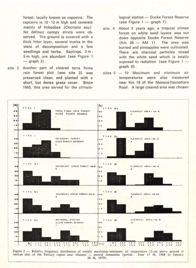
forest, locally known as capoeira. The capoeira is 1 0 1 2 m high and consists
mainly of Imbaubas [Cecropia spp) No defined canopy strata were ob served. The ground is covered w i t h a thick litter layer, several trunks in the
state of decomposition and a f e w seedlings and herbs. Saplings, 3 m 5 m high, are abundant (see Figure 1 — graph 2).
s i t e . 3 Another part of cleared terra f i r m e rain f o r e s t plot (see s i t e 2) was preserved clean, and planted w i t h a short, but dense grass cover. Since 1965, t h i s area served for the climato
logical station — Ducke Forest Reserve (see Figure 1 — graph 7 ) .
s i t e . 4 About 5 years ago, a tropical climax forest on w h i t e sand layers w a s cut down opposite Ducke Forest Reserve
(Km 26 — A M 1 ) . The area was burned and pineapples were cultivated. There are charcoal particles mixed w i t h the w h i t e sand w h i c h is totally exposed to radiation, (see Figure 1 — graph 9 ) .
sites 5 — 10 M a x i m u m and m i n i m u m air temperatures were also measured near Km 18 of the Manausltacoatiara Road. A large cleared area was chosen
T Y p t r
T Y P E ZZ C
TY PE nt
T E R R A F I R M E R A I N F O R E S T O U C K E F O R E S T R E S E R V E
S E C O N O A R Y F O R E S T O U C K E F O R E S T R E S E R V E
S E C O M 0 A R Y S H R U B F O R E S T / Mm IS 5
S E C O N O A R Y S H R U B F O R E S T / K m I 8
U E T E O R O L S T A T I O N O U C K E F O R E S T R E S E R V E
1
C L E A R C U T A R E A / K m I B
T Y P E H o
C L E AR C U T A R E A / Km I B
T Y P E TJJ 4 0
3 0 I 0 I 0
C L E A R C U T A R E A / K m > • a
T YP E m
C L E A R C U T A R E A , 1 0
Figure I — Relative frequency distribution of weekly maximum/minimum air temperature (2 cm above ground at various sites of the Tertiary region near Manaus — central Amazonia (period : June 15 th, 1968 to January
for the c l i m a t o l ó g i c a ! s u r v e y . About 4 years earlier, the natural climax forest on poor w h i t e sands was slashed and burned. There was some pineapple c u l t i v a t i o n , but the agri cultural effort f a i l e d . Two years ago, coco palms w e r e p l a n t e d . The plan tation produces e x t r e m e l y p o o r l y . Today, the hill slope is covered completely w i t h a secondary forest, w h i c h is dominated by 2 m to 4 m high Imbaubas [Cecrcpia spp) and Jurubébas [Solatium s p . ) . Soils w e r e classified as deep w h i t e sand layers somewhat similar to giant podzols, described for a nearby area (Klinge,
1965) . The surface layer is im pregnated w i t h charcoal particles as a result of the previous burning.
sites 5 and 6 M a x i m u m and m i n i m u m ther m o m e t e r s w e r e set up in the secondary f o r e s t on a hilltop (Figure 1 — graph 6) and at the bottom of the valley (Fi gure 1 — graph 5) • The sites have similar vegetation cover and vegetation density, but they d i f f e r in exposure to radiation. The valley site received direct solar radiation until 5 o'clock pm, w h i l e the hill top site was exposed to radiation about 12 hours a day.
sites 7 and 8 M a x i m u m and m i n i m u m ther mometers w e r e set up at approxi mately the middle of the slope. The site was exposed about 12 hours a day t o d i r e c t solar r a d i a t i o n . Site 7 (Figure 1 — graph 3) was installed on a small plot of w h i t e sand w i t h o u t any vegetation present, and site 8 (Fi gure 1 — graph 4) had a sparse grass cover.
sites 9 and 10 Maximum and m i n i m u m ther m o m e t e r s were set up on large vege tation — free w h i t e sand plots on the hill — top (Figure i — graph 10) and at the bottom of the valley (Figure 1 — graph 8) . The sites had similar s o i l , and both lacked vegetation cover, but they d i f f e r e d in exposure to direct solar radiation as mentioned above for sites 5 and 6.
RESULTS
When the data f r o m all ten sites were collected the maximum and m i n i m u m air tem perature readings revealed that the sites could be grouped according to their exposure to direct solar radiation and their vegetation cover.
A c c o r d i n g to maximum and m i n i m u m ait temperatures near the ground, three tempera ture types w e r e i n d i c a t e d . The temperature types w e r e as f o l l o w s :
Type I — The one peak type (Figure 1 — graphs 1 and 2 ) .
The m a x i m u m and m i n i m u m tem perature readings obtained must be considered n o r m a l ' for all sites, covered w i t h natural climax forest
( e x c e p t campinas) or d e n s e secondary f o r e s t . The temperature type is representative tor about 90 percent of the Tertiary region along the Manausltacoatiara Road and is independent of the type of s o i l .
Type II — The overlapping t w o peak type (Fi gure 1 — graphs 3, 4, 5, 6 and 7 ) . This t y p e has t o be s p l i t into t w o subtypes, because of the w e i g h t and position of the peaks.
Type II a. (Figure 1 — graphs 3 and 4 ) .
Type II b. (Figure 1 — graphs 5, 6 and 7 ) .
In general, both types report inter mediate air t e m p e r a t u r e conditions near the ground between type I and type I I I . W i t h respect t o tro pical agriculture, they demonstrate to better (type II b) and poorer (type II a) conditions.
Type III — The t w o peak type (Figure 1 — graphs 8, 9 and 10).
This m a x i m u m and m i n i m u m tem perature type must be considered l i m i t i n g to various s i l v i c u l t u r a l or agricultural a c t i v i t i e s .
CONCLUSIONS
primarily based on slash and burn. Not counting the unfavorable effects of this particular land use system on soil water balance, nutrient cycling, microbial life, etc., the nearsurface temperatures are affected as f o l l o w s :
Slash and burn applied :
I — 1) Reforestation on sandy soils (Podzols, Regosols}.
Nearsurface maximum and m i n i m u m air temperature distribution chain is : Type I (Figure 1 — graph 1) destroyed type III (Figure 1 — graphs 8, 9 and 10) type II a
(Figure 1 — graph 4 ) .
High near ground surface tempera tures are extremely harmful to the seedlings of a great variety of tropical tree species of economic value. Reforestation w i l l be affected by these high temperatures, as the
number of tropical tree species plan table is greatly reduced (selection) and a proportion of the seedlings w i l l be stunted or die, and have to be
replanted. Type II b (Figure 1 — graphs 6 and 7) is not desirable
(shadow e f f e c t ) , because the second ary g r o w t h , (especially Cecropia spp
and Solanum sp) w i l l raise serious
root c o m p e t i t i o n problems.
I — 2) Agriculture on sandy soils (Podzols, Regosols).
Nearsurface maximum and m i n i m u m air temperature distribution chain is :
Type I (Figure 1 — graph 1) destroyed type III (Figure 1 — graphs 8, 9 and 10).
High nearsurface temperatures are harmful to almost all vegetables and some other cultivated plants. Natural shadowing (type II b — Figure 1 — graphs 6 and 7) is not desirable,
because of serious root c o m p e t i o n . A r t i f i c i a l shadowing has to be applied,
i . e . the farmed plots are l i m i t e d t o a very m i n i m u m . The selective effect of nearsurface temperatures, as one factor out of many others, conditions monocultures of pineapple and ma nihoc.
I — 3) Cattle breeding on sandy soils (Pod zols, Regosols).
Nearsurface maximum and m i n i m u m air temperature distribution chain is :
Type I (Figure 1 — graph 1) destroyed type III (Figure 1 — graphs 8, 9 and 10) type II b (Figure 1 — graph 7 ) .
High nearsurface temperatures w i l l act selectively on grass species and native fodder plants. They are harmful in the early stages of g r o w t h . A dense grass cover w i l l not be obtained owing to other l i m i t i n g f a c t o r s . During dry periods, the sparse grass cover dries up and raises serious fodder problems.
Neithef reforestation, agricultural ef f o r t s nor cattle breeding can be
recommended for sandy s o i l s . These areas (about 5 6 percent of the Tertiary region) should be conserved,
in their natural state as only the natural forest cover supplies the best environmental conditions.
Slash and burn applied:
II — 1) Reforestation on latosols.
Nearsurface maximum and m i n i m u m air temperature d i s t r i b u t i o n chain is : Type I (Figure 1 — graph 1)
destroyed type III (Figure 1 — graphs 8, 9 and 10, but less extreme) _ type II b (Figure 1 — graphs 5 and 6) type I (Figure 1 — graph 2)
High nearsurface temperatures w i l l affect reforestation under type III — conditions. W h i l e other limiting factors (soil water balance, nutrients
available, etc.) are less pronounced, the situation is less serious. Never theless s i l v i c u l t u r a l efforts have to be r e s t r i c t e d to a f e w tropical tree species of economic value, when large scale reforestation schemes are considered.
II — 2) Agriculture on latosols.
Type I (Figure 1 — graph 1)
destroyed t y p e III (Figure 1 — graphs 8, 9 and 10, but less extreme) type II b (Figure 1 — graph 7 ) .
High nearsurface temperatures w i l l affect a l m o s t all vegetables and a series of other cultivated p l a n t s. As soil moisture p r o b l e m s , nutrient a v a i l a b i l i t y , etc. are less delicate, the variety of plantable crops is less r e s t r i c t e d but monocultures (peper plantations, etc.) are not desirable, because, of the potential dangers of plant diseases.
II — 3) Cattle breeding on latosols.
Nearsurface maximum and m i n i m u m air t e m p e r a t u r e d i s t r i b u t i o n chain is :
Type I (Figura 1 — graph 1) destroyed type III (Figure 1 — graphs 8, 9 and 10, but less extreme)
type II b (Figure 1 — graph 7 ) . As stated above, high nearsurface temperatures are harmful to grass species and fodder plants in the early state of g r o w t h , i . e . a negative selection of the w i d e variety of the available native fodder plants w i l l take p l a c e . During serious droughts, and for several months after the grass cover dries up as a result of direct solar radiation and water d e f i c i e n c y . Serious droughts in central Amazonia occur at roughly 3 5 year intervals, so they are bound to affect all long t e r m projects of cattle b r e e d i n g . Latosols are the representative soil t y p e for at least 85 percent of the Tertiary region along the Manaus Itacoatiara Road. Large scale re forestation and agricultural efforts
including cattle breeding cannot be recommended unconditionally on these soils, because of nearsurface temperatures, and many other l i m i t i n g
factors such as cycling plant nutrients (Brinkmann, W . L. F. and A . dos Santos, 1971 a, 1971 b; Stark, N . , 1971), nutrient leaching (Nascimen to, J . C . de and W . L. F. Brinkmann, 1972), soil water balance, etc.
It seems t o the authors, that the nearsurface m a x i m u m and m i n i m u m air t e m p e r a t u r e d i s t r i b u t i o n for an ideal agricultural or cattle breeding scheme should be in a position be t w e e n temperature conditions shown in Figure 1 — graph 2 and graph 6. Futhermore the f o l l o w i n g guide — lines are proposed w h e n large scale s i l v i c u l t u r a l or agricultural schemes are being planned :
1) A l l areas such as deep w h i t e sand areas (tropical podzol soils and regozols) w h i c h are known to be w o r t h l e s s for s i l v i c u l t u r a l or agri cultural large scale schemes, should be c o n s e r v e d, as the existing climax f o r e s t matches best these very tight e c o s y s t e m s .
2) Large scale slash and burn methods have to be avoided, because of their d e t r i m e n t a l effects on mezo — and m i c r o c l i m a t e , humus content, nitrogen and other plant nutrients present, and on the soil — w a t e r balance of the area.
The Laboratories of Environmental Sciences and the Center of Forestry Research of INPA, developed a joint scientific program to clarify the basic needs and preservation rules of sil vicultural and agricultural develop ment of t h e Tertiary region of central A m a z o n i a . The results w h i c h w i l l be available in the near f u t u r e , w i l l provide governmental a g e n c i e s ,
farmers and ranchers w i t h the data necessary for a better understanding of the ecodynamics of the Tertiary region, and consequently should lead to viser development schemes.
ACKNOWLEDGEMENT
R E S U M O
Temperaturas máximas e mínimas do ar foram medidas em dez locais diferentes na Amazônia Cen-tral, a u m a altura de 2 cm acima da superfície do solo. Como resultado destas medidas foram deter-minadas três tipos de temperatura, sendo que. cada um dos três tipos apresentam influências especificas para a agricultura, silvicultura e pecuária em rela-ção aos tipos de solos
Estas investigações foram realizadas em latosso-los e solatosso-los arenosos, visto que, esses dois tipos co-brem aproximadamente 90% dos solos da E s t r a l a Manaus - Itacoatiara.
Nos latossolos, os resultados obtidos demonstran: que sem considerar outros fatores limitantes, as quei-madas em grande escala prejudicam até certo ponto o desenvolvimento da agricultura, silvicultura e pe-cuária, havendo por isso mesmo urgentes
necessida-des de modificar o sistema de exploração.
Sem dúvida alguma, as áreas com areias bran cas, não podem ser utilizadas por longo prazo para agricultura, silvicultura e pecuária em grande escala
por sofrerem fortes influências da temperatura sem levar em consideração outros fatores limitantes.
Essas áreas no momento são usadas p a r a mono-culturas (mandioca e abacaxi) porém em futuro elas devem permanecer conservadas.
LITERATURE CITED
A L ' I I R É V I L L Ë , A .
1961 — Étude écologique Je principales formations végétales du Brésil. Nugent sur Marne. Centro Technique Forestier Tropical,
B R I N K M A N N , W . L . F. & SANTOS, A . uos
1971a — Natural waters in Amazonia. V — Soluble magnesium properties. Turrialba. 21(4) :95-101 1971b — Natural waters in Amazonia. VIT — Total
phosphorus compounds. Symposium Proceedings on Environment in Amazónia, Part III. Manaus.
(in press).
N A S C I M E N T O , J. C . DE & B R I N K M A N N , W . L . F.
1972 — The effect of slash and burn on soil chemistry in the Tertiary region of central Amazonia.
Acta Amazonica, Manaus 2(1) (in press).
STARK. N .
1971 — Nutrient cycling in South American rain forest.