RBRH, Porto Alegre, v. 21, n. 4, p. 674-684, out./dez. 2016 Scientiic/Technical Article
http://dx.doi.org/10.1590/2318-0331.011615153
Vertical hydraulic gradient research in hyporheic zone of Beberibe river in
Pernambuco State (Brazil)
Investigação do fluxo vertical da água na zona hiporreica num trecho do Rio Beberibe – PE
Tatiane Barbosa Veras1, Jaime Joaquim da Silva Pereira Cabral1, Anderson Luiz Ribeiro de Paiva1, Roberto Lima Barcellos1 and Laércio Leal dos Santos2
1Universidade Federal de Pernambuco, Recife, PE, Brazil
2Universidade Estadual da Paraíba, Campina Grande, PB, Brazil
E-mails: [email protected] (TBV), [email protected] (JJSPC), [email protected] (ALRP), [email protected] (RLB), [email protected] (LLS)
Received: October 05, 2015 - Revised: April 28, 2016 - Accepted: June 13, 2016
ABSTRACT
The interaction between groundwater and surface water occurs naturally and is dependent on the dynamics in the hyporheic zone.
The hyporheic zone is the interface between the surface water source and the phreatic aquifer and it’s a system that also inluences the water quality. An important feature is the ability to lux in this zone. This work aimed to evaluate the vertical hydraulic gradient in the hyporheic zone at two points in Beberibe river, Olinda-PE, to understand the hyporheic environment characteristics and water low dynamics in experimental area, in addition to identify the existence of hydraulic connection between surface water and groundwater. The experimental phase consisted of iniltration tests in riverbed with cylinder iniltrometer and vertical hydraulic gradients readings
with differential piezometer, complemented with grain size information, for an assessment of the water budget between the river and the aquifer. Analyzing the behavior of the interaction over the period of 10 months, it was observed that the Beberibe river
(middle course) contributes to the groundwater recharge in most of the time. The average iniltration rate was 1.02 mm/min in point 1 and 0.85 mm/min in point 2. It was concluded that there is a variability in low direction, which often is top-down, but may undergo
change in the stream showing upstream after long periods of rainfall. Another conclusion is that grain size distribution of bed sediment,
that is predominantly sandy, inluences hydraulic conductivity of hyporheic zone and inluences consequently the vertical low rates.
Keywords: River-aquifer interaction; Iniltration; Cylinder iniltrometer; Differential piezometer; Hyporheic zone.
RESUMO
A interação entre águas subterrânea e supericial ocorre naturalmente e depende da dinâmica na zona hiporreica. A zona hiporreica é a interface entre o corpo hídrico supericial e o meio subterrâneo, sendo um sistema que também inluencia a qualidade da água. Uma importante característica é a capacidade de luxo nesta zona. O trabalho objetivou avaliar o luxo vertical de água na zona hiporreica em dois pontos do rio Beberibe, Olinda - PE, para compreender as características do ambiente hiporreico e a dinâmica do luxo de água nesta zona, além de identiicar a existência de conexão hidráulica entre a água supericial e subterrânea. A fase experimental consistiu em ensaios de iniltração no leito com iniltrômetro de cilindro e leituras da diferença da carga hidráulica com piezômetro diferencial,
complementadas com informações granulométricas, para uma avaliação da capacidade de transporte de volumes hídricos entre o rio
e o aquífero. Analisando-se o comportamento da interação ao longo do período de 10 meses, veriicou-se que o rio Beberibe no seu curso médio contribui para a recarga do lençol freático em boa parte do tempo, sendo a média da taxa de iniltração de 1,02 mm/min no ponto 1 e de 0,85 mm/min no ponto 2. Concluiu-se que há uma variabilidade no sentido do luxo, que geralmente é de cima para baixo, mas pode sofrer alteração no luxo apresentando ascendência após longos períodos de chuva. Concluiu-se, ainda, que a distribuição granulométrica dos sedimentos do leito, que são predominantemente arenosos, inluencia a condutividade hidráulica da zona hiporreica e consequentemente as taxas de escoamento vertical.
INTRODUCTION
Groundwater and surface water interaction between rivers and streams is of great importance for both quantitative aspects of water and in environmental issues involving the whole food
chain. The subject is very complex and related to a number of
physical and biochemical factors, often requiring a multidisciplinary approach.
Surface water and groundwater resources are closely related and any work performed on one will ultimately affect the other (FEITOSA; MANOEL FILHO, 1997; ENVIRONMENTAL
AGENCY, 2009). Given the importance of this, there has been a worldwide increase in studies and policies regarding surface water and groundwater interaction. This is also true in Brazil.
According to Sophocleous (2002), there is a growing increase
in studies of vertical low in river-aquifer interactions. In recent
decades, many studies have focused on small-scale interactions between surface water and groundwater, also known as the hyporheic zone. This interface has become a very active research topic in many parts of the world (GENEREUX et al., 2008; LAUTZ;
KRANES; SIEGEL, 2009; BOANO; REVELLI; RIDOLFI, 2010; BIANCHIN; SMITH; BECKIE, 2011; LARNED; DATRY, 2013; ALBUQUERQUE et al., 2014; LENCIONI; SPITALE, 2015). This zone is considered a region of great physical, chemical and biological dynamics, a very heterogeneous and active place, requiring continuous assessment.
The hyporheic zone, which is a transition zone of a few centimeters between a river and an aquifer, forms a unique
dynamic ecosystem, which at the same time is inluenced by, but may signiicantly inluence, the low and quality of groundwater
(ENVIRONMENTAL AGENCY, 2009; LAWRENCE et al., 2013). Figure 1 shows an adaptation of a schematic diagram drawn up by the British Environmental Agency (ENVIRONMENTAL
AGENCY, 2009) with many details concerning the hydrological, hydraulic, geological, chemical and biological processes.
Given the signiicance of this zone, it is extremely important
to know its characteristics as one of the interaction zones of groundwater with surface water. This knowledge provides a way to understand these relations towards effective research on the vertical hydraulic gradient in the river-aquifer interaction.
The present report analyzes the vertical hydraulic gradient
in a hyporheic zone where a ield experiment has been carried
on in the Beberibe River, in the state of Pernambuco - state in the Northeast of Brazil. An assessment of the carrying capacity of water volume between the river and the aquifer was assessed
through iniltration tests and readings of water low performed in the riverbed in order to understand the vertical low of water
in hyporheic zone.
The hyporheic zone and the dynamic of vertical low
Many variables have been used to characterize the hyporheic zone, such as: ecological, morphological, chemical, hydrological, residence time and even combinations of these variables (WILLIAMS,
1989; BOULTON et al., 2010; GOOSEFF, 2010; BIANCHIN;
SMITH; BECKIE, 2011; LARNED; DATRY, 2013; LEHR et al., 2015). The selected focus can inluence the line of study, but the important thing is to understand that the hyporheic zone is a very dynamic environment, with an ecosystem responsible for a number of important reactions.
This report is made from the hydrological point of view,
using the deinition of Lewandowski et al. (2011) with the hyporheic zone as the saturated transition zone between surface water and groundwater, being a key terrestrial hydrosphere compartment.
A water low study in the hyporheic zone has signiicant
relevance as it may represent an opportunity to evaluate the effectiveness
of hyporheic zone in improving water quality or serve as a barrier against contamination of the aquifer (LAWRENCE et al., 2013).
The hyporheic low can be altered by a variety of human activities, including those that change the low or change the
riverbed or the underground (BOANO; REVELLI; RIDOLFI, 2010; MAIER; HOWARD, 2011). Certain rainfall events can affect
the surface water and have an inluence on the subsurface low. Rainfall can indirectly inluence the transverse variability of
the river-aquifer interface, generating river runoff and sediment transport, intensifying this interaction. Consequently, there can
be signiicant changes in surface or subsurface low. Furthermore,
precipitation events can generate the elevation of the aquifer levels
by inluencing the difference in hydraulic heads between the river
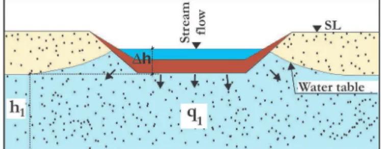
and the aquifer (Figure 2).
In Figure 2, the A condition can be seen, when the water table contributes a q1 low into the hydraulic section due to the
existence of a hydraulic head difference (Δh) between the aquifer
and the main channel. In the B condition, soon after the rainfall,
increased hydraulic head on the surface water is more signiicant
than the increase in the hydraulic head in the aquifer. This is because the contribution from runoff in the river channel is faster
than the contribution by iniltration into the aquifer. Thus, there
is a contribution of the hydraulic gradient, making q2 less than q1. After a few days of a rain event, as in condition C, the aquifer will have received a considerable volume of water, thus causing an increase in the hydraulic head. The mainstream section, no longer receiving the contribution of runoff, is fed by the water table, thus causing a hydraulic gradient higher than under the A
condition and therefore a greater low q3.
Generally, rivers are evaluated by their distinctive interactions:
inluent, when the surface water contributes to the subsurface low; or efluent, when the groundwater drains towards the river
(PAIVA, 2009). This water exchange occurs through the hyporheic
zone, where the low is constrained and compounds are dumped directly into the downstream low.
The water stream has its low not only supericially but also through the interstices of the sediment low channel and the riverbanks, thus creating a mixing zone between groundwater and
surface water (KOBIYAMA, 2003). These mixing zones are also
governed by the river level luctuations.
The deposition of sediment on the bed can minimize
hyporheic exchange (PACKMAN; MACKAY, 2003), since the
retention of ine particles here reduces the occurrence or size of
the pores that are formed in the soil that facilitate the process of interaction between surface and groundwater. This can cause
riverbed clogging by a colmatation layer that also is inluenced
by chemical and biological processes.
The deposit of particles on a porous riverbed in the middle
inluences the permeability and cohesion of the sediment, thus limiting the iniltration capacity to the upper zone of the interstices
(GOLDSCHNEIDER; HARALAMPIDES; MACQUARRIE, 2007; GUNKEL; HOFFMANN, 2009).
For this reason it is important to know the nature of the sediments involved in the system in view of the aspects of permeability and hydraulic conductivity that are essential
for a better understanding of the vertical low dynamics in the
river-aquifer interface.
MATERIALS AND METHODS
Characterization of the study site
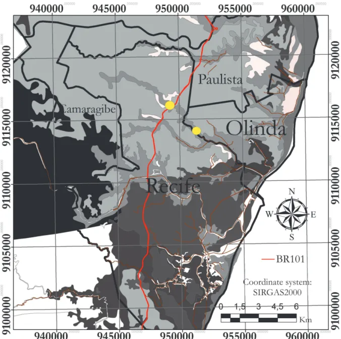
The research project area is located in the Metropolitan Region of Recife (RMR), on the border between the cities of Recife and Olinda, in the basin of the Beberibe river in its middle section (Figure 3).
According to the classiication of river basins in the state
of Pernambuco, the basin of the Beberibe river is part of Group 1 - GL1, which corresponds to the watershed group of small coastal rivers (APAC, 2014).
This group is located mainly on sedimentary rocks in the
Pernambuco-Paraíba basin, where there are extensive tertiary
deposits. Moreover, there are some quaternary formations created by alluvium and beach sediments.
From a meteorological point of view, according to APAC (2014), the average value of the cumulative annual total rainfall in the catchment area of the Beberibe river from 2003 to 2013 was
about 2202.9 mm/year. This amount of rainfall is considered high,
compared with other regions of northeastern Brazil.
In the region upstream from the BR-101 highway, one can easily observe the presence of local vegetation; downstream from the BR-101 highway, urbanization has taken over the basin of the Beberibe river, where currently there is only a small bit of native vegetation.
The catchment area of the Beberibe river today has a
population that approaches the 590,000 mark, with the inhabitants Figure 2. Aquifer interaction variability according to rainy season,
situations: (A) early rain; (B) after the rain; (C) a few days later,
spread over its small area, making it into a predominantly urban and densely populated area, with about 7,300 inhabitants/km2 (PERNAMBUCO, 2012).
No doubt, the Beberibe river is one of the most polluted rivers in the state of Pernambuco. In fact, informal settlements located near the slopes bordering the river have further ill-treated it.
Two points along the Beberibe River were chosen to estimate the vertical hydraulic gradient in the river-aquifer interaction (Figure 4).
Point 1 is located downstream from the BR-101 Highway, where the Beberibe river is approximately 6 m wide. There, the river lows through an urban area consequently suffering domestic
pollution. The water depth varies from 0.30 to 0.40 m in dry and wet periods, respectively.
Point 2 is upstream from the BR-101 Highway, where
the area is well preserved, with clear waters and no urbanization. At this point the Beberibe river has an average width of about 7 m and a water depth ranging from 0.20 to 0.25 m.
At selected points, iniltration tests were carried out to
get data on the vertical hydraulic gradient and collect samples for particle size tests.
Grain size distribution
The river-aquifer interaction process can be greatly inluenced
by the characteristics of the soil that make up the hyporheic zone because, depending on material found, the hydraulic conductivity sediment may be affected.
Towards understanding this, tests were performed to determine grain size distribution towards identifying the material that makes up the hyporheic zone analyzed stretch.
In November 2014, samples were collected for the grain size distribution test. It can be understood that these results were representative of the time intervals of the other observations of the study. In the study, at points (PT1 and PT2), samples from the hyporheic area were collected: 0-5 cm (1 sample for each point) and 5-10 cm (1 sample for each point). The samples are referred to as PT1 (0-5), PT1 (5-10), PT2 (0-5), and PT2 (5-10), total of 4 samples. The samples were collected with a sampler
corer. All of the samples were taken from the riverbed axis and
soon after collection were refrigerated for conservation.
Particle size analysis of the hyporheic sediments was processed at the Federal University of Pernambuco (UFPE) in the Geological Oceanography Laboratory (LABOGEO). The particle size distribution of the samples was determined by sieving and pipetting, as described by Suguio (1973) and ABNT (1984).
From the results obtained, the data of granulometric fractions were plotted on SYSGRAN version 3.0 software (CAMARGO,
2006), to determine the statistical parameters of the average diameter and the degree of selection, according to Folk and Ward
(1957) equations and the triangular diagram from Shepard (1954). From the results it is possible to better understand the vertical hydraulic gradient behavior in hyporheic zone.
Iniltration tests
The iniltration quantiication tests were performed every
two weeks for 10 months from February to November 2014, allowing for a proper assessment of the vertical hydraulic gradient in hyporheic zone, since the tests were only carried out in the main channel of the riverbed.
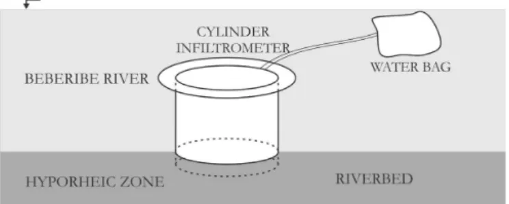
To perform the iniltration tests, cylinder iniltrometers
produced in acrylic were used, each cylinder with an area of 50.265 cm2 and height 19.4 cm. Bags for water (hospital plastic bags) with a capacity of 2 liters were also used.
formed a column of sediment inside, thus stabilizing it in the underwater bed. Then between the instrument and the hyporheic
sediment we applied a mixture of bentonite and water at a ratio of 1:1 along the external wall of the cylinder and the riverbed. Bentonite expands when it comes into contact with liquid and
acts as a sealant, preventing water entry or leakage along the periphery of the cylinder.
After the instruments were in place, the plastic bags, illed
with water, were weighed on an electronic scale and attached to the cylinder. They were put into the river under local environmental conditions such as temperature of the river, possible currents, water depth and the same hydraulic load (Figure 5).
After 20 minutes, the water bag was removed from the river and reweighed. The time of 20 min was determined by the research team, after several observations, to be enough to base the calculations on. At each point, there was the duplication of
tests to conirm the results.
Based on this methodology, we sought to calculate the
water iniltration rate in the bed by Equation 1:
.
t V I
t A
= (1)
where: It = iniltration rate [mm/min]; V = volume of iniltration
[mm3]; t = time [min]; A = cylinder area [mm2].
To improve accuracy, the amount of water from the water bag was measured in grams and the value subsequently transformed into mm3. for the calculation base, through its density, temperature of 25 °C was adopted, which was the average temperature measured
at the site during periods of tests, with water density of 997 kg/m3 at that local ambient temperature.
To obtain data on weather conditions on the days of the tests and the previous days, rainfall data was collected from the
nearest station to the research area (station 209 - Alto da Bondade) provided by Pernambuco Water and Climate Agency (Agência
Pernambucana de Águas e Clima – APAC).
Hydraulic head reading
To read the vertical water low in the Beberibe river, an
instrument was developed at the federal university of Pernambuco - UFPE. The device, called a differential piezometer, has as its basic principle the use of a graduated scale (cm) to measure differences between the river water level and the hydraulic head of the riverbed.
The differential piezometer is simple to handle and easy to interpret. It is composed of two metal rods 1 meter high each. Inside each, there is a transparent plastic tube, which facilitates the determination of the water level by eye. The bottom of the
device has a perforated 35 cm ilter tip, to facilitate soil drainage.
The tube is inserted here and passes the entire length of the rod. At the test points, the device is pressed vertically into the
bed to a depth of approximately 45 cm. When it is set into the
hyporheic zone, the differential piezometer passes through the surface layer of the bed, where the water enters the tube, which enables a reading of the level (Figure 6).
Three possible conditions can be read from the difference between the stream surface water level and the water level in the
device: if the river water level is below the water level checked in the tube, it means that the river is being fed by the aquifer at the reading point (Figure 6A - uplow (+)); if the river level is above the water level displayed in the tube, it is possible to conclude that the river is feeding the aquifer (Figure 6B - downstream (-)); there is the possibility that the water in the tube and the river surface water are at the same level, featuring a point where there is no vertical hydraulic gradient (Figure 6C - no low (0)).
We observed that 30 minutes was enough for the system to reach equilibrium, given the problem of agitation during the placement of the device into hyporheic zone. After that time,
the reading vertical low of the river could be carried out with
greater certainty.
RESULTS AND DISCUSSION
Grain size distribution
The results of particle size variation in the samples collected from the hyporheic zone of the two points studied in the Beberibe river, are shown on Table 1, together with the other parameters discussed in this study (mean diameter and degree of selection).
Samples from Point 1 and Point 2 have a greater amount of sand in the composition, i.e. the studied stretch of Beberibe
river is predominantly sandy. However, there is heterogeneity in the diameters of the particles, ranging from coarse to ine sand.
The coarse sand fraction predominates in the hyporheic zone at Figure 5. Cylinder iniltrometer coupled to the water bag located in the river.
Figure 6. Interpretation of the differential piezometer under
Point 1, independent of the depth analyzed; while at Point 2, the
samples showed an enrichment of ine material in the deeper layer.
According to the data obtained, the degree of selection bias of particles in the Point 1 samples showed variation between moderate and poor. At Point 2, the samples showed no change in
their level of selection, thus being classiied as poor.
The particle size data gathered in the tests made with samples of sediments from the hyporheic zone were used for a better understanding of vertical hydraulic gradient behavior in hyporheic zone.
Iniltration test analysis
The results of iniltration tests are of fundamental importance for understanding the vertical low of the river in
the hyporheic zone.
Table 2 shows the results of infiltration rates at Point 1 and Point 2, the stretch of the Beberibe River under analysis, and a summary of the data used for the calculations.
The test showed that on April 10 there was the greatest
iniltration rate in the hyporheic zone at both points: Point 1
was 1.73 mm/min and Point 2, 1.28 mm/min. The least water
iniltration rate in the hyporheic zone at Point 1 took place on June 18 (0.27 mm/min). The least at Point 2 was 0.19 mm/min,
registered in the tests performed on March 12.
With respect to volume of water iniltration into the hyporheic zone: Point 1 had a variation of 146.9 cm3; and the variation at Point 2 was 108.8 cm3.
Considering that the speed of water iniltration in hyporheic
zone of the Beberibe River was the same in trials at both points, we can say that Point 1 had a slightly greater leakage than Point 2.
The averages rates of iniltration and variations in water volume iniltration show that during the period when the iniltration tests
were being carried out, there was a higher incidence of vertical hydraulic gradient in the hyporheic layer at Point 1 than at Point 2.
Similarly, Arantes, Chaudhry and Marcussi (2006) quantiied
the exchange rate between the river and the aquifer in the Ribeirão
da Onça basin, located in the municipality of Brotas – in the state
of São Paulo. They added, however, that the method (iniltrometer
Table 1. Particle size distribution analysis of samples from the bank and riverbed at two different depths in the studied points of the Beberibe river.
POINTS
PERCENTAGE (%) CLASSIFICATION
Gravel Sand Silt Clay Shepard
(1954) Average Diam. (ϕ)
Degree of selection (ϕ) PT1(0-5) 9.14 99.79 0.07 0 Sand 0.42 (coarse sand) 0.76 (moderate selection)
PT1(5-10) 16.27 83.59 0.14 0 Sand 0.44 (coarse sand) 2.05 (very poor selection)
PT2(0-5) 7.48 84.36 1.64 6.52 Sand 0.40 (coarse sand) 1.93 (poor selection)
PT2(5-10) 19.98 58.21 5.08 16.73 Sand 2.54 (ine sand) 3.81 (poor selection)
(ϕ) phi - negative logarithmic scale of base 2; Diam. - diameter.
Table 2. Iniltration test conducted in 2014 in hyporheic zone at the Beberibe river.
Date
POINT 1 POINT 2
Iniltration
mass (g)
Iniltration
volume (cm3)
Iniltration rate
(mm/min)
Iniltration
mass (g)
Iniltration
volume (cm3)
Iniltration rate
(mm/min)
11/FEB/2014 93.5 93.8 0.93 63.5 63.7 0.63
27/FEB/2014 156.0 156.5 1.56 107.5 107.8 1.07
12/MAR/2014 74.0 74.2 0.74 19.5 19.6 0.19
26/MAR/2014 74.5 74.7 0.74 66.5 66.7 0.66
10/APR/2014 173.5 174.0 1.73 128.0 128.4 1.28
24/APR/2014 115.0 115.3 1.15 101.0 101.3 1.01
08/MAY/2014 105.0 105.3 1.05 91.5 91.8 0.91
22/MAY/2014 121.5 121.8 1.21 114.5 114.8 1.14
05/JUN/2014 94.0 94.3 0.94 86.5 86.8 0.86
18/JUN/2014 27.0 27.1 0.27 25.0 25.1 0.25
10/JUL/2014 103.5 103.8 1.03 91.0 91.3 0.91
31/JUL/2014 97.5 97.8 0.97 78.0 78.2 0.78
14/AUG/2014 84.0 84.3 0.84 81.0 81.2 0.81
28/AUG/2014 79.5 79.7 0.79 66.0 66.2 0.66
18/SEP/2014 71.0 71.2 0.71 59.0 59.2 0.59
30/SEP/2014 141.5 141.9 1.41 121.0 121.7 1.21
09/OCT/2014 96.0 96.3 0.96 85.0 85.3 0.85
23/OCT/2014 127.0 127.4 1.27 114.5 114.8 1.14
07/NOV/2014 105.5 105.8 1.05 113.0 113.3 1.13
and piezometer) they used was appropriate, but requires continuous care for its proper functioning.
Among the many variables that can inluence the vertical
hydraulic gradient through the hyporheic layer, possibly the grain particle size distribution may be responsible for the capacity
of water low between the river and the aquifer. The stretch
of the Beberibe river under study is predominantly sandy, with heterogeneous particles. Similar results were reported by Lee (1977) and Rosenberry (2005) reported similar results, demonstrating
the eficiency of a cylinder iniltrometer for the investigation of
vertical hydraulic gradient in lakes with moderately permeable sediments in the United States.
Among the many variables that can inluence the water low in the hyporheic layer, the most likely is the size distribution of the particles at Point 2, as the cause of decreased water low
at the local interface.
According to the results of the particle size study already
presented, Point 2 is made up of ine and coarse sands, i.e., there
is a good distribution of sizes in the particle material, better for
illing in the gaps and leaving less water course for water seepage.
Moreover, the composition of the hyporheic sediments
at Point 2 has a greater amount of muddy materials (silt + clay)
than those found at Point 1. This fact favors the clogging process, i.e., directly affects the drainage capacity of the porous material
through which the low occurs, this being another reason to explain the fact that iniltration rates are lower at Point 2.
Obstruction caused by very ine particles is important
because it can be decisive in the variation of hydraulic conductivity (ROSENBERRY; PITLICK, 2009; VELICKOVIC, 2005).
Moreover, the occurrence of precipitation during the
testing period also can be considered as a factor inluencing the amount of water iniltration into the hyporheic zone.
During the tests, it was observed that in the rainy season, or days after a rainfall, most of the iniltration rates recorded were
less than during periods of little or no rainfall.
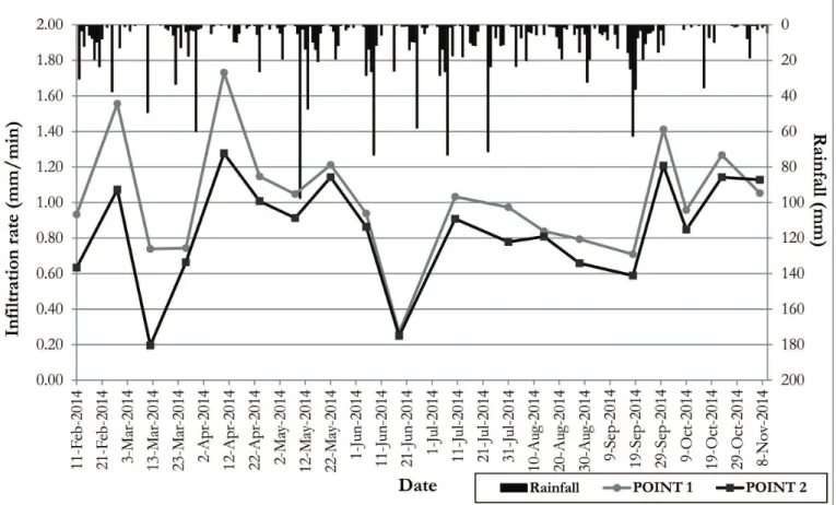
Figure 7 graphically illustrates the values for the average
of iniltration rates and the daily rainfall at Points 1 and 2 during the iniltration tests. This Figure helps in the analysis of water iniltration average rates during the rainy period.
Points 1 and 2 were monitored and analyzed. Figure 7 shows that there had been a certain change in the amount of
water iniltration. When tested on days of rainy events. there
was a decrease in the river’s contribution to the aquifer due to the change in soil saturation, modifying the relationship of the hydraulic gradient. With decreasing precipitation, the groundwater
level on the banks decreases and the river iniltration rate into
the aquifer gradually increases again. When the rain returns, the
iniltration volume of the river into the aquifer begins to decrease
after a few days.
The data in Figure 7 only conirm that in times of greater rainfall the interaction between surface water and groundwater is altered because, depending on the intensity of the rainfall, the higher water table reduces the hydraulic gradient between the river
and the aquifer, as already explained above.
Researchers around the world are continuing to investigate the thickness of the hyporheic zone layer, however, until the moment there is no methodology to quantify this with reliable
ield investigation.
The iniltration rates registered indicate that this stretch
of the Beberibe river contributes to groundwater recharge in the aquifer, although it is not a great amount.
The cylinder iniltrometer facilitates the identiication of
major aquifer recharge areas, providing information needed for the sustainable use of water resources through the preservation of these areas.
Reading the difference of hydraulic head
The reading of the hydraulic head difference by the differential piezometer was performed in order to facilitate an
understanding of the vertical low in the hyporheic zone.
It is important to note that the direction of the vertical
low of the river is not always the same, according to Leek et al.
(2009). They report that the hydraulic gradient can present spatial variation in its behavior at nearby locations.
For the Elkhorn River in Nebraska, USA, Chen et al.
(2009) observed positive and negative values of the vertical hydraulic gradient between two locations only a few meters away from each other. Cheng et al. (2010) reported similar results in the Platte River in Nebraska.
Figure 8 shows a summary of the results of the variation
of the vertical low behavior at the points studied in the Beberibe
River.
The reading 0.0 indicates a zero low point, positive values indicate a point with uplow and negative means that the point is downlow.
Figure 8 shows that the two points analyzed exhibit a
behavior change in their low. This change occurs both temporally
and between one point and another.
In relation to changes that occurred in reading the vertical
low between the points analyzed, it should be noted that Point 2 has a higher occurrence of zero low than Point 1. This fact
proves that there is a greater interaction between surface water and groundwater at Point 1 than at Point 2, regardless of the
amount and direction of water low.
The vertical hydraulic gradient between the aquifer and the Beberibe river presented three different behaviors. Possibly, the variations in readings that were found occurred as a result of
rainfall events. It’s known that the vertical low behavior undergoes
changes due to intense precipitation, which recharges the aquifer. When rain is intense, it can cause saturation in the soil. When this happens, it is highly likely that the aquifer feeds the
river in an uplow. In other cases, there is no low in any direction, as characterizes a null low.
From the results obtained with the reading of vertical low, we could see that during rainy periods most of the low in the hyporheic zone was a downlow or there was no low. In times of drought, however, where there was low, there was a greater
water contribution in the river-aquifer direction. This fact can be
explained by the increased groundwater recharge during rainy
periods.
Even if the variation of sediment is uneven, a place with sediment particles of different diameters facilitates the clogging
process. It is possible for the very ine particles to occupy the voids, signiicantly altering the permeability of the place In fact,
during the study the estimated vertical hydraulic gradient into hyporheic zone in Beberibe river, the relationship between the body of surface water and groundwater in most of the test areas
had an inluential condition characterized by surface water feeding the groundwater low (Figure 9).
During the iniltration tests and reading of the vertical low, it was observed that at the points studied in the Beberibe
river there was a river-aquifer interaction. On days with higher
precipitation, the water charge occurred through iniltration. But a few days after the rain, the amount of iniltrated water was smaller,
because the soil was over-saturated (Figure 9).
The occurrence of iniltration in the riverbed provides
the necessary moisture for riparian vegetation, in addition to the replacement of alluvial aquifers. When leakage occurs in the bed it means that there is a hydraulic connection between the aquifer and the river.
FINAL CONSIDERATIONS
Recently, there has been growing interest in river-aquifer
interaction, and in this context, the hyporheic zone deserves attention as it is inluential in this interaction.
The present study provided information on the transport of water volume in a stretch of the Beberibe river and the aquifer,
enabling a better understanding of existing processes in the
river-aquifer interaction along the Beberibe river banks, located in Recife / Olinda - PE.
Figure 9. Interaction between surface water and groundwater - vertical hydraulic gradient into the aquifer, where the water is connected directly to hyporheic zone.
Figure 8. Fortnightly readings of the vertical hydraulic gradient on the riverbed of the Beberibe river in relation to the river surface water level in the period between 11/FEB/.2014 and
The instruments used provided a better understanding of
the process of iniltration / exiltration in hyporheic zone of the
Beberibe river stretch, and may be useful for the study of water
low at other sites.
Iniltration tests and the vertical hydraulic gradient readings performed in the ield enabled a better understanding of the water exchange that takes place in the river-aquifer interaction
in the Beberibe river stretch studied in this report. In some places the river contributes to the supply of the aquifer through the descending vertical stream, however, in some situations the
low rises after the occurrence of precipitation. The average iniltration rate in the tests was 1.02 ± 0.33 mm/min at Point 1 and 0.85 ± 0.30 mm/min at Point 2, featuring a larger river-aquifer inluence at Point 1 than at Point 2.
The sandy feature found on the site enhances the percolation of water between the empty places in the sediment.
Rainfall can inluence the intensity and direction of the hyporheic low, with reduction of iniltration, when the previous
weeks have been very rainy.
ACKNOWLEDGEMENTS
The authors are grateful to professor Günter Gunkel and Maurice Sens and their teams by partnerships on the subject. To FACEPE, CAPES and CNPQ for support in the different phases of the research project. To COMPESA (Sanitation Company of Pernambuco) for research support and for permission to use
their facilities. The English version of this text has been revised by Sidney Pratt, Canadian, MAT (The Johns Hopkins University),
RSAdip - TESL (Cambridge University).
REFERÊNCIAS
ABNT – ASSOCIAÇÃO BRASILEIRA DE NORMAS TÉCNICAS.
NBR 7181: solo: análise granulométrica. Rio de Janeiro, 1984. 13 p.
ALBUQUERQUE, T. B. V.; CABRAL, J. J. S. P.; PAIVA, A. L. R.; BARCELLOS, R. L.; FREITAS, D. A. Uso do infiltrômetro
de cilindro na investigação do fluxo vertical de água na zona
hiporreica: estudo de caso no rio Beberibe - PE. In: SIMPÓSIO
DE RECURSOS HÍDRICOS DO NORDESTE, 12., 2014, Natal.
Anais... Porto Alegre: ABRH, 2014. p. 1-10.
APAC – AGÊNCIA PERNAMBUCANA DE ÁGUAS E CLIMA.
Dados climatológicos. Santo Amaro, 2014. Disponível em: <http:// www.apac.pe.gov.br>. Acesso em: 20 set. 2014.
ARANTES, E. J.; CHAUDHRY, F. H.; MARCUSSI, F. F. N. Caracterização da interação entre rio e aqüífero com o uso de
infiltrômetros. Águas Subterrâneas, v. 20, n. 2, p. 97-108, 2006.
BIANCHIN, M. S.; SMITH, L.; BECKIE, R. D. Defining the hyporheic zone in a large tidally influenced river. Journal of Hydrology,
v. 406, n. 1-2, p. 16-29, 2011. http://dx.doi.org/10.1016/j.
jhydrol.2011.05.056.
BOANO, F.; REVELLI, R.; RIDOLFI, L. Effect of streamlow
stochasticity on bedform-driven hyporheic exchange. Advances
in Water Resources, v. 33, n. 11, p. 1367-1374, 2010. http://dx.doi. org/10.1016/j.advwatres.2010.03.005.
BOULTON, A. J.; DATRY, T.; KASAHARA, T.; MUTZ, M.;
STANFORD, J. A. Ecology and management of the hyporheic zone: Stream–groundwater interactions of running waters and
their loodplains. Journal of the North American Benthological Society,
v. 29, n. 1, p. 26-40, 2010. http://dx.doi.org/10.1899/08-017.1.
CAMARGO, M. G. SYSGRAN: um sistema de código aberto para análises granulométricas do sedimento. Revista Brasileira de Geociências, v. 36, n. 2, p. 371-378, 2006.
CHEN, X. H.; SONG, J.; CHENG, C.; WANG, D.; LACKEY, S.
O. A new method for mapping variability in vertical seepage flux
in streambeds. Hydrogeology Journal, v. 17, n. 3, p. 519-525, 2009.
http://dx.doi.org/10.1007/s10040-008-0384-0.
CHENG, C.; SONG, J.; CHEN, X.; WANG, D. Statistical distribution of streambed vertical hydraulic conductivity along the Platte River, Nebraska. Water Resources Management, v. 25, n. 1, p. 265-285, 2010. http://dx.doi.org/10.1007/s11269-010-9698-5.
ENVIRONMENTAL AGENCY. The hyporheic handbook: a handbook on the groundwater–surface water interface and hyporheic zone for environment managers. Bristol: UK Environmental Agency,
2009. 262 p.
FEITOSA, F. A. F.; MANOEL FILHO, J. Hidrogeologia: conceitos
e aplicações. Rio de Janeiro: CPRM, 1997.
FOLK, R. L.; WARD, W. C. Brazos river bar: a study of significance of grain size parameters. Journal of Sedimentary Petrology, v. 27, n.
1, p. 3-26, 1957. http://dx.doi.org/10.1306/74D70646-2B21-11D7-8648000102C1865D.
GENEREUX, D. P.; LEAHY, S.; MITASOVA, H.; KENNEDY, C.
D.; CORBETT, D. R. Spatial and temporal variability of streambed hydraulic conductivity in West Bear Creek, North Carolina, USA. Journal of Hydrology, v. 358, n. 3-4, p. 332-353, 2008. http://dx.doi. org/10.1016/j.jhydrol.2008.06.017.
GOLDSCHNEIDER, A.; HARALAMPIDES, K.; MACQUARRIE, K. River sediment and flow characteristics near a bank filtration water supply: implications for riverbed clogging. Journal of Hydrology, v. 34, n. 1-2, p. 55-69, 2007. http://dx.doi.org/10.1016/j. jhydrol.2007.06.031.
GOOSEFF, M. N. Deining hyporheic zones - advancing our
conceptual and operational deinitions of where stream water and
groundwater meet. Geography Compass, v. 4, n. 4, p. 945-955, 2010.
http://dx.doi.org/10.1111/j.1749-8198.2010.00364.x.
GUNKEL, G.; HOFFMANN, A. Bank filtration of rivers and lakes to improve the raw water quality for drinking water supply.
In: GERTSEN N.; SONDERBY, L. (Eds.). Water purification.
KOBIYAMA, M. Conceitos de zona ripária e seus aspectos
geobiohidrológicos. In: SEMINÁRIO DE HIDROLOGIA FLORESTAL: ZONAS RIPÁRIAS, 1., 2003, Alfredo Wagner,
SC. Anais... Florianópolis: UFSC, 2003.
LARNED, S. T.; DATRY, T. Flow variability and longitudinal patterns in parafluvial water chemistry, aquatic invertebrates and microbial activity. Freshwater Biology, v. 58, n. 10, p. 2126-2143, 2013. http://dx.doi.org/10.1111/fwb.12196.
LAUTZ, L. K.; KRANES, N. T.; SIEGEL, D. I. Heat tracing
of heterogeneous hyporheic exchange adjacent to in-stream
geomorphic features. Hydrological Processes, v. 24, n. 21, p.
3074-3086, 2009. http://dx.doi.org/10.1002/hyp.7723.
LAWRENCE, J. E.; SKOLD, M. E.; HUSSAIN, F. A.; SILVERMAN,
D. R.; RESH, V. H.; SEDLAK, D. L.; LUTHY, R. G.; MCCRAY, J.
E. Hyporheic zone in urban streams: a review and opportunities
for enhancing water quality and improving aquatic habitat by active management. Environmental Engineering Science, v. 30, n. 8, p. 480-501, 2013. http://dx.doi.org/10.1089/ees.2012.0235.
LEE, D. R. A device for measuring seepage flux in lakes and estuaries. Limnology and Oceanography, v. 22, n. 1, p. 140-147, 1977.
http://dx.doi.org/10.4319/lo.1977.22.1.0140.
LEEK, R.; WU, J. Q.; WANG, L.; HANRAHAN, T. P.; BARBER, M. E.; QIU, H. Heterogeneous characteristics of streambed saturated hydraulic conductivity of the Touchet River, south eastern Washington, USA. Hydrological Processes, v. 23, n. 8, p. 1236-1246,
2009. http://dx.doi.org/10.1002/hyp.7258.
LEHR, C.; PÖSCHKE, F.; LEWANDOWSKI, J.; LISCHEID, G. A novel method to evaluate the effect of a stream restoration on the spatial pattern of hydraulic connection of stream and groundwater. Journal of Hydrology, v. 527, p. 394-401, 2015. http://
dx.doi.org/10.1016/j.jhydrol.2015.04.075.
LENCIONI, V.; SPITALE, D. Diversity and distribution of benthic and hyporheic fauna in different stream types on an alpine glacial floodplain. Primary Research Paper. Hydrobiologia, v. 751, n. 1, p. 73-87, 2015. http://dx.doi.org/10.1007/s10750-014-2172-2.
LEWANDOWSKI, J.; ANGERMANN, L.; NÜTZMANN, G.; FLECKENSTEIN, J. H. A heat pulse technique for the determination of small-scale flow directions and flow velocities in the streambed of sand-bed streams. Hydrological Processes, v. 25, n. 20, p. 3244-3255, 2011. http://dx.doi.org/10.1002/hyp.8062.
MAIER, H. S.; HOWARD, K. W. F. Inluence of oscillating low on hyporheic zone development. Ground Water, v. 49, n. 6, p. 830-844, 2011. PMid:21309768.
http://dx.doi.org/10.1111/j.1745-6584.2010.00794.x.
PACKMAN, A. I.; MACKAY, J. S. Interplay of stream–subsurface
exchange, clay particle deposition, and stream bed evolution. Water Resources Research, v. 39, n. 4, p. 1097-1102, 2003. http://dx.doi.
org/10.1029/2002WR001432.
PAIVA, A. L. R. O processo de filtração em margem e um estudo de caso no rio Beberibe. 2009. 149 f. Tese (Doutorado em Engenharia Civil)
- Universidade Federal de Pernambuco, Recife, 2009.
PERNAMBUCO. SRHE – Secretaria de Recursos Hídricos e
Energéticos. Projeto de dragagem do rio Beberibe no trecho entre a BR-101 e a ponte da avenida Olinda (trechos 1 a 5). Recife, 2012. v. 1.
ROSENBERRY, D. O. Integrating seepage heterogeneity with the use of ganged seepage meters. Limnology and Oceanography, Methods, v. 3, n. 2, p. 131-142, 2005. http://dx.doi.org/10.4319/ lom.2005.3.131.
ROSENBERRY, D. O.; PITLICK, J. Effects of sediment transport and seepage direction on hydraulic properties at the sediment-water interface of hyporheic settings. Journal of Hydrogeology, v. 373, n. 3-4,
p. 377-391, 2009. http://dx.doi.org/10.1016/j.jhydrol.2009.04.030.
SHEPARD, F. P. Nomenclature Based on Sand-Silt-Clay Ratios. Journal of Sedimentary Petrology, v. 24, n. 3, p. 151-158, 1954.
SOPHOCLEOUS, M. Interactions between groundwater and surface water: the state of the science. Hydrogeology Journal, v. 10, n. 1, p. 52-67, 2002. http://dx.doi.org/10.1007/s10040-001-0170-8.
SUGUIO, K. Introdução à sedimentologia. São Paulo: Edgard Blücher/
EDUSP, 1973. 317 p.
VELICKOVIC, B. Colmation as one of the processes in interaction between the groundwater and surface water. Facta Universitatis, Series. Architecture and Civil Engineering, v. 3, n. 2, p. 165-172, 2005.
http://dx.doi.org/10.2298/FUACE0502165V.
WILLIAMS, D. D. Towards a biological and chemical deinition of the hyporheic zone in two Canadian rivers. Freshwater Biology, v. 22,
n. 2, p. 189-208, 1989. http://dx.doi.org/10.1111/j.1365-2427.1989. tb01095.x.
Authors contributions
Tatiane Veras: Analysis of hyporheic zone, preparation and
implementation of methodological and experimental design,
processing and analysis of data, discussion of results, writing and revision.
Jaime Cabral: Development of the work methodology, analysis
of river-aquifer interaction, writing and revision.
Anderson Paiva: Preparation of graphs and igures, interpretation
and discussion of results, writing and revision.
Roberto Barcellos: Treatment of grain size data, interpretation and discussion of results related to hyporheic sediments.