ISSN 1553-345X
© 2010 Science Publications
Corresponding Author: Adriano Fiorucci, Department of Environment and Geo-Engineering, Politecnico di Torino DITAG, Corso Duca degli Abruzzi, 24 10129 Torino Italy
1
Hydrogeological Prognosis with Regard to
Realisation of the New Colle Di Tenda Road Tunnel
1Cinzia Banzato, 1Massimo Vincenzo Civita, 1Adriano Fiorucci,
1Bartolomeo Vigna and 2Salvatore Papale
1Department of Environment and Geo-Engineering,
Politecnico di Torino DITAG, Corso Duca degli Abruzzi, 24 10129 Torino Italy
2Azienda Nazionale Autonoma delle Strade Statali (ANAS) S.p.A.,
Via Monzambano, 10 00185 Roma Italy
Abstract: Problem statement: The doubling of Tenda pass road tunnel jointing SW France to Piedmont (Italy) was planned to penetrate a complicate rock structure in which several complex play an hydrogeologic role including carbonate-Karst aquifer between flysch impervious complexes. The main problem of the project is the presence of an hydraulic circulation feeding a spring of social and economic great importance discharging into a railroad tunnel below. Approach: The authors was charged by ANAS, Italian National Roads Authority, to execute a complete hydrogeologic prognosis of the situation that will be determinate by the excavation of the new tunnel and forecast as well as possible the hazard for the tapped spring. Results: Two years research have included a complete hydrogeologic and hydrochemical survey all the hypothesized structure feeding the spring, with several bore holes used as observation wells, the use of several monitoring device for the discharge and the chemical characters of spring, a lot of laboratory tests on cements and micro-cements and other materials used in waterproofing and sustain the rocks during the excavation and the concrete lining of the tunnel. Conclusion: The study ends with the evaluation of the vulnerability of the spring and the forecasting of contamination and depletion of the spring.
Key words: Colle di tenda, parallel monitoring, hydrogeological prognosis, road tunnel, carbonate aquifer, electrical conductivity, chemical-physical variations, depletion coefficient, human consumption, overlaid permeability, sulphate-bicarbonate-calcic facies
INTRODUCTION
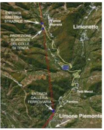
With the prospect of doubling the road tunnel that, via Colle di Tenda, joins Italy and France, the National Roads Authority (ANAS) based in Rome asked the Dipartimento di Ingegneria del Territorio, dell’Ambiente e delle Geotecnologie (DITAG) of Politecnico di Torino to make the preliminary hydrogeological prognosis, based on existing information and on information gathered during the research project itself. The geographical location of the area under assessment is on the border between Italy (southern Piedmont) and France (Provence-Alpes-Côte d'Azur), at the Colle di Tenda pass, where there is an existing road tunnel and a railway tunnel (Fig. 1).
In agreement with its French counterpart, ANAS considered two initial approaches to the project:
• Widening of the existing road tunnel and
excavation of a new tunnel (high altitude solution)
• Excavation of a new twin-tube tunnel (low altitude solution)
Table 1 shows the relevant data for the existing and planned tunnels.
Fig. 1: Location of the area of interest
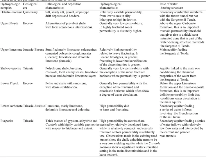
Fig. 2: Detail showing the area under examination. The aerial view shows the entrances to the two tunnels, the projection of the Sorgente di Tenda on the natural surface and the route of the rail tunnel
Table 1: Specifications for existing and planned tunnels
Altitude of Altitude
entrance on of entrance
Italian on French side Section Length Tunnel side (m a.s.l.) (m a.s.l.) (m2) (m) Rail tunnel 1037 1010 8.099 Road tunnel 1320 1276 34 3.195 Planned road tunnel 1320 1276 63 3.268
In 1990 the spring was tapped in the tunnel by the Langhe and Alpi Cuneesi Aqueduct; this infrastructure is very important for the social-economic development of a vast area, which has few other water resources suitable for human consumption and which supplies, along with some other sources, a population of over 100,000.
The purpose of the prognosis includes gaining an understanding of the hydrogeological situation of the
entire rock mass covered by the works, in order to foresee both problems that may arise during construction due to the presence of water and also the possible effects that excavations may have on the important water resource that is tapped from the railway tunnel below. With this in mind, a series of operations have been planned, set up and carried out, the most important of which are as follows:
• General hydrogeological survey to identify the structure of the aquifer and the area supplying it
• Census of internal and external groundwater points with qualitative-quantitative monitoring
• Positioning of a number of well loggings and interpretation of resulting data as regards the water-bearing structure
• Assessment of the effects of excavation on the water resource, from the quantitative point of view and also because of the materials used for lining, waterproofing and whatever may be necessary due to the karst nature of the rock formations
This study summarises over three years’ work and the results achieved, with completion of the prognosis.
MATERIALS AND METHODS
3
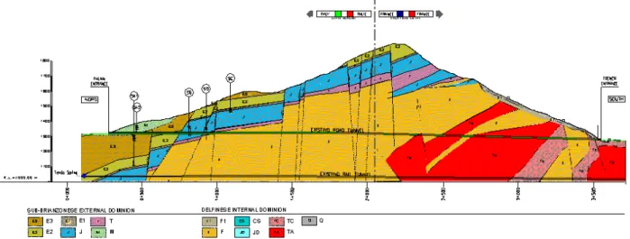
Table 2: Hydrogeologic formations in Colle di Tenda
Hydrogeologic Geological Lithological and deposition Hydrogeological Role of water
complex era characteristics characteristics -bearing structure Detritic-moraine Quaternary Silt, sandy silt, gravel, slope-type Relatively variable permeability, Secondary aquifer that interferes
drift deposits and headers. from low values in silty with the future tunnel but not lithotypes to high in detritic. with the Sorgente di Tenda. Upper Flysch Eocene Alternations of prevalent shale Generally very low permeability. Above the upper Carbonate with local arenaceous intercalations. In highly fractured zones formation, this is an important
permeability is distinctly higher. overlaid permeability threshold that gives rise to a thick karst saturated zone that is part of the water-bearing structure that feeds the Sorgente di Tenda. Upper limestone Jurassic-Eocene Stratified marly limestone, calcarenites, Relatively high permeability Main aquifer feeding
cemented polygenic conglomerates related to heavy fracturing. In the Sorgente di Tenda. (Eocene); limestone and dolomite Eocene lithotypes, in general,
limestone (Jurassic) fracturing is lower but karstification of the discontinuities is greater.
Shale-evaporite Triassic Polychrome shale, breccias, Generally very low permeability with Aquifer linked to the main one Carniola, local chalky lenses, limestone the exception of the more fractured conditioning the chemical breccias and dolomite limestone layers horizons where permeability is greater. properties of the water from
the Sorgente di Tenda. Lower Flysch Eocene Pelite and shale with sandstone, Generally low permeability with the Below the upper Limestone
with dense stratification. exception of the fractured and formation and the Shale-evaporite cataclastic horizons which often show formation, this is an important a degree of water circulation. definite permeability limit that conditions water circulation in the main aquifer.
Lower carbonate Triassic-Jurassic Limestone, marly limestone, High permeability due Secondary aquifer feeding dolomitic limestone and dolomite. to karst and fracturing. a series of water inflows
involving the French section of the rail tunnel.
Evaporite Triassic Thick masses of gypsum, anhydrite and High permeability in sectors chara Secondary aquifer feeding a series Carniole with highly variable geometries cterised by relatively developed karst, of water inflows with relatively with respect to thickness and extent. while in relatively compact and scarcely low flow rates and intercepted by
fractured sectors permeability is relatively the current and planned low. Observations made in the existing road road tunnels. tunnel show the chalk-anhydrite mass to be
a very low yielding aquifer while the Carniole horizons show a significant water circulation setting in the main discontinuities and in the
karst network.
The water-bearing structure of the area is conditioned by the presence of a main thrust surface, dipping to the NE, which divides the autochthonous sedimentary series of the Dominio Esterno Delfinese
from the Falda Sub-Brianzonese. This surface is displaced by numerous sub-vertical tectonic discontinuities that significantly complicate the geometry of this contact. Moreover, within the Dominio
Esterno Delfinese there are several discontinuity
surfaces, also dipping towards NE, between the Flysch formation and the Evaporitic formation.
In the Falda Sub-Brianzonese succession the upper
Carbonate formation, which contains the main aquifer, is in contact with the underlying Argillite-Evaporite formation concerned with the thrust plane and hence, characterised by considerable deformations with variations in thickness. This horizon conditions groundwater circulation towards the Sorgente di Tenda.
The upper Flysch formation, above the upper Carbonate formation, acts as an important overlaid permeability threshold that gives rise to a thick karst
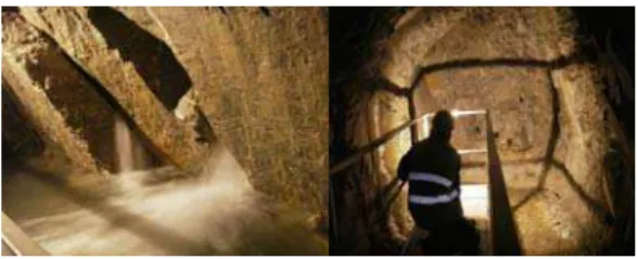
saturated zone that is part of the water-bearing structure that feeds the main spring. Figure 3 and 4 show the plan view and section of the mountainous massif, as taken from observations made in the current road tunnel.
The area feeding the spring is a narrow, straight NW-SE band, which goes from the deep Cabanaira valley to the Val Grande di Palanfrè, covering a total of about 8 km2. GIS processing (Civita et al., 1999) was applied to the HYDRAC simulation model (Civita et al., 1982) to calculate the potential balance. The infiltration contribution of the overall area was found to be 0.24 m3 sec1 and hence only a little lower than the average flow rate for the spring, as measured between 01/01/2003 and 25/11/2003 and amounting to 0.25 m3 sec−1.
Fig. 3: Geological map of the current road tunnel with positions of the main water flows. (Source: ANAS)- Modified and re-drawn. (1) Cold water, (2) cold seep, (3) hot water, (4) hot seep, (5) humid area on the base of the tunnel, (6) cold humid area, (7) hot humid area
Fig. 4: Geological section of the current road tunnel with positions of the main water flows. (Source: Cuneo Province)-modified and re-drawn. (M) Morainic deposit, (E3) Flysch, (E2) Nummulitic limestone, (E1) Polygenetic conglomerate, (J) Limestone, (T) Dolomitic limestone-dolomite. (Q) Several kinds of deposit, (F1) Rework flysch, (F) Sandstone-pelitic flysch, (CS) Marl limestone, (JD) Limestone and dolomitic limestone, (TC) Clay and carniole, (TA) Gypsum and anhydrite
Table 3: Properties of the core drillings
Drilling Altitude (m a.s.l.) Depth (m) Core sample Posizione tratto filtrato (m)
SB 1453 150 Continuous core sample from 100-150
SC 1565 110 Double sampler from 85-100
SA 1385 280 Continuous core sample from 240-275
SA2 1385 75 from 50-75
SI3 1507 232 Continuous core sample
Due to violent inrushes (Fig. 6), study on summarises the information shown by the core drillings, while their positions are shown in Fig. 5.
Between the set points at 2489 and 3058 m from the northern entrance to the railway tunnel, a thick carbonate series was found, consisting of highly permeable Jurassic and Eocene limestone and giving flow rates of the order of 0.4 m3 sec−1, on average. The aquifer is intercepted in the zone where the contact (permeability threshold) is situated, between the upper limestone formation and the upper Flysch formation. The rail tunnel was delayed for about 3 years until they managed to divert the various water flows into a channel that discharged into the Vermenagna stream. In
5 Fig. 5: Reconstruction of the hydrogeological structure
of the N side of Col di Tenda based on surveyor’s report
Fig. 6: On the left: Water flows from the fractured mass giving rise to the Sorgente di Tenda; on the right: Excavation face of the tapping tunnel
Fig. 7: On the left: the current tapping works; on the right: surge tank of aqueduct
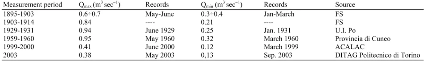
Measurements of spring flow rate have been taken since 1895, over differing periods, to obtain maximum and minimum values (Table 4). Italian National Railways (FS) technical staff also made an important discovery: the effect of precipitation is felt at the spring about 3-4 days after rain has started, while the flow begins to decrease after at least 5-6 days subsequent to the end of rain events.
From 2nd August 2004 until the present, an automatic sensor installed by the Langhe and Alpi Cuneesi Aqueduct has been taking continuous measurements of the water levels at the Sorgente di Tenda.
On 10.11.04 the Turin section of ANAS installed an automatic turbidity recorder at the same point and this is still in operation.
On 21.07.05, at the SI3 well logging, which had been fitted with an observation well, an automatic water level and temperature recorder was installed by DITAG.
At the spring tap in the Colle di Tenda rail tunnel, DITAG installed an automatic recorder for water level, temperature and specific electrical conductivity and began recording in December 2005. Measurements taken at the chosen monitoring point, directly at the spring tap, should be considered more reliable than those taken at the surge tank, which may be subject to interference due to operations in the surge tank itself.
As from 21.07.05, precipitation data were taken from the (Piedmont ARPA) Limone Pancani weather gauging station situated near Colle di Tenda.
RESULTS
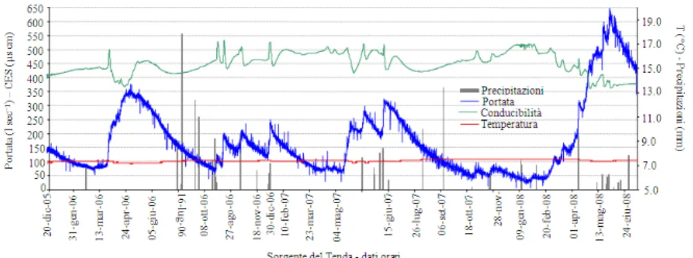
Acquisition of all these records has made it possible to collate a considerable series of data regarding the hydrogeological structure of the whole zone and these will be compared and discussed in the following paragraphs. Figure 8 shows the recorded data for the daily flow rates of the spring together with the corresponding data for water conductivity and temperature.
For the same period, Fig. 9 shows the behaviour at the observation wells installed in the well loggings described above.
In order to verify the natural turbidity of the spring water, which is generally related to changes in flow rate at emergence and to evaluate the data in order to predict situations in which the carbonate aquifer may undergo stress as a result of construction of the new tunnel, in November 2004 a turbidity meter was installed at the aqueduct surge tank. Records taken over a period of more than one year, in the complete absence of interference with the aquifer, revealed an unusual situation (Fig. 10).
In general turbidity was nil, with the exception of periods in springtime when, after high flows due to snow melt, there was a significant increase in turbidity corresponding to the depletion stage of the flood itself.
Fig. 8: Continuous monitoring data: flow rate, temperature and electrical conductivity of the spring water with precipitation for the feed area (Dec. ’05-Jul. ’08)
Fig. 9: Comparison of piezometric levels in observation wells, behaviour of spring flow rate and precipitation
Fig. 10: Turbidity in spring water (Dec ’05-Jul ‘08)
Aqueduct technical staff also noted visible turbidity in the water, reporting the arrival of whitish-coloured water. It is not easy to interpret these phenomena, both because they do not always occur after high flow events and also because, when they do occur, they may coincide with or be delayed with respect to peak flows. The most acceptable hypothesis leads one to think that arrival of turbidity is mainly due to snow melt characterised by modest but continuous input over very long periods. The delays with respect to peak flood could be related to the hydrodynamic
characteristics of the aquifer and to the magnitude of the infiltration contribution.
7
Table 4: Previous records of flow rate of the Sorgente di Tenda
Measurement period Qmax (m3 sec−1) Records Qmin (m3 sec−1) Records Source
1895-1903 0.6÷0.7 May-June 0.3÷0.4 Jan-March FS
1903-1914 0.84 ---- 0.21 ---- FS
1929-1931 0.94 June 1929 0.25 Jan. 1931 U.I. Po
1959-1960 0.95 May 1960 0.32 March 1960 Provincia di Cuneo
1999-2000 0.41 June 2000 0.12 March 1999 ACALAC
2003 0.38 May 2003 0,13 Sep. 2003 DITAG Politecnico di Torino
Note: FS = Italian State Railways; U.I. Po = ACALAC = Consorzio per l’Acquedotto delle Langhe e delle Alpi Cuneesi (Aqueduct Consortium)
Table 5: Results of chemical analysis of the samples taken from the Sorgente di Tenda at different times. Sampling date Ca2+(mg L−1) Mg2+(mg L−1) Na+ (mg L−1) K+ [(mg L−1) Cl- (mg L−1) SO
42- (mg L−1) HCO3- (mg L−1) NO3-(mg L−1)
15/02/2003 65.01 11.18 1.51 0.43 0.63 96.62 124.29 4.03
30/04/2003 59.32 8.75 1.31 0.41 0.77 77.50 127.71 4.17
17/07/2003 70.30 8.75 1.66 1.09 1.37 89.59 108.43 4.36
03/09/2003 72.71 7.29 1.82 0.45 0.95 110.92 125.02 4.64
Table 6: Chemical analysis of groundwater concerned by the study
EC at Na+ K+ Ca2+ Mg2+ Cl- NO
3 - SO
4
2- HCO 3
- TDS
25°C TH (mg (mg (mg (mg (mg (mg (mg (mg (mg Mg2+
/ SO4
2-/ Campione Data pH T (°C) (µS cm−1
) (°f) L−1
) L−1
) L−1
) L−1
) L−1
) L−1
) L−1
) L−1
) L−1
) Ca2+
HCO3
C1 Jan 2005 7.84 7.9 1633 101.6 2.31 1.87 361.12 27.72 0.56 0.25 869.40 134.91 1398.14 0.127 8.187
C2 Jan 2005 7.87 7.9 1882 121.7 2.38 2.02 435.67 31.36 0.58 0.20 1060.80 137.22 1670.24 0.119 9.820
C3 Jan 2005 7.01 6.3 346 17.9 1.14 0.46 65.33 3.89 2.49 4.77 7.19 204.10 289.38 0.098 0.045
SA Oct 2006 6.38 6.2 330 16.8 3.91 2.28 50.90 9.94 1.04 0.10 13.96 194.64 276.78 0.322 0.091
SA Jul 2008 7.48 6.3 365 18.3 2.50 0.97 70.16 1.93 1.11 2.77 9.98 206.17 295.59 0.045 0.062
SA2 Oct 2006 6.66 6.4 290 15.0 3.15 1.73 51.29 5.36 0.71 1.26 4.73 181.89 250.11 0.172 0.033
SA2 Jul 2008 Observation well that was destroyed during the works.
SB Oct 2006 6.90 5.6 337 17.0 1.97 0.97 64.77 1.99 0.23 0.46 8.76 197.81 276.96 0.051 0.056
SB Jul 2008 7.96 9.0 287 15.4 1.05 0.75 59.19 1.42 0.50 0.99 6.13 177.45 247.47 0.040 0.044
SB Jul 2007 7.90 8.9 297 15.5 0.98 1.00 60.02 1.36 1.40 1.28 14.56 174.62 255.21 0.037 0.106
SC Oct 2006 6.40 5.2 375 18.7 1.88 0.94 73.09 1.19 0.48 2.21 6.47 217.28 303.54 0.027 0.038
SC Jul 2008 7.36 7.5 288 15.9 1.20 0.38 59.95 2.31 0.51 3.39 5.77 176.90 250.40 0.063 0.041
SC Jul 2007 7.40 7.4 379 18.3 1.86 2.98 71.62 1.06 2.80 2.72 13.51 206.36 302.89 0.024 0.083
SI3 Dec 2004 7.60 7.5 264 13.6 5.39 0.91 48.10 3.89 4.78 1.81 5.61 165.78 236.25 0.133 0.043
SI3 Oct 2006 6.69 6.0 258 14.5 1.00 0.26 52.13 3.65 0.32 2.75 2.31 173.65 236.05 0.115 0.017
SI3 Jul 2008 Dry
Tenda Spring Dec 2004 7.85 6.0 440 22.6 2.09 < 0.01 76.15 8.75 0.82 4.20 127.27 119.10 338.39 0.189 1.357 Tenda Spring Oct 2006 6.38 7.2 447 23.4 1.36 0.36 89.59 2.48 0.55 2.00 118.41 124.78 339.53 0.046 1.206 Tenda Spring Jul 2008 7.84 7.1 371 19.6 1.21 0.40 68.61 6.09 0.89 2.86 81.95 135.35 297.36 0.146 0.769 Tenda Spring Jul 2007 7.82 7.1 484 24.3 1.05 2.03 84.05 7.96 1.94 2.50 132.69 131.48 363.70 0.156 1.282
T2 Dec 2004 8.10 4.0 373 16.5 12.39 1.10 57.72 5.11 17.91 4.41 12.83 187.50 298.96 0.146 0.087
Note: TH = Total Hardness expressed in French degrees [°f] (1 French degree = 10 mg L−1
CaCO3) EC = Electrical Conductivity TDS = Total Dissolved Solids. In this case this means the sum of the ion content less the silica contribution. In the characteristic ratios Mg2+
/Ca2+
and SO42-/HCO3- ion concentration is expressed as meq L−1
The fluorometer installed at the Colle di Tenda Spring operated continuously for over two months. During this period there was no record of tracer arrival at the spring. Non-arrival of the dye could be related to reduced groundwater flow and significant dispersion and diffusion of the dye itself in the extensive saturated zone of the system feeding the spring, or to reduced water circulation in the rock actually monitored by the observation wells.
Chemical properties of the groundwater: In 2003 samples of water were taken from the Sorgente di Tenda in different periods, which were characterised by a range of hydrodynamic situations. The results of chemical analysis are shown in Table 5.
The data show that the spring water is characterised as bicarbonate-sulphate-calcic in periods of high flow, but it becomes sulphate-bicarbonate-calcic in periods of low flow. A high sulphate level is
probably linked with evaporite levels present at the base of the carbonate succession. The sulphate/bicarbonate ratio is subject to variations that are well correlated with the hydrodynamic regime. As a matter of fact decreased flow is followed by an increase in the above ratio, caused by an increase in sulphate level, as against a lesser change in bicarbonate content.
In December 2004, water samples were taken from the Sorgente di Tenda, at the water inflows from the present road tunnel (T2) and at observation well SI3 situated at the ski slopes at 1400 m a.s.l. Table 6 shows the results of analysis.
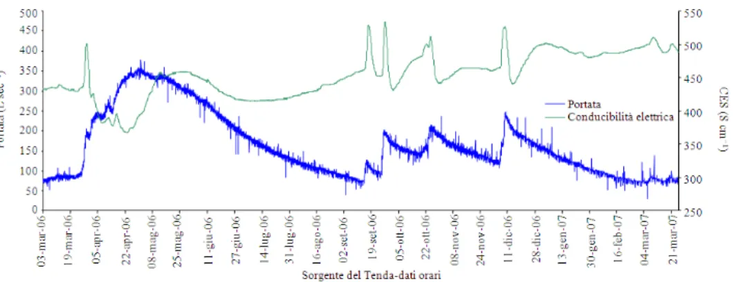
Fig. 11: Variation in temperature (on the left) and electrical conductivity of the water, measured continuously (Dec. ’05-Dec. ’06)
This, therefore, seems to confirm that the spring water has a sulphate-bicarbonate-calcic facies, which can be linked to groundwater circulation that, in addition to the carbonate formation, also involves levels rich in chalk, anhydrite and “Carniola” (vacuolar limestone), which are probably situated at the principal thrust plane between the upper carbonate formation and the lower Flysch formation. These differences seem to be mainly related to the water time of travel in the carbonate aquifer, which is longer for the Spring than that of observation well SI3 and of the water inflows in the road tunnel.
Subsequently (January 2005) the main water inflows found in the present tunnel were sampled, in particular those at distances 73 m (C3 for the morainic-drift formation), 2856 m (C1 for the evaporite formation) and 2871 m (C2 for the evaporite formation).
Comparison of the analytical results for the two practically simultaneous field tests makes it possible to state that C3 (morainic-drift formation) and T2 (main inflow in the tunnel on the Italian side) are very similar (the presence of alkaline chlorides in T2 can be associated with salt-spreading on the tracks). Sample SI3 indicates a bicarbonate-calcic facies while the Sorgente di Tenda shows a sulphate-bicarbonate-calcic facies although both are members of the same hydrogeological complex (upper Carbonate). Samples C1 and C2 in the sulphate-calcic facies indicate circulation related to the Carniola horizons of the evaporatic aquifer that is totally independent of the one feeding the Sorgente di Tenda.
The data for observation wells SA, SA2, SB and SC also show chemical facies that are markedly different from those of the Sorgente di Tenda.
Comparison of flow and temperature behaviour of the spring (Fig. 8) shows substantially constant temperature values between a maximum of 7.40°C and a minimum of 7.05°C and hence an annual variation of
approx. 0.35°C. This data shows that the direct contribution of newly infiltrated water is secondary: in the springtime, when snow melt is particularly important and there is infiltration of very low temperature water, the effect at the spring is only a mild decrease in temperature, which always stays above 7°C. The value of electrical conductivity of the water, over the whole observation period (Fig. 8), shows more marked variations that are directly linked with flow behaviour. In order to highlight these properties, the data for measurements taken over one year have been considered (Fig. 11). Sudden increases in conductivity during the initial stage of flood are shown clearly and these are followed by equally rapid decreases, which indicate a piston action associated with the arrival of water of relatively high mineral content present in the aquifer. The peak is followed by a temporary decrease in conductivity for which the minimum generally corresponds with peak flood. This decrease is not related to the direct arrival of newly percolated water, which is characterised by its very low mineral content, but rather by groundwater contributions arriving from different sections of the water-bearing structure under examination. As already stated, water with varying mineral content, in particular as regards sulphate levels, arrives at the spring, from different sections of the area feeding the spring itself. During the depletion period subsequent to flood further increases and decreases in mineral content can be observed and these are always associated with contributions from different sectors of the water-bearing structure.
9
Table 7: Specific hydrodynamic parameters for the spring, based on simulation models
Depletion QMAX (m3 sec−1) QR0 (m3 sec−1) α W0(Mm3) ∆W (Mm3) Tr (%) tmr (y) DT(d) TD (d) May ’06-Sep. ‘06 0.31 0.26 001 2.32 1.70 74 1.33 75 65 Dec ’06- Mar.’07 0.21 0.18 0.01 1.27 0.81 64 1.61 81 44
Table 8: Values of turbidity, pH, Electrical Conductivity, Al3+ and Cr6+ in the cement-water solutions
Cement/water Turbidity Elecctrical Conductivity
concentration (g L−1) (NTU) pH at 20°C (µS cm−1) Cr6+ (µg L−1) Al3+ (µg L−1)
0.00 0.06 8.00 399 <1.0 7.9
0.01 1.48 8.05 395 <1.0 30.9
0.05 10.90 8.32 372 <1.0 60.7
0.10 41.22 8.65 331 <1.0 48.3
0.20 90.96 9.45 287 1.5 97.9
0.25 121.63 10.54 322 1.5 83.6
0.30 10.75 370 2.9 96.8
0.40 11.08 510 4.1 153.8
0.50 11.26 668 5.0 185.6
1.00 11.56 1074 8.1 541.5
(a)
(b)
Fig. 12: (a) Depletion curve for the Sorgente di Tenda (Dec. ’06-Mar. ’07); (b) Linearisation of the hydrograph
Examination of the spring outflow curves that were recorded between the end of 2005 and June 2008 has given a better understanding of the characteristics of the spring system and of the behaviour of the aquifer feeding it.
The rising curves show no extraordinary features apart from the influence of delayed precipitation (snow) that breaks up the continuity, as is normal in high altitude feed areas and as conductivity behaviour shows.
The simulation model for the falling/depletion (recession) curves, applied to the relevant parts of the 2006-07 hydrographs (Fig. 12), provides much more information.
The first of the two curves initially indicates a system that is highly influenced by delayed infiltration (snow melt) and only more than one month after annual peak flow rate does scarcely influenced depletion begin. The whole depletion curve seems to be “stepped” by little parasite flood that are generally reabsorbed in short spaces of time. These little parasite flood can be interpreted as discharge from small circuits moving at faster rates (karst conduits, broader fractures). These phenomena are also found, although to a lesser extent, during the 2007 depletion that, however, seems to be hardly affected overall.
The hydrodynamic parameters calculated for the two curves are given in Table 7, using an exponential model (Maillet, 2010), rather than later more complex approaches (Civita, 2008).
From the calculations it seems clear that, irrespective of the maximum values, the depletion coefficient (α) is practically the same in the two cases. The values of α have rather high absolute values for a fractured karst aquifer, probably because of the low volume of the recharge area. On the other hand, the minimum flow values (“base flow”, auth.) are relatively high, as if a transfer from another water body under pressure is also contributing to spring feed; this hypothesis is also supported by the relative increase in conductivity and temperature corresponding with the end of depletion.
The effective annual reserve (W0) is relatively high
in relation to flow rates, as is the drainage capacity index (∆W). Renewal rate is evidently high and average renewal time (tmr) is hence short. Delay time, although
the least favourable conditions (medium vulnerability in this case) should have the following dimensions by (Civita, 2008):
Immediate Protection Zone (IMPZ): resembling a rectangle that, with respect to the tapping point, is 20m long upstream, plus 5m downstream, with a width of 15 m (called the “d” limit);
Inner Protection Zone (IPZ): Resembling an upturned trapezoid that is oriented according to the local direction of flow of the aquifer, the lesser base coinciding with the theoretical “d” limit downstream of the IPZ, opening with sides at an angle of at least 30° with respect to the edges of the IPZ, while the upstream is edge is marked by an arc of circle centred at the centre of the IPZ and having a radius of 400 m.
The construction works are hence found to be outside the protection zones system of the Sorgente di Tenda, being at a distance of at least 575 m from the tapping works.
Risk of qualitative deterioration: Since the new tunnel is already at the final project design stage, in order to estimate the possible impact of excavations just the same, data have been collected from two construction sites for important underground works. These sites interfere with the aquifer and preventive consolidation is planned, using cement mortar. Although these works are in unconsolidated rock, the comparative situations will certainly be useful for prognosis purposes. For the two aforementioned sites water samples were taken both upstream and downstream. Chemical analysis covered all the chemical-physical parameters covered by Italian Legislative Decree DL 31/01 concerning water drinkableness, in particular with regard to substances such as acrylamide and vinyl chloride. In addition, the most abundantly used substances, because of their low cost, were considered, as well as cement mixtures with admixtures (such as set accelerators or retarders, plasticisers), sodium silicate-based mixtures, resins. These substances may have varying degrees of toxicity. Under hydrogeological conditions such as those of Col di Tenda, it is possible that use of cement mortar, in the excavation sector involving the carbonate aquifer in particular, could cause arrival of turbidity at the spring, with a significant increase in pH, hence precluding water utilisation without specific extra treatment.
tests were taken. These tests had been carried out by authorised laboratories (in compliance with Italian DM 05/02/08) on the mineral-organic product, Global Foam SP. This product is one of a series of resins with similar chemical structure but different degrees of expansion. Consolidation with cement mixtures does take place in similar situations, but using mixture supplements that may release a series of active ingredients to the water, which would arrive simultaneously with the cement solutions. The study focussed on the latter in order to find a series of chemical-physical parameters that would be easy to monitor continuously at the spring, so as to prevent polluted water reaching the consumer.
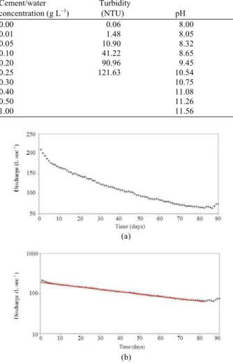
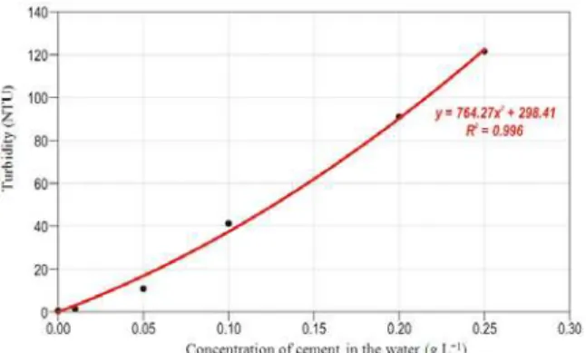
Different quantities of cement were added to some samples of water taken from the Sorgente di Tenda (0.01, 0.05, 0.1, 0.2, 0.25, 0.3, 0.4, 0.5, 1 g L−1). Turbidity, pH, electrical conductivity and concentrations of Cr6+ and Al3+ ions were then measured (Table 8).
Turbidity was measured using a turbiditimeter that was immersed in the previously shaken water sample for one minute.
The graph in Fig. 13 shows the existence of a relationship between the two parameters. The meter is already able to detect water turbidity at even low cement concentrations. At 0.05 g L−1 colour changes to the water are invisible to the naked eye, but the instruments already detect a significant difference, of the order of 10 NTU, compared to the “clear” sample.
However, monitoring turbidity alone is insufficient for demonstrating the presence of cement and admixtures in suspension in the aquifer. Therefore, the effects of cement at low concentrations on pH, on electrical conductivity and on Al3+ and Cr6+ content have been studied under the assumption that a cross-comparison of the results for these five parameters will improve the likelihood of detecting the arrival of very low concentrations of cement at the spring and consequently, of substances that could be dissolved in the water, originating from the mixtures used in the cement.
Addition of cement to spring water generates the formation of an alkaline mixture, caused by the release of the calcium, sodium and potassium hydroxides present in Portland-type cement. The results of chemical analysis of the cement/water solutions are shown in Table 8 and in Fig. 14.
11 Fig. 13: Graph showing turbidity against concentration
of cement in water
Fig. 14: Graph showing the parameters under consideration as functions of concentration of cement in water
Italian law DL of 2 February 2001 N. 31 rules that for “water intended for human consumption” the pH must fall between 6.5 and 9.5. It should be noted that the “clear” water sample taken from the spring has a pH of 8.00.
While there are no significant changes in pH for concentrations of up to 0.1 g L−1 cement in water, at a concentration of 0.2 g L−1 the pH is already greater than 9.40 and continues to increase, reaching 11.56 at 1 g
L−1. Between 0.1 and 0.2 g L−1, therefore, a sudden increase in pH is observed. Below 0.1 g L−1 the changes are neither very significant nor such as to be unambiguously attributable to anthropic activity.
As regards conductivity, the “clear” sample of spring water gave a value of 399 μS cm−1
. When cement was added in the quantities listed above, the values of electrical conductivity tended first to decrease to a value of 287 μS cm−1
at concentrations of 0.2 g L−1 and then increase quite rapidly in a linear fashion to a value of 1074 μS cm−1
at concentrations of 1 g L−1. The initial decreases in conductivity, for cement concentrations below 0.2 g L−1 can be attributable to precipitation of CaCO3, which occurs due to the
addition of the calcium oxide component of the cement. This phenomenon continues until the CO32- ion is
completely removed and then, for subsequent levels of added cement, the electrical conductivity increases according to the ion contribution from the cement itself.
To complete the study, concentrations of Cr6+ e Al3+ were measured. These chemical parameters should also be monitored almost continuously, even though this presents more difficulties, in order to detect the arrival of active ingredients resulting from the use of mixtures.
Italian law (Leg. decree DL 31/01) rules that, for water intended for human consumption, aluminium concentration must not exceed 200 μg L-1. Such concentrations of aluminium can be found in water containing 0.5 g L−1 cement in suspension, while for concentrations of 1 g L−1 the aluminium reaches values well above 500 μg L−1
.
As regards Cr+6, which has been recognised as a human carcinogen, cement that is to be sold and used may not release chrome to water in quantities greater than 0.0002% (2 µg L−1) hydrosoluble Cr+6 of the total dry weight of the cement, when placed in water.
Italian legislation sets two different limits for Cr+6 concentrations in the aquifer. In a rather contradictory manner, Italian D.L. 3/4/2006 No.152 sets a limit of 5 μg L−1 Cr+6 for groundwater (without expressing intended use), while the aforementioned D.L. 2/2/2001 No.31 sets a limit of 50 μg L−1
total chrome in water intended for human consumption. This means it will be necessary to plan tests on the chosen cements, taking account of the particular chemical properties of the actual groundwater present.
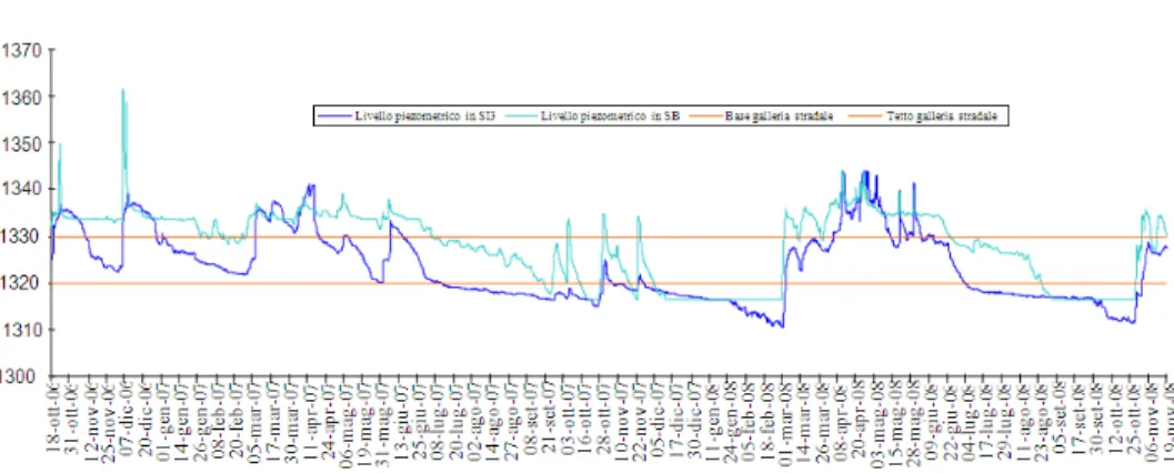
Fig. 15: Variation of piezometric levels in monitoring wells SI3 and SB (Oct. ’06-Nov. ’08)
These new materials form the latest generation of mineral-organic resins: pure single- or dual-component solutions with low viscosity and relatively high reaction rates. These properties make them particularly suitable barriers against abundant water flows. Their single-stage nature means that these solutions are able to penetrate porous media, to reach even low permeability media. There are, for example, products currently on the market that have been widely tested for consolidation and waterproofing of fractured and karstified rock masses. When subjected to a series of water release tests complying with UNI standards, these types of product are completely atoxic and do not release toxic substances to the water, except in very low concentrations that are in any case well below the limits set by the legislation.
Expected arrival times: In order to be able to forecast the arrival time of a potential contaminant flow to the spring, a range of speeds have been considered, inferred from tests carried out on fractured limestone, in the Alpi Liguri, that has a similar hydrogeological structure. To measure the distance between the spring and the overlying aquifer, which is affected by excavation of the road tunnel, the following points were considered: the furthest (900 m) and the nearest (575 m) points of the stretch of tunnel that crosses the carbonate aquifer (254.6 m) and the spring tapping works (60 m long). Based on the estimates, the speeds range from 5×10⁻⁵-2.5×10⁻² m sec−1. Assuming a hydraulic gradient of 0.44 for the area under examination, the respective permeability values for the carbonate mass are found to fall between 2.2×10⁻⁵ m sec−1 and 1.1×10⁻² m sec−1, which is typical of a rock mass with a range of fractured states and related karstification.
For relatively high permeability values, it is possible to hypothesise relatively short arrival times at
the spring for a possible contaminant coming from the carbonate portions involved in the road tunnel consolidation works. Given the well-logging data and the fractured state of the observed carbonate mass, in the study area it is possible to hypothesise permeability of between 10−3 and 10−4 m sec−1 with arrival times of between 7 and 67 days.
Risk of quantitative deterioration: Water level monitoring records for the carbonate aquifer that will be affected by the new tunnel (Fig. 15) show that the excavation will undergo different pressure head conditions. During the winter and late summer the piezometric level of the aquifer will be below the excavation level, while during substantial flows (snow melt or abundant precipitation) the hydraulic head may reach as many as thirty metres above road level.
The route of the new tunnel is at the same altitude and at about 20 m away from the previous excavation; therefore, significant differences between the work under construction and the existing tunnel are not expected. Nevertheless, it was considered necessary to calculate the drainage potential of the new work because, given that the inflow/outflow equilibrium of the hydrogeological structure is fixed, water drawdown may lessen the quantity of water tapped at the spring.
In order to forecast the drawdown that excavation of the new tunnel may cause, thus depriving the spring, model was used. This seems to be the most suitable model for the particular circumstances.
13
Table 9: Proposed threshold values for monitoring the Sorgente di Tenda at the construction stage
Legal limits Recommended Corresponding water-
Parameter (Italian Law D.L. 02.02.01 No.31) Threshold Value cement concentration Turbidity Not required by the legislation, 0.50 NTU ~ 0.005 g L−1
but considered to be below 1 NTU
pH 6.5 < pH < 9.5 9 ~ 0.12 g L−1
Electrical conductivity 2500 μS cm−1 450 μS cm−1 ~ 0.32 g L−1
The risk of impoverishing spring flow will therefore be extremely low, during periods of drought in particular and flow will be scarcely influenced during spring floods that reach values even exceeding 0.3 m3 sec−1. It should be pointed out that the future works will be completely waterproofed.
Monitoring: Given the many problems that have arisen in similar situations, at the expense of local water resources, careful monitoring should be carried out at every stage of the works:
• monitoring before works start
• monitoring during construction
• monitoring after works completion
Always assuming that spring flow rate must be measured continuously during the works and for a long period after their conclusion, the highly important monitoring stage before works start has been carried out by following the behaviour of numerous parameters in different sectors of the area under examination and for a number of years, in order to characterise the aquifer as precisely as possible and to understand hydrodynamic and chemical-physical variations over time and the possible responses to stress of man-made origin. The work has made it possible to formulate numerous considerations of an environmental nature and at the decision stage, will make it possible to take the correct technical decisions so as to prevent the occurrence of public health, economic and strategic problems and should it be necessary, to close the Sorgente di Tenda if the arrival of contaminants is detected.
Monitoring during construction is essential in order to keep a check on water quality at the spring during the various stages of the works. The purpose of the following study was also to identify which parameters, of those with values that are easy to record continuously, would be able to indicate the arrival of undesirable substances at the spring, as a result of consolidation works on the tunnel.
Monitoring during construction is hence of fundamental importance in the prevention of public health emergencies related to this important, valuable water resource. The instruments that are to be installed
at the spring must be able to carry out continuous monitoring of parameters such as turbidity, pH, electrical conductivity and flow rate. For a range of parameters, alarm thresholds have been defined so that when a threshold is crossed the water is immediately sampled, by an automatic sampling machine connected to the recorders, for complete chemical analysis in order to check for the presence of undesirable substances. If the maximum allowed concentration is reached it will be necessary to take immediate steps to stop water input to the aqueduct.
Table 9 shows some threshold values that have been identified for the three parameters (turbidity, pH and electrical conductivity) that are the easiest to determine at a reasonable cost and that give sufficiently valid overall readings as indicators of the potential arrival of undesirable substances at the spring.
The threshold value for turbidity should take account of turbidity occurring in springtime, which is related to snow melt and reaches levels of approx. 60 NTU. Clouding of the water due to low concentration injections of cement solutions, which at other times of the year would be clearly visible, would remain unnoticed in springtime. For this reason, parallel monitoring of a practically constant aquifer parameter, like pH, is proposed. As a matter of fact, slight increases of pH are able to detect the arrival at the spring of solutions with low cement concentrations.
The last parameter to be monitored is specific electrical conductivity. The water from the Sorgente di Tenda never reaches conductivity values that exceed 550 μs cm−1 and peak values are only observed at the time of heavy precipitation or snow melt. Minimum recorded values are always greater than 350 μs cm−1
. The plan is for tunnel excavations to be carried out in the limestone portion during drought periods, when water levels in the aquifer have a lower hydraulic head and hence create fewer difficulties during excavation. These periods coincide with seasons of low rainfall (winter or summer) when water conductivity shows fairly constant values (around 400 μs cm−1
).
characteristics and purpose as monitoring during construction. At this stage it will also be necessary to keep a check on phenomena due to leaching of sulphated water present in the Col di Tenda aquifer, which may affect the injected cement, now-solidified, solutions.
DISCUSSION
This case study presents an infrequently occurring situation. An Alpine massif, where there are already two tunnels (for road and rail traffic) requires further excavation to double the existing heavily trafficked road tunnel link between Italy and France.
The uniqueness of the case is the presence, inside the rail tunnel, of a highly important spring that feeds a very extensive aqueduct system serving 1a00,000 inhabitants of a territory with scarce available water resources for human consumption.
The problem has been tackled before inauguration of the construction site, with a precise prognosis of the hydrogeological scenario based on readings, installation of monitoring wells, continuous level and flow measurements, chemical analysis of the water, tracer tests.
Reconstruction of the scenario has made it possible to provide indications for the new excavation, above all in order to reduce to a minimum the risk of spring contamination caused by percolation of cement and hazardous admixtures.
It has also been possible to estimate the vulnerability of the spring in terms of the requirements of Italian law D.L. 152/2006 regarding protection zones for water intended for human consumption.
REFERENCES
Civita, M., G. Peano and B. Vigna, 1982. La stazione sperimentale della Grotta di Bossea nel quadro delle ricerche idrogeologiche sui sistemi carsici del Monregalese. Mem. Soc. Geol. It., 29: 187-207. Civita, M., M. De Maio and B. Vigna, 1999. Una
metodologia GIS per la valutazione della ricarica attiva degli acquiferi. Atti 3° Convegno Nazionale Sulla Protezione E Gestione Delle Acque Sotterranee I Parma, 1: 1.291-1.303.
Civita, M.V., 2008. An improved method for delineating source protection zones for karst springs based on analysis of recession curve data. Hydrogeol. J., 16: 855-869. DOI: 10.1007/s10040-008-0283-4