Symposium programme
Book of Abstracts
3 Regional Symposium on Landslides
rdin the Adriatic-Balkan Region, Ljubljana
2017
11 - 13 October 2017
3 Regional Symposium on Landslidesrd
in the Adriatic-Balkan Region, Ljubljana
2017
Symposium sponzors
Acknowledgments
The Organizing committee is deeply appreciative of the sponsorships generously provided by the following
companies:
Regional Symposiums on Landslides in the Adriatic-Balkan Region are important meetings of engineers, professionals and researchers in the region. The aim of reducing the risk of landslides is extremely important, and remains a both a decisive directive and challenge in the future. The 3rd ReSyLAB will take place this time in Ljubljana, the capital of Slovenia.
You will be visiting a Central European country where landslides threaten more than one-third of the Slovenian territory, which means some 20 percent of the population is vulnerable. Following the ISDR-ICL Sendai Partnerships 2015–2025 for the Global Promotion of Understanding and Reducing Landslide Disaster Risk and the 2017 Ljubljana Declaration on Landslide Risk Reduc- tion, the symposium will explore possible ways of enhancing cooperation between the landslide science community and the diverse range of stakeholders both in the Adriatic-Balkan Region and around the world.
Over the next few days we hope you will enjoy the numerous opportunities for social and profes- sional interaction with new experts and familiar colleagues and friends. Please take this sympo- sium as an opportunity to visit the photo exhibition of selected images from the WLF4 Landslide Photo Contest and take advantage of our technical program. We will be hosting and presenting four invited lecturers over the course of the symposium. The symposium will be attended by over 60 geoprofessionals, including more than 20 students who are pursuing undergraduate studies in geology and civil engineering. The symposium organisers received 42 abstracts, out of which 38 papers have been accepted for oral presentation. Each paper includes one or more aspects of mapping, investigating, monitoring, analysing or mitigating landslides, as well as case studies on innovative analysis, mitigation techniques and solutions. The symposium will con- clude with two interesting field study tours: “Landslides in the Vipava valley” and the “Potoška planina landslide”.
Our wish is that this 3rd ReSyLAB meets and exceeds the high expectations of all participants in the larger effort to achieve two primary objectives: first, it should contribute to improving research and putting knowledge and experience into practice; and secondly, it should serve to enrich a general understanding of this country, together with its rich historical and cultural back- ground, for all those who are coming to Slovenia for the first time.
Our sincere gratitude goes to all of the sponsors who made the organization of this symposium possible. We appreciate all of the help we have received from members of the International Sci- entific Committee, the Local Organizing Committee, and all of those individuals that expressed their support throughout the organization process.
We wish you a most fruitful and enjoyable 3rd ReSyLAB.
Mateja Jemec Auflič Timotej Verbovšek
Matjaž Mikoš
Chairs of the Organizing Committee
3rd
Regional Symposium on Landslides in the Adriatic-Balkan Region, Ljubljana, Slovenia
Dear participants of the 3
rdReSyLAB 2017,
Contents
Organizing Committee General information Symposium programme
Programme schedule of oral sessions Abstracts
Keynote lectures
1-Mapping and Spatial Analyses 2-Hazard Zoning and Risk
3-Monitoring Techniques and Warning Systems 4-Landslide Mechanics and Simulation Models 5-General Case Studies
6-Remedial Measures and Effects 7-Social, Political and Economic Impact Field study tour, 1. Landslides in Vipava valley Field study tour, 2. Potoška planina landslide Notes
6 8 10 12 14 14 21 25 27 36 42 49 50 58 60 62
Snježana Mihalić Arbanas
Faculty of Mining, Geology and Petroleum Engineering, University of Zagreb, Croatia
Coordinator of ICL ABN Network Željko Arbanas
Faculty of Civil Engineering, University of Rijeka Croatia
Co-Coordinator of ICL ABN Network Biljana Abolmasov
Faculty of Mining and Geology, University of Belgrade, Serbia
Co-Coordinator of ICL ABN Network
Kiril Anguelov
University of Mining and Geology “St. Ivan Rilski”
Sophia, Bulgaria
Miloš Bavec
Gordana Hadzi Niković
Faculty of Mining and Geology, University of Belgrade, Serbia
Adnan Ibrahimović
The Faculty of Mining, Geology and Civil Engineering, University of Tuzla, Bosnia and Herzegovina
Vedran Jagodnik
Faculty of Civil Engineering, University of Rijeka, Croatia
Mateja Jemec Auflič
Geological Survey of Slovenia, Slovenia
Jernej Jež
Geological Survey of Slovenia, Slovenia
Milorad Jovanovsk
iFaculty of Civil Engineering, Ss. Cyril and Methodius University Skopje, Republic of Macedonia
Organizing Committee Organizers
ICL Adriatic-Balkan Network Geological Survey of Slovenia
University of Ljubljana, Faculty of Civil and Geodetic Engineering University of Ljubljana, Faculty of Natural Sciences and Engineering
Under Honorary Patronage of
Ministry of Education, Science and Sport, Slovenia
Chairpersons
Mateja Jemec Auflič Matjaž Mikoš Timotej Verbovšek
International Scientific Committee
Pavle Kalinić
City of Zagreb, OEM - City Office of Emergency Management, Croatia
Marko Komac
Faculty of Civil and Geodetic Engineering, University of Ljubljana, Slovenia
Martin Krkač
Faculty of Mining, Geology and Petroleum Engineering, University of Zagreb, Croatia
Hasan Kulici
Albanian Geological Survey, Albania
Janko Logar
Faculty of Civil and Geodetic Engineering, University of Ljubljana, Slovenia
Matej Maček
Faculty of Civil and Geodetic Engineering, University of Ljubljana, Slovenia
Kenan Mandžić
The Faculty of Mining, Geology and Civil Engineering, University of Tuzla, Bosnia and Herzegovina
Miloš Marjanović
Faculty of Mining and Geology, University of Belgrade, Serbia
Matjaž Mikoš
Faculty of Civil and Geodetic Engineering, University of Ljubljana, Slovenia
Miralem Mulać
City Office of Emergency Management, Bosnia and Herzegovina
Igor Peševski
Faculty of Civil Engineering, Ss. Cyril and Methodius University Skopje, Republic of Macedonia
Tina Peternel
Geological Survey of Slovenia, Slovenia
Ana Petkovšek
Faculty of Civil and Geodetic Engineering, University of Ljubljana, Slovenia
Tomislav Popit
Faculty of Natural Sciences and Engineering, University of Ljubljana, Slovenia
Boštjan Pulko
Faculty of Civil and Geodetic Engineering, University of Ljubljana Slovenia
Zoran Radić
Faculty of Civil Engineering, University of Belgrade, Serbia
Mileva Samardžić-Petrović
Faculty of Mining and Geology, University of Belgrade, Serbia
Kyoji Sassa
Executive Director, International Consortium on Landslides, Japan
Martina Vivoda Prodan
Faculty of Civil Engineering, University of Rijeka, Croatia
Timotej Verbovšek
Faculty of Natural Sciences and Engineering, University of Ljubljana Slovenia
Marjana Zajc
Geological Survey of Slovenia, Slovenia
Sabid Zekan
The Faculty of Mining, Geology and Civil Engineering, University of Tuzla, Bosnia and Herzegovina
Miloš Bavec
Geological Survey of Slovenia, Slovenia
Matjaž Mikoš
Faculty of Civil and Geodetic Engineering, University of Ljubljana, Slovenia
Mateja Jemec Auflič
Geological Survey of Slovenia, Slovenia
Jernej Jež
Geological Survey of Slovenia, Slovenia
Tina Peternel
Geological Survey of Slovenia, Slovenia
Timotej Verbovšek
Faculty of Natural Sciences and Engineering, University of Ljubljana, Slovenia
Tomislav Popit
Faculty of Natural Sciences and Engineering, University of Ljubljana, Slovenia
Local Organizing committee
Official language
The official language of the 3rd Regional symposium on Landslides in the Adriatic-Balkan Region is English.
Photo exhibition
Please take this symposium as an opportunity to visit the photo exhibition of the selected photos from the WLF4 Landslide Photo Contest on the ground floor at the Faculty of Civil and Geodetic Engineering.
Coffee break and lunch
During session breaks, refreshments will be served free of charge to participants wearing symposium identifi- cation badges. Lunches are included in the registration fee and will be served during lunch time.
Information for Speakers
Oral Presentations
All accepted abstracts and full papers will be presented orally. Authors should bring their presentations (in PowerPoint or PDF format) on a USB stick or CD/DVD-ROM, and must upload them to the computer in the section room 30 minutes before the actual time of the session. Symposium staff will assist authors with the loading of the presentation and will transfer the presentation files to the computers in the presentation rooms.
Each presentation should be 12 minutes speech followed by 3 minutes of discussion.
Field study tour
Requirements for participants: there will be approximately two hours of walking at the both field study tours.
Weather-appropriate clothing and sturdy footwear is required. Travel cost and a lunch box are covered by the organizers and symposium sponsors.
Registration FEE
Symposium fee for all participants is 120 EUR, except for students for whom it is 60 EUR. The registration fee includes: symposium material, admission to all scientific sessions, book of abstracts, Proceedings of the 3rd Re- SyLAB, refreshments during coffee breaks and lunches, social event and a field study tours (optional).
General information
Symposium venue,
11 October 2017University of Ljubljana
Kongresni trg 12 SI-1000 Ljubljana Slovenia
Symposium venue,
12 October 2017University of Ljubljana
Faculty of Civil and Geodetic Engineering Jamova cesta 2
SI-1000 Ljubljana Slovenia
Registration Desk
The Registration Desk of the first day of the 3rd ReSyLAB will be located in the Hall of Zbornič- na dvorana in the first floor of University of Ljubljana (entrance from Vegova street).
The Registration Desk of the second day of the 3rd ReSyLAB will be located in the 2nd floor of Faculty of Civil and Geodetic Engineering.
Registration Desk
Side Event
Round Table Discussion
Title: Enhancing cooperation between the landslide science community and end users Date: Wednesday, 11 October 2017, 13:30–15:00
Venue: Zbornična dvorana, University of Ljubljana, Kongresni trg 12, 1000 Ljubljana Organizers
Adriatic-Balkan Network of the International Consortium on Landslides (ICL ABN) Introductory lecture
International and regional cooperation on reducing landslide risk in Italy Veronica Tofani, Department of Earth Sciences, University of Firenze, Italy Moderator
Matjaž Mikoš, Chair of the UNESCO Chair on Water-related Disaster Risk Reduction, Faculty of Civil and Geo- detic Engineering, University of Ljubljana, Slovenia
Invited panelists include landslide scientists from academic and research institutions and civil protection ad- ministration authorities from Bosnia in Hercegovina, Croatia, Serbia and Slovenia. Following the ISDR-ICL Sen- dai Partnerships 2015-2025 for Global Promotion of Understanding and Reducing Landslide Disaster Risk and the 2017 Ljubljana Declaration on Landslide Risk Reduction the Round Table Discussion will explore possible ways of enhancing cooperation between the landslide science community and end users from administrative bodies in BIH, Croatia, Serbia and Slovenia.
The round table discussion will cover the following topics:
(1) Disaster risk factors and scenarios, including emerging disaster risks, in the medium and long term;
(2) Enhance research for local, regional, national applications;
(3) Support actions by local communities and authorities; and
(4) Support decision-making with interaction between policy makers and the scientific community.
The aim of the Round Table Discussion is to debate, with a wider audience, the priorities for future practical applications derived from the scientific results gained in the framework of landslide research in those mem- ber-countries that belong to the ICL Adriatic-Balkan Network: Albania, Bosnia and Herzegovina, Croatia, Slo- venia and Serbia. The discussion among governmental representatives and scientists will be conducted with a view to finding answers to questions related to current and applicable use of geoenvironmental data and infor- mation in systems dealing with land-use planning, civil and environmental protection, and to the development of related necessary legislative documentation (e.g., guidelines, laws).
Social event
Date: Wednesday, 11 October 2017, 18:00
Welcome reception in the Ljubljana City Hall (Mestna hiša).
Participants will also have the opportunity to attend a short guided tour in Ljubljana city centre focusing on natural stone in cultural buildings and monuments.
Symposium programme
Wednesday, 11 October 2017
Venue: Zbornična Dvorana, University of Ljubljana, Kongresni trg 12, 1000 Ljubljana Registration
Opening Ceremony, Keynote speakers
Miloš Bavec – Director of Geological Survey of Slovenia
Maja Makovec Brenčič – Minister of Education, Science and Sport Igor Papič – Rector of University of Ljubljana
Matjaž Mikoš – Vice president of International Consortium of Landslides Snježana Mihalić Arbanas – Coordinator of ICL ABN Network
Veronica Tofani – Landslide monitoring and rapid mapping
Lisa Borgatti – From slow to fast. Modelling, monitoring and mitigating Deep-seated Gravitational Slope Deformations
Miloš Bavec – Recent developments in landslide research in Slovenia 8:30 – 9:30
9:30 – 12:00 Opening Adress
Keynote speakers
Lunch
Round Table Discussion
Enhancing cooperation between the landslide science community and end users Coffee break
Oral Session1 Social event 12:00 – 13:30
13:30 – 15:00 15:00 – 15:30 15:30 – 17:15 18:00
Thursday, 12 October 2017
Venue: Faculty of Civil and Geodetic Engineering, Jamova 2, 1000 Ljubljana, P-II/6, 2nd
floor
Oral Sessions1Symposium conclusions 9:00 – 17:30
17:30 – 18:00
Friday, 13 October 2017
Field study tours (optional)
1. Landslides in Vipava valley
Departure from Faculty of Civil and Geodetic Engineering, Jamova 2, 1000 Ljubljana 2. Potoška planina landslide
Departure from Faculty of Civil and Geodetic Engineering, Jamova 2, 1000 Ljubljana 8:00 – 17:00
8:00 – 15:00
Wednesday, 11 October 2017
Session 1 15:30 - 17:15 Convener(s): Matjaž Mikoš, Snježana Mihalić Arbanas
Keynote lecture: Analysis of Rainfall Preceding Debris Flows on the Smědavská hora Mt., Jizerské hory Mts., Czech Republic
Vít Vilímek, Jana Smolíková, Jan Blahút
Extreme precipitation events and landslides activation in Croatia and Bosnia and Herzegovina Sanja Bernat Gazibara, Krešimir Pavlić, Ivana Vlahek, Hamid Begić, Sabid Zekan,
Martin Krkač, Marin Sečanj, Snježana Mihalić Arbanas
Challenges for operational forecasting of rainfall induced landslides in Slovenia Mateja Jemec Auflič, Jasna Šinigoj, Matija Krivic
Damage caused by landslides and other natural disasters in Slovenia between 1991 and 2008 Matija Zorn, Mauro Hrvatin, Jure Tičar
MyDewetra CapRadNet: the evolution of the DewetraNet platform for hydrometeorological risk management and marine ecosystems monitoring
Miranda Deda, Luca Molini, Paolo Campanella, Paola Tepsich, Antonio Libroia, Marco Massabo, Mateja Jemec Auflič
The role of multisector partnerships in landslide prevention
Špela Kumelj, Tina Peternel, Jernej Jež, Blaž Milanič, Mateja Jemec Auflič 15:30 – 16:00
16:00 – 16:15
16:15 – 16:30 16:30 – 16:45 16:45 – 17:00
17:00 – 17:15
Programme schedule of oral sessions
Thursday 12 October
Session 2 9:00 - 10:45 Convener(s): Biljana Abolmasov, Jernej Jež
Keynote lecture: Towards a pan-European landslide database from the Geological Surveys Gerardo Herrera et al.
Analysis of rock falls on the road section Renke-Zagorje, Slovenia Darja Rozina, Mateja Jemec Auflič, Timotej Verbovšek
Rockfall Risks Management in the Slovenian Road Network Suzana Svetličič
Karst structures in heterogeneous lithological units as a potential geo-engineering hazard factor for mining and civil infrastructures
Željko Pogačnik, Kei Ogata, Gian Andrea Pini, Giorgio Tunis
The use of GPR for determining sheath fold blocks in the heterogeneous horizons of subaquatic gravity flows in W Slovenia – the case of Anhovo
Marjana Zajc, Željko Pogačnik, Andrej Gosar
GPR facies determination – Pusto Brdo - Srebrnjak Hill’s Recent and Hystorical Landslides Željka Sladović
Coffee break 9:00 – 9:30
9:30 – 9:45 9:45 – 10:00 10:00 – 10:15
10:15 – 10:30
10:30 – 10:45 10:45 – 11:15
Combined interpretation of optical and SAR data for landslide mapping Daniel Hölbling, Barbara Friedl, Jirathana Dittrich, Francesca Cigna, Gro Birkefeldt Møller Pedersen
Identification of potentially unstable rock blocks on the road cut in the Krka National park, Croatia Marin Sečanj, Sanja Bernat Gazibara, Snježana Mihalić Arbanas, Martin Krkač, Željko Arbanas, Mariana Martinko
Rockfall monitoring and simulation on a rock slope near Ljig in Serbia Miloš Marjanović, Biljana Abolmasov, Marko Pejić, Snežana Bogdanović, Mileva Samardžić-Petrović
The slow-moving landslides of NW coast of Malta: insights from long-term monitoring and modeling
Stefano Devoto, Matteo Mantovani, Alessandro Pasuto, Mauro Soldati Preliminary results of Selanac debris flow modelling in RAMMS - a case study Jelka Krušić, Katarina Andrejev , Biljana Abolmasov, Miloš Marjanović
Stože landslide triggering simulation using LS-Rapid Jošt Sodnik, Matej Maček, Matjaž Mikoš
Lunch 11:15 – 11:30
11:30 – 11:45
11:45 – 12:00
12:00 – 12:15
12:15 – 12:30 12:30 – 12:45 12:45 – 14:00
Programme schedule of oral sessions
Session 3 11:15 - 12:45 Convener(s): Željko Arbanas, Tina Peternel
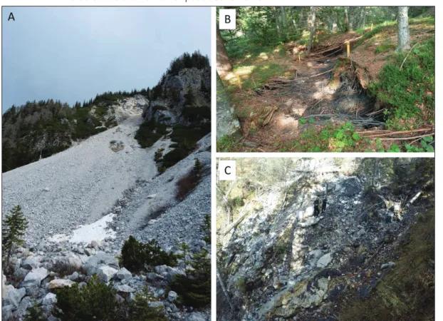
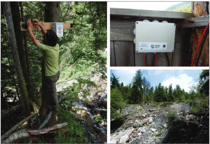
Automated GNSS monitoring of Umka landslide-review of seven years’ experience and results Biljana Abolmasov, Marko Pejić, Mileva Samardžić Petrović, Uroš Đurić, Svetozar Milenković Photogrammetric monitoring of Potoska Planina landslide
Vid Peterman
Observing the surface movement pattern of Potoška planina landslide using geodetic techniques
Tina Peternel, Marko Komac
Tools for the real time visualization and analysis of Ground-based data: application to the monitoring of landslides
Giovanni Nico, Uroš Kostić, Andrea di Pasquale
Visibility analysis for planning terrestrial landslide alert systems with webcams Florian Albrecht, Damian Taferner, Mateja Jemec Auflič, Daniel Hölbling A web service for landslide mapping based on Earth Observation data
Daniel Hölbling, Florian Albrecht, Elisabeth Weinke, Clemens Eisank, Filippo Vecchiotti, Barbara Friedl, Antonia Osberger, Arben Kociu
Coffee break 14:00 – 14:15
14:15 – 14:30 14:30 – 14:45
14:45 – 15:00
15:00 – 15:15 15:15 – 15:30
15:30 – 16:00
Session 4 14:00 - 15:30 Convener(s): Martin Krkač, Mateja Jemec Auflič
Session 5 16:00 - 17:30 Convener(s): Matej Maček, Timotej Verbovšek
Estimation of possible economic losses of large water transportation systems due to landslides, Case studies from Republic of Macedonia
Natasha Nedelkovska, Igor Peshevski, Milorad Jovanovski, Sead Abazi, Bojan Susinov Origin of planation surfaces in the hinterland of Šumljak fossil landslides, Rebrnice (Vipava Valley, SW Slovenia)
Tomislav Popit
Using tree-ring analysis in studies of slope mass movements Andrej Novak, Andrej Šmuc, Ryszard J. Kaczka
The Spatio-Temporal Dynamics of the Ciprnik complex Landslide, Tamar Valley, Julian Alps, Slovenia
Andrej Šmuc, Karolina Janecka, Michal Lempa, Andrej Novak, Ryszard J. Kaczka
The engineering geological - geomechanical properties of soil landslides settlements
"Svrake ", Vogosca, Sarajevo and concept of rehabilitation Hamid Begić
Spatial engineering geological and geotechnical modeling of embankment with RNK - method and stability analyses of waste water treatment facility (UPOV) in Vukovar
Želimir Ortolan, Mensur Mulabdić, Krunoslav Minažek, Jelena Kaluđer, Jelena Matijević, Marko Ortolan
Symposium conclusions 16:00 – 16:15
16:15 – 16:30
16:30 – 16:45 16:45 – 17:00
17:00 – 17:15
17:15 – 17:30
17:30 – 18:00
Programme schedule of oral sessions
Keynote lecture
Landslide monitoring and rapid mapping Abstracts
The work focuses on the application of innovative monitoring techniques to estimate the deforma- tional evolution of the landslide masses for landslide rapid mapping and early warning. In particular it deals with the optimization and validation of the operational protocols for technical and scientific support in areas at risk, and on the definition of rapid procedures for assessing landslide danger and proper managing of emergency situations. This is achieved by the synergistic use of rapid mobile units for localized survey based on terrestrial, marine and airborne sensors.
Research activities were focused on satellite remote sensing radar data for the identification (de- tection and mapping), analysis and monitoring of gravitational slope deformations in order to define proper risk scenarios and to support the management of their evolutionary phases. The activities are also aimed at improving the satellite surveillance system based on all the EO data (radar, multi- and hyperspectral) already available from several satellites (ERS, ENVISAT, RADARSAT, COSMO-SkyMed).
Such integrated system will be designed for the identification, rapid mapping, monitoring and analy- sis of risk scenarios. Under the European program, called Copernicus, the recent launch of the SEN- TINEL-1 satellite (able to provide information in continuity with those from ERS and ENVISAT) offers new opportunities for monitoring the Earth's surface and for the evaluation of ground movements.
Such activities are possible at different scales of investigation and at different geological contexts us- ing advanced processing techniques and interpretation of interferometric data derived from satellite images acquired by old and new systems. In order to optimize this satellite surveillance procedure during forecast, emergency and post-emergency cycles, activities were concentrated on satellite radar interferometric techniques and their integration with ground-based data for:
• monitoring the instability of slopes aimed at the detection of the deformation trends, through the study of temporal series of the interferometric SAR data for early warning purposes.
• Rapid mapping of landslide based on slope displacement patterns.
Nicola Casagli
(1), Veronica Tofani(1)(1) Department of Earth Sciences, University of Florence, Italy ([email protected])
From slow to fast. Modelling, monitoring and mitigating Deep-seated Gravitational Slope Deformations
Keynote lecture
Deep-seated Gravitational Slope Deformations (DGSDs) can involve entire high-relief mountain chain sectors. They have been described as giant, non-catastrophic landslides, or as intermediate class of slope instability processes lying between gravitational movements and gravitational tecton- ics phenomena. Even if they typically display very slow and discontinuous displacements (0.4–5 mm y−1), they can evolve in catastrophic events and may represent themselves the predisposing factor of eventually smaller but rapid secondary landslides, such as rock falls and rock avalanches. Detailed investigations are still lacking in the field of lateral spreads and related landslides in weak rock masses and more research is required for hazard and risk assessment and mitigation.
Several causal factors control the initiation and the evolution of these phenomena: predisposing factors are related to the structural setting of the slope, the rock mass characteristics and the valley geometry, whereas preparatory factor include glaciation and deglaciation effects, topographic stresses, changes in valley geometry, uplift rate and distribution, regional seismicity. Prolonged rainfalls and earthquakes are recognized as triggering factors. As far as predisposing factors are concerned, these large-scale slope pro- cesses occur in moderately strong and anisotropic rock masses and are thus controlled by structural fea- tures such as bedding planes, foliation and fractures. In fact, DGSDs are described in different geological contexts: sackungen or rock flows typically occur in schistose metamorphic rocks, whereas lateral spreading normally develops in the presence of rigid blocks overlying a plastic sequence and is more common where antiformal structures are associated with extensional regimes and thrust structures. Where lateral rock spreading phenomena involve brittle rock units overlying a more ductile substratum, associated secondary instabilities such as rock falls, topples and slides may occur at the edges of the plateau, while earth slides and/or flows can impact the underlying terrains. Several examples have been described in Europe (Maltese archipelago, Slovakia), in the Alps (Cinque Torri Group) and particularly in the Apennines of Italy, where historical villages were often built on the top of rocky plateaux (Orvieto, Civita di Bagnoregio, Pitigliano).
On the 27th of February 2014 a large landslide endangered the historical centre of San Leo, a medi- eval town built on the top of a calcarenitic slab in Val Marecchia (northern Italy). A volume of about 330,000 m3 of rock detached from the north-eastern side of the plateau, resulting in the evacuation of several houses, a school and a police station. Before the failure, severe undermining of the rock slab was noticed, as a result of the progressive removal of the clay shales. As this erosional process was thought to be associated with surface runoff and shallow landslides occurring in small-scale catchments at the base of the cliff, countermeasures such as earthen dams and retaining walls founded on piles were adopted in the last decades to avoid further slope instability, together with extensive bolting of the rock face.
In this context, numerical modelling, together with field investigations, laboratory tests and moni- toring, were used to delineate possible predisposing factors and related failure mechanisms. In par- ticular, the back analysis of the San Leo 2014 landslide complements the understanding of secondary instability phenomena developing at the edges of the plateau and the recognition of the mechanisms leading to catastrophic failure, which are acting on the slope in the medium- to long-term.
The overall results provide the data to plan effective and low impact surveys and monitoring activ- ities in target portions of the unstable slope. In fact, in this outstanding cultural landscape, the con- servation of the natural asset has to be ensured together with the safe access to the area by means of adequate landslide risk mitigation measures with low environmental and visual impacts.
Lisa Borgatti
(1)(1) Department of Civil, Chemical, Environmental and Materials Engineering - DICAM, University of Bologna, Italy ([email protected])
Keynote lecture
Recent developments in landslide research in Slovenia
The main reason for the relative frequency of landslides in Slovenia lies in the complex geolog- ical structure of the territory and the fact that a large part of the country experiences significant tectonic stress, together with frequent heavy rainfall and occasional strong earthquakes. As the population grows, settlements and infrastructure are continuously spreading into areas of in- creased hazard for landsliding. As a result, more than 10,000 landslides have been recorded by the Administration of the Republic Slovenia for Civil Protection and Disaster Relief (ACPDR) and the Geological Survey of Slovenia (GeoZS) over the past three decades, which translates into an average landslide density of 0.5 landslides per km². Also, a number of strategies and measures designed to deal with this increased risk have been developed, ranging from simple risk avoid- ance to construction projects for mitigation of landslides whose volume exceeds one million m3.
In the field of regulation, which will control planning and construction in the landslide risk areas, Slovenian legislation remains insufficient, even given that the government officially adopted the EU Flood Directive in 2007. Legislative acts deal largely with remediation issues instead of pre- vention measures; and are mainly divided into prevention, emergency protective measures, and permanent measures adopted in the process of remediation. The current protection strategy against landslides is part of The Waters Act (Official Gazette of RS, 2002), which follows the Wa- ter Frame Directive of the European Parliament and Council 2000/60/EC, where developments in landslide-prone areas are specified primarily in terms of adverse effects of water – mean- while, spatial planning in areas that could be the source of or increase the risk of landslide is completely overlooked.
Despite the inadequate legislation, research institutions continue to make determined steps toward reducing the risk of landslides. In general, broader landslide risk studies are performed in the frame of three types of funding schemes. The first are scientific research programs funded by the Slovenian Research Agency that are aimed at gathering new, fundamental knowledge.
These studies further support the basis for the second type of studies, which are various applied research projects supported mainly by the relevant ministries and in some cases, by the lo- cal communities. The European Commission financing mechanisms also offer opportunities for high-quality research to advance landslide risk reduction through different project calls, either scientific or applicative. Other possibilities for funding of landslide research exist, but here we focus mainly on those that are the most common and have particular impact here in Slovenia.
Many studies have been undertaken in the last two decades related to landslide prevention on the regional and local level. One of the first steps towards an effective prevention strategy for tackling landslides was the initiation of a central landslide database. At the conclusion of the first phase of compiling the National Landslide Database (May 2005) there were more than 6,600 registered landslides. Based on this landslide database a Landslide Susceptibility Map of Slovenia at a scale of 1:250,000 was created. Likewise, a Debris-flow Susceptibility Map for Slovenia at a scale of 1:250,000 was also made available, as well a Rockfall Susceptibility Map (1:250,000),
Mateja Jemec Auflič
(1), Matjaž Mikoš
(2), Timotej Verbovšek
(3), Miloš Bavec(1)(1) Geological Surcey of Slovenia, Slovenia ([email protected])
(2) Faculty of Civil and Geodetic Engineering, University of Ljubljana, Slovenia (3) Faculty of Natural Sciences and Engineering, University of Ljubljana, Slovenia
tion lives in landslide-prone areas – which is a clear indication that better spatial and urban planning is definitively required, both at the national as well as local level. Therefore, the next logical step was the development of a meth- odology model for landslide susceptibility on the municipal level, which was undertaken as a pilot project – “Elab- oration of spatial database and web information system on geohazards (slope mass movements, erosion and snow avalanches)”, funded by the Ministry of the Environment and Spatial Planning. Within this project, susceptibility maps and web applications were elaborated at a scale of 1:25,000 for 14 Slovenian municipalities (out of a possible 212). Project products (maps, geodatabase, web application) serve as directly applicable warning maps and as a basis for spatial planning at the municipal and regional level.
The fact is that we cannot avoid landslides entirely – but we could minimise their impact on settlements and so- ciety as a whole. The ACPDR is fully aware of this matter. ACPDR therefore initiated the development of a system designed to accurately assess and forecast landslide probability (MASPREM) in 2013. A near real-time system for forecasting landslide probability is currently operational and is in the validation phase.
Through the implementation of several research programmes, our capacity to use remote sensing data (InSAR, PSInASR, UAV photogrammetry, and TLS) in the identification, observation and monitoring of unstable slopes has advanced significantly. The application of knowledge and innovative techniques aimed at reducing landslide risk has also been developed through several EU projects. Among others, the Slovenian landslide research community has participated as a partner in Project TERRAFIRMA, ChlimChAlp, AdaptAlp, SEDALP, Start_it_up, Safeland, Pangeo, IngeoClouds, CapRadNet and the ongoing Recall initiatives. The primary objective of these projects is to identify landslide-prone areas and apply new monitoring technologies. Knowledge dissemination is particularly important, which also includes student education – two Slovenian ICL members are active in teaching, presenting the out- comes of the research projects and work of the ICL to students of civil engineering and geology.
All of the Slovenian members of the ICL, comprising the Geological Survey of Slovenia (GeoZS), the Faculty of Civil and Geodetic Engineering (FGG), and the Faculty of Natural Sciences and Engineering (NTF), have been involved in the ICL’s activities for several years now: (in FGG since 2008, GeoZS since 2011, and NTF since 2016), and in the Adriatic Balkan Network since 2012. This year, GeoZS and University of Ljubljana, Faculty of Civil and Geodetic Engineering, were both awarded World Centre of Excellence (WCoE) in Landslide Risk Reduction, and joined the group of 20 World Centres of Excellence for the period 2017–2020. All three members have had active or ongoing IPL projects in the frame of ICL activities. The larger overall objective of our research follows the Sendai Framework on Disaster Risk Reduction 2015–2030, which consists primarily in strengthening efforts to reduce losses related to landslide hazards by applying new, advanced technologies for landslide identification/zonation and monitoring.
Towards a pan-European landslide database from the Geological Surveys
Keynote lecture
Gerardo Herrera
(1,2), Eleftheria Poyiadji
(1,3), Rosa María Mateos
(1,2),Juan Carlos García- Dava- lillo
(1,2), Gilles Grandjean
(1,4), Raluca Maftei
(1,5), Tatiana- Constantina Filipciuc
(1,5), Mateja Jemec Auflič
(1,6), Jernej Jež
(1,6), Laszlo Podolszki
(1,7), Alessandro Trigila
(1,8), Carla Iadanza
(8), Hugo Raet- zo
(1, 9), Arben Kociu
(1,10), Maria Przyłucka
(1,11), Marcin Kułak
(1,11), Michael Sheehy
(1,12), Xavier M.
Pellicer
(1,12), Charise McKeown
(1, 12), Graham Ryan
(1,12), Veronika Kopackova
(1,13), Michaela Frei
(1,14),Dirk Kuhn
(1,15), Reginald L. Hermanns
(1,16), Niki Koulermou
(1,17), Colby A. Smith
(1,18), Mats Engdahl
(1,18),Pere Buxó Pagespetit
(1,19), Marta Gonzalez
(1,19), Claire Dashwood
(1,20), Helen Reeves
(1,20), Francesca Cigna
(1,20), Pavel Liščák
(1,21), Peter Pauditš
(1,21), Vidas Mikulėnas
(1,22), Vedad Demir
(1,23), Margus Raha
(1,24), Lídia Quental
(1,25), Cvjetko Sandić
(1,26), Balazs Fusi
(1,27), Odd Andre Jensen
(28), Jan Walstra
(1,29),Philippe Steeghs
(1, 30), Aleksandra Gulan
(1,31), Hjördis Löfroth
(1,32), Boris Malyuk
(1,33)(1) Earth Observation and Geohazards Expert Group (EOEG), EuroGeoSurveys, the Geological Surveys of Europe (2) Geohazards InSAR laboratory and modeling group, Geohazards Unit, Geological Survey of Spain (IGME), Spain
(3) Institute of Geology and Mineral Exploration, Greece, Engineering Geology Department, Greece (4) BRGM, Risk and Prevention Division, Orleans, France
(5) Geological Institute of Romania, Romania (6) Geological Survey of Slovenia, Slovenia (7) Croatian Geological Survey, Croatia (8) ISPRA, Geological Survey of Italy, Italy
(9) Swiss Federal Office for the Environment, Switzerland (10) Geological Survey of Austria, Austria
(11) Polish Geological Institute, Poland (12) Geological Survey of Ireland, Ireland (13) Czech Geological Survey, Czech Republic
(14) Federal Institute for Geosciences and Natural Resources (BGR), Germany (16) Geological Survey of Norway, Norway
(17) Cyprus Geological Survey, Cyprus (18) Geological Survey of Sweden, Sweden
(19) Institut Cartogràfic i Geològic de Catalunya, Spain (20) British Geological Survey, United Kingdom (21) Geological Survey of Slovakia, Slovakia (22) Geological Survey of Lithuania, Lithuania
(23) Federalni zavod za geologiju, Bosnia and Hercegovina (24) Geological Survey of Estonia, Estonia
(25) Laboratorio Nacional de Energia e Geologia, Portugal
(26) Geological Survey of the Republic of Srpska – Bosnia and Herzegovina (27) Geological Survey of Hungary, Hungary
(28) Norwegian Water and energy Directorate of Norway, Norway (29) Geological Survey of Belgium, Belgium
(30) Geological Survey of the Netherlands, Netherlands (31) Geological Survey of Serbia, Serbia
(32) Swedish Geotechnical Institute, Sweden
(33) Ukrainian State Geological Research Institute, Ukraine
Landslides are one of the most widespread geohazards in Europe, producing significant social and economic impacts. Rapid population growth in urban areas throughout many countries in Europe and potential extreme climate scenarios can considerably increase landslide risk in the near future.
In the framework of the Geological Surveys of Europe (EGS), the Earth Observation and Geohazards Expert Group (EOEG) has carried out a survey regarding how geohazards, in particular landslides, are integrated into urban and land-use planning. This survey reveals heterogeneous policies across national borders, 17% of the countries do not include geohazards in their legislation and half of them have no official methodological guides for hazard assessment. Additionally, there is a lack of knowledge about real social impacts of geohazards in many of the countries, although geohazards have a significant effect on their national economies. This overview stresses the need for a com- mon legislative framework and homogenization of the national legislations, including the guidelines, which adopt the principles applicable to the geohazards management and explain the process to be followed in the production of hazard documentation. This is especially relevant in case of landslide and subsidence hazards. Although they are very recurrent in all European countries, there are no common guidelines and practices as defined on the assessment and management of flood risk (Di- rective 2007/60/EC). With this long-term goal in mind, we analysed the landslide databases from the Geological Surveys of Europe focusing on their interoperability and completeness. From the 849543 landslide records from the Geological Surveys 36% are slides, 10% falls, 20% flows, 11% complex slides and 24% remain either unclassified or correspond to another typology. A landslide density map was produced (LANDEN map) showing, for the first time, 210544 km2 of landslide prone areas and 23681 administrative areas where the Geological Surveys from Europe have recorded landslides. The comparison of this map with the European Landslide Susceptibility Map (ELSUS 1000 v1) is success- ful for most of the territory (69.7%) showing certain variability between countries. This comparison also permitted to identify 0.98 Mkm2 (28.9%) of landslide susceptible areas without records from the Geological Surveys, which have been used to evaluate the landslide database (LDBs) completeness.
The estimated completeness of the LDBs from the Geological Surveys is 17%, varying between 1%
and 55%. This variability is due to the different landslide strategies adopted by each country. In some of them, landslide mapping is systematic, others only record damaging landslides, whereas in others countries landslides maps are only available for certain regions or local areas. Moreover, in most of the countries LDBs from the Geological Surveys co-exist with others owned by a large variety of pub- lic institutions producing LDBs at variable scales and formats. Hence, a greater coordination effort should be made by all the institutions working in landslides mapping to increase data integration and harmonization. Moreover, EOEG compiled for the first time in 2015, the annual report on damaging landslides with data taken from Geological Surveys. The idea behind this initiative is to provide an an- nual landslide report, based on a pan-European unified database, which can provide information on the spatial distribution, the triggering events, the types of landslides, and their social and economic impact, making this geo-hazard visible to policy makers, decision makers and European citizens in order to reduce the impact of landslide disasters.
Analysis of Rainfall Preceding Debris Flows on the Smědavská hora Mt., Jizerské hory Mts., Czech Republic
Keynote lecture
In August 2010 extreme rainfall affected the north of the Czech Republic and caused regional floods and landslides. Three torrential debris flows originated in the Jizerské hory Mts., close to Bílý Potok on the north slope of the Smědavská hora Mt. The rainfall situation which triggered the debris flow was analysed and compared with the rainfall situation in 1958 when a debris flow occurred in the same area.
The rainfall data were obtained from rain gauges of the Czech Hydrometeorological Institute. Four rain gauges were chosen close to the Smědavská hora Mt. with data of:
a) daily amounts between 1983 and 2013;
b) hourly amounts and c) 10-minute intensity from the specific period. The data for the 1958 event were available from three different rain gauges (only daily amounts). The data series were not com- plete so linear regression was applied to interpolate them.
A number of analyses were carried out including daily rainfall, two-day/three-day moving values, antecedent precipitation index (API) of 5/10/30 days, 10-minute intensity and hourly amounts. The trigger factor of the debris flow in the study area was also investigated. It was determined that for the triggering of debris flows both high API values as well as high intensity-short duration rainfall is needed. It was proven that in cases of solely high API indices or high intensity-short duration rainfalls no debris flows were initiated.
Vít Vilímek
(1), Jana Smolíková
(1), Jan Blahút
(2)(1) Department of Physical Geography and Geoecology, Faculty of Science, Charles University, Prague, Czech Republic ([email protected])
(2) Department of Engineering Geology, Institute of Rock Structure and Mechanics, Czech Academy of Sciences, Czech Republic
Combined interpretation of optical and SAR data for landslide mapping
1-Mapping and Spatial Analyses
The wide range of Earth Observation (EO) data from different sensors and the increasing temporal and spatial resolution offer new possibilities to derive valuable landslide information. Optical satellite images have been mainly employed for mapping event-triggered landslides in combination with mor- phological properties derived from digital elevation models (DEMs); traditionally by visual interpreta- tion and manual digitization, more recently by employing semi-automated image analysis methods, either pixel-based or object-based. Since landslides usually appear brighter than their immediate surroundings on optical images due to the exposure of bare ground, mainly the spectral properties of optical images are used for landslide recognition. Multi-temporal Synthetic Aperture Radar (SAR) interferometry and methods such as Persistent Scatterer Interferometry (PSI) and Small Baseline Sub- set (SB or SBAS) have been primarily used for identifying slow moving landslides and for quantifying movement rates, but only few studies combined semi-automated mapping results based on both data sources to produce added value information. Landslide mapping using object-based image anal- ysis (OBIA) based on SAR data solely is challenging. The combination of post-event optical and SAR data for detecting and delineating event-based landslides using OBIA seems to be more promising, since the properties from both data sources can be exploited. Advantages of SAR sensors over optical sensors are their ability to acquire data during day and night and to penetrate clouds. This can be beneficial for rapid mapping of event landslides that are triggered by intense or prolonged rainfall.
We present three case studies addressing the combination of optical and SAR data for an integrated landslide mapping. For the first test site, located in northern Italy, SPOT-5 data was used together with a DEM to map landslides with OBIA. On the other hand, deformation rates were derived using the PSI technique and ENVISAT and RADARSAT-1 data stacks. The combined interpretation of the landslide boundaries detected through OBIA with radar measures (i.e. surface displacements ob- tained from PSI) facilitated the updating of the pre-existing landslide maps. The second example com- prises the investigation of typhoon-triggered landslides and debris flows in the Khaosiung county, southern Taiwan. Through the integration of multispectral information (SPOT-5), SAR intensity values (TerraSAR-X) and DEM derivatives in an OBIA environment, landslides could be examined in a more efficient way as opposed to relying on single data sources only. The multi-data analysis was especially useful for delineating single, large-scale landslides. Finally, a third case study was performed in the Öræfajökull area in south-east Iceland. We investigated how SAR coherence information and optical imagery could be synergistically used to assist landslide mapping in this glacio-volcanic landscape.
The combined interpretation of different types of EO data offers remarkable possibilities for im- proved landslide mapping, even if existing (OBIA) approaches still need to be optimized. Such inte- grated analysis of optical and SAR data can be useful to fully exploit the potential of EO data from different sensors for landslide mapping and monitoring with the aim to provide useful information for supporting disaster management.
Daniel Hölbling
(1), Barbara Friedl
(1), Jirathana Dittrich
(1), Francesca Cigna
(2),Gro Birkefeldt Møller Pedersen
(3)(1) Department of Geoinformatics - Z_GIS, University of Salzburg, Salzburg, Austria ([email protected])
(2) Scientific Research Unit, Italian Space Agency (ASI), Rome, Italy (3) Institute of Earth Sciences, University of Iceland, Reykjavik, Iceland
Spatial engineering-geological and/or geotechnical modeling of embankment with RNK-method and stability analyses of waste water treatment facility (UPOV) in Vukovar
1-Mapping and Spatial Analyses
The RNK-method, or the Reference Level of Correlation method (RLC-method), represents a pro- cedure for spatial engineering-geological and/or geotechnical modelling, that was tested on many landslides in Croatia. The engineering-geological/geotechnical correlation column can be established in zones of limited extent (sometimes occupying tens of km2) using one or several characteristic layers, one of which is selected as the reference layer. In the established correlation column, a soil liquid limit and plasticity index appear as useful indicators of the peak friction angle, full-softening friction angle and residual friction angle for coherent soils and soft rock formations. As a rule, max- imum plasticity index values correspond to the minimum values of such friction angles. It offers the opportunity for correct spatial engineering-geological/geotechnical modelling with differentiation of minimum shear strength zones (the weakest link in the "geotechnical chain of shear strength"), zones of different hydraulic conductivities, and zones of various degrees of natural compaction.
The engineering-geological/geotechnical correlation column of an analyzed area is the „key“ for the interpretation of the overall geotechnical/geological relationships in a required number of selected profiles. Such features ensure the highest level of correctness in the resolution of slope stability prob- lems and provide all relevant information needed to develop a series of representative geotechnical profiles for 2D and 3D stability analyses.
Results obtained by the application of the RNK-method will be shown on the potentially unstable area of waste water treatment facility (UPOV) in Vukovar. The correspondig engineering-geological map and geotechnical correlation column will be shown also.
This project and its location is of special interest due to presence of loess soils, vicinity of the river, relatively high seismic activity and warning examples of instability in the broader area of similar con- ditions.
Želimir Ortolan
(1), Mensur Mulabdić
(1), Krunoslav Minažek(1), Jelena Kaluđer
(1), Jelena Matijević
(1),Marko Ortolan
(2)(1) Faculty of Civil Engineering, J. J. Strossmayer University of Osijek, Croatia ([email protected]) (2) Croatian waters, Legal entity for water management, Sector for EU co-financed projects, Croatia
Extreme precipitation events and landslide activation in Croatia and Bosnia and Herzegovina
1-Mapping and Spatial Analyses
Landslides are common features in Croatia and in Bosnia and Herzegovina and the most frequent triggering factors are precipitation (rainfall and snow melting) and man-made activities. Landslide ac- tivation for a given precipitation event can be analysed based on the database of precipitation events that resulted (or did not result) in landslides in the study area and the neighbouring regions. The main problem with the current practice of landslide risk management in both countries is the lack of a suitable landslide inventories and historical databases of landslide events. This paper focuses on an- alysing the relationship between extreme precipitation contiditons and rainfall-triggered landslides in the NW Croatia in 2013 and in Bosnia and Herzegovina in 2014. During winter and spring of 2013, extreme weather conditions (re)activated unusually high numbers of shallow landslides in NW Cro- atia (approximately 10,500 km2 or 18.5% of the land area). In this period, the Croatian National Pro- tection and Rescue Directorate (DUZS) recorded more than 900 landslide events. The largest number of landslides was recorded in the area of three counties: Krapina-Zagorje County, Varaždin County and the City of Zagreb. To investigate the rainfall conditions that resulted in floods and landslides in Croatia in 2013, precipitation measurements obtained by three meteorological stations were used – Zagreb Grič, Bednja and Zabok. Based on the available historical data for the Zagreb Grič weather station, analysis of the 3-month period from January to March showed that cumulative precipitation for the analysed period in 2013 has the highest value ever measured. Analysis of the historical pre- cipitation record in the City of Zagreb further indicates that the high intensity precipitation in period from January to March 2013 is unique in the last 150 years. In May 2014 the low-pressure cyclone Tamara (Yvette) affected a large area of Southeastern and Central Europe, causing floods and land- slides with the greatest damages in Bosnia and Herzegovina. The most affected areas include basins of the Bosna, Vrbas, Drina, Sana and Sava rivers at the territory of 73 municipalities in the Bosnia and Herzegovina (approximately 10,000 km2 or 20% of the land area). As a result of the flooding, 21 peo- ple died, more than 66,000 people were evacuated from their homes, more than 60,000 residential houses and building were damaged or destroyed, more than 7100 landslides were (re)activated and the total damage is estimated at more than a two billion euros. To investigate the rainfall conditions that resulted in floods and landslides in Bosnia and Herzegovina in May 2014, rainfall measurements obtained by three meteorological stations were used – Sarajevo, Tuzla and Zenica. Analysis of cumu- lative monthly rainfalls at Sarajevo meteorological station for January-May 2014 showed that during April and May cumulative monthly rainfall was 50-55% higher than the average monthly values for the same period from 1949 to 2015. Cumulative monthly rainfall at Sarajevo meteorological station in April 2014 (148.5 mm) is the highest amount ever measured since 1949, while monthly rainfall in May 2014 (186.2 mm) was exceeded only one time in last 66 years with a maximum monthly value of 203.3 mm in May 1978. A comparison between plotted precipitation conditions that caused land- slides in NW Croatia in 2013 and Bosnia and Herzegovina in 2014 with published global ID thresholds shows that precipitation conditions exceeded the threshold curves proposed by other authors. Anal- ysis of extreme precipitation conditions showed that both the short- and long-duration rainfalls were responsible for the large number of landslide initiations in the NW Croatia and Bosnia and Herzegov- ina. Understanding the relationship between landslides, precipitation conditions and climate change is therefore crucially important in planning a proactive approach in hazard and risk management.
Sanja Bernat Gazibara
(1), Krešimir Pavlić
(1), Ivana Vlahek
(1), Hamid Begić
(2),Sabid Zekan
(3), Martin Krkač
(1), Marin Sečanj
(1), Snježana Mihalić Arbanas
(1)(1) Faculty of Mining, Geology and Petroleum Engineering, University of Zagreb, Croatia ([email protected]) (2) The Federal Institute for Geology, Bosnia and Herzegovina
(3) Faculty of Mining, Geology and Civil Engineering, University of Tuzla, Bosnia and Herzegovina
Landslide Hazard zonation along the Milot–Kukësi motorway in Albania
1-Mapping and Spatial Analyses
This paper briefly describes the landslide hazard zone along the Milot–Kukësi motorway in Albania.
According to landslide zonation information, many critical areas in terms of slope instability are to be found along the motorway. The studied area is located in the northern part of Albania. It represents a mountainous zone, which is comprised of various lithological units such as soil, molasses' rocks of clay- stone-siltstone-sandstone, limestone, melange formation-blocks in the matrix, basalts and ultrabasic rocks. It should be noted that the motorway crosses an area that is quite complex in terms of morpho- logical and geological structure, characterized by steep slopes, fractured and highly- weathered rocks. As a result, intensive excavations were carried out during the construction of the motorway on the hills and mountain slopes that compromised their stability. Thus both during and after rainfall, several landslides have occurred along the side slopes of the motorway. As a result an engineering geological mapping was performed along this zone in 2015 and 2016 at a scale of 1:10,000 where many of the landslides sites are defined. The mapping indicates that their activity is closely related to geomorphology, lith- ological formations, tectonic effects, geotechnical properties of the bedrocks and soils, precipitation events and manmade actions and interventions. In addition, a geotechnical zonation map at a scale of 1:10,000 was compiled from the analysis and interpretation of the field and laboratory work, in which several engineering geological zones and sites were identified as being homogeneous in terms of the above-mentioned geo-factors. Also, lot of mass movements that occur along the motorway’s side slopes were mapped using the results of the fieldwork. According to Cruden and Varnes (1996), debris flows, rocks slides, toppling-rock falls and earth slides constitute the major natural hazards in the study area.
Furthermore, the studied area was analysed in terms of landslide hazard zonation, which should prove helpful for engineering measurements used to mitigate landslide disasters and in planning development activities. This involves spatial analysis of landslide-prone areas along the Milot–Kukësi motorway using high-resolution satellite data along with field data in a GIS environment. Heuristic approaches have been applied in the assigning of ranks and weights preparation, which is based entirely on field observations and expert a priori knowledge. The analysis includes various terrain parameters like lithology, geological structures, slope, geomorphology and land use/land cover in order to identify landslide hazard zones in the study area. These classes were assigned corresponding rating values as attribute information in the GIS environment. Each class within a thematic layer was assigned an ordinal rating from 1 to 5 according to their assumed or expected importance in inducing slope instability. A summary of these attribute values was then multiplied by the corresponding weights to generate the different degrees of landslide hazard. A landslide hazard zonation map was prepared showing five different zones, ranging from very low-hazard zone to very high-hazard zone, which is essential in carrying out faster and safer mitigation programs, as well as for planning future development. The aim of the present work was to determine hazard zones along the main motorway in Albania, which is central to minimizing associated risks.
Finally, the presented study shows that by performing geotechnical mapping at a scale of 1:10,000 and by analysing geotechnical data using the GIS method, it is possible to determine the hazardous areas made dangerous by the geofactors discussed above. These areas require particular attention in the selection and design of effective mitigation measures, which in turn reflect the need for a clear understanding of the conditions and processes that induced the mass movements and created unstable areas.
Ylber Muceku
(1), Olgert Jaupaj
(2), Olivier Lateltin
(3)(1) Institute of Geosciences, Polytechnics University of Tirana, Albania ([email protected]) (2) Albanian Geological Survey, Albania
(3) Swiss Geological Survey, Switzerland
2-Hazard Zoning and Risk
Analysis of rock falls on the road section Renke-Zagorje, Slovenia
The regional road section between the towns of Litija and Zagorje (especially the eastern part between Renke and Zagorje) is one of the most endangered sections in Slovenia considering the amount of traffic and the unfavorable geological conditions. The broader area belongs to the Sava folds, an intensively uplifted area composed of Permo-Carboniferous classic rocks, Triassic and Lower Jurassic carbonates, Upper Cretaceous flysch and Quaternary deposits. On the approximately 15 km long road section, Middle and Upper Triassic limestones prevail, forming very steep slopes. Due to tectonic fracturing, carbonates are intensively fractured and many rock falls are trigged on the road due to these unfa- vorable geological conditions and steep slopes. Although numerous mitigation measures have been performed (concrete walls, steel wire net barriers, crib walls, berms, gabions, road galleries), the road is still prone to rock falls, indicated by impacts on the asphalt, road fence, car accidents and appear- ance of rocks on the road. In order to identify the most prone sections a methodology combining field and computer modeling was applied. Rock fall modeling was performed in RocScience RocFall 5.0 software for 14 profiles along the road section to simulate the energy, velocity and bounce height of the falling rocks. Data of the locations of road accidents related to rock falls were collected from the local Police and Road maintenance service and a map of frequency of rock fall events and existing prevention measures on the selected road section was prepared in GIS. Modeling was performed by simulating limestone and dolomite rock falls of 100 rocks of an average size of 35x30x50 cm, al- though much larger blocks were observed. Results from field observations show that approximately half of the road section has protection measures, but some of the net barriers are damaged and are not cleaned regularly. Road maintenance service has reported 269 rock falls in 2015 and the police 35 accidents for the past three years, but not all accidents were reported. For unprotected sections, rock fall simulations have confirmed the greatest impact kinetic energies (maximum 297 kJ) for most dam- aged sections. After these analyses the road was classified into four rock fall hazard classes where the first class (no hazard) presents only 1.5% of the road section. Over 90% of the road section is categorized into high hazard classes 3 and 4, which indicates that this road section needs to be treat- ed as one of the most dangerous road section in the country. Recently, several mitigation measures (new steel wire net barriers) have been constructed in 2016 on the most critical section and these measures will continue in the future along the other locations.
Darja Rozina
(1), Mateja Jemec Auflič
(2), Timotej Verbovšek (1)(1) Faculty of Natural Sciences and Engineering, University of Ljubljana, Slovenia ([email protected])
(2) Geological Survey of Slovenia, Slovenia
2-Hazard Zoning and Risk
Identification of potentially unstable rock blocks on the road cut in the Krka National park, Croatia
Rock fall is a common phenomenon on the steep slopes along the Croatian part of the Adriatic Coast which can lead to risk of death and injury to people, damage to buildings and infrastructure. The aim of this paper is to present visual and semi-automatic identification of potential rock fall source areas and unstable rock blocks on the road cut in the National park Krka, Croatia. Identification was conducted by traditional surveying and by interpretation of digital surface models derived from the high-resolution point cloud data obtained with the terrestrial laser scanning and unmanned aircraft system (TLS and UAS). The investigated road cut is located on the right bank of the river Krka, on the frequent county road which is the only connection between the villages of Kistanje and Oklaj. Local residents and visitors of National park Krka are endangered by rock falls due to the location of the road, just beside the steep slope of the surrounding hill. The investigated road cut and the slope above it are located in the core of the anticline which is built of Eocene-Oligocene Conglomerates and Breccia (Promina Deposits). Complexity of the geological-structural setting, caused by faulting and folding in the area, led to the formation of numerous discontinuities in rock mass as well as unstable rock blocks with unfavourable orientation and a potential to turn in to rock falls. The investi- gated road cut and slope above it are around 900 m long, with the maximum height of around 60 m. To identify potential rock fall source areas and unstable rock blocks, detailed mapping of discontinuities and rock blocks was performed based on remote sensing and traditional survey. From the data col- lected with the terrestrial laser scanning and the unmanned aircraft system, a point cloud with the spacing between points of 1 cm was created and visualized in a CAD software. Spatial data, which was contained in the point cloud, was used to construct a digital surface model in the Split-FX software.
To determine geometrical features of rock mass, such as slope and discontinuity orientation, spacing and roughness of joints etc., different semi-automatic and automatic features of Split-FX software were used. Discontinuity sets with unfavourable orientation in respect to the slope and road cut were determined, grouped and visualized. With the spatial kinematic analysis, potential rock fall source ar- eas and the probable instability mechanism were determined, while potentially unstable rock blocks were manually singled out. Identified rock fall source areas, unstable rock blocks and probable in- stability mechanisms on the investigated road cut and slopes above, present the input data for risk reduction by an efficient design of countermeasures
.
Marin Sečanj
(1), Sanja Bernat Gazibara
(1), Snježana Mihalić Arbanas
(1), Martin Krkač
(1),Željko Arbanas
(2), Mariana Martinko
(1)(1) Faculty of Mining, Geology and Petroleum Engineering, University of Zagreb, Croatia ([email protected] )
(2) Faculty of Civil Engineering, University of Rijeka, Croatia
3-Monitoring Techniques and Warning Systems
The use of GPR for determining sheath fold blocks in the heterogeneous horizons of subaquatic gravity flows in W Slovenia – the case of Anhovo
Within heterogeneous lithological horizons, the determination of sedimentary anisotropic bodies with the two-dimensional extension of more than 10 times their thickness provides the possibility of a suitable interpretation of the causes of damage as well as a definition of pillars of safety for the con- struction / reconstruction of an infrastructure. Due to their synsedimentary and structural-diagenetic changes, the spatial position of such bodies conditions the orientation of the local compressive stress and the hydrostatic pressure in the hinterland, which are the greatest contributors to the formation of sliding surfaces and consequently geomechanical deformations of vast dimensions (slips, slides, etc.).
Heterogeneous rock masses, which appear in the W and NW Slovenia in the municipalities of Kanal ob Soči, Tolmin and Kobarid, represent Cretaceous and Paleocene subaquatic gravitational flows, the so-called MTD - mass transport deposits, characterized by strong deformations of the substratum.
These sequences are characterized by three geomechanically anisotropic units, which are the litho- logical horizons U1 and U2 (composed of calcareous breccia with oversized carbonate olistoliths and bedded siliciclastic-carbonate and marly olistoliths); horizons U3 and U4 (graded calcareous breccia, calcirudite and laminated calcarenite); and unit U5 (in the form of massive / laminated marlstone).
The paper presents the use of the Ground Penetrating Radar (GPR) method for the determination of a covered layered block within the U2 unit. The GPR results were integrated with the interpretation of partial outcrops as well as the lithostratigraphic map of the area. Due to its non-invasive nature and efficiency, the application of GPR has been rapidly increasing in various geological studies and has been successfully used in several landslide and geohazard investigations.
As our research area consists of heterogeneous materials with high signal attenuation, a low frequen- cy 50 MHz rough terrain antenna (RTA) was used to ensure the sufficient depth penetration needed for this study. With the use of the low frequency GPR and field mapping we were able to differentiate between different rock layers within a heterogeneous block as well as determine the presence of dis- continuities already proven capable of becoming sliding surfaces and producing landslides.
The combination of such investigative methods for the detection of layered bodies has shown to be very successful. Supported by adequate field data, a systematic use of the GPR method can be effec- tive in defining potential / latently unstable rock masses, and can therefore be used for determining the scope of intervention needed for the construction / reconstruction of infrastructure.
Marjana Zajc
(1), Željko Pogačnik
(2), Andrej Gosar
(1,3)(1) Faculty of Natural Sciences and Engineering, University of Ljubljana, Slovenia ([email protected])
(2) Georudeko, geology, mining and ecology d.o.o, Slovenia
(3) Seismology and Geology Office, Slovenian Environment Agency, Slovenia