The predominantly quantitative physical habitat characterization method was part of the Environmental Monitoring and Assessment Program Western Pilot Study conducted in the western United States from 2000 to 2004. I must thank the staff of the Department of Environmental Quality for the chance to accompany their field survey team.
Challenges of Assessing the Hydromorphological Condition of Running Waters
Therefore, is it more appropriate to refer to the conditions that would exist under current watershed conditions but in the absence of human disturbance along the channel and adjacent river corridor" (Rinaldi et al describe "the assessment and identification of aquatic habitats mainly intact" based on "the conditions that characterized the rivers and streams of Austria before the systematic measures of canalization (late 19th to mid-20th century) and the construction of large hydroelectric stations and chains of dams .Member States have agreed to continue the exercise to fill the gaps in the work achieved to date" (Water Information System for Europe 2008).
Aim and Structure of the Thesis
Selection of European Hydromorphological Inventory and Assessment Methods
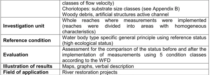
Methods designed to fulfil the requirements of the Water Framework Directive
Since the EU member states are obliged to meet the requirements of the Water Framework Directive to achieve the predefined targets (see 3.1. The European Water Framework Directive), each country must design river assessment methods based on the guidelines of the Water Framework Directive. The method is designed to fit the requirements of the Water Framework Directive, but it is not exclusive to this area of application.
The European Water Framework Directive
Purpose
The new directives of the European Union significantly influence the national legislation of the member states, also in the area of the protection and the sustainable use of natural resources.
Environmental Objectives
Measures and Procedures
- River Basin Districts
- Characterization of Surface Water Body Types
- Type-specific Reference Conditions for Surface Water Body Types
- Protected Areas
- Pressures and their Impacts
- Surface Water Status
- Monitoring Programmes
- Classification of Ecological Status and Ecological Potential
- Programmes of Measures
- River Basin Management Plans
- Commission Report
Member States must prepare a map for each river basin showing the ecological status using the correct color code (European Commission 2000). Member States must draw up river basin plans for each river basin district and publish them within nine years of the date of entry into force of the Water Framework Directive.
The Austrian Water Act and the European Water Framework Directive
- Regulation on Objectives for Quality Elements according to the WFD
- Regulation on Monitoring the Conditions of Water Bodies
- Investigation of the Hydromorphological Status Quo of Austrian Water Bodies
- Manual for Hydromorphological Investigation of the Status of Running Waters
- Parameter Groups
- Evaluation of the High Hydromorphological Status
- Designation of the Good Hydromorphological Status
- Identification and Designation of Heavily Modified and Artificial Water Bodies
- Evaluation of Artificial and Heavily Modified Water Bodies - Definition of the
- Guidance for the Evaluation of Heavily Modified Water Bodies
The evaluation of the ecological status of water bodies is regulated in the Qualitätszielverordnung (see 3.2.1). Selection of metrics (combinations of metrics) needed to achieve good ecological potential” (translated from Eberstaller et al. 2009).
Assessment of Surface Waters in the USA
Wadeable Streams Assessment
The National Rivers and Streams Assessment (NRSA)
Environmental Monitoring and Assessment Program Western Pilot Study
- Physical Habitat Stressors
- Reference Conditions
- Extent of Resource - Sampling Sites
Estimating the relative importance of potential stressors in those assemblages based on direct measurements of their chemical, biological, and physical habitat” (Stoddard et al. 2005). Riparian Disturbance - “the vulnerability of the stream network to potentially harmful human activities increases with the proximity of these activities to the streams themselves.
Approach
Characterization Survey Methods
NÖMORPH – Ecomorphological Mapping of Selected Running Waters in
- Background, Tasks and Aims
- Characterization
- Evaluation
- Used Forms
Integration of the data in the Wasserdatenverbund (WDV - an information system that registers, manages and evaluates the water data of Lower Austria). The reference conditions are defined using the River Type Region and the Morphological River Type (cf freiland Umweltconsulting 2001). M Water body of the Limestone-Fore-Alps (Gewässer der Kalkvoralpen) N Water body of the high Kalkhochalpen (Gewässer der Kalkhochalpen) O Water body of the Grauwackenzone (Gewässer der Grauwackenzone).
The morphological type of the river is also described with the help of 5 summary parameters (see also 6 reference conditions and results).
Physical Habitat Characterization
- Stream Discharge
- Evaluation
- Used Forms
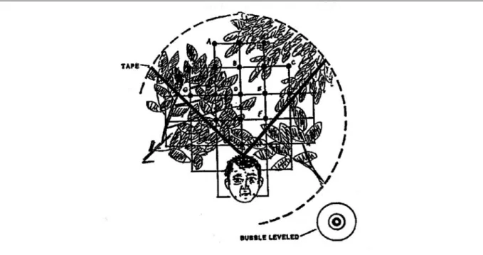
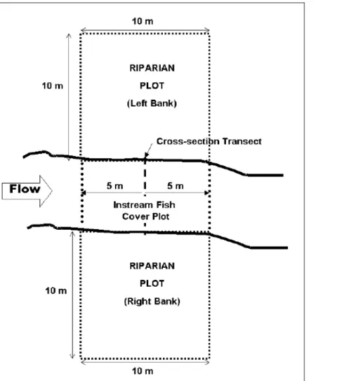
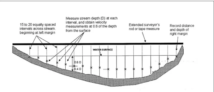
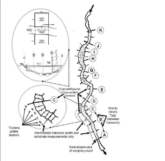
The location and size class estimation of the substrate particles (see appendix B for substrate size class codes) are performed on the left channel margin and at positions and 100% of the distance across the wet channel (see Figure 6 and appendix C). Bank height is measured from the level of the stream's wetted edge (see Figure 10 and Figure 11). The percentage of channel margin that is constrained is estimated for the entire sample range.
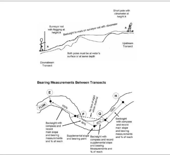
The required information is the average flow velocity in the channel and the cross-sectional area of the flow.
Comparison NÖMORPH - Physical Habitat Characterization
- Goals of the Surveys
- Mapped and Evaluated Criteria and Parameters
- Field Work
- Evaluation
- Illustration and Documentation of the Results
Each of the 5 individual summary parameters is evaluated using 4 main water body status classes and 3 intermediate status classes. The total reach condition is the average of the condition of all 5 individual summary parameters (cf. freiland Umweltconsulting 2001). The state of 5 individual summary parameters was presented with the help of tables and a verbal description.
The Western Pilot Study (EMAP-W) of the Environmental Monitoring and Assessment Program presented the results of the Physical Habitat Characterization using maps, graphs, tables and verbal descriptions.
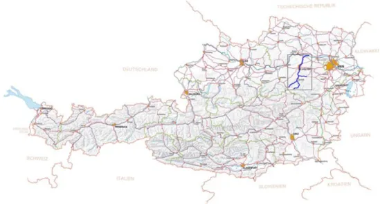
Traisen
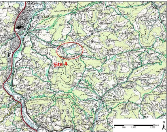
During the preparation phase of the thesis, it became clear to focus on one river system in order to get a consistent picture after the evaluation and analysis of the data and the methods. The most important decision criteria were on the one hand to get an overview of the diversity of the Traisen river system regarding geology, altitude, morphological river types, valley forms, stream orders and human changes. On the other hand, the survey regions did not have to be too remote and moreover fordable since the field work and the transport of the equipment was done by only one person.
Of particular interest was the applicability of the methods for the assessment of residual water stretches.
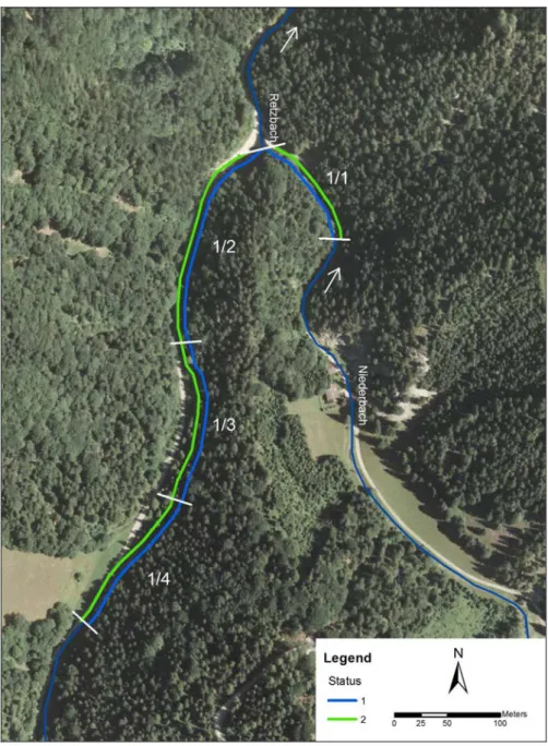
Retzbach (Site 1)
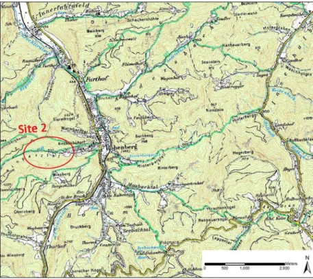
Steinpartztalbach (Site 2)
Although the river bed along the sample stretch is sporadically affected by human changes, such as small and small bridges, it mainly has an almost natural character.
Ramsaubach (Site 3)
Kreisbach (Site 4)
This section of the thesis describes the reference conditions for the 4 study localities based on the river type regions and the morphological river types. Data have been calculated and processed using the Microsoft Excel program for each of the 16 reaches of the 4 study sites. The results are illustrated using tables and figures, generated with a GIS application, showing whole range averages, range percentages and condition classes.
For each sampled reach, a recapitulation presentation of the conclusions and results based on the 5 summary parameters of the NÖMORPH method is attached to demonstrate the agreement between the results of the methods used (see also APPENDIX B. Estimated parameters of the NÖMORPH method and physical habitat characterization).
Retzbach (Site 1)
On the sample it reaches the morphological type Retzbach and Niederbach is limited, which means that the slope is steep and the lateral dynamic development is limited due to the conditions in the rock (limited bed).
Results: NÖMORPH
The illustration shows the results of the overall evaluation of the NÖMORPH survey for both banks using the transformed figures of the Water Framework Directive. The right bank at range 1/1 (Niederbach) and the left bank of range 1/2-1/4 are in worse condition than the other banks of the range. The main reason for this is the heavy influence of the gravel roads that run directly along the rivers through the narrow valley shape.
The transformed figures in the WFD represent the same conclusion, although the additional information from the intermediate classes is lost due to the transformation.
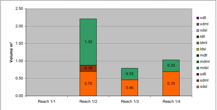
Results: Physical Habitat Characterization
- Reach 1/1
- Reach 1/2
- Reach 1/3
- Reach 1/4
The gravel road has brought great inconvenience to the right bank and the adjacent area. The typical features of the coast and the coastal zone are greatly changed due to the escarpment and the gravel road. The left bank of the stretch is heavily impacted and altered due to the gravel road.
The typical characteristics of the coastal zone have been changed and the vegetation cover is significantly disturbed.
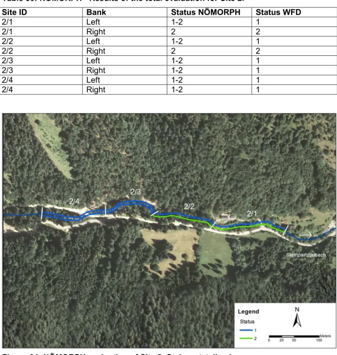
Steinpartztalbach (Site 2)
Results: NÖMORPH
Summary parameters are presented in detail using the results of the physical habitat characterization - see summary presentation of conclusions and results attached to the presentation of the results of physical habitat characterization for the individual samples. The adjusted figures in the water framework directive show that the entire site has a high ecological status in terms of morphology. According to the NÖMORPH results, no reach has a status better than 1-2, mainly due to human impacts (dirt road, parking lot, riprap, logging) on banks, slopes and the surrounding vegetation (see Table 29).
Results: Physical Habitat Characterization
- Reach 2/1
- Reach 2/2
- Reach 2/3
- Reach 2/4
The vegetation cover of the surrounding area is severely damaged, cleared plots (see Figure 74) and non-native species appear. The surrounding vegetation is severely damaged or absent, non-native plant species are present (see Figure 80). The vegetation cover of the river bank is severely damaged, occasionally non-native species are present.
The surrounding vegetation cover is slightly disturbed (see Figure 98), non-native species are present.
Ramsaubach (Site 3)
Results: NÖMORPH
The illustration shows the results of the total assessment of the NÖMORPH survey for both banks using the transformed figures of the Water Framework Directive. In area 3, the same procedures of survey methods for morphological assessment were carried out as for the other sites. The composite parameters that were in the worst condition are the geometry and fluidity of the channel, the banks or slopes and the surrounding vegetation.
Condition class 2 for the entire site is the result of the adjusted figures from the WFD.
Results: Physical Habitat Characterization
- Reach 3/1
- Reach 3/2
- Reach 3/3
- Reach 3/4
The characteristics of the left bank and the riparian zone are greatly changed, non-native species are present (see Table 36). Since the channel was dry during the field study (see Figure 113), the estimation was performed using an imaginary mean discharge. The surrounding plant cover is disturbed or absent, invasive plant species are frequent.
The vegetation of the area is highly disturbed or absent, invasive plant species predominate.
Kreisbach (Site 4)
Results: NÖMORPH
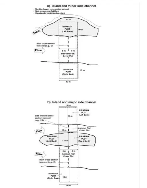
Reach 4/1 is located upstream of the mouth of the Münichwaldgraben which is a left tributary of the Kreisbach. The ecological status of this stretch is high according to the adapted figures of the DKU. In the surveyed area, human impacts have been mitigated to a certain degree due to the cutting of rivers at the bottom of the valley and the riparian vegetation.
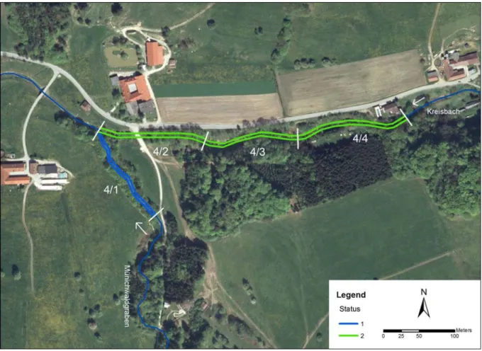
Results: Physical Habitat Characterization
- Reach 4/1
- Reach 4/2
The vegetation cover of the surrounding area has been greatly reduced due to settlement and agricultural use (see Figure 143). The surrounding vegetation is disturbed by the house, agricultural use and the road (see Figure 144). Looking up: Downstream of the bridge, the riverbed is paved with huge boulders overgrown with filamentous algae.
Except for filamentous algae covering the river bed downstream from the bridge, there is almost no fish cover.
Analysis of Correspondences and Differences between the NÖMORPH method and
Conclusion
NÖMORPH
Channel Geometry and Flowability
Riverbed
Connectivity Water - Land
Banks / Riparian Zone
Vegetation Surroundings
Physical Habitat Characterization
Channel/Riparian Cross-Section
Thalweg Profile
Riparian "Legacy" Trees and Invasive Alien Plants
Slope and Bearing
Stream Discharge
Channel Constraint
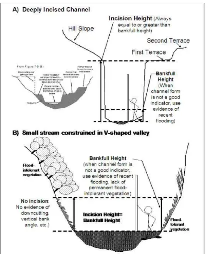
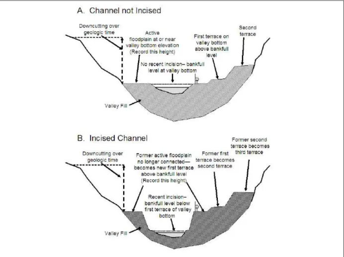
Torrent Evidence Assessment