K
BULLETIN OF THE SERBIAN GEOGRAPHICAL SOCIETY
2013.
XCIII-
. 4
YEAR 2013 TOME XCIII - N 4
riginal Scientific papers UDC:551.585(497.11)
DOI: 10.2298/GSGD1304083B
THE CLIMATE OF MONTENEGRO: MODIFICATORS AND TYPES – PART ONE
DRAGAN BURIĆ1*,VLADAN DUCIĆ2,JOVAN MIHAJLOVIĆ2
1Hydrometeorological Service of Montenegro, IV proleterske 19, Podgorica, Montenegro 2University of Belgrade – Faculty of Geography, Studentski trg 3/3, Belgrade, Serbia
Abstract: The aim of this study is to point out the basic climate modificators and types in Montenegro. Rarely could you find such a small area with more climate types and several subtypes and varieties as it is the case here. In the Part one of the study the most important climate modificators in Montenegro have been discussed, such as: mathematical – geographical position, relief dissection, atmospheric circulation and the Adriatic Sea. Atlantic and Mediterranean aquatories and Eurasian landmass play an important part in climate modification in the area of Montenegro. These vast areas represent the source of atmospheric action centres and air masses.
Key words: climate, modificators, types, Köppen, Montenegro.
Introduction
Montenegro is the country of diversity in all aspects, including climate. There is a real ''climate archipelago'' here where Mediterranean and sub-Mediterranean climate types change into temperate continental, continental, sub-Alpine and Alpine climate type. This is the direct consequence of the geographical position, relief, dissection, movement and confrontation of air masses with different physical characteristics, vicinity of the sea, terrain types and other factors.
Climate is the basic physical component of geographic environment which affects other elements: soil formation and texture, water abundance on the land, relief forms (fluvial, karst, aeolian and glacial), biodiversity, etc. Considering that the weather and climate are significant determinants of the whole human life, this study tries to give the basis for further research within other sciences and economic activities-waterpower, engineering, tourism, agriculture, energetics, spatial planning and other activities important for the development of some places in Montenegro as a whole.
Database and research methodology
Hungarian Weather Service developed two software packages for homogeneity and extrapolation research of meteorological data series, MASH and MISH methods. Original versions of both software packages are modified (Szentimrey, 2003; Szentimrey, Bihari, 2007), and the final versions were presented by the authors within the training called ''Application of climatological methods for interpolation and homogeneity'', which was held from 2 February to 5 February in 2010 in Budapest. Having tested several methods for the
purpose of uniformity, World Meteorological Organization (W ) suggested that MASH v3.02 and MISH v1.02 should be used.
Both methods were used in this research. These methods use Kriging algorithms for interpolation of the missing value is estimated in grids of 100 x 100 m according to the database obtained from all neighbouring stations. Both air temperature data and precipitation amount data taken from 10 main stations and 13 climatological stations were synthesized in the final analysis. Climate types extracted according to the data taken from the last climatological standard period (1961-1990), and extreme values of temperature and precipitation were given for almost the whole period of instrumental observations in Montenegro (1951-2010). Locations of whole weather stations included in this analysis are shown in Figure 1.
Ж К ш Н ш .Н К К 41.8 42.0 42.2 42.4 42.6 42.8 43.0 43.2 43.4 43.6
18.2 18.4 18.6 18.8 19.0 19.2 19.4 19.6 19.8 20.0 20.2 20.4
К ш
. (λ)
ш
(
φ
)
(784)
(784 m) Н
(1450) (647) (944) (49) (33) (3,6) (5,7) (5,4) (10) (691) (1012) (606) (2) (937) (640) (53) (695) (1) (1017) (933) (833) (14)
Figure 1. Locations and altitude of weather stations included in the analysis
Besides general scientific methods (analysis and synthesis), Walter Method has been used in the research procedure. The main characteristic of this method is a specific relationship between temperature and precipitation curves.
Basic Climate Modificators of Montenegro
The climate of a certain place or region is affected by numerous factors. Climate factors modify solar or mathematical climate and turn it into real (physical) climate. They can be divided into three basic groups (Milosavljević M., 1990):
1. Astronomical climate factors are: Earth’s rotation and revolution, that is, the change of the angle at which the sun rays hit the parallel during the day and a year.
2. There are numerous geographical factors: latitude, influence of water objects (oceans, seas and lakes), relief characteristics, soil type, human activities – construction of settlements, accumulations, change of plant cover.
3. Meteorological climate factors: global circulation of the atmosphere, that is, characteristics and transformations of air masses, action centres – baric systems, air composition – water vapour amount, CO2, aerosols (dust, soot and ashes particles).
centres and relief. The others modify local climate and cause the formation of microclimate within the mesoclimate – micro relief, terrain type, vegetation type, soil type, etc.
Latitude
Climate is the word derived from Ancient Greek ’’klima’’, meaning inclination, that is the angle of incidence of sunrays (Dukić D., 1999). In other words, the insolation intensity, therefore the outgoing longwave radiation, that is, surface warming rate and as well as the warming rate of the air above the surface depend, above all, upon the size of the angle of incidence of sunrays. The bigger the angle is, the more intensive the warming. If the angle of incidence is smaller, the same beam of rays will light up and warm bigger surface so, quite logically, there will be less warming. Consequently, warming intensities lie in an inverse proportion with the sunlit surfaces.
On the basis of what is said above, it can be concluded that the data about Sun height above the horizon and the length of the daylight generally represent a index of a certain place or region. The angle of incidence changes during the day and year. It is the consequence of the rotation, revolution and spheroid shape of the Earth, obliquity of the ecliptic in relation to the Sun’s equator (23033') and the orbital axis inclination toward the Earth’s orbital plane (66033'). These are the primary factors that cause an unequal distribution of light and heat of the Earth’s surface.
The value of the angle (γ) of incidence of Sun rays on the parallel is calculated by the formula (Penzar et al., 1996):
ω δ ϕ δ ϕ
γ =sin sin cos cos cos
sin ⋅ + ⋅ ⋅
ϕ - latitude;
δ - declination, i.e. the angular height of the Earth above or below the Sun (celestial) equator plane. The values of the declination for each day in the year and certain location can be found in astronomical tables. Declination ranges from ± 23027’. The highest value is at noon local time during the summer solstice, δ = 23027’.
ω – solar hour angle. At noon at true solar time1ω = 0, and it increases 150 each hour.
The difference between the northernmost (43032') and southernmost (41051') point is 1041', which means that the mean parallel of the field to which the territory of Montenegro belongs is φ = 42°41’30”N. On that parallel, at noon local time, applying the above formula, during the summer solstice, sunrays fall at the angle of 70°45’30” (900 -42°41’30”+23027’), while during the winter solstice that angle is 23°51’30” (900 -42°41’30”-23027’). The height of the Sun at noon above the horizon of the mean parallel during the equinox (spring and autumn) is 47°18’30”. In the latter mean point (42°41’30”N), the longest daylight lasts for 15 hours and 20 minutes (21 June), the shortest is during the winter solstice (21 December), 9 hours, while the time interval between the sunrise and sunset at the beginning of spring and autumn is about 12 hours.
The influence of the angle of incidence of sunrays, that is the influence of latitude on the heating rate is well explained by the Lambert Law, which says: heating intensity on horizontal surface of 1 cm2 is proportional to the sine of an angle at which sunrays fall on that surface, and it is consequently proportional to the cosine of latitude (Ducić V., Anđelković G., 2006).
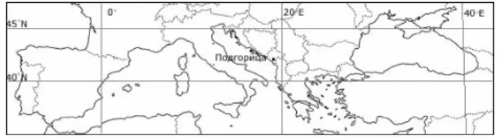
Montenegro is located south from 45th parallel (Figure 2), that is, in the southern part of the north climatic temperate zone. Thanks to that, there is a normal shift of night and daylight, and this region gets moderate amount of heat. Mathematical-geographical position
and the fact that this region represents the baric deformation field, as well as the vicinity of the sea and a considerable dissection of relief are primary factors of climate formation in Montenegro.
Figure 2. Geographical position of Montenegro in the Mediterranean
According to the angle of incidence of sunrays, it can be said that it is particularly large during the summer, which causes high heating intensity on the surface, as well as heating intensity oh the air above. There is a significant heating intensity of the surface in the midseason and it is not insignificant in the winter, either.
It should be emphasized that the heating rate of the surface and, thus of the air above it, doesn’t depend only upon the angle of incidence of sunrays and the length of insolation, as well as upon latitude. The influence of relief (the height above the sea level, exposition and terrain tilt), cloudiness, air translucency, the amount of water vapour and other factors which have a direct or indirect influence on the heating condition of the surface and air isn’t irrelevant, either.
Adriatic Sea
Vast aquatories of the Adriatic and Mediterranean Sea, as well as Eurasian landmass play a great part in climate modification of Montenegro. These vast areas represent the original source of atmospheric and air mass action centres. The Atlantic and the Mediterranean Sea represent also an extremely important source of humidity. The Alps and Dinarides hinder the movement of air masses from the west toward the east and from the Mediterranean toward the north. Among geographical factors, the nearest aquatories – the Adriatic Sea and Skadar Lake, relief and the general terrain type play an important part in Montenegro climate. Rivers and other lakes have, spatially, an insignificant influence on most climate elements. Their influence is visible only in the close littoral zone.
The Adriatic is a warm sea. Maximum water temperatures are recorded in August, and minimum in January. During the summer months the southern Adriatic’s surface water temperature reaches 280C. In the coastal areas, in Budva and Herceg Novi, the average water temperature ranges from 250C in August to 130C in February.
Besides the geographical position, the warm eastern Adriatic current, which comes from the Mediterranean Sea through the Strait of Otranto and moves along the coast with the average speed of about 7 km per day, has an influence on the Adriatic’s water temperature (Radojičić B., 1996).
Due to different physical characteristics, the Adriatic Sea and the surrounding landmass get warm and cool at different speeds. The specific heat capacity of water is significantly bigger than of land. Sea water is partly diathermal and, finally, convective water currents have a significant importance in thermal processes. From these reasons, the influence of insolation on the Adriatic’s water is recorded up to 20 m during a day, that is, up to 70 m during a year. During the summer the Adriatic accumulates about 199 250 /cm2 of heat2. The same heat energy transmits back during the cold half of a year. The thin
surface layer of the land is the most heated one during the insolation – (the so-called) absorption active layer. The transmition of heat to the deeper layers of the land is slow, only from one particle to another. The data analysis obtained from the weather stations in Montenegro where the soil temperature is measured shows that the temperature variations of the soil are recorded up to 50-60 cm in average during a day, that is up to 10-12 m depth during a year (the data obtained by the Fourier heat equation). In an average year, the amount of accumulated heat is about 9702 /cm2, which is 20.6 times less heat than the heat accumulated by the Adriatic.
The Adriatic Sea is heated slowly and weakly in the warmer part of a year but has a significantly bigger heat capacity than the land of Montenegro. It also gets colder more slowly than the land in the winter. That’s why the Adriatic accumulates more heat in the summer than the land. Heat accumulated by the land radiates from the Earth until the midwinter time and therefore minimum temperatures of the surface land layers are recorded in January. The sea water records a heat loss almost from the beginning of the spring. Therefore, minimum temperatures of the Adriatic’s surface water are recorded from the end of February to the beginning of March. From these reasons, the sea is warmer in the winter and colder in the summer than the land. These differences in the heat condition of the surface have a big influence on the heat condition of the air. The air above the land is much warmer than the air above the sea surface in summer in the same latitude. It’s the other way round in the winter. That way, the Adriatic Sea, particularly in the narrow coasted part of the land, becomes a significant climate regulator soothing winter cold and summer heat (Burić D. et al., 2007).
The Mediterranean Sea and its inner Adriatic Sea are a significant source of humidity. Air masses coming from the southern quadrant and passing over this vast aquatory get moisture and bring a great amount of precipitation to the major part of Montenegro, particularly to mountainous hinterland of Montenegro littoral. Crkvice (937 m) located on the slopes of Orjen Mountain, most probably the wettest place in Europe3, receives nearly 5 m of rainfall in an average and in rainy years even over 8000 mm.
Relief
The relief is one of the significant climatic factors, especially if it is dissected, as in Montenegro (Figure 3). The main characteristic of the relief in Montenegro is a sudden altitude change at small distances. The relief influences the climate by its macro and meso forms. The mountains and ravines, as macro forms, have a multiple influence on climate: direction of extending, altitude, dissection, exposition, etc. Special climate characteristics come from river valleys and saddles in mountain systems. The direction of extending of mountain ranges has the biggest influence on the climate in Montenegro, as well as the dissection of relief and altitude. Other relief factors have less influence, i.e. microclimatic (Burić D. et al., 2007).
The altitude difference between the lowest point (0 m, the Adriatic Sea) and the highest one (Zla Kolata peak, Prokletije mountains) is 2534 m. With altitude increase the air temperature drops. The values of temperature gradient depend on the current synoptic situation. In higher regions, at the condensation level, the frequency and the precipitation amount is greater. The height of condensation level rises from the south to the north.
3 Specific discharge within the drainage basin of the Norwegian river Norddalselva is 188 l/s/km2, a Europe
maximum. According to this and other data and using the appropriate formulas, it is estimated that the precipitation
Figure 3. Three-dimensional image of the relief (3D model) in Montenegro (Burić D. et al., 2007)
In other words, the precipitation amount rises on the mountains near the sea with altitude increase up to about 1100-1150 m, and then drops. On the mountains far away from the sea, the precipitation amount is rising with altitude increase up to about 1500-1600 m, and then drops. The length and the intensity of insolation, as well as outgoing radiation, depend on the relief. The southern slopes of hills receive the highest amounts of heat while other expositions receive smaller amounts.
Air circulation
Montenegro is located in temperate latitudes where the weather is mostly due to a shift in air masses. The shift is a part of general and regional atmospheric circulation, that is, by the large-scale vortices- cyclones and anticyclones. These factors, besides the latitude, relief and the Adriatic (Mediterranean) represent the most important factors which influence the weather and climate in Montenegro.
General atmospheric circulation causes a continuous zone distribution of air pressure. Montenegro is located between two permanent active and action atmospheric centres which have dynamic origins – the Azores High (area of high air pressure in subtropical latitudes) and the Icelandic Low (area of low air pressure in subpolar latitudes). This position of Montenegro causes intensive circulation of air masses over the country, that is, the exchange of tropical air from low latitudes and polar air from high latitudes.
Unequal heating of vast landmasses and water bodies causes the development of seasonal action centres. Montenegro is located among such baric centres of the atmosphere. In eastern, northern and central parts of Eurasia the temperature drops down to 500C below zero. The long-lasting stability of the atmosphere and the coldness cause the development of the Siberian High. The ridge of this anticyclone stretches far westward and south-westward. In that period of the year air pressure over the warm Atlantic is low. Montenegro is then under the influence of the Icelandic Low. In the summer, due to the movement of the subtropical ridge of high pressure northward and the cooling influence of the Atlantic, the Azores High dominates. Both during the summer and winter, due to these differences in distribution of air pressure, Montenegro is alternatively affected by the Atlantic and Eurasian landmass.
nice then and the stability of the atmosphere may last for many days. In the summer, the Mediterranean is under the influence of the Azores High which causes long-lasting weather stability. The weather and climate in Montenegro is also affected by the warm air streams rich with desert dust from North Africa.
According to these facts, the Icelandic and Mediterranean Lows, as well as the cyclones which develop in the Gulf of Genoa have the greatest influence on the weather in Montenegro. In the summer the Azores High, in the winter the Siberian High and the anticyclones over Central and East Europe and over North Africa affect the weather in Montenegro, too. The centre of Icelandic Low is usually over the North Sea or Norwegian Sea. It usually reaches Montenegro with its south-western periphery and then the strong south-western high altitude streams develop. In such synoptic situations a long-lasting rainfall occurs- 4 to 6 days.
The Mediterranean Low has a seasonal character. To be more precise, these are the sequences and series of depressions coming from the west, most often over the Bay of Biscay and the Garonna Valley and move forward to the Gulf of Lion and to the Ligurian Sea. The cyclones in the Mediterranean usually come from the well known area of cyclogenesis in North Africa (Algeria and Tunis) and they develop under the influence of the big Atlas mountain range.The track of the cyclone divides into two parts in the Ligurian Sea and in the Gulf of Genoa. One part moves southward toward the Tyrrhenian Sea. A bigger number of cyclones from the Ligurian Sea keep moving over Lombardy to the northern Adriatic. In the Gulf of Rijeka this track divides into three parts. The weather conditions in Montenegro, particularly in the southern region are influenced by the track moving along the southern Adriatic – Vd track, according to Van Bebber (Milosavljević M., 1972, pp. 187). It should be pointed out that, according to the movement patterns, cyclones are characteristic for the southern Adriatic, too (RadinovićĐ., Lalić D., 1959). Cyclones from the Ligurian Sea and the Gulf of Genoa bring abundant precipitation to the coastal area and central parts of Montenegro, particularly by the end of autumn and at the beginning of winter. The area of low pressure is often developed over the Adriatic Sea and western Mediterranean.
The Gulf of Genoa is a significant area of cyclogenesis. Čadež M. (1964) points out that the cyclones which develop in the Gulf of Genoa belong to the group of orographic cyclones because they are formed under the influence of the Alps. The Genoa cyclone doesn’t last long, but it develops and dissipates fast. When it is active, precipitation in the southern part of Montenegro (Podgorica – Skadar ravine and coastal area) doesn’t last long, 1 to 3 days, but it is more intensive. During the development of the Genoa cyclone, winds are blowing from southern and south-eastern direction, sometimes in gusts and they are very strong.
Besides the Ligurian Sea and the Gulf of Genoa, there are other significant areas of cyclogensis: northern (the Gulfs of Rijeka and Trieste) and southern Adriatic, the Tyrrhenian Sea and Aegean Sea. The cyclones which develop in the Pannonian and Romanian Plains and in the Black Sea are less significant for the weather in Montenegro.
Contrary to the cyclones which develop on the main fronts (these cyclones in tepid latitudes develop on polar and arctic front), anticyclones develop and maintain either by the radiational cooling of air over vast areas – thermal anticyclones, or by the air inflow into the higher layers of troposphere – dynamic anticyclone in the subtropics or by both reasons – thermodynamic anticyclones.
In the winter the ridge of this anticyclone sometimes extends over the Balkan Peninsula. In such conditions, when the anticyclone above the Central Europe is active and the cyclone above the Adriatic Sea and western Mediterranean is also active, high values of baric and temperature gradients are present over the Balkan Peninsula, especially over Montenegro. In these synoptic situations in Montenegro an intensified and at moments strong wind that originates in the north blows in gusts.
The anticyclone above the north of Africa and the depression in the north Mediterranean cause the wind to blow from southern or south-eastern quadrant in the front part of the cyclone. What happens in these air circulation conditions is that the warm and dry air rich in desert dust becomes taken from the Sahara. Then in major parts of Montenegro, especially in southern parts, the rain is dusty and yellow.
The weather is just like the coming air mass, hot or cold, moist or dry (Milosavljević M., 1972). This shows the importance of air masses for the weather and climate. Therefore, it can be concluded that the circulation of the atmosphere represents one of the major meteorological factors, if not the most important one, which affects the weather.
As it is said above, Montenegro represents a deformation field because it is located in the middle and between the permanent and seasonal baric centres. The central position of Montenegro causes the transition and confrontation (mixing) of different types of air masses. Cold polar and warm tropical air penetrates this region. The cold polar air mostly comes from Fenno-Scandinavia or Central and Eastern Europe, also from temperate or higher latitudes of the Atlantic Ocean and from Siberia (though rarely). The warm tropical air originates from the Azores, the Mediterranean and from North Africa. It is clear that cyclic changes of the basic types of atmospheric circulation in the northern hemisphere cause certain hydrothermal deviations in Montenegro and elsewhere.
The scientific opinion has certain doubts that the possible anthropogenic greenhouse effect causes the changes of the atmospheric circulation (IPCC, 2007; Enfield, Cid-Serano, 2010). But many researches point out that the atmospheric circulation is under the influence of the oscillation of natural factors (Delworth, Mann, 2000; Ducić V., Radovanović M., 2005; Ducic et al., 2007; Lindzen, Rondaneli, 2007; Ducić V., 2008; Baldwin, Thompson, 2009; Burić D. et al., 2011; Ducic et al., 2012; Muller et al., 2013).
Two extreme examples could describe in the best possible way the influence of circulation processes on weather in Montenegro. The first example shows extremely high temperatures during the summer of 2003 and especially 2007, and the second extremely high precipitation in 2010.
Unkašević and Tošić (2011) point out that a heat wave hit Serbia during the period from 14 to 24 July, 2007. The air temperature reached 44,90C in Smederevska Palanka that year. This is the absolute temperature ever recorded in Serbia.
The second example of these circulation processes which affected the weather occurred in 2010 when floods were reported for three times in Montenegro – in January, November and December. According to the available data, this is so far the maximum occurrence of this weather condition in one year. The high altitude air streams in barometric depressions have a bigger impact on precipitation rather than surface air streams. When the region of Montenegro is under the influence of extended and deep baric trough and strong cyclonic circulation on the surface, the weather conditions are unstable and with high amount of precipitation. Such an atmospheric structure (strong surface and high altitude circulation) dominated by the end of 2010. During the November and December of 2010, a series of cyclones caused the high amount of precipitation in major parts of Montenegro. The precipitation sums during these two months caused that the year of 2010 was the wettest year in Crkvice, Bar, Podgorica, Nikšić, Cetinje and Žabljak, and the second in sequence in Herceg Novi, Ulcinj and Kolašin. The total precipitation amount in 2010 varied from 664 mm in Pljevlja to 9105 mm in Crkvice.
The synoptic situation on 30 November and 1 December in 2010 was characterized by a strong southwest stream within the high altitude trough and by the cyclogenesis in the Ligurian Sea and the Gulf of Genoa (Figure 4, right). This cyclonic activity caused high amounts of precipitation in many parts of Montenegro, storm and strong winds from the south which blew in gusts and hot weather for this time of year. During the period of 30 hours, from 7 o’clock a.m. on 30 November to 1 o’clock p.m. on 1 December almost all meteorological stations in southern and central parts registered above 100 mm of precipitation. The highest amount of rainfall was recorded in Crkvice (719 mm) and in Cetinje (384 mm). The hydrological situation was further deteriorated by the melting of the snow cover in higher mountain regions with the snow cover heights from 10 – 50 cm.
Figure 4. The structure of the atmosphere on the sea level and 500 hPa height on 24 August 2007 (left) and on 1 December 2010 (right)
Conclusion
The geographical position, the atmospheric circulation within the cyclonic and anticyclonic activity, morphological characteristics and the sea vicinity are the primary factors which have an impact on the climate in Montenegro. The warm air which comes from the south gets moisture over the Mediterranean Sea and the Adriatic Sea so that sudden streams cause the winter to be moist, mild or moderate cold in lower altitudes. The continental influence comes from the north, mostly in the winter as cold and dry air (north wind). The Mediterranean lows and Icelandic Low have a great impact on the weather and the climate of Montenegro, as well as the anticyclones with their centres over the Azores, Central and Eastern Europe and sometimes the Siberian High. The great clearness of the sky, limestone barren lands, especially in south-western parts of Montenegro, same as boulder sand terrains in the Podgorica ravine cause the air and surface to get significantly warm, so the summers in lower altitudes become very hot and mostly dry.
Reference
Baldwin, M.P. and Thompson, D.W.J. (2009). A critical comparison of stratosphere-troposphere coupling indices. Journal of the Royal Meteorological Society, 135, 1661-1672.
, ., , ., , . (2007). К .
, .
, ., , ., , . (2011). К XX
XXI . , .
, ., , ., , . (2014). 2010.
. ,
.
, . (1999). К , , .
, ., , . (2006). . џ , .
, , , . (2005). К , џ ,
.
, ., ђ , . (2006). К , .
, .
Ducic, V., Milovanovic, B., Lukovic, J. (2007). Connection between ENSO index, NAO index and decadal-scale variability of precipitation in Serbia. in: Proceedings of the Third International Conference- Global changes and regional challenges, Sofia, Bulgaria, 28-29. April 2006,
. 137-142.
, . (2008). - ,
, 34, , . 22-25.
Ducić, V., Luković, J., Burić, D., Stanojević, G., and Mustafić, S. (2012). Precipitation extremes in the wettest Mediterranean region (Krivošije) and associated atmospheric circulation types, Nat. Hazards Earth Syst. Sci., 12: 687-697. doi:10.5194/nhess-12-687-2012.
Delworth, T.L. and Mann, M.E. (2000). Observed and simulated multidecadal variability in the Northern Hemisphere. Climate Dynamics, 16(9): 661-676.
Enfield, D.B. and Cid-Serrano, L. (2010). Secular and multidecadal warmings in the North Atlantic and their relationships with major hurricane activity. Int. J. Clim.., 30: 174–184.
IPCC (2007). Climate Change 2007: The Physical Science Basis. Contribution of Working Group I to the Fourth Assessment Report of the Intergovernmental Panel on Climate Change [Solomon, S., D. Qin, M. Manning, Z. Chen, M. Marquis, K.B. Averyt, M. Tignor and H.L. Miller (eds.)]. Cambridge University Press, Cambridge, United Kingdom and New York, NY, USA, 996 pp.
Lindzen, R., and Rondanelli, R. (2007). Climate Sensitivity and Observed Negative Feedbacks, Program in Atmospheres, Oceans and Climate, MIT, IPGP, Pariz, pp. 1-51.
, . (1963). К , , .
Muller, A.R., Curry, J., Groom, D., Jacobsen, R., Perlmutter, S., Rohde, R. Rosenfeld, A., Wickham, C., Wurtele, J. (2013). Decadal Variations in the Global Atmospheric Land Temperatures.
Journal of Geophysical Research Atmospheres, 118(11): 5280–5286.
, . (1996). , . , .
, Ђ, , ., (1959). , 7,
, .
Penzar, B., Bratanić, A., Fugaš, M., Furić, K., GajićČapka, M., Gelo, B., Gomzi, M., Hrbak Tumpa, G., Juras, J., Jurčev, V., Katušin, Z., Lisac, I., Lončar, E., Lukšić, I., Pandžić, K., Penzar, I., Pleško, N., Poje, D., Sijerković, M., Vukelić, Z., Žibrat, Z. (1996). Meterologija za korisnike. Školska knjiga, Zagreb.
Szentimrey, T. (2003). Multiple analysis of series for homogenization (MASH); Verification procedure for homogenized time series, in: Fourth seminar for homogenization and quality control in climatological databases. Budapest, Hungary, WMO-TD No. 1236, WCDMP No. 56: 193–201.
Szentimrey, T., Bihari. Z. (2007). „Mathematical background of the spatial interpolation methods and the software MISH (Meteorological Interpolation based on Surface Homogenized Data Basis)”, Proceedings of the Conference on Spatial Interpolation in Climatology and Meteorology, Budapest, Hungary, COST Action 719, COST Office, 17-27.
Unkašević, M. and Tošić, I. (2011). The maximum temperatures and heat waves in Serbia during the summer of 2007. Climatic Change, 108: 207–223. DOI: 10.1007/s10584-010-0006-4.
Ц : –
1
, 2,J 2
1 , IV 19, ,
2У – , 3/3, ,
: .
.
, : - , ,
.
, .
.
: , , , , .
, .
,, ”,
- , ,
. , ,
,
, .
,
: , ,
( , , , ),
.
,
- ,
, , ,
.
ђ
, MASH
MISH . (Szentimrey,
2003; Szentimrey, Bihari, 2007),
,, ’’,
2. 5. 2010. .
, ,
(W - World Meteorological Organization) MASH v3.02 MISH v1.02.
.
100 x 100 m.
10
13 .
(1961-1990),
(1951-2010). 1 .
1.
( ),
(Walter).
ђ .
Ц
.
( ).
( ., 1990):
4. : ,
.
5. . : ,
( , , ), , ,
– , , .
6. : ,
, -
, - , CO2, ( , ђ ,
).
,
:
.
ђ . :
, , ,
.
- , , ,
.
,, ” ,
( ., 1999). ,
, ,
, , , ,
. .
, ,
. ,
.
,
, . .
: , ,
(23033')
(66033').
(γ)
(Penzar i dr., 1996):
ω δ ϕ δ ϕ
γ =sin sin cos cos cos
sin ⋅ + ⋅ ⋅
ϕ - ;
δ - , .
( ) . ,
. ± 23027’,
, δ
= 23027’.
ω – . ( ) 4 ω = 0,
150.
ђ (43032') (41051') 1041', φ =
42°41’30”N. , ,
, 70°45’30”
(900
-42°41’30”+23027’), 23°51’30” (900
-42°41’30”-23027’).
( ) 47°18’30”.
(42°41’30”N), 15 20 (21. ),
(21. ), 9 ,
12 .
,
, :
1 cm2
,
( ., ђ ., 2006).
, , 45 ( 2),
( ) .
,
. -
, ,
.
2. Ц
,
, ,
. ,
.
, ,
,
. ( ,
, ), , ,
.
Ј
J
– , .
.
.
. ђ
- ,
. , ,
.
.
.
, .
280C. ,
. , 250C , 130C
.
, , ,
,
7 km ( ., 1996).
,
.
. , ,
. ,
20 m ,
70 m . 199 250
/cm2 5. .
- .
,
.
,
50-60 cm , 10-12 m
( ). ,
9702 /cm2, 20,6 .
, , , ,
. ,
, .
.
, , ,
.
. , ,
. ,
, .
.
, .
. ,
, ,
( . ., 2007).
. ,
, ,
ђ . (937 m)
, 6,
5 m , 8000 mm.
,
, ( 3).
.
. , ,
: , , ,
.
.
, .
, ( . ., 2007).
ђ (0 m, ) (
, ) 2534 m.
.
. , ,
. .
3. (3 - ) Ц ( . ., 2007)
,
1100-1150 m, .
1500-1600 m, .
, .
, .
Ц
,
.
,
- . , ,
( ),
.
. ђ
, - (
)
( ).
,
.
6 188 l/s/km2, .
, ,
. ђ
. ,
500C .
.
.
.
. ,
ђ ,
. , ,
,
.
.
.
, Ђ
. , ,
.
.
, .
,
, .
, Ђ
, ,
, .
.
, .
- 4 6 .
. ,
,
, . ђ ,
( ), .
Ђ .
, .
.
. ,
, - Vd
Van Beberu ( ., 1972, . 187).
( Ђ., ., 1959).
Ђ
, . ,
.
Ђ . . (1964)
Ђ
, . Ђ
, . ,
( - ) , 1 3
, . Ђ
Ђ ,
: ( ) ,
.
.
,
,
ђ – ,
–
, – .
,
. ,
.
. , 1040
. , .
.
, , ,
.
, .
,
.
, . ,
, - .
, ,
( M., 1972).
. ,
,
, .
, ,
ђ .
( )
.
. , ,
,
( ). ,
.
, ђ
, .
(IPCC, 2007; Enfield,
Cid-Serano, 2010). ,
(Delworth, Mann, 2000; ., ., 2005; Ducic et al., 2007; Lindzen, Rondaneli, 2007; ., 2008; Baldwin, Thompson, 2009; . ., 2011; Ducic et al., 2012; Muller et al., 2013).
,
.
2003. 2007. , 2010.
. ,,
2007. .
.
,
.
(
4, ). 16.
400C.
( 5
50C ).
, 23. 24. 2007.,
44,80C (24. ).
Unkašević and Tošić (2011) 14. 24. 2007. .
44,90C. .
2010. , - ,
. ,
. ,
.
,
.
( )
2010. . 2010. ,
.
2010. , , ,
, . , .
2010. 664 mm 9105
mm .
30. 1. 2010. ,
Ђ ( 4, ).
, ,
. 30 ,
7h 30. 13h 1. ,
100 mm .
(719 mm) (384 mm).
,
10-50 cm.
4. 500 24. 8. 2007. (
) 1. 12. 2010. ( )
–
( ) ,
,
–
. , ,
,
, ,
.
,
.
, ( ).
, ,
, . ,
, ,
, ,
.