www.scielo.br/aabc
Tectonics and paleogeography of the Marajó Basin, northern Brazil
JOÃO B. S. COSTA1, YOCITERU HASUI2, RUTH L. BEMERGUY3, ADILSON V. SOARES-JÚNIOR4 and JAVIER M. C. VILLEGAS4
1Instituto de Estudos Superiores da Amazônia, 66055-260 Belém, PA 2Departamento de Petrologia e Metalogenia, Instituto de Geociências e Ciências Exatas
Universidade Estadual Paulista, 13506-900 Rio Claro, SP
3Centro de Geociências, Universidade Federal do Pará, 66055-260 Belém, PA
4Curso de Pós-Graduação em Geologia e Geoquímica, Universidade Federal do Pará, 66075-900 Belém, PA
Manuscript received on June 18, 2001; accepted for publication on February 26, 2002; contributed byYociteru Hasui*
ABSTRACT
The Marajó Basin area presents geologic and geomorphologic features chiefly due to the Mesozoic extension and post-Miocene neotectonics. The extension event with an Early and a Late Cretaceous phases originated four sub-basins that constitutes the Marajó Basin, with a thick continental clastic sequence showing marine influence. NW and NNW normal faults and NE and ENE strike-slip faults controlled the basin geometry. The extension, related to the Equatorial Atlantic opening, propagated into the continent along crustal weakness zones of the Precambrian Tumucumaque, Amapá and Araguaia orogenic belts. The neotectonic event is a strike-slip regime which developed transtensional basins filled in by Upper Tertiary shallow marine (Pirabas Formation) and transitional sequences (Barreiras Group), followed by Quaternary fluvial deposits and tran-sitional sequences derived from the Amazon and Tocantins rivers and the Marajoara estuary. The current landscape has a typical estuarine morphology. The coast morphology presents sea-cliffs on transitional Up-per Tertiary sequences, while inwards dominate hills sustained by Mid-Pleistocene lateritic crust, with a flat erosive surface at 70 m. In the eastern Marajó Island several generations of paleochannels associated with fluvial-estuarine sequences are recognized, while a fluvial-marine plain is widespread on its western side.
Key words:Marajó Basin, structure, evolution, paleogeography, geomorphology.
INTRODUCTION
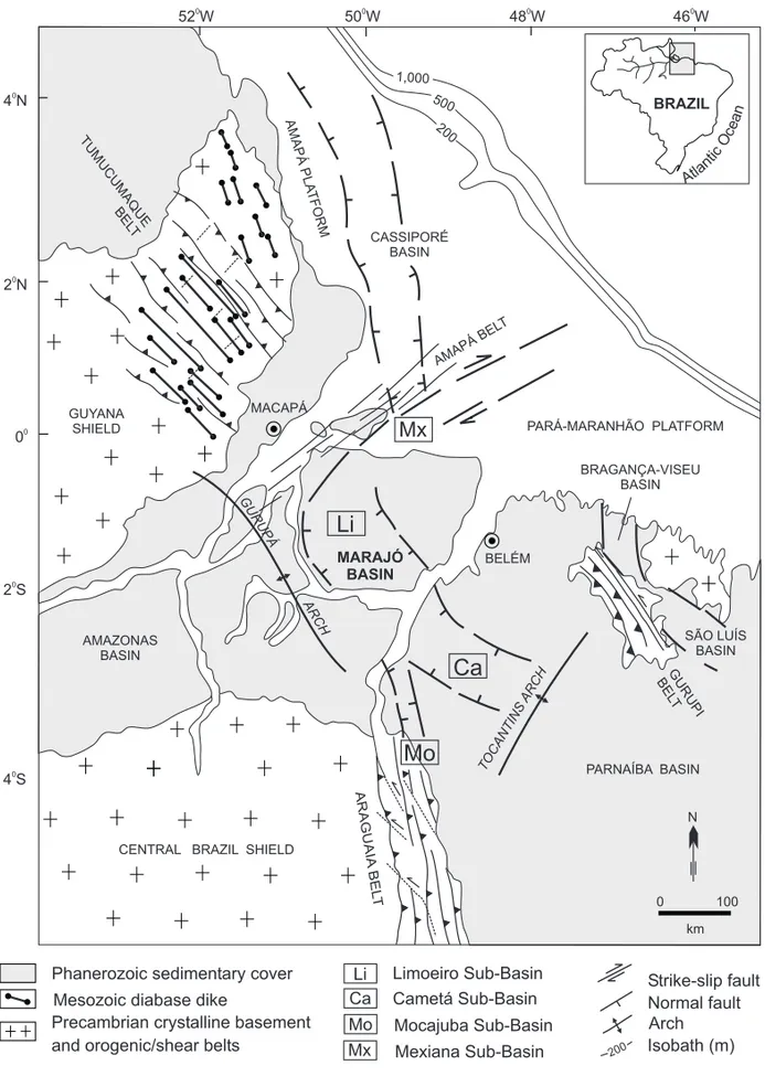
Beneath a thick Tertiary sequence in the Marajó Is-land and adjacent areas there is a large extensional Mesozoic rift system which consists of four major sub-basins (Mexiana to the north, Limoeiro in the center, and Cametá and Mocajuba in the south; Fig-ure 1), evidenced from gravity and magnetic data and detailed seismic interpretation (Rezende and Ferradaes 1971, Schaller et al. 1971, Miller and
Correspondence to: João Batista Sena Costa E-mail: jbsena@iesam.com.br
*Member of Academia Brasileira de Ciências
Avenius 1986, Carvajal et al. 1989).
AMAZONAS BASIN
SÃO LUÍS BASIN
CENTRAL BRAZIL SHIELD
PARNAÍBA BASIN PARÁ-MARANHÃO PLATFORM
BRAGANÇA-VISEU BASIN GUYANA
SHIELD
BELÉM CASSIPORÉ
BASIN
TO CANTINS
ARCH MARAJÓ
BASIN
ARCH
1,000 500
200
52 W0
4 N0
2 N0
00
2 S0
4 S0
50 W0 48 W0 46 W0
0 100
MACAPÁ
Mx
GURUPÁ
Li
Ca
Mo
BRAZIL
Atlan
ticO
cean
Limoeiro Sub-Basin
Mx Mo Ca Li Phanerozoic sedimentary cover
Mexiana Sub-Basin Mocajuba Sub-Basin Cametá Sub-Basin Precambrian crystalline basement
and orogenic/shear belts Mesozoic diabase dike
N
200 Isobath (m)
Arch
Strike-slip fault Normal fault
km AMAPÁ
PLA TFORM TUMUCUMAQUE
BEL T
GURUPI BEL
T
ARAGUAIA
BEL
T
AMAPÁ
BELT
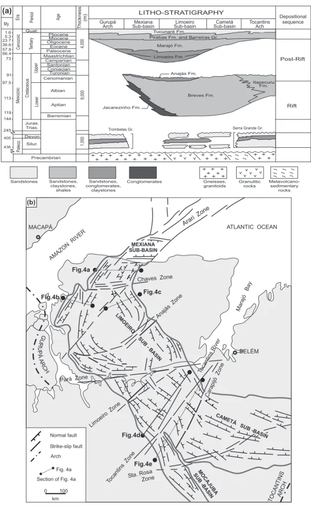
The stratigraphic studies of the Marajó Basin demonstrated that the oldest sedimentary sequence is Paleozoic and is correlated with the Serra Grande Group (Ipú, Tianguá and Jaicós formations) of the Parnaíba Basin, and Trombetas Group (Autás-Mirim, Pitinga and Manacapuru formations) of the Amazonas Basin (Caputo 1984, Lima 1987, Carva-jal et al. 1989) (Figure 2a).
The Marajó Basin filling is composed of a sed-imentary pile from Early Cretaceous to the Oligo-cene, which reaches a thickness of up to 11 km (Lima 1987). It is divided into the Rift and Post-Rift Se-quences (Figure 2a).
The Rift Sequence is formed by two sedimen-tary units (Miller and Avenius 1986, Carnes et al. 1989, Carvajal et al. 1989). The oldest rift unit could be linked to the early rifting and is only rec-ognized by seismic-stratigraphic studies; it appears to be concordant to the upper one (Carvajal et al. 1989) and it may be Neocomian in age (Carnes et al. 1989). The youngest unit is related to the widen-ing of the basin, and was defined by seismic inter-pretation and well data samples; it seems to be more homogeneous and is characterized by discontinuous seismic reflectors, and the borehole data indicate de-position in continental to transitional environments, mainly by fluvial and fluvial-deltaic systems (Breves Formation, Itapecuru Formation in the southeastern edge of the Cametá Sub-Basin).
The Rift column includes fanglomerates and coarse sandstones of talus and alluvial fan deposits (Jacarezinho Formation) deposited on the west side of the Mexiana and Limoeiro sub-basins, and along the Cametá Sub-Basin. Avenius (1988) mentions the occurrence of mud-rich silt beds overlying the Breves Formation, probably deposited in large shal-low lakes or, alternatively, during a transgression restricted to the Mexiana and Limoeiro sub-basins (Anajás Formation).
The seismic signature of the Post - Rift Sequence is characterized by continuous reflectors formed by alternating layers of clay and silt, ev-idenced by borehole data from the Mexiana and Limoeiro sub-basins (Lima 1987). This sequence
includes two major units (Schaller et al. 1971): the lower one (Limoeiro Formation), Paleocene, is made up of sandstones and subordinate conglomer-ates and clays; and the upper unit is formed by two packages, deposited conformably over the Limoeiro Formation and derived from deltaic and fluvial en-vironments from Eocene-Pliocene (Marajó Forma-tion) and Quaternary (Tucunaré FormaForma-tion).
The upper part of the Marajó Formation is cor-related to the Pirabas Formation, a shallow water marine sequence, and Barreiras Group, a transitional one, and have been interpreted as linked to the neo-tectonics, as well as the Quaternary deposits (Tucu-naré Formation; Costa et al. 1996).
Neotectonics comprises two sets of structural and morphological features: (1) the Miocene-Pliocene oldest set includes NW-trending transten-sional basins, which resulted from displacement along E-W and NE-SW dextral strike-slip faults; (2) the Pleistocene-Holocene youngest set corresponds also to transtensional structures. In the Miocene the shallow sea (‘‘Pirabas sea’’) gradually expanded on the continent and reached 150 km in the north-eastern of the Pará State, followed by gradual con-traction that allowed the development of the major rivers. These rivers run chiefly parallel to the NE-SW strike-slip faults that originated from the reacti-vation of Mesozoic strike-slip faults throughout the Quaternary.
This study, based on prospecting seismic data and geological mapping, is meant to discuss rift ar-chitecture, basement control on basin development and landscape evolution related to the opening of the Equatorial Atlantic.
STRUCTURE OF THE MARAJÓ BASIN
The disposition of Rift depocenters and depocen-ter controlling faults suggest a half-graben struc-tural/stratigraphic architecture of the Marajó Basin with the sub-basins being separated and segmented by ENE and NE-SW strike-slip faults (Carnes et al. 1989, Lara 1992, Villegas 1994).
Sandstones Sandstones, claystones, shales Sandstones, conglomerates, claystones Conglomerates Gneisses, granitoids Granulitic rocks Metavolcano-sedimentary rocks MACAPÁ AMAZON RIVER ATLANTIC OCEAN MEXIANA SUB-BASIN Arari Zone Chaves Zone Fig.4a Anajás Zone Fig.4c LIMOEIRO SUB - BASIN Fig.4b Tocantins River Limoeiro Zone Fig.4d MOCAJUBA SUB -BASIN Tocantins Zone
Sta. RosaZone
Fig.4e BELÉM CAMETÁ SUB -BASIN Marajó Bay Carapijó Zone Normal fault
Section of Fig. 4a Arch Strike-slip fault Fig. 4a TO CANTINSARCH G U R U P Á AR CH 0 100 km Pará Zone (b) Limoeiro Fm. Marajó Fm. Tucunaré Fm.
Pirabas Fm. and Barreiras Gr.
Anajás Fm.
Jacarezinho Fm.
Breves Fm.
Itapecuru Fm. My. Era Period Age
Quat. Cenozoic Tertiary Upper Lower Mesozoic Cret aceous Pliocene Miocene Oligocene Eocene Paleocene Maastrichtian Campanian Santonian Coniacian Turonian Cenomanian Albian 1.6 5.3 23.7 36.6 57.8 66.4 73 91 97.5 113 119 144 245 405 436 4,000 8,000 1,000 Aptian Barremian Juras. Trias. Devon. Silur. Paleoz. Precambrian Thickness (m)
(a) LITHO-STRATIGRAPHY Depositional
sequence Tocantins Ach Cametá Sub-basin Limoeiro Sub-basin Mexiana Sub-basin Gurupá Arch Post-Rift Rift
Trombetas Gr. Serra Grande Gr.
and northern boundaries, respectively with Mexiana and Cametá sub-basins, are defined by the Arari and Tocantins strike-slip fault zones (Figure 2b). At the northern end of the Limoeiro Sub-Basin the major normal faults curve northeastward to join the Arari Zone. This sub-basin is divided by minor strike-slip fault zones (Chaves, Anajás, Pará and Limoeiro zones) into five distinct geometric extensional com-partments, but their western margins are dominated by large listric normal faults. Some listric main bor-der faults have up to 6 km basement normal throw (Miller and Avenius 1986, Villegas 1994).
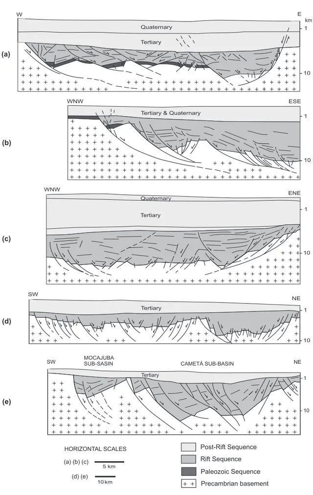
The northwestern portion of the Limoeiro Sub-Basin have major normal faults which curve north-eastward to join the Arari Zone. This sub-basin is formed on the west boundary by a series of linked listric normal faults gently dipping to the south-east and reaching a horizontal position at shallower depths in the basement (Figure 3a). A roll-over is well-developed in the hanging-wall of the detach-ment fault, defined by rotated blocks of the base-ment and lower Rift Sequence into the boundary. This large anticline has been partly modified by pla-nar and listric minor faults dipping towards the east. The eastern flank is defined by planar and listric nor-mal faults dipping about 60oto the west with a roll-over on the flat-lying segment of the major fault, at depth, which dies out gradually upwards on the steep planar segment, where dominate an open syncline; these features are associated with a large negative flower structure which affects also the Tertiary pile and is interpreted as the result of dextral strike-slip displacement along the Arari Zone.
The central part of the Limoeiro Sub-Basin is characterized on the west by an imbricated fan of listric normal faults dipping to the east-northeast, that probably become horizontal at a depth of about 15 km, where they should sole into the detachment zone (Figure 3b). Eastwards, there is another listric fan with a series of minor normal faults connect-ing to the detachment at shallow depths in the base-ment, which seems to control the development of the youngest Rift Sequence (Figure 2a).This imply that the Limoeiro Sub-Basin underwent high rate of
extensional collapse during later rifting, which ex-plains also its greater width (Carnes et al. 1989). A series of listric faults also define the east boundary of this sub-basin, but there are normal faults cut-ting the entire Rift pile suggescut-ting several pulses of faulting (Figure 3c). There are often high blocks of the basement in the center separating the earlier Rift depocentres near the sub-basin flanks (Figure 3d). This geometry can be followed southeastwards until the Tocantins Zone.
A large isolated NNW-trending basement horst block separates the Cametá from the Mocajuba Sub-Basin (Figure 2b). The Cametá Sub-Sub-Basin displays an asymmetric geometry formed by three smaller de-pocenters bounded on the west flanks by planar and listric normal faults dipping to the NNE. The roll-over is followed on both the basement and filling, but a synform dominates upwards on the steep seg-ments of the major faults. The eastern margin of the sub-basin is dominated by a broad flexural response to the border fault system of the west since the base-ment and lower Rift Sequence dip away from the boundary (Figure 3e). The geometry throughout the Mocajuba is similar to that of the Cametá Sub-Basin, but it has been suggested that the basement horst block may have been an effective barrier against intrabasinal communication allowing a package of sediments unique to the rest of the basin to be de-posited (Carvajal et al. 1989).
struc-E
1
10 Quaternary
Tertiary W
Tertiary & Quaternary
ESE WNW
10 1
WNW
Quaternary
Tertiary
ENE
1
10
SW
Tertiary
NE
1
10
Post-Rift Sequence Rift Sequence Paleozoic Sequence Precambrian basement
(a)
(b)
(c)
(d)
5 km
10 km HORIZONTAL SCALES
SW MOCAJUBASUB-SASIN CAMETÁ SUB-BASIN NE
Tertiary
1
10 (e)
km
(a) (b) (c)
(d) (e)
tures, which always cut the Cretaceous pile and can be followed in the basement as steep, discrete zones. The NE-SW Arari Zone is the most important and extends from the Gurupá Arch towards the off-shore. Seismic interpretations indicated that this zone is defined by right-stepping en echélonpairs of overlapping pull-apart sub-basins, of which the Mexiana Sub-Basin is the best known feature, with steep larger border faults on both the east and west margins. The thick Tertiary and Quaternary sedi-mentary piles deposited in the Mexiana Sub-Basin implies that the Arari Zone remained active through-out the Cenozoic. The available data suggest a multi-phase tectonic evolution for the Mexiana Sub-Basin which includes the following steps: (1) transtension during the Cretaceous controlling the deposition of a sedimentary sequence more than 5 km in thick; (2) transpression probably in the Late Cretaceous induc-ing chiefly foldinduc-ing; and (3) transtension throughout the Cenozoic originating the Tertiary and Quater-nary piles.
The neotectonic setting is defined by a series of linked E-W and NE-SW dextral strike-slip faults and NW-SE normal faults that are grouped into two sets. The oldest set corresponds to NW-SE nor-mal faults that controlled the deposition of the shal-low water marine sequence (Pirabas Formation) and transitional sequence (Barreiras Group) in the Up-per Tertiary. The youngest set refers to a linked sys-tem of strike-slip faults and normal faults forming Pleistocene-Holocene pull-apart basins of variable. Large slightly rotated blocks, which originated by Upper Pleistocene NW-SE normal faults, domi-nate in the current landscape of the Marajó Island. The sea-cliffs and paleochannels widespread in the eastern side of the island are closely related to the up-lifted blocks, contrasting with large floodplain and dense rectangular drainage pattern of the western side which were developed on subsided blocks. The Marajó Island formed due to the reactivation of the Arari and Tocantins zones which, respectively, cap-tured the lower courses of the Amazonas and To-cantins rivers to the northeast throughout the Qua-ternary.
GEOPHYSICAL SIGNATURE OF THE MARAJÓ BASIN AND THE SURROUNDING BASEMENT
The old tectonic setting of the area around Marajó Basin (Figure 1) is characterized by theAraguaia and Tumucumaque orogenic or shear belts which have been interpreted as the result of Precambrian conti-nental collisions (Hasui et al. 1993, Costa and Hasui 1997). The continuity of the Araguaia and Tumu-cumaque belts, respectively, to north-northwest and southeast, coincides with the area where the Marajó Basin was developed.
The Araguaia Belt trends N-S to NNW-SSE and is composed of meta-sedimentary, mafic and ultra-mafic rocks (Baixo Araguaia Super-Group), migma-tized gneisses and granitoids (Colméia Complex), and high-grade gneisses (Porto Nacional Complex) in the southeastern margin (Hasui and Costa 1990, Hasui et al. 1993). The Tumucumaque Belt, with a NW-SE trend, is exposed from near Macapá to Para-maribo (Suriname) and comprises various rock as-semblages: granulitic rocks (mafic granulites, kin-zigites, enderbitic and charnockitic gneisses) of the Ananaí and Tartarugal Grande suites; medium-grade tonalitic to trondhjemitic gneisses and granitoids of the Guianense Complex; supracrustal rocks (meta-volcanics, iron formations, quartzites, micaschists and metagraywakes) of the Vila Nova Group (João et al. 1979, Lima et al. 1974).
The structural framework of these belts consists of imbricated ductile thrusts systems that are char-acterized by a pervasive mylonitic foliation dipping to the east and northeast. Along the Araguaia Belt there are also NW to NNW-trending strike-slip shear zones that have been interpreted as lateral ramps that accommodated large amount of compression (Hasui and Costa 1990).
Another belt (Amapá Belt), adjacent and paral-lel to the Arari Zone, was suggested by potential field data interpretation, but it has not been studied be-cause it is completely covered by Tertiary and Qua-ternary sedimentary deposits (Hasui et al. 1984).
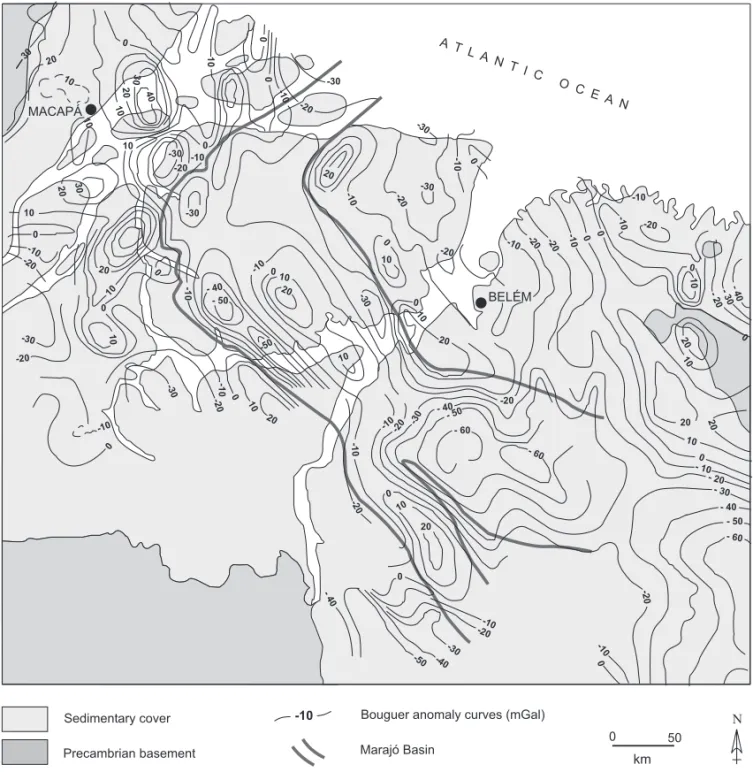
and they are not always coincident with the highs and depocentres of the sub-basins. Several magnetic anomalies also exist: the bipolar anomalies are not related to magnetic geological bodies in the basin filling as these are absent, and the linear anomalies are only partly linked to the major fault zones.
As referred above, the Tumucumaque and Ara-guaia belts are formed by large variety of litho-stratigraphic units, which correspond to high and low density/more and less magnetic rocks, besides strike-slip ductile shear zones. This implies that these rock assemblages should display positive and negative gravity anomaly signatures, as well as bipo-lar and linear magnetic anomalies. Therefore, the geophysical patterns are thought to be mostly due to the rock units and structures of the Precambrian shear belts.
It has been also deduced that the distinct ge-ometric compartments of the Mexiana, Limoeiro, Cametá and Mocajuba sub-basins are closely related to the complex patterns of the ductile thrust systems and strike-slip shear zones of these belts. This is supported by the detachment normal faults dipping to the east and northeast and following the ductile thrust systems, and by the NE-trending anomalies along the Arari Zone coinciding with the strike-slip faulting propagation during the Mesozoic, proba-bly starting with reactivation of shear zones of the Amapá Belt.
In summary, the Precambrian tectonic setting suggests a strong control of the Araguaia and Tumu-cumaque belts in the geometry of the major faults of the Marajó Basin. However, if the Amapá Belt is confirmed, this feature and the Araguaia Belt are to be regarded as the pre-existing crustal weakness zones for the Mesozoic extensional propagation into the northern Brazil.
PALEOGEOGRAPHY
During the Paleozoic the Marajó region and sur-rounding areas interconnected the Amazonas and Parnaíba basins as demonstrated by the remnants of Paleozoic sequences preserved in faulted blocks on the shoulders of the Marajó Rift (Gurupá Arch;
Lima 1987). However, probably by the end of the Paleozoic or Early Mesozoic, the Gurupá high had developed into a well defined horst block with steep normal faults delineating its flanks. The faults of the east flank of the Gurupá Horst form the western margin of the Marajó Rift.
The Marajó Rift may have begun forming in the Early Mesozoic as a result of the separation of the South American, North American and African plates. The early phase of rifting is thought to be of Late Triassic in age with the incipient rifting of the North Atlantic propagated into the South Amer-ican Plate. This is supported by the plate restoration which shows that the Marajó region is on trend with the early rifting stage of the North Atlantic (Miller and Avenius 1986, Carvajal et al. 1989). A Late Triassic-Early Jurassic age for the initial develop-ment of the Marajó Rift coincides also with the mag-matic event represented by dyke intrusions (Cassi-poré Diabase, 250 to 180 Ma; Lima et al. 1974) in Paleozoic sequences and Precambrian basement, but the ages of the propagation of the earliest exten-sional half-grabens are uncertain, mainly because the early Rift Sequence has not yet been sampled.
Several major seismic packages have been demonstrated throughout the basin. The early Rift Sequence is restricted to the both flanks of the Li-moeiro Sub-Basin and the west flanks of Mexiana and Cametá sub-basins, and shows the tendency to thicken into rift faults suggesting distribution in re-sponse to active rifting (Carvajal et al. 1989). This interval and the late Rift Sequence are believed to be composed chiefly of fanglomerates derived from the Gurupá Horst partly during the Albian as suggested by continental clastic interval in the upper portion (Figure 5a).
At-MACAPÁ N 0 50 km Sedimentary cover Precambrian basement
-10 Bouguer anomaly curves (mGal) A T
L A N T I C
O CE A N BELÉM -30 -20 -10 0 0 10 20 30 40 10 0 10 10 30 20 -20 10 0 -10 20 30 -30 -20 -30 -20 10 -10 0 -30 20 -10 0 -30 -20 10 -10 20 0 10 10 0 0 - 40 - 50 -50 -10 20
-10 010
10 20 -30 -30 -20 -10 0 -20 -10 10 0
- 20- 30-40 0 10 -10 -10 0 -20 -10 -30 20 10 -20 -30 - 40
-50 -40 0 -10 -20 0 -10 - 30 - 40 - 50 - 60 0 20 20 0 10 -20 -10 -10 -20 -30 - 40 - 50 - 60 -20
- 60 10
- 10 - 20 20
10
20 0
-10 0 -20
-20
0
Marajó Basin
Fig. 4 – Simplified Bouguer anomaly map of the Marajó rift and surrounding areas.
lantic rifting (Figure 5b). Additionally, it must be considered the existence of the drainage divide be-tween Marajó Rift and the young Atlantic Ocean, which has worked as a natural barrier for the de-velopment of a large drainage area in the north and east of Marajó region. It must be conceded that the Mexiana Sub-Basin is ideally situated to have re-ceived a marine incursion during the latest rift time since the Arari Zone would have been a shorter route
to the early North Atlantic and the Marajó region. However, it is proposed here that much of the rift fluvial clastics of the Mexiana Sub-Basin derived from the broad surrounding platforms (Amapá and Pará-Maranhão).
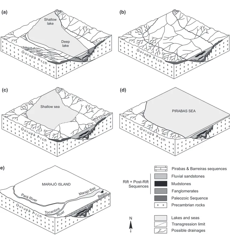
PIRABAS SEA
MARAJÓ ISLAND
Pará
River Belém
Deep lake Shallow
lake
G u ru pá A r ch
G u ru pá A r ch
G u r u pá
A r ch G u r
u pá A r ch
G u ru pá A r ch
Tocantins
River
Marajó B ay
Precambrian rocks Paleozoic Sequence Fanglomerates Mudstones Fluvial sandstones
Pirabas & Barreiras sequences
Lakes and seas Transgression limit Possible drainages N
(a) (b)
(c) (d)
(e)
Shallow sea
Rift + Post-Rift Sequences
Fig. 5 – Four stages of the paleogeographic evolution of the Marajó region and surrounding areas. (a) Early-late Rift stage with the asymmetric depocenters being filled by fanglomerates derived greatly from the Gurupá Arch. (b) Later Rift stage characterized by a major fluvial system flowing into the Marajó Basin from west and southwest. (c) Post-rift stage defined by a more symmetric graben configuration with marine influence to the north. (d) Miocene-Pliocene physiography with the ”Pirabas sea” incursion reaching 150 km in the continent. (e) Quaternary physiography largely characterized by fluvial-estuarine morphology.
unconformity that separates the Post-Rift Sequence from the Rift Sequence. The Post-Rift Sequence de-posited from Maastrichtian times to the Early Oligocene, probably over an area of little physio-graphic variation since it is characterized by a fairly continuos package composed of fluvial and deltaic clastics which thickens to the north, where a marine
The sediments supplied by the Tocantins River have been covered the southern Limoeiro, Mocajuba and Cametá sub-basins.
The Eocene marks another marine incursion in the Marajó Basin that reaches the northwestern Cametá Sub-Basin. In this sub-basin the transitional environment is evidenced from flaser structures and widespread bioturbed sediments, as well as black shales with high organic content derived probably from mangroves (Schaller et al. 1971). During the Eocene-Oligocene the major hydrographic basins of the Amazon region (Solimões, Madeira, Negro, Amazonas etc.) has flowed eastward due to the An-dean uplifting. This suggests that the sediment load-ing of the Amazon drainage system has greatly af-fected the northwestern portion of the Marajó Basin since the Late Eocene.
In the Miocene-Pliocene much of the Marajó region and surrounded areas subsided in response to transtension linked to the dextral strike-slip regime of the neotectonic scenario. This led to marine in-cursion over large areas in the northern Brazil which is demonstrated by shallow water marine sequence (Pirabas Formation) followed by transitional se-quence (Barreiras Group) exposed along the coast and underlain the Pleistocene deposits up to 150 km in the continent (Figure 5d).
The current landscape of the Marajó region and surrounded areas is characterized by fluvial deposits of the Amazon and Tocantins rivers greatly influ-enced by marine incursions. This fluvial-stuarine morphology is the result of the Tocantins River cap-tured to the northeast and Marajó Island formation in the Late Pleistocene (Bemerguy 1997; Figure 5e).
CONCLUSIONS
The overall arcuate shape of the Marajó Rift and complex faulting geometry of the sub-basins are believed to be controlled by the combined weak zones of three distinct Precambrian orogenic belts. General trends and fault patterns of the Mocajuba, Cametá and Limoeiro sub-basins are strongly influ-enced by ductile thrusts and strike-slip shear zones within the Araguaia and Tumucumaque belts, while
the trend and fault systems of the Mexiana Sub-Basin run parallel to the weakness zones of the Ama-pá Belt.
Regional tectonic and stratigraphic evidence suggests that the Marajó Rift has a half-graben ar-chitecture that developed as a result of Mesozoic extension and shearing. Several strike-slip faults segmented the basin into geometric distinct exten-sional compartments and controlled the stratigraphy along its axis. Some faults are always characterized by smaller pull-apart sub-basins along striking with the Mexiana Sub-Basin being attributed to the en echélon pattern within the Arari Zone. Therefore, Mocajuba, Cametá and Limoeiro sub-basins are pri-marily extensional while the Mexiana Sub-Basin is greatly transtensional.
The Rift Sequence developed in response to active rifting and was filled by continental clastic sediments derived chiefly from the Gurupá Arch. In contrast, the Post-Rift Sequence deposited during a large quiescence period and received fluvial and deltaic clastics with marine influence in the north-western of the basin, throughout the Late Creta-ceous-Early Oligocene.
Much of the current landscape is due to trans-tension linked to strike-slip faults, which derived chiefly from the Mesozoic strike-slip faults reacti-vation since Miocene.
ACKNOWLEDGMENTS
We are grateful to PETROBRAS that kindly pro-vided the seismic lines, the Bouguer anomaly data and unpublished reports for this study and the Mas-ter Thesis of J.M. Cahuana Villegas supervised by J.B.S. Costa.
RESUMO
A área da Bacia do Marajó apresenta feições
geológi-cas e geomorfológigeológi-cas devidas principamente à distensão
Mesozóica e à neotectônica pós-miocênica. O evento de distensão, com fases do Cretáceo Inferior e Superior,
ori-ginou quatro sub-bacias que contituem a Bacia do Marajó,
com uma espessa seqüência clástica continental
e direcionais NE e ENE controlaram a geometria da
ba-cia. A distensão, relacionada com a abertura do
Atlân-tico Equatorial, propagou-se continente adentro ao longo
de zonas de fraqueza crustal dos cinturões orogênicos
pré-cambrianos Tumucumaque, Amapá e Araguaia. O
evento neotectônico é um regime transcorrente que
de-senvolveu bacias transtensivas preenchidas por sedimen-tos marinhos rasos (Formação Pirabas) e seqüências
tran-sicionais (Grupo Barreiras) do Terciário Superior,
segui-dos por depósitos fluviais e seqüências transicionais do
Quaternário, derivadas dos rios Amazoans e Tocantins e
do estuário do Marajó. A paisagem atual tem morfologia
tipicamente estuarina. A morfologia costeira apresenta
escarpas em seqüências transicionais do Terciário Supe-rior, enquanto no interior dominam elevações sustentadas
por crosta laterítica do Pleistoceno Médio, aparadas por
superfície erosiva a 70 m. No leste da Ilha do Marajó
são reconhecidas várias gerações de paleocanais com
se-qüências estuarinas associadas, enquanto no lado oeste
predomina uma planície flúvio-marinha.
Palavras-chave: Bacia do Marajó, estrutura, evolução, paleogeografia, geomorfologia.
REFERENCES
Aguiar GA, Bahia RR and Rezende WM. 1966.
Prospecções geológicas e geofísicas executadas pela Petrobras na Foz do Amazonas. Belém: Petrobras, Departamento de Exploração do Norte. Relatório Interno 584A, 15 p.
Avenius CG. 1988. Cronostratigraphic study of the
post-rift/sin-rift unconformity, Marajó Rift system. Belém: Texaco/Canada Report, 6 p.
Bemerguy RL.1997. Morfotectônica e evolução
pa-leogeográfica da região da calha do Rio Amazonas. Belém: Universidade Federal do Pará. Tese de Dou-toramento, 200 p.
Bemerguy RL and Costa JBS.1991. Considerações
sobre o sistema de drenagem da Amazônia e sua re-lação com o arcabouço tectono-estrutural. Belém: Boletim do Museu Paraense Emílio Goeldi. Série Ciências da Terra (3): 75-97.
Caputo MV.1984. Stratigraphy, tectonics,
paleocli-matology and paleogeography of northern basins of Brazil. Santa Barbara: University of California. PhD
Thesis, 583 p.
Carnes JB, Chou GT, Katz BJ, Lorenzetti E and
Shih TC.1989.Exploration analysis of syn-rift
sec-tion of Marajó Basin. Belém: Texaco/Canada. Re-port 89/109, 61 p.
Carvajal DA, Dorman JT, Kenck AR, Key CF, Miller
CJ and Specht TD.1989. Final report of the third
exploration phase, Marajó. Belém: Texaco/Canada. Report, 61 p.
Costa JBS and Hasui Y.1997. Evolução geológica da
Amazônia. In:Costa ML and Angélica RS(Eds.), Contribuição à Geologia daAmazônia. Belém: SBG/ FINEP, p. 15-90.
Costa JBS, Bemerguy RL, Hasui Y, Borges MS,
Fer-reira Junior CRP, Bezerra PEL, Costa ML and
Fernandes JMG. 1996. Neotectônica da região
amazônica: aspectos tectônicos, geomorfológicos e deposicionais. Belo Horizonte: UFMG. Geonomos 4: 23-44.
Hasui Y and Costa JBS.1990. O cinturão Araguaia:
um novo enfoque estrutural-estratigráfico. In: Con-gresso Brasileiro de Geologia, 36, 1990, Natal.
Anais... Natal, SBG, 6: 2535-2543.
Hasui Y, Haralyi NLE and Costa JBS.1993.
Mega-estruturação pré-cambriana do território brasileiro baseada em dados geofísicos e geológicos. São Pau-lo: UNESP. Geociências 12: 7-32.
Hasui Y, Haralyi NLE and Schobbenhaus C.1984.
Elementos geofísicos e geológicos da região ama-zônica: subsídios para o modelo geotectônico. In: Symposium Amazonico, 2, 1984, Manaus. Anais...
Brasília: DNPM, p. 129-147.
João XSJ, Carvalho JM, Vale AG, Frizzo SJ and
Martins RC.1979. Projeto Sudoeste do Amapá.
Belém: DNPM/CPRM. Relatório Final, 125 p.
Lana M and Milani EJ.1987. Notas sobre a evolução
estrutural da Bacia de Marajó. Belém: Petrobras/ Departamento de Exploração do Norte/Divisão de In-terpretação. Relatório Interno, 18 p.
Lara ME.1992. The architecture of a failed rift
sys-tem: Marajó Basin, northern Brazil. Eos Trans Am Geophys Un (73): 563.
Lima HP.1987. Notas sobre a análise estratigráfica da
Lima MIC, Montalvão RMG, Issler RS, Oliveira
A, Basei MAS, Araújo JFV and Silva GG.1974.
Geologia. In: Projeto RADAM, Levantamento de Recursos Naturais, Folhas NA/NB.22 (Macapá). Rio de Janeiro: DNPM, p. 3-120.
Ludwig G.1964. Geology of the Marajó Basin. Rio
de Janeiro: Petrobras/Departamento de Exploração/ Divisão de Exploração. Relatório Interno, 20 p.
Miller CJ and Avenius CG.1986. Interpretation:
re-gional vibroseis and dynamite seismic survey, Marajó. Belém: Texaco/Canada. Report, 96 p.
Rezende WN and Ferradaes JO.1971. Integração
geológica regional da bacia sedimentar da Foz do Amazonas. Belém: Petrobras/Departamento de Ex-ploração. Relatório Interno, 27 p.
Schaller H, Vasconcelos DN and Castro JC.1971.
Estratigrafia preliminar da bacia sedimentar da Foz do Amazonas. In:Congresso Brasileiro de Geo-logia, 25, 1971, São Paulo. Anais... São Paulo:
SBG, p. 3: 189-202.
Villegas JM.1994. Geologia estrutural da Bacia de