S E Biotechnol. Agron. Soc. Environ. 2014 18(4), 544-557 Focus on:
A review of soils and crops in the Bukidnon Highlands of
Northern Mindanao, the Philippines
Guadalupe M. Dejarme-Calalang
(1), Gilles Colinet
(2)(1) Xavier University College of Agriculture. Department of Agricultural Engineering. Corrales Avenue, 9000. Cagayan de
Oro City (Philippines). E-mail: [email protected]
(2) Université de Liège - Gembloux Agro-Bio Tech. Département Science et Technologie de l’Environnement. Systèmes
Sol-Eau. Passage des Déportés, 2. B-5030 Gembloux (Belgique). Received on February 25, 2014; accepted on November 3, 2014.
Introduction. This article reviews soil and crop production information from Bukidnon, Northern Mindanao, the Philippines. It focuses on the parent materials involved in forming Bukidnon soils, clay forming minerals, soil classiication, types and location distribution, physico-chemical characteristics, soil potentialities and constraints, and the yields of the major crops. Literature. The information discussed was gathered from on-line journals, a compilation of agricultural research reports published in Northern Mindanao, published theses, government data and reports, and books. Bukidnon has existing soil information that could be useful for assessing and monitoring soil fertility and in establishing a regional Land Information System (LandIS). Soils in the Province are classiied according to Soil Order, Great Group and soil type under the USDA Soil Taxonomic Classiication. Data on crop production yields are also available. Soil information is intended more for crop fertilization planning at the broader scale. Studies on geomorphopedology and the interactions of elements within the soil are scarce. The relationship between soil formation and its characteristics and plant responses is not discussed here.
Conclusion. The recommendations arising from this study are: (1) to conduct in-depth geomorphopedological studies in marginal areas of undifferentiated soils, (2) to study the relationship between soil characteristics and crop responses including nutrient assimilation by plants, focusing on phosphorus (P), and (3) to develop a generic protocol and establish a LandIS for mountain areas that can be replicated in other areas in Mindanao, the Philippines.
Keywords. Soil morphology, soil classiication, soil chemicophysical properties, mineralogy, crops, land information systems, Philippines.
Sols et plantes cultivées dans les hautes terres du Bukidnon à Mindanao nord, Philippines (synthèse bibliographique). Introduction. Cet article constitue une revue sur l’information existante quant à la géomorphopédologie et la production des cultures du Bukidnon, Mindanao septentrional, Philippines. Celle-ci traite spéciiquement des matériaux parentaux impliqués dans la formation des sols du Bukidnon, des minéraux argileux, de classiication, type et distribution de sols, des caractéristiques physiques et chimiques, des potentialités et contraintes de sol et des rendements des principales cultures conduites.
Littérature. Cette information a été rassemblée à partir de journaux en ligne, de la compilation de rapports de recherche en Mindanao septentrional, de manuscrits de thèses publiées, de données gouvernementales et de livres. Bukidnon dispose d’information sur le sol qui peut être utile pour évaluer et assurer le suivi de la fertilité des sols et établir un système régional d’information sur les terres, les terrains (LandIS). Les sols de la province sont classés selon l’ordre, les grands groupes et les types de sol de la classiication taxonomique américaine des sols (USDA Soil Taxonomy). Les données sur les rendements sont disponibles. L’information sur les sols est davantage orientée vers la planiication en fertilisation des sols à large échelle. Les études de géomorphopédologie et sur les interactions entre éléments dans le sol sont rares. Les relations entre la formation des sols et les caractéristiques de la réponse des plantes ne sont pas étudiées.
1. INTRODUCTION
This review focuses on two topics: the importance of agricultural lands in Bukidnon and the data available for use in developing a LandIS for the Province. The information presented was gathered from library on-line journal collections on Andosols, geomorphology, Philippine and Bukidnon geology, the soils and crops of Bukidnon; a compilation of agricultural research reports on highland soils, vegetables and other crops in Bukidnon and Northern Mindanao; published theses on agricultural development history, and the soils and crops of Bukidnon; websites of Philippine government agencies for regional and provincial agriculture, economy and demography; Bukidnon provincial government soil and agricultural reports; and books on earth and soil science topics and on vegetables and crops.
1.1. Signiicance of the review paper
The conversion of primary agricultural lands to other uses and the increasing population in the highlands have prompted the use of marginal lands for food production. Marginal lands are characterized by their remoteness from markets and population centers. They have high transport costs, a lack of resources and poorly deined property rights (Briones, 2011). Marginal lands constitute the frontiers of Philippine agricultural production (Raymundo et al., 1985).
The Philippine archipelago has 7,107 islands with a land area of ~ 30M ha. Its economy has always been deeply entrenched in agriculture and, since the Spanish regime, Filipino farmers have raised food crops for self-suficiency and for export to the international market (Merino, 1952). The country’s population census revealed that in 2010 there were 93.4 million Filipinos living in the country (NSO, 2012a). Rapid changes in the land requirements for food took place over the last century. In 1910, the Philippines was sparsely populated (28 persons.km-2); by 2003 it had become a
densely populated country (273 persons.km-2) (Kastner
et al., 2010). Within the span of 10 years – from 2000 (205 persons.km-2) to 2010 (308 persons.km-2) – the
country’s population density increased by 20.7% (NSO, 2012b).
Bukidnon is the food basket of Northern Mindanao and is the largest contributor to the regional agricultural economy. In its early history of agriculture, the Province had already been identiied as suitable for the large scale production of food for export (Lao, 1992). The Provincial population rose from 30,974 in 1907 (Lao, 1985) to 1.3 million in 2010 (NSO, 2012a). As part of the early government’s move to fast track agriculture and to utilize Bukidnon’s timber resources, migrants had been invited to cultivate the soil, prompting the
original inhabitants to integrate themselves into the mainstream. Those who were unable to adapt went deeper into the forest, where they undertook shifting cultivation (Lao, 1992). Shifting cultivation is practiced in many parts of the Philippines, including Bukidnon, but there is no estimate of its areal extent (Schmidt-Vogt et al., 2009). Agricultural lands in the Province are socially, economically and environmentally important, not only for Bukidnon, but also for nearby provinces and nationally. Upstream locations of signiicant watersheds that feed into the water supply of Cagayan de Oro City and adjacent provinces are located in Bukidnon and activities in the highlands consequently affect lowland environments.
Research on geomorphopedology can yield basic information in creating a working knowledge of the land and soil. Data are essential inputs to the building of a LandIS (a “one-stop-shop” information system for land and soil data) in order to facilitate better decision-making on land use. However, less attention has been given to this kind of study, because such an approach does not yield tangible results that can directly contribute to increased crop production. In order to understand the nature of soil and its dynamics, it is imperative to improve its sustainable use, to anticipate degradation trends, to spot problematic areas and to provide sound bases for land evaluation and land conversion decisions. Input data for land use planning and management can only be useful if these are based on reliable measurements. The relationship between plants and inherent soil fertility provides essential information for developing effective strategies and practices in crop production and management. A LandIS therefore needs to be established in order for stakeholders to easily access information.
1.2. Structure of the review paper
This review discusses the information currently available for use in the development of a LandIS in the Bukidnon highlands and identiies issues of concerns. The sections of the paper are structured as follows: – geography, topography and climate of Bukidnon, relating to its geographical position, ecological zones with respect to elevation, and the climatic conditions of the Province;
– geological background and associated rocks, relating to the geological formation, the Bukidnon geological map and the parent rocks of Bukidnon soils;
by the Province to the Northern Mindanao economy, and the suitability of the crops to the soil environment; – the signiicance of the use of a LandIS in reaching scientiically based and therefore objective decisions in land use planning and issues of concern;
– the conclusion summarizes the main indings of the article. It presents the authors’ opinion on the indings and also makes recommendations for areas of future research to address the issues identiied.
2. LITERATURE REVIEW
This section examines the literature describing the data available for use in creating a LandIS for Bukidnon. It also presents the authors’ view on the existing information and highlights the issues of concern.
2.1. Geography, topography and climate of Bukidnon
Bukidnon is one of the ive provinces of Northern Mindanao, with a total land area of 8,294 km2, extending
geographically from 7°20’-8°40’ to 24°30’-125°30’.
Figure 1 presents a map of Northern Mindanao, showing the Province of Bukidnon. Bukidnon is a landlocked province and is subdivided into three agro-ecological zones (Holmer, 1997), which comprise:
– the mountainous zone of Mt. Kitanglad and Mt. Kalatungan and the Central Cordillera of Eastern
Bukidnon at elevations from 1,200-2,950 m above sea level,
– the high altitude volcanic plains, terraces and footslopes surrounding Mt. Kitanglad and Mt. Kalatungan with elevations ranging from 600- 1,200 m,
– the low altitude volcanic plains, terraces and hills with elevations < 600 m.
The Province is drained by three rivers and their distributaries. From Mt. Kitanglad, the Cagayan and Tagoloan Rivers and their tributaries are the main streams draining the northern part. The eastern section is drained by the Manupali River from Mt. Kalatungan. The Maladugao and Muleta Rivers drain the south-eastern part of the Province and eventually contribute to the discharge into the Pulangi River.
Climate affects the rate of rock weathering and soil formation (Grotzinger et al., 2007). The Philippines has a tropical and maritime climate, which is classiied into four types (PAGASA-DOST, 2014). Type I has two seasons, dry from November to April and wet during the rest of the year. Type II has no dry season, but has a very pronounced maximum rain period from December to February. Type III has no pronounced maximum rain period, but has a dry season lasting between only one and three months. Type IV has rainfall that is more or less evenly distributed throughout the year. Two types of climate prevail in Bukidnon, Type III in the northern part and Type IV in the south. The 30-year
mean annual rainfall has been recorded at Malaybalay Weather Station as 2,569 mm, with the wettest months being from July to October (PAGASA-DOST, 2014). The 1994-1996 annual rainfall data for the Manupali Watershed at 1,500 m asl was 2,825 mm and during that period, only one month had a level of rainfall < 100 mm (Poudel et al., 2000). Temperature and relative humidity vary with elevation. Mean annual temperature and relative humidity have been recorded at < 500 m asl as 27 °C and 74%, respectively (CMU, 2012). Mean annual temperature in areas with elevations > 500 m asl have been recorded as 18-28 °C, with a relative humidity of ~ 80% (Sustainable Watershed Ecosystems Management Resource Center, 2013). The areas around the volcanic slopes exhibit semi-temperate conditions, which can support a broad range of highland tropical crops (Sustainable Watershed Ecosystem Management Resource Center, 2013).
2.2. Geological background and associated rocks
The Philippine archipelago is located within the circum-Paciic seismic belt where plate tectonic movements and lithospheric collisions are very active. The archipelago is wedged between two converging plates: the oceanic northwest-moving Philippine Sea Plate in the east and the Sunda Block/Eurasian Plate in the west, which resulted in the formation of the Philippine Fault (Yu et al., 2013). According to Aurelio et al. (2012), the archipelago is the outcome of a complex series of geological events that involved continental rifting, oceanic spreading, subduction, ophiolite obduction, arc-continent collision, intra-arc basin formation and strike-slip faulting. The archipelago became subdivided into two tectono-stratigraphic blocks, the Palawan-Mindoro Continental Block (PCB) and the Philippine Mobile Belt (PMB).
Cretaceous ophiolites of the PMB strung along the eastern Philippines, which include northern and southern Mindanao and foraminiferal limestone that represents the Paleocene, have been found in the drill cores in the Agusan-Davao Basin (Aurelio et al., 2012). Reef limestone formations, in association with rocks of different ages are found in the high mountains of the Philippines, including along the common border of Bukidnon, Agusan, South Cotabato and Davao Oriental in Mindanao (Raymundo et al., 1985). Young andesitic to dacitic volcanism, mostly represented by ash and lapilli and domes, are emplaced along the Philippine Fault (Sajona et al., 1997). Subduction related volcanism during the Pleistocene deposited volcanic rocks (basalt, andesite and dacite) and related pyroclastic products throughout the Philippines, except for north-east Luzon (Aurelio et al., 2012). Central Mindanao is an example of a young collision of two island arcs, which are devoid of the old continental
basement (Sajona et al., 2000). The Central Mindanao Volcanic Field is characterized by numerous Pliocene-Quaternary basaltic to andesitic strato-volcanoes and minor parasitic dacite cones (Sajona et al., 2000). The whole of Bukidnon is of volcanic origin, except for the southern part, which consists of sedimentary materials and limited alluvial plains along the rivers (Mariano et al., 1955). Figure 2 shows the geological map of Bukidnon. Analyses of rock samples from Mt. Kalatungan have revealed that these are fresh calc-alkaline basalt (Sajona et al., 1997). This means that the rocks are under-saturated melanocrate, with abundant olivine, labradorite, slightly calcic-augite and richer in Na2O and K2O than the tholeitic facies. Rock samples
from Mt. Kitanglad are moderately fresh shoshonitic basalt (with Na2O and K2O) and andesite (Sajona et al.,
1997). In northern Bukidnon, the low grassy hills east of Malaybalay, are mainly metamorphic (schist) rocks with cappings of limestone, which form the low hills in the location (Mariano et al., 1955).
2.3. Bukidnon soils
The irst soil resource inventory in the Philippines was created in Batangas in 1903 by Clarence W. Dorsey and focused on soils for abaca (Raymundo et al., 1985). Much progress was made in the late 1920s, when Dr. Robert Pendleton worked on the sugar lands of Negros Island and simultaneously trained Filipino students (Raymundo et al., 1985). The actual soil inventory in the country began in the provinces in 1934, when the soil survey committee was created, but progress was interrupted by the Second World War (Carating et al., 2014). The soil series is the key pedological unit for soil mapping (Mariano et al., 1955).
that in Mindanao, few studies have been conducted on the physico-chemical and mineralogical properties, genesis and classiication of soils. Several studies on soils derived from volcanic material have revealed the presence of allophanes and imogolites (Poudel et al., 1999; Bertrand et al., 2008; Kimsey et al., 2011; Levard et al., 2012; Mileti et al., 2013). The minerals identiied in the Central Mindanao volcano ield were olivine, pyroxene, plagioclase and other phases, such as titanomagnetite, hemo-ilmenite, amphibole ranging from magnesio-hornblende to tschermakites and apatite, which were observed in western and eastern andesitic and dacitic rock outcrops (Sajona et al., 2000). In a study of the soil in Intavas, Impasug-ong, Bukidnon, which is situated at 1,200 m asl, the primary minerals were found to be predominantly
opaque minerals (Bacatio et al., 2005). Hornblende and heavy minerals and weathered particles composed of mica, quartz and volcanic glass for light minerals were found here, while for clay soils, gibbsite and halloysite were detected (Bacatio et al., 2005). Clay forming minerals identiied in the soil of a volcanic slope within the Manupali Watershed of Bukidnon were halloysite, gibbsite, goethite, hematite and cristobalite and the presence of allophanes and imogolites was also observed in all the studied pedons (Poudel et al., 1999). The presence of both goethite and hematite indicates a state of mineral evolution in an ecological situation.
Soil distribution location. The Soil Survey Report of Bukidnon was published in 1955. Soils are grouped
according to: (1) soil series, (2) soil type, (3) a phase of a soil type, and according to (4) complex, (5) miscellaneous undifferentiated soils from rough broken lands and mountains (Mariano et al., 1955). The USDA Soil Taxonomic Classiication is used in naming Philippine soils. The National Bureau of Soil and Water Management has identiied nine Soil Orders in the country, namely: Inceptisols (39.9%), Ultisols (26.6%), Alisols (17.1%), Entisols (8.1%), Vertisols (4.5%), Mollisols (3.3%), Andisols (0.23%), Oxisols (0.2%) and some limited Histosols (PCARRD, 2006).
Figure 3 shows the soil map of Bukidnon Province. Soil Orders/Great Groups and their distribution in Bukidnon are presented in table 1.
Soil morphology. Volcanic mudlows or lahars from Mt. Kitanglad and Mt. Kalatungan underlie the greater part of the Bukidnon Plateau, and the rest of the Province with other kinds of igneous materials and a few local metamorphic rocks (Mariano et al., 1955). The moderate weathering of mainly pyroclastic materials produces soils with andic properties. However, some soils develop these properties from non-volcanic materials, including loess, argillite and ferralitic weathering products (FAO, 2006). In order for a soil to be deined as having andic properties, it must meet the FAO (2006) diagnostic criteria:
– > 2% Alox + ½ Feox value, – a bulk density of < 0.90 kg.dm-3,
– phosphate retention of > 85%, – organic carbon < 25% by mass,
– it must meet the requirements of an albic horizon if occurring under tephric materials.
Poudel et al. (1999) reported that, according to the USDA Soil Taxonomic Classiication, the soil development gradient in the Manupali Watershed ranged from Inceptisol in the mountains to Ultisol and Oxisol at lower elevations. Moreover, the authors identiied the Soil Great Groups as Humitropept and Hapludult in the mountains, Kandiudox in the upper footslopes, Acrudox and Hapludox in the lower footslopes and Acrudox and Kandiudox in the alluvial terraces. Soil in Intavas, which is representative of cultivated, highland marginal soil, has been classiied as ine clayey, acid, isothermic, gibbsittic, and as Oxic Dystrudepts (Bacatio et al., 2005).
In the Bukidnon soil map, no soil is classiied under the Andisol Soil Order or Andosol Soil Group, although many parent rocks come from volcanic materials. Furthermore, the descriptions of these soils do not present “andic” properties. Mineral weathering can dramatically change soil mineralogy and chemistry (Mileti et al., 2013). Poudel et al. (1999) stated that during the weathering process, Andisols lose some of their unique properties and change into other Soil
Orders, including Inceptisols, Alisols, Entisols, Oxisols, Spodosols, Vertisols, Mollisols and Ultisols. Therefore, because of weathering, soils in Bukidnon may have lost their “andic” characteristics during this process.
Andic properties can be retained if the soil is pro-tected or undisturbed. Tsui et al. (2013) found that of the 60 pedons they studied in YMS National Park in Taiwan, 40 pedons were classiied as Andisols. They also discovered that these Andisols were generally found at elevations > 700 m asl, with gentle or steep slopes, possibly because a thick growth of plants provided protection for soils. Raymundo et al. (1985) stated that “In the Philippines, a good number of soils have been previously classiied as Andepts. Hydric Dystrandepts (inclusion of the Tigaon series) are found on the slopes of Mt. Isarog, the Hystrandepts at around 800 m elevation in Mt. Makiling (unclassiied) area, and possibly Eutrandepts over the slopes of many volcanic peaks. The Tagaytay, Taal and Tupi series in Cotabato may be classiied as Andisols”. Pedological research in Bukidnon has made little progress; thus information on soils with “andic” characteristics is unavailable. In addition, the soils in some areas of the country are unclassiied, such as in Mt. Kitanglad and Mt. Kalatungan, which are volcanic mountains. None of the areas bordering the Agusan and Davao Provinces, the Pantadon Range or Mt. Malambo has been studied and there is therefore no soil information available for these areas.
551
Table 1. Distribution locations of soils in Bukidnon — Occurrence des sols au sein du Bukidnon (1Mariano et al., 1955; 2PCARRD, 2006).
Topographic groups Soil series Parent material1 Soil order/soil great group2 Distribution location1
Alluvial plain soils Maapag series Alluvium Inceptisol Lowland plains in Managok, Minlawan, Simaya, Nabago,
Maapag and Dagatkidavao
San Manuel silt loam Recent alluvium deposit Inceptisol/Dystropepts Small areas along Pulangi River near Valencia and
south-east of Dologon
Mailag clay loam An abandoned river bed Inceptisol Occurs in Mailag and in part of the plain southwest of
Maramag
Soils on a plateau Adtuyon clay Volcanic lava or lahars
composed of mixed boulders (basalt and andesite)
Ultisol/Paleudults,
Hapludults Covers almost extensively the entire Bukidnon Plateau. Total area 205,124 ha, covering 25.52% of the Province
Kidapawan clay loam Similar to Adtuyon clay
(presence of boulders) Ultisol/Hapludults Second most extensive soil. Total area of 139,189 ha or 17.30%. Occurs on the lower slopes of Kitanglad and Kalatungan and in the south and west of Kibawe
Jasaan clay Volcanic materials Ultisol/Hapludults Occurs in Alae and its vicinity in the north central part
adjoining Misamis Oriental
Calauaig clay Metamorphic rocks (schist) (no classiication) Occurs in the low grassy hills east of Malaybalay. Total
area is 4,363 ha or 0.54% of the Province
Faraon clay Limestone Inceptisol/Eutropepts Occurs in the low limestone hills between Kisolon and
Tankulan and in three separate places along Sayre Highway and Kibawe in the southern part. Total area is 10,296 ha or 1.28% of the Province
Bolinao clay Limestone residues Inceptisol/Eutropepts Occurs in the north-western part of Bukidnon and occupies
1,952 ha or 0.25% of the Province
Alimodian clay Sedimentary rocks (shale) Alisol/Hapludalfs Low smooth hills north and north-west of Tankulan and
the hills of Kiliog, covering 15,726 ha or 1.79% of the Province
La Castellana clay Igneous materials (mainly
basalt and andesite) Alisol/Hapludalfs Covers Musuan Volcano and similar hills, west of Maramag Poblacion. Total area of 45,254 ha or 5.63% of the Province
Tacloban clay Shale and associated rocks Alisol/Hapludalfs Occupies the southern part of adjoining Cotabato Province
with a total area of 4,447 ha or 0.55% of the Province
Macolod clay Weathered products of
volcanic materials Inceptisol/Eutropepts Occupies the southern part of the Province on both sides of the Pulangi and Muleta Rivers and covers an area of 52,921 ha, 6.58% of the Province
Miscellaneous land
types Rough broken land Occurs east of Impasugong continuing to a large portion of Malitbog in the northern part of the Province
Mountain soils, undifferentiated Mt. Kitanglad, Mt. Kalatungan and the whole portion bordering Agusan and Davao
Soil chemical properties. Earlier studies on the chemical characteristics of Bukidnon soils were conducted in conjunction with the Soil Survey to identify and classify soil types based on their morphological and genetic characteristics, as they occur in the ield (Marfori et al., 1955). The soil chemical parameters analyzed were: soil reaction (pH), soil organic matter content (SOM), total nitrogen (N), available phosphorus (P), available calcium (Ca), potassium (K), magnesium (Mg), iron (Fe), and manganese (Mn). The report also presented recommendations regarding the addition of lime and fertilizer to soils.
Soil pH is the most indicative measurement of its chemical properties in terms of ecological processes, because of its inluence on nutrient availability. Soil pH values derived from recent studies are shown in
table 2. Busdi and St. Peter are located near the Central Cordillera in Eastern Bukidnon. Sungco and Kibangay are on the slopes of Kitanglad and Kalatungan. The Manupali Watershed is located within Kitanglad at the north-west boundary and Kalatungan in the south-west. The Miarayon Region is on Mt. Kalatungan.
In Bukidnon, SOM content ranges from low to high, depending on location. Soils at higher elevations generally have a higher SOM content (Holmer, 1997). The soil organic carbon (SOC) content of Intavas soil is 4.3%, which irregularly decreases at depth (Bacatio et al., 2005). Thirteen soil surface horizon samples from the Manupali Watershed revealed that the total carbon in mountain pedons ranged from 8.2-13.2%, while at the lower elevations the levels ranged from 2.5-5.3% (Poudel et al., 1999). In their study of soils in the Miarayon region, Tatoy et al. (2001) found that the total SOC values were: in Lirongan, 9.3%, Miarayon, 17.2% and San Miguel 18.3%. Results of SOC analyses from ields in these villages were derived from the examination of four composite samples that were taken from representative locations in each village. Volcanic soils generally have higher SOM content
levels of organic matter compared to non-volcanic soils, which may tend to buffer excessive depletion of SOC (Sandoval et al., 2007). The slow mineralization of SOM in volcanic soils inhibits excessive release of carbon (C) over time and therefore C is conserved in the soil. Bukidnon is relatively cool, especially in the mountainous areas, because of its high elevation. Cool temperatures in the mountainous regions further retards SOM mineralization, which makes its mineral components available only slowly to plants.
Volcanic soils have an extremely high P retention rate, so that 85-90% of inorganic P added to the soil remains unavailable to crops (Mejias et al., 2013). Unavailable forms of P according to PCARRD (2006) are:
– apatite, an original source,
– Ca, Fe and Al phosphates, which are secondary sources,
– organic combinations.
At a low pH (< 5.5) phosphate ions combine with Fe and Al, and at a high pH (> 8.0) with Ca to form compounds that are not readily available to plants (Landon, 1984). Phosphorus deiciency commonly occurs in lateritic red soils in about half of the upland areas of the Philippines (PCARRD, 2006). In his study, Holmer (1997) discovered that only 3% of the total samples analyzed had available P > 25 mg.kg-1. Poudel
et al. (1999) found out that P retention by surface horizons of mountain pedons ranged from 94-98%, while that of other values ranged from 63-81%. For Intavas soils, Bacatio et al. (2005) found that P retention ranged from 58-78%, with the plow layer having the highest values. Tatoy et al. (2001) found that results of soil analyses of composite samples taken from four representative locations in each village in the Miarayon region showed P concentrations of: Lirongan, 1.5, Miarayon, 24.7 and San Miguel, 11.9 mg.kg-1. The challenges
regarding levels of P availability in soil lie irstly, in the regularity of the releases of the nutrient and secondly, in how fast P is replaced in the soil solution and is able to become available for crops before it is sequestered by Fe/Al complexes. High P immobilization forces farmers to use signiicant amounts of phosphate fertilizers in order to obtain suitable yield targets (Mejias et al., 2013). To counteract this limitation, soil amelioration to increase pH to a level suficient to dissociate the nutrient from the Fe/Al complexes needs to be undertaken. It should be noted that in all the references gathered
Table 2. The pH (in H2O) values of some locations in Bukidnon — Valeurs de pH eau pour quelques contextes de sol du Bukidnon.
Location pH H2O Source
Busdi, Malaybalay 6.6-6.9 CAO, 2010
St. Peter, Malaybalay 5.5-6.0 CAO, 2010
Intavas TDF, Impasugong 4.8-5.6, at plow layer 5.0 Bacatio et al., 2005
Sungco, Lantapan 5.5 Holmer, 1997
Kibangay, Lantapan 5.6 Lapoot et al., 2010
Manupali Watershed, Lantapan 4.2-6.3, mean 5.4 Poudel et al., 1999
Miarayon, Talakag 5.1 Tatoy et al., 2001
Lirongan, Talakag 4.9 Tatoy et al., 2001
for the Province regarding soil research, only Poudel et al. (1999) studied the association of aluminum (Al) and Fe in terms of the P ixation capacity of soils in Bukidnon.
Cation Exchange Capacity (CEC) is an overall assessment of soil potentiality, which assesses the soil’s possible response to fertilizers. It is a guide in identifying the kind of clay minerals and the impact of SOM in terms of both quantity and quality (Landon, 1984). Poudel et al. (1999) reported that CEC values in the mountains ranged from 7.5-50.4 cmol.kg-1, in
the upper footslopes, 5.0-21.7 cmol.kg-1 and for the
lower footslopes, 9.0-24.2 cmol.kg-1. Lapoot et al.
(2010) reported a CEC value in Kibangay, Lantapan of 6.34 cmol.kg-1. In their study, Bacatio et al. (2005) found
that Intavas soil had a CEC range of 7.4-17.3 cmol. kg-1, with the highest value being in the topsoil. The
aforementioned values are useful references when evaluating the potential fertility of Bukidnon highland soils.
Soil potentialities and constraints. Based on the information gathered in this review, we can conclude that mountain soils in Bukidnon have potentialities, such as a high SOM with optimal C/N ratios, high CEC values, low bulk density and high water retention, but with rapid drainage during rainfall. Low bulk density results in high porosity, which is essential for the expansion of plant root systems, enabling them to extract more water and nutrients from the soil. A high water retention capacity enables soils to hold more water, which acts as a moisture reserve for plants during periods of drought. Rapid drainage is also favorable for plants sensitive to waterlogging.
The soil constraints in Bukidnon are a too low bulk density, stoniness and rock outcrops, a low pH and possible increasing risks of Al toxicity and high P retention. Low bulk density soils can be associated with a risk of soil erosion. After long periods of drought, the splash effects of heavy rains can easily slake soil aggregates and transport the debris, together with its nutrients, from the surface. Soil erosion predominates in areas presenting steep slopes with sparse vegetation. In recent years, rapid land use changes in the upper Manupali Watershed have caused the heavy siltation of the Manupali River Irrigation System (Lantican et al., 2003). Soils in these areas are shallow and are unsuitable for cultivation and hence are used as pasture lands for cattle.
When pH is low, certain metallic elements present in soil will be mobilized. These can easily be taken up by plants and some of these elements, such as Al, can block root absorption sites. A soil pH of < 5.5 indicates a possible risk of Al toxicity (Landon, 1984). Phosphorus is classiied as a major plant nutrient and most farmers in Bukidnon spend money on P
fertilizers for crop maintenance. Because soil derived from volcanic material retains high amounts of P, its nutrient dynamics need to be studied further in order to ascertain its effective use in farming.
2.4. Major crops in Bukidnon
Bukidnon is the primary producer in Northern Mindanao of maize/corn (Zea mays L.), rice (Oryza
sativa L.), sugarcane (Saccharum oficinarum L.),
pineapple (Ananas comusus [L.] Merr.), banana (Musa
sapientum L.) and high value commercial vegetables:
carrots (Daucus carota L. var. sativus), potato (Solanum
tuberosum L.), cabbage (Brassica oleracea L. var.
capitata) and tomato (Lycopersicon esculentum Mill.
var. esculentum). Pineapple (A. comusus) and banana (M. sapientum) are the two crops grown for export. Rubber (Hevea brasiliensis [HBK] Müll.Arg.) is a major industrial crop.
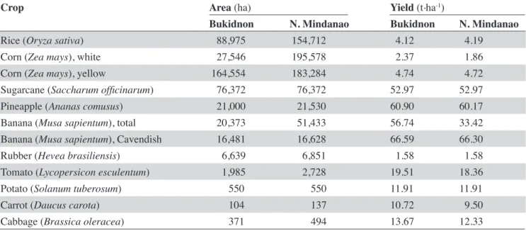
Table 3 shows production data for the major crops of Bukidnon and Northern Mindanao. Rice (O. sativa) is the main staple food in the country. With 88,975 ha of production in the Province, the irrigated areas occupy 78,891 ha, and the rain-fed areas 10,084 ha. The Province’s contribution to the production of rice in Northern Mindanao is 57.5%. The yellow maize
(Z. mays) yield is double that of the yield of the white
variety (Table 3), which makes yellow maize a more attractive crop for farmers to plant. Because yellow maize (Z. mays) has a higher yield than the white variety, there is a disproportionate areal extent of the yellow compared with the white varieties in the Province. The area planted with yellow maize is six times larger than that for white maize (Table 3). The Province produces the only sugarcane (S. oficinarum) in the region. The production of pineapple (A. comusus) and bananas (M. sapientum) is managed by multinational agro-industrial corporations. Much emphasis is placed on the Cavendish banana because it is the only variety grown for export. The regional production of rubber (H. brasiliensis) is largely found in the Province.
Bukidnon is a producer of high value commercial vegetables, which are largely grown on the slopes of Mt. Kitanglad and Mt. Kalatungan in Lantapan and Talakag and in Impasug-ong. Tomato (L. esculentum), carrot (D. carota) and cabbage (B. oleracea) represent 77, 86, and 83%, respectively of the total regional production. Bukidnon is the sole producer of potato
(S. tuberosum) in the region. The production data
show that the Province has higher average yields than Northern Mindanao and there are some crops that are only produced within the Province.
systems, thus making the land suitable for the production of this crop. Generally, soils in Bukidnon possess the aforementioned characteristics required by crops. The higher crop yields in the Province compared to regional values can be attributed to these environmental conditions. However, to date, no study has identiied the links between soil formation and characteristics and crop yields.
2.5. The signiicance of a LandIS
In order to identify the best use of land, it is essential to know what qualities the area has and what impacts on the land and its environment a particular development may bring. The classical land evaluation approach is based on qualitative models, requiring only basic structural knowledge of the speciic landscape and the
Table 4. Soil requirements for major crops in Bukidnon — Exigences pédologiques des principales cultures du Bukidnon.
Crop Soil requirement pH Reference
Rice (Oryza sativa) Heavy soils 5.0-5.6 Landon et al., 1984
Maize/corn (Zea mays) Well drained, no waterlogging 5.0-7.0 Landon et al., 1984 Sugarcane (Saccharum oficinarum) Deep, well aerated but relatively
tolerant to periodic looding 4.5-8.5, optimum 6.5 Landon et al., 1984 Pineapple (Ananas comusus) Sandy loam with a low lime content 4.5-6.5 Landon et al., 1984 Banana (Musa sapientum) Deep well drained loam without
stagnant water 5.0-7.0 Landon et al., 1984
Rubber (Hevea brasiliensis) Deep, well aerated, permeable acid soils Landon et al., 1984 Cabbage (Brassica oleracea) Well drained, optimum 6.0-6.5 Landon et al., 1984 Potato (Solanum tuberosum) Well drained, aerated and porous
soils 4.0-5.6 Landon et al., 1984
Tomato (Lycopersicon esculentum) Light loam, well drained without
water logging 5.0-7.0 Landon et al., 1984
Carrot (Daucus carota) Moist, well drained, loam, sandy
loam 6.0 Rubatzky et al., 1999
Table 3. Major crops of Bukidnon compared to Northern Mindanao, the Philippines — Principales plantes cultivées au Bukidnon et comparaison au sein de la Région Nord de Mindanao (2012).
Crop Area (ha) Yield (t.ha-1)
Bukidnon N. Mindanao Bukidnon N. Mindanao
Rice (Oryza sativa) 88,975 154,712 4.12 4.19
Corn (Zea mays), white 27,546 195,578 2.37 1.86
Corn (Zea mays), yellow 164,554 183,284 4.74 4.72
Sugarcane (Saccharum oficinarum) 76,372 76,372 52.97 52.97
Pineapple (Ananas comusus) 21,000 21,530 60.90 60.17
Banana (Musa sapientum), total 20,373 51,433 56.74 33.42
Banana (Musa sapientum), Cavendish 16,481 16,628 66.59 66.30
Rubber (Hevea brasiliensis) 6,639 6,851 1.58 1.58
Tomato (Lycopersicon esculentum) 1,985 2,728 19.51 18.36
Potato (Solanum tuberosum) 550 550 11.91 11.91
Carrot (Daucus carota) 104 137 10.72 9.50
Cabbage (Brassica oleracea) 371 494 13.67 12.33
object of evaluation and thus must be rearranged if the land use is changed (Manna et al., 2009). But land evaluation has to focus not only on options for food but also on ecological, environmental and social concerns, as these are becoming increasingly important in the planning process (Rossiter, 2008).
A LandIS represents the pooling of information regarding the land, which is a prerequisite when planning for land resource surveys, and which leads to the physical evaluation of the land for its suitability. If there is no information about critical land quality, research must be initiated (FAO, 1989). The Environmental Impact Statement System of the Philippines classiies areas of primary agricultural land as environmentally critical areas, which require an environmental impact assessment whenever development projects are proposed. Soil and land information are inputs in identifying environmental risks that can be associated with the development and how these risks can be managed.
The soil survey of Bukidnon is the earliest comprehensive document that presents provincial soil information (Mariano et al., 1955). This report contains the state of agriculture of the Province, soil survey methods, soils and their morphology, productivity ratings and information regarding physical land evaluation, land use and soil management. It further contains erosion surveys and information regarding the soil chemical characteristics with fertilizer requirements for provincial soils. In that report, and even to date, there are areas that are still unmapped (the mountainous areas). These are the frontiers of agricultural production and are areas that are being increasingly used for farming in the Province. Later sources of information on soil fertility management present useful data and information on Philippine soils and soil fertility management strategies (PCARRD, 2006). However, this reference does not contain the same information for all the provinces in the country. The scale of information needs to be narrowed down to ield level in order for it to be a suitable source of advice for farmers on soil fertility, potentiality, suitability and constraints. As we have seen, soil research has already been conducted and has yielded some useful results. However, the scale of investigation, associated data density and the integration of all types of information needs to be considered in order to provide holistic knowledge about the soil.
3. CONCLUSIONS
The information gathered in this paper presents the background of Bukidnon’s geology and associated rocks, soil morphology, physico-chemical properties, potentiality and constraints and suitable crops.
Naming of soils in the Philippines follows the USDA Soil Taxonomic Classiication and the pedological unit used in mapping is the soil series. Rocks and minerals in Bukidnon soils are associated with volcanic parent materials. However, the soils are not classiied as Andosols/Andisols, nor do they have the “andic” properties qualiier, although results of recent pedological studies in the highlands have corroborated that those soils are remnants of that particular Soil Order/Great Group. Crop yields at the macro-level indicate that Bukidnon has advantages in terms of commercial agriculture compared with other provinces in Northern Mindanao. Few geomorphopedological studies have been carried out on Bukidnon soils. Although the available information relates more to soil fertility status, which is used in fertilization planning, no detailed analysis is available on the dynamics and interactions of nutrient elements within soils. Soils in marginal lands are increasingly being used as crop production areas in the Province. However, these soils are still undifferentiated. Results of previous soil research found that the low level of available P represents a limitation in Bukidnon soils. Although crop yield data suggest that Bukidnon soil is suitable for certain crops, information needs to be gathered at ield level. Based on the indings of our literature review we make the following recommendations: – With increasing utilization of marginal lands and undifferentiated soils, geomorphopedological studies need to be conducted in order to obtain a detailed analysis of soil evolution and the relationship between its physico-chemical characteristics and its environment. A more detailed examination of soil properties is needed in order to identify the enabling and disabling characteristics of the nutrients usable for plants. Such information would provide useful inputs in formulating strategies in managing soil resources when land uses change.
– Although the characteristics of Bukidnon soils show potentialities for crop production, there are cons- traints that need to be addressed. It is recommended to study soil characteristics and plant response in order to identify crop suitability using yields at plot level as indicators. This should also include rates of nutrient assimilation by plants as a way of assessing fertility levels and monitoring soil status. Because of the volcanic origin of Bukidnon soils, P is highlighted as a limiting nutrient. Since P is essential for plant growth, farmers currently have no choice but to invest in this agricultural input as a fertilizer. It is recommended that the dynamics of P nutrients in soils be studied in order to determine the optimal quantity and timing of P fertilization.
established and implemented in land use planning and the management of highland soils. A generic protocol would need to be developed for the LandIS, which could then be replicated in other marginal areas of Mindanao. The cost of developing such an information resource may depend on the level of detail required. In order to avoid the unnecessary use of resources, site representativeness should be an important consideration in choosing investigation sites.
Acknowledgements
The author acknowledges the support of the Cooperation of Universities for Development – Inter University Program, the University of Liege-Gembloux Agro-Bio Tech, Belgium and Xavier University, Philippines for her PhD studies. The author would also like to express her thanks for the assistance of other EPaM project partners: the Catholic University of Louvain and the University of Namur in Belgium, and Environmental Science for Social Change, and Ateneo de Davao University in the Philippines.
Bibliography
Aurelio M.A., Pena R.E. & Taguibao K.J.L., 2012. Sculpting the Philippine archipelago since the Cretaceous through rifting, oceanic spreading, subduction, obduction, collision and strike slip-faulting: contribution to IGMA5000. J. Asian Earth Sci., 72, 102-107.
Bacatio C.D., Kubotera H., Nanzyo M. & Yamada I., 2005. Partial rejuvenation of the soil of Intavas Demo Farm, Bukidnon, Mindanao, Philippines by volcanic ash materials. Special Review. JIFS, 2, 19-27.
Bertrand S. & Fagel N., 2008. Nature, origin, transport and deposition of Andosol parent material in south-central Chile (36-42°S). Catena, 73, 10-22.
Briones R.M., 2011. Assessment on the use of marginal areas for cultivation of feedstock for biofuels. Discussion Papers Series No. 2011-16. Makati City, Philippines: Philippine Institute for Development Studies.
Bukidnon Provincial Development Staff, 1985. Geological Map, Province of Bukidnon. Cagayan de Oro City, The Philippines: Land Resources Evaluation Project, Bureau of Soils, Ministry of Agriculture and Food , Region 10.
Bureau of Agricultural Statistics (BAS), 2013. Country statistics of the Philippines. Quezon City, Philippines: Bureau of Agricultural Statistics, http://www.bas.gov.ph, (18 July 2013).
CAO, 2010. Annual accomplishment report calendar year 2010. Malaybalay City, The Philippines: Malaybalay City Agricultural Ofice.
Carating R.B., Galanta R.G. & Bacatio C.D., 2014. The soils of the Philippines. World Soils Book Series. Dordrecht, The Netherlands: Springer.
CMU, 2012. Agro-meteorological data (1988-2011). Bukidnon, The Philippines: Central Mindanao University. Driessen P.M., Deckers J. & Spaargaren O., 2001. Lecture
notes on the major soils of the world. Roma: FAO. FAO, 1989. Guidelines for land use planning.
Interdepartmental Working Group on Land Use Planning. Roma: FAO.
FAO, 2006. World reference base for soil resources: a framework for international classiication. Roma: FAO. Grotzinger J., Jordan T.H., Press F. & Siever R., 2007.
Understanding earth. 5th ed. New York, USA:
W.H. Freeman and Company.
Holmer R.J., 1997. Sustainable vegetable production for small farmers on problem soils in the highlands of Bukidnon, The Philippines for fresh market and processing. PhD dissertation: Technical University of Munich (Germany).
Kastner T. & Nonhebel S., 2010. Changes in the land requirements for food in The Philippines: a historical analysis. Land Use Policy, 27, 853-863.
Kimsey M.J. Jr., Garrison-Johnston M.T. & Johnson L., 2011. Characterization of volcanic ash-inluenced forest soil across geoclimatic sequence. Soil Sci. Soc. Am. J., 75, 267-279.
Landon J.R., 1984. Booker tropical soil manual: a handbook for soil survey and agricultural land evaluation in the tropics and subtropics. New York, USA: Longman Scientiic and Technical.
Lantican M.A., Guerra L.C. & Bhuiyan S.I., 2003. Impacts of soil erosion in the Upper Manupali Watershed on irrigated lowlands in The Philippines. Paddy Water Environ., 1, 19-26.
Lao M.M., 1985. Bukidnon in historical perspective. Vol. 1. Musuan, Bukidnon, The Philippines: Central Mindanao University, Publications Ofice.
Lao M.M., 1992. Bukidnon in historical perspective 1946-1985. Vol. 2. Musuan, Bukidnon, The Philippines: Central Mindanao University, Publications Ofice. Lapoot C.R. et al., 2010. Enhancing farmers’ knowledge
on soil crop nutrient management for vegetable production in Bukidnon, Mindanao, The Philippines. In: Proceedings of the 19th World congress of soil science,
Soil solutions for a changing world, 1-6 August 2010, Brisbane, Australia, 158-161.
Levard C. et al., 2012. Structure and distribution of allophanes, imogolite and proto-imogolite in volcanic soils. Geoderma, 183-184, 100-108.
Manna P. et al., 2009. Comparative land evaluation approaches: an itinerary from FAO framework to simulation modeling. Geoderma, 150, 367-378. Marfori R.T. & Villanueva I.E., 1955. A discussion on the
Mariano J.A., Yniguez T.M. & Aguas E.H., 1950. Soil map of Bukidnon Province, The Philippines. Manila, The Philippines: Department of Agriculture and Natural Resources, http://eusoils.jrc.ec.europa.eu/ esdb_archive/eudasm/asia/images/maps/download/ PH3004_SO.jpg, (11 May 2014).
Mariano J.A., Yniguez T.M. & Aguas E.H., 1955. Soil survey of Bukidnon Province, The Philippines with a discussion on the chemical characteristics and fertilizer requirements of the soils in Bukidnon Province. Soils Report 21. Manila, The Philippines: Department of Agriculture and Natural Resources.
Mejias J.M., Alfaro M. & Harsh J., 2013. Approaching environmental phosphorus limits on a volcanic soil of Southern Chile. Geoderma, 207-208, 49-57.
Merino G., 1952. Introduction: in a half century of Philippine agriculture. Manila: Bureau of Agriculture. Mileti F.A. et al., 2013. The hidden nature of parent
material in soils of Italian mountain ecosystems. Geoderma, 207-208, 291-309.
NSO, 2012a. The 2010 census population and housing reveals The Philippine population at 92.34 M. Reference Number: 2012-27. Manila: National Statistics Ofice, http://www.census.gov.ph., (16 September 2013). NSO, 2012b. The population density increases by
53 persons per square km. Reference Number: 2012-067. Manila: National Statistics Ofice, http://www. census.gov.ph., (16 September 2013).
PAGASA-DOST, 2014. Rainfall normal values (1981-2010). Diliman, Quezon City, The Philippines: Philippine Atmospheric, Geophysical and Astronomical Services Administration, Department of Science and Technology, http://www.pagasa. dost.gov.ph/climate-agromet/climate-info-statistics/ climatological-normals, (7 April 2014).
PCARRD, 2006. The Philippine recommends for soil fertility management. Philippine Recommends Series No-36-D. Los Banos, Laguna, The Philippines: Philippine Council for Agriculture, Forestry, and Natural Resources Research and Development, Department of Science and Technology.
Poudel D.D. & West L.T., 1999. Soil development and fertility characteristics of a volcanic slope in Mindanao, The Philippines. Soil Sci. Soc. Am. J., 63, 1258-1273. Poudel D.D., Midmore D.J. & West L.T., 2000. Farmer
participatory research to minimize soil erosion on steepland vegetable systems in the Philippines. Agric. Ecosyst. Environ., 79, 113-127.
Raymundo M.E., Dayot R.A. & Alcalde C.B., 1985. The soils of The Philippines: their association with geology and landforms. Soil taxonomy: tool for agrotechnology
transfer. In: Proceeding of the 7th International forum on
soil taxonomy and agrotechnology transfer, 12-23 March 1984, PCARRD, Los Banos, Laguna, The Philippines, 79-87.
Rossiter D.G., 2008. Book Reviews. Land evaluation: towards a revised framework; Land and Water Discussion Paper 6, FAO. FAO, Rome (2007). Geoderma, 148(3-4), 428-429.
Rubatzky R.B., Quiros C.F. & Simon P.W., 1999. Carrots and related vegetable Umbelliferae. Canberra: CABI Publishing.
Sajona F.G. et al., 1997. Tertiary and quaternary magmatism in Mindanao and Leyte (The Philippines): geochronology, geochemistry and tectonic setting. J. Asian Earth Sci., 15(2-3), 121-153.
Sajona F.G. et al., 2000. Magmatic source enrichment by slab derived melts of young post-post collision setting, central Mindanao (The Philippines). Lithos, 54, 173-206. Sandoval M.A., Stolpe N.B., Zagal E.M. & Mardones M.,
2007. The effect of crop-pasture rotations on the C, N and S contents of soil aggregates and structural stability in a volcanic soil of south-central Chile. Acta Agric. Scand. Sect. B, 57, 255-262.
Schmidt-Vogt D. et al., 2009. An assessment of trends in the extent of swidden in Southeast Asia. Human Ecol., 37, 269-280.
Soil Survey Staff, 2010. Keys to soil taxonomy. 11th ed.
Washington: United States Department of Agriculture and Natural Resources Conservation Service.
Sustainable Watershed Ecosystem Management Resource Center, 2013. Climate proile of Bukidnon, swem. bukidnon.gov.ph/section/climate-proile-bukidnon, (7 April 2014).
Tatoy B.F. et al., 2001. Bacterial wilt management in potato through agro-technical approach. Research Compendium 2001. Dalwangan, Malaybalay City, The Philippines: Northern Mindanao Integrated Agriculture Research Center (NOMIARC), Department of Agriculture, Regional Field Unit 10, 34-55.
Tsui C.C., Tsai C.C. & Chen Z.S., 2013. Soil organic carbon stocks in relation to elevation gradients in volcanic ash soils of Taiwan. Geoderma, 209-210, 119-127.
Yu S.B. et al., 2013. Present-day crustal deformation along the Philippine Fault in Luzon, The Philippines. J. Asian Earth Sci., 65, 64-74.