И
K
Ш
BULLETIN OF THE SERBIAN GEOGRAPHICAL SOCIETY
И
2008.
LXXXVIII-
. 2
YEAR 2008 TOME LXXXVIII - N 2
UDC 911.2/3 (4) (497.11) (497.11)
BRANKA TOŠIĆ• MARINA TODOROVIĆ
EUROREGIONS IN THE PODRINJE REGION
Abstract: Regionalisation is a contemporary conception of a development within a society. We are interested in cooperation at regions whose area is intersected by the national border. One of those borders is the Drina River that in different periods had changeable role of connecting or separating. In this way we want to stress the necessity of making a stronger, functional connection and developing of overall process of integration in the Podrinje region, on a land between the two republics-Serbia and the Republic of Srpska, because we think that this area has the most reasons for that, but so far it has been done very little. The first attempts to form Euroregions in Lower Podrinje region have already started, but it lacks many activities for this area to receive a cross-border role that it deserves.
Key words: integration, cross-border cooperation, geopotential, euroregions, the Podrinje region
А ак : .
. Ј
, , ,
– .
, ђ
- , ,
. ,
.
Кљ чне ечи: , , , ,
Introduction
Globalization is a process that tries to resolve multiple, world problems of different kind. It does not deal with the problems of individual countries or their parts. Moreover, even some social organizations cannot solve, so efficiently, pressing problems at the level of region, district, canton, borough, etc. Regions are not purely the result of division of a country, but with their characteristics, they should present a logical whole in order to use all geopotentials efficiently and rationally. Tendency of a country is to have equal development of all parts of regions, which is hard in real life because the starting point for each region is different.
Usually, territorial units can solve their dilemmas by themselves, but when that is not possible they cooperate with neighboring units. There are no constrains for cooperation and a good will if that cooperation gives good results. Thus, regions cannot develop without being in contact with other regions. That cooperation is more rational if it takes place among
• dr Branka Tošić, vanredni profesor, Univerzitet u Beogradu - Geografski fakultet, Studenski trg 3/3 . •
regions that are next to each other and there are several reasons for this. Usually, environmental and economic conditions, as well as advantages and disadvantages connected with them, leads to the effective cooperation from which both sides benefit. Language barrier is not such a problem any more, and there is less control at the national borders when it comes to the cooperation among regions of other countries.
Contemporary processes of integration in Europe stress the importance and the role of border regions of national territories in establishing cross regional and interregional relations. This implies international, bilateral and multilateral cooperation as a part of globalization. Europe, in the modern world, represents a continent with the most prominent process of regional differentiation that is at the same time the trigger of its territorial development and one of important instruments for intercontinental integration. Although the process of regional differentiation has been found in other (more developed) parts of the world, the beginning of this complex way of transformation of the region in the Western Europe, was very early, even in the Middle Ages (in modified form).
Those specific territorial units in the west part of the continent are not only older from the similar ones in Europe, but they had help (political, economical, etc.) for their establishment and development, from both local and central authorities, and often they were the result of the initiatives from both levels, territorial and political.
As opposed to this part of the continent, in its eastern and south-eastern part, the formation of trans-border regions is in most cases less influenced by internal initiatives, and rather by pressures and initiatives of the EU, which financially supports their formation and consolidation to a great extent. Not only that certain states in these parts of Europe extremely slowly join the regional opening process (usually exercised by forming the trans-border regions), but, furthermore, certain parts of their political structures, both on local and national level, are seriously disturbing this process. The Southeast Europe is political unstable region with a lot of problems in the border zones, as well as with undecided problems with nationalities, since that region has also problem in interregional cooperations. That is why this part of Europe have not the characteristics of transborder regions, but only the border regions. (Todorovic et al 2004).
Serbia is considerably late, both in the process of regional differentiation and forming of new spatial-functional structures (as one of the agents of regionally balanced development), and in the establishment of complex (regional) relations with the surroundings (Djordjević J., Panić M. 2004). These are, among others, the prerequisites for intensifying the processes of integration into the new European political-economical space. Simultaneously, Serbia and Montenegro is late in formation of trans-border forms of regional cooperation, especially in its western and southern parts. “Rigid” borders, especially those between Serbia and newly established states (republics of former Yugoslavia) have “cut” the area that was previously closely connected and inter-dependent in functional sense. New borders have created a new, artificial barrier, which have not only slowed down, but even stopped the development of newly formed border areas in those countries (Nadj I. et al 2005). That is one of the significant reasons for all states in this part of the European macro-unit to form the trans-border regions which would have an important function of revitalization of split connections. The regions would considerably enhance the total development, not only in their areas, but in the wider surroundings as well.
The Drina River as the basis for Cross-border Cooperation
confronted the East and West throughout centuries, the Roman Empire divided there, throughout history it divided Catholic from Orthodox Christianity, it was a serious obstacle for the expansion of the Ottoman Empire towards the Central and West Europe, etc.
According to the history, the memorable, stone bridge near the town Višegrad bridged the Drina River for the first time in the XVI century1. However, it did not please inhabitants on the both sides of the river, because it contributed that the invaders remain there longer. Of course, as the only stable way to cross the Drina River, the bridge had important role in later periods.
Throughout history, in this region there was more separating and isolating than connecting and merging. ”What nature created along this river, people destroyed, divided, fully exploited.” That was a situation during the Ottoman Empire, and Germanic expansion towards the East, and during both wars. In the second half of the XX century, the Drina River became the river of cooperation, as it deserves. It has been built several hydroelectric power stations, and four bridges down the river.2
However, dramatic events in the last decade of the previous century, the war and the decay of the former Socialist Federative Republic of Yugoslavia (SFRJ) have tried again to form a national border on this river between two former republics. That is how the Drina River became 'guilty' for a lot of adversity. Many horrendous events on the Drina River would not be forgotten and they would be an obstacle among people to the further development if people had not found ways to overcome these obstacles by forming contacts, like all over the world.
Podrinje is a region of spectacular natural beauty, but because of its position, constant wars and destruction, it is underdeveloped economically. The basin of the Drina River has 19,570 km, a great variety of geological configurations, different altitudes, hydrography, raw materials, plant and animal world. Variety is a good basin for the complementarity of the economy on the both sides of the river. In several works3, Cvijić wrote about the nature, its role in the traffic, migrations and geostratigical significance in the Podrinje region, which he divided into Upper, Middle and Lower. Today, there is a thought that according to the new administrative regional marking of the Podrinje region, it would involve larger part of the West Serbia with the capital in Užice city (today’s regions of Mačva, Kolubara and Zlatibor)4
The most important natural potentials of this area are the defining energetic characteristics of the Drina River (14 billions kWh per year) and the rich surface water of the river (approximately 371m3/s at the estuary). Usurpation of water must not be either the private, or local or the state interest, but it deserves much serioustreatment of protectionand
different approach to the potential users. Agricultural land of Semberia and Macva is very fertile and the southern part of the area is suitable for animal husbandry. There are also favorable conditions for the development of the forestry and excellent conditions for the development of the turism (spa, recreational, piscatorial, hunting,
possibility of rafting down the Drina River, cruising. etc.) Several national parks in the basin
1According to the one group of historians, Muhammad-paša Sokolović had built the bridge near Višegrad city in
order to repay and help his natal region. The other version is more convincing-that the bridge was of strategic importance for the further spread of the Ottoman Empire towards the West.
2Two bridges near Zvornik city, a railway and a road bridge, one near Loznica city and one near Pavlović bridge
near the settlement called Badovinci in Mačva region.
3More detailed in the work of Milorad Vasović (2004). Jovan Cvijić about the importance and the perspective of
the Podrinje region, Jovan Cvijić and the Podrinje region, The center for culture “Vuk Karadžić”, Loznica (p.21-33)
4 In the period between 1929. and 1941, the Dukedom of Drina was a province of the Kingdom of Yugoslavia. It
of the Drina River (Biogradska gora, Durmitor, Sutjeska, Tara) present an extraordinary potential for tourism in spite of the strict rules for the usage and protection of them.
Unfavorable demographic characteristics, low level of urbanization with the small and sparsely populated settlements and the lack of distinguished centers of development present severe limitations to the development. The country’s per capita income is lower than in Serbia, its part was getting bigger in the primary section, but smaller in the secondary section. The change in the structure of the economy is not suitable for the industrial stage of the cities. Basic resources were used inefficiently in the industry of almost every city and since the eighties of the last century, the productivity lowered in each city. This contributed not only to the lower income in the industry, but also to the smaller possibility of investments, which is the condition for the further technological development. (Adamović J. 2004).
Euroregion the Drina River-the Sava River-the Majevica Mountain
By the initiation of the processes of integration, this border area receives only conditional characteristics of the periphery. In the time of the common European processes of integration, Podrinje cannot be a region of separation but it should give priority to cooperation. The establishment of the Euroregions the Drina River-the Sava River-the Majevica Mountain on the 7th May 2003. in the Brcko district make it possible to realize the initiative for cooperation at this area. That is how the basis for cooperation was established in the lower flow of the Drina River that still has a formal character; there are ongoing activities for the preparation of programs of common interests. Establishers are boroughs and cities of the Lower Podrinje, from Bosnia and Herzegovina: boroughs of Bijeljina, Zvornik, Mali Zvornik, Ugljevik and Lopare from the Serb Republic and Brčko district, and from Serbia and Montenegro there are boroughs of Loznica, Mali Zvornik, Bogatić and Šabac (Fig.).
Members are actually, all regions of Bosnia and Herzegovina and Serbia and Montenegro that gravitates to the rivers Drina and Sava and to the mountain Majevica. The aim of the Euroregions, which was formed as a part of initiative called ”Balkan without borders”, is a stabilization and the further development of the Cross-border cooperation between Bosnia and Herzegovina and Serbia and Montenegro.
The natural characteristics of Mačva and Semberia regions are said to be very favorable. It is about the fertile land of the highest and the high level of fertility suitable for the development of the agriculture (the production of plums is significant), rich reserves of the surface waters (Drina River) and underwaters (Mačva), springs of the thermal mineral waters suitable for the development of the spa tourism( Koviljača spa, Badanja spa and Radaljska spa in Serbia, Kiseljak spa in the Serb Republic), forests at the south of the region, wide and stable building sites, favorable natural conditions for the development of the various aspects of tourism, etc.
Anthropogenic characteristics of Euroregions the Drina River-Sava River-Majevica Mountain are favorable. Ethnical and language homogeneous population is not an obstacle for the cooperation because as M. Stojković says:”the most favorable borders are those which are natural and ethnic, and in the same time strategic because there are no negative elements in the relation between the neighbors” which is advantage at the whole region of Podrinje. Commuting was present even before the last war. The number of the inhabitants rose because of the huge number of the refugees from Bosnia and Herzegovina in the last decade. They have settled the boroughs of the Euroregion the Drina River-the Sava River-the Majevica Mountain on the Serbian side (the boroughs in Serbia, in the lower flow of the Drina River, especially in the borough of Loznica, they have four times more refugees than in the boroughs of the northern Podrinje).
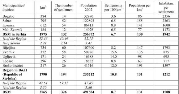
Tab. 1. The main characteristics of Euroregion DSM
Municipalities/
districts km
2 The number
of settlemen.
Population 2002
Settlements per 100 km2
Population per km2
Inhabitan. per settlement
Bogatic 384 14 32990 3.6 86 2356
Sabac 795 52 122893 6.5 155 2363
Loznica 612 54 86413 8.8 141 1600
ali Zvornik 184 12 14076 6.5 77 1173
DSM in Serbia 1975 132 256372 6.7 130 1942
% of the Region 52.46 40.49 52.15 % of Serbia 2.24 2.14 3.41
Bijeljina 734 60 107600 8.2 147 1793
Zvornik 372 58 50776 15.6 136 875
Ugljevik 171 24 16688 14.0 98 695
Lopare 296 26 18632 8.8 63 717
Brcko district 217 26 41516 12.0 191 1597
Region in B&H (Republic of Serbska)
1790 194 235212 10.8 131 1212
% of the Region 47.54 59.51 47.85 % of the Region 3.50 5.86
DSM 3765 326 491584 8.7 131 1508
Note: Dates about population in Republic of Serbska are estimated (The Atlas of the World 2003) and dates for Serbia are presented without Kosovo and Metohija. (Todorovic et al 2004).
Somewhat more significant cities on the hinterland are Šabac, Bijeljina and Brčko, while near Loznica, the double knot Zvornik- Mali Zvornik and on the route Badovinci- Bijeljina, as it has already been mentioned, the Drina river is overbridged, what made the cross-border traffic of people, goods and information much easier and more intensive. All that contributes to the improvement of cooperation between the two republics.
Common interest of both members of the Euroregion is a international cooperation for the purpose of:
• Connecting and improving the common natural resourses and traffic relations, • Delivering the common regional projects,
• Encouraging the cooperation between citizens, public and cultural institutions, • Activating the economy subjects and the potentials of the member republics, • Development of agricultural manufacture,
• Development of ecology,
• Establishing the common interests and the strategic development of the members, • Mutual information exchange,
• Forming the common human rights institutions, • Improving the free passage of people and goods,
• Improving the multicultural relations of the citizens of the members of the Euroregion.
The enviroment for the regional cooperation in the central and upper flow of the Drina River
Not paying attention to the amount and intensity of cooperation between the republics on the opposite sides of the river Drina, to the misunderstandings and antagonisms from the recent past, we find that the cooperation must develop everywhere, both in the central and upper5 flow of the river.
The conditions for the cooperation between the two regions on the opposite sides of the Drina river must be established, studied and confirmed, as a common interest and with the intention of constant expansion and intensification of such cooperation. Some of the basic points of the cooperation are in our opinion the following:
• The positive experiences and cooperation between different regions across Europe and the growing awareness about the overcoming of antagonism and misunderstandings of all sorts.
• The common language is a priceless base for the easy communication and limitless cooperation on the economical, educational, cultural, sporting and every other field. • National, cultural (Grčić Lj., Grčić M. 2007), and economic identities are greatly
balanced and there is no danger of overflowing of the surplus of labour.
• The improvement of the cooperation between the compatible economy branches. • The development of tourism by improving the material basis by means of building
restaurants and hotels, giving support to the further development of popular tourist centers, but also encouraging the smaller and less familiar tourist localities.
• The Drina river, with its estimated energy potential, which is greatly unused, is also a big motive for the cooperation which would include all the communities, when it comes to building hydropower stations; beside its basic function, a hydropower station would balance the flow of the river Drina, it would diminish the erosion, flood peril, it would create the conditions for the development of water sports and the
5
changed image of the landscape would be a base for the development of different kinds of tourism (recreational, fishing, hunting, etc.)6
• The common concern for the quality of water in the Drina basin (Filipović, D., Obradović, D. 2007), will be important for the irrigation, the food industry and will be an important source of drinking water.7
• The protection of the living enviroment should and must be of common interest, if we want the Drina basin to become a recreational area, and it should become one • The cooperation in the division of the public services between the capitals of the two
republics, especially the twin cities and towns, contributes to the more effective work of those services, and all that contributes to the further cooperation,
• The activities involving the building and modernization of all sorts of infrastrucuture systems, especially the roads and highways, etc.
First positive results of the cooperation in the areas on the both sides of the Drina river, of any kind of amount and intensity, should encourage all the social subjects in Serbia and the Serb Republic to follow the path of even wider cooperation. If it is developed to the level of labour division and work specialization, the spending potential of people would increase to a great extent, and that is a final goal of all the activities.
Development and planning of the cross-border cooperation in Podrinje
The development of cross-border cooperation on the both sides of the Drina and the forming of the Euroregion as the official aspect of cooperation in the central and higher area of Podrinje cannot ossur without following the planned course. The spacial intregration through the spacial planning actually means finding the best way to evaluate the spacial elements and standards that connect these regions, and all the activities that have an effect on the improvement of partnership for the sake of successful inclusion in the competions with other European regions. Cross-border cooperation and unique coordinated plans and programmes have a very important part in all that, because they are supposed to increase the level of attractivity of the region.
The application of the integrational planning method, which is regional in character and cross-bordering in aproach will lead to the river Drina becoming the bridge connecting the devided areas. Integrational planning method is an aproach which sees this area as a region and as a system of hydrologic and functional inter-related elements, and it includes the application of ecological, economical and social dimension of the area. That means that the planning of Podrinje must be methodically coordinated with the regional ecological and economical analysis of the basin and the region must be geografically, functionally, organizationally and administratively defined.
In the domain of measures for the development of different types of European regions according to the European standards for regional planning, spacial attention is payed to the bordering regions. It is estimated that the cross-border cooperation is a special challenge for the new members of the Council of Europe, whose bordering regions are marginalized and not fully developed. The development of cross-border cooperation is the basic condition for
6 The Drina has already been dammed and several lakes have been built in its basin- the lakes of Višegrad, Perućac
and Zvornik.
7
the economical development and social cohesion of the bordering regions. Special attention should be payed to the following points (Stefanovic N., 2005):
• The development of the cross-border traffic and telecommunicational structure and public services,
• The cross-border preservation and maintaining usage of the natural resources,
• Following the cross-border dimension in application of the public and private services,
• Unique planning of the cross-border conurbations, cities and populated areas, • Organization of employment in cross-border areas,
• Diminishing the cross-border pollution.
The cross-border cooperation would improve the attractivness of Podrinje region for the further development by means of implementation of planning solutions, which includes the finding of the suitable institutional frame for their realization. Within the local administration there should be managers whose task would be directed to the local economical development. That kind of assignment can be done by agencies or other organizations. Development plans should be made in order to improve local economy and the developing activities should be determined and provided with space, with infrastructural equipment, labour force, etc. The promotion of economic development is achieved by taking adequate measures and giving information about the cities, so that new investors are attracted. Local administration must give out information about the activities which would make the business more profitable, in order to form the smaller companies.
Mutual interests are connected with the creation of common spacial plans, because that is the only possible adequate realization of plan solutions of all kinds. Initiative for the development of the plans would be taken by the subjects on the higher positions in the region or local communities, or cross-border euroregions of Podrinje.
L i t e r a t u r e
Adamović, J. (2004). Gradovi u Podrinju. U Jovan Cvijić i Podrinje. Loznica: Centar za kulturu ”Vuk Karadžić” Djordjević, J. i Panić, M. (2004). Uticaj transgraničnih područja na razvoj Srbije. Glasnik Srpskog geografskog
društva,84(2)
Filipović, D. i Obradović, D. (2007). Stanje životne sredine na teritoriji opštine Loznica – osnove integralne planske zaštite. Glasnik Srpskog geografskog društva, 87 (1), 163-172.
Grčić, Lj. i Grčić, M. (2007). Tradicionalno seosko neimarstvo u kulturnom pejzažu Mačve, Pocerine i Posavine.
Glasnik Srpskog geografskog društva, 87 (1), 149-162.
Nadj, I., Todorović, M. i Tošić, B. (2005). Geografske odlike transgraničnog evroregiona „Dunav-Kereš-Mureš-Tisa“. Glasnik Srpskog geografskog društva, 85 (2), 97-110.
Ristanović, S. (2000). Reka Drina i Podrinje. Beograd: UKAN.
Stefanović, N. (2005). Smernice za primenu vodećih principa održivog prostornog razvoja u izradi prostornih planova u Srbiji. Beograd: Geografski fakultet,magistarska teza
Stojkov, B. (2004). Ka metodologiji prostornog planiranja Podrinja. U Jovan Cvijić i Podrinje. Loznica: Centar za kulturu «Vuk Karadžić»
Stojković, M. (1991). Uticaj odnosa sa susednim zemljama na pogranične krajeve Srbije. U Geografski problemi pograničnih krajeva Srbije, Geografski fakultet, Beograd.
Todorović, M., Tošić, B. i Stojanović, B. (2004). Srbija, evroregioni i evropske integracije. Beograd: Posebno izdanje Geografskog instituta „Jovan Cvijić“ SANU, knj. 63..
Tošić, B. (2000). Prostorno-ekonomska struktura gradova na primeru Valjeva, Šapca i Loznice. Beograd: Geografski fakultet, doktorska disertacija
Vasović, M. (2004). Jovan Cvijić o značaju i perspektivama Podrinja. Jovan Cvijić i Podrinje. Loznica: Centar za kulturu „Vuk Karadžić”
*** (2003). Atlas sveta. Beograd: Večernje novosti
ШИЋ
И ИЋ
И ИУ ИЊУ
,
.
,
. ,
, .
,
, .
ђ , - ,
. ђ
- , ,
, .
, .
.
.
, ,
. џ
.
. ,
, , ,
.
.
,
.
,
. И
, ,