Lakes, reservoirs and ponds, vol. 1-2: 36-48, December 2008
©Romanian Limnogeographical Association
THE LAKES OF THE TRANSYLVANIAN PLAIN: GENESIS,
EVOLUTION AND TERRITORIAL REPARTITION
Victor SOROCOVSCHI
“Babes-Bolyai” University, Faculty of Geography Cluj-Napoca, Romania
svictor@geografie.ubbcluj.ro
Abstract
This article is concerned with the genesis of the Transylvanian Plain lakes’ basins and their evolution in time and space. Natural lakes in this area are reduced in point of their types of geneses (pseudokarst and lanslide lakes) and number. Their evolution in time is quite fast, especially of the pseudokarst lakes. Among the anthropic lakes, the ponds represent the most frequent genetic type, which gives a particular aspect to the landscape of the Transylvanian Plain. They used to be much more numerous in the past than at present. Those whose dimensions are not significant, situated on the tributaries of the main rivers, have a rapid evolution. The anthropic salt lakes formed following the exploitation of salt in the western area of the country had a fast evolution and they are not numerous today.
Keywords: lake, genesis, evolution, repartition, territory
GENERAL CONSIDERATIONS
The Transylvanian Plain represents the least extended unit (3908 km2) of the three great divisions of the Transylvanian Plateau, holding 26 % of this hilly area. Situated in the center-north of Transylvanian Depression, in between the alpine peaks of Căliman Mountain eastwards and Apuseni Mountains in the southwest, the Transylvanian Plain appears as a low hilly region whose land is used mainly in agriculture.
Fig.1. The Transylvanian Plain and their subunits
I. The Someşană Plain: I.1.The Fizeş Plain; I.2. The Sic Hills; I.3.Unguraş Hills; 1.4.Lechinţa Hills.
II. Mureşană Plain: II.1.Sărmaş Plain; II.2.Mădăraş Hills; II.3. Coasta Grindului
(Câmpia Fizeşului, Câmpia Sărmaşului) leaves a special mark on the landscape of these territories.
LAKE GENESIS, EVOLUTION AND REPARTITION
The individualization of the lake basins appeared following the action of natural and anthropic factors. In point of their origin, the lakes that exist on the territory of the Transylvanian Plain belong to two main categories: natural and anthropic. Most of the lakes are associated in complexes; rarely do they appear solitarily.
Natural lakes
Not numerous, the lakes that have a natural origin are solitary, their dimensions and depth are not significant and they are relatively uniform as genesis. In this category are included the lakes resulted following landslides (Dătăşeni Lake), those from the erosion basins situated on the upper course of certain rivulets (Pogăceaua and Zoreni Lake) or from micro-depressions resulted following the melting of the salt and the settling of the area (Ştiucii Lake).
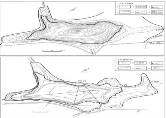
Pseudokarst lakes. In this category, P. Gâştescu (1971) included Ştiucii Lake in Bon Valley, the last tributary on the left of Fizeş River. The lake’s formation through salt melting and settling-subsidence is closely connected to the location of its basin on the diapir visible on the alignment of the localities Dej – Săcălaia – Sic – Cojocna – Turda – Ocna Mureş. Salt is present at the surface on the northern border of the lake, at the salty well of Săcălaia (near the confluence of Săcălaia Valley and Bon ) and at the well dug inside the precincts of the chalet of A.J.P.S. Cluj, on the eastern border of the lake.
Following the significant transport of slope materials, the salt was isolated from the water by means of a tight layer of silt, the salt melting process being stopped. Gradually, the water turned sweet and at present the lake is well populated with fish and invaded by vegetation in a significant area, which increased from 17 ha in 1957 to 27.25 ha in 2000.
Fig. 2. Bathymetric maps of the Ştiucii Lake - 1957 (a) and 2000 (b).
Landslide lakes. The high frequency and intensity of the slope processes favored the individualization of certain lake basins with low surfaces and low depths. In this category are included a few lakes situated in the area of the localities Pogăceaua, Dătăşeni and Archiud.
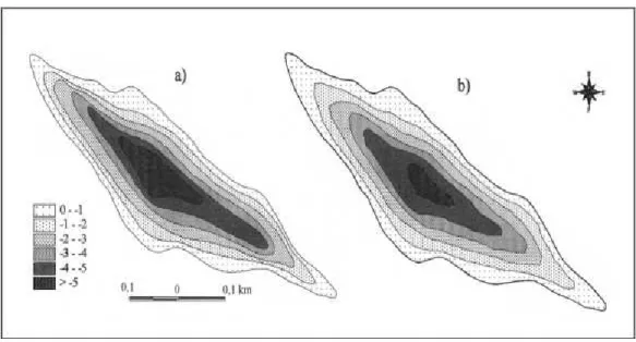
Pogăceaua Lake is situated in the southeast of the Transylvanian Plain in Mădăraş Valley, a tributary on the right side of Comlod, at an absolute altitude of 370 m and a relative altitude of 28 m reported to Fâna elor Rivulet, at whose source is placed the lake. Some unbelievable information about the lake exists since the 19th century, when it was attributed exaggerated depths (Orbán B., 1862).
The Pogăceaua Lake was formed behind the initial landslide-induced wave represented by the Continit Hill (Săndulache Al., 1963). Initially, it seems to have been an endoreic basin, and then the lake began to be drained by the Continit Rivulet, a tributary of the Fâna elor Valley.
a) b)
Fig. 3. Bathymetic maps of the Pogăceaua lake- 1963 (a) and 2003 (b)
DătăşeniLake is situated in the southwest of the Transylvanian Plain, on the right side of the Mureş Corridor, upstream from the mouth of Ranta Rivulet, at a relative altitude of about 100 m reported to Mureş riverbed. After the 34 years period that elapsed between the two measurements (Pop Gr. in 1970 and Şerban Gh., Fodorean I. in 2003), the modifications of the morphometric elements and of the water volumes were not so intense as in the case of the Pogăceaua Lake (fig.4). Probably the lack of a surface network tributary to the lake (even a temporary one) made it harder for the lake to get clogged by alluvial deposits.
Anthropic lakes
On the territory of the Transylvanian Plain there are numerous artificial or anthropic lakes, which can be grouped into two main kinds: artificial salt lakes and ponds.
Anthropic salt lakes.The presence of this genetic type is related to the millenary exploitation, by means of the “bell” or “trapezoidal” mine system, of the salt deposits situated in the diapiric area on the border of the Transylvanian Plateau. The accumulation of the water coming from precipitations and sources from the former salt mines occurred depending on the type of exploitation. The area of this type of lakes is related to the salt quality of the diapiric structure situated on the alignment of the localities Ocna Dej – Săcălaia – Sic – Gădălin - Cojocna - Turda, which determined its exploitation since Dacian and Roman times (Cojocna, Sic, Turda, etc.).
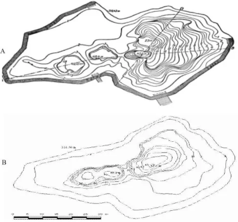
The lake complex from Cojocna is related to the presence of the former salt mines
remained following the exploitation of the salt, which continued in a “bell” system, until the middle of the 19th century (1850-1852), when the mines were closed. The therapeutic valorization of the cold salty water from the holes formed in the salt massif began in the year 1883, when the bases of the Cojocna station are set. Until 1927, it functioned with just one lake, which was arranged as a spa, namely Băilor Lake. Later on, after the filling of the bassinettes formed in this way, other lakes of different dimensions resulted, of which we can distinguish the Durgău (Dőrgő) Lake.
Out of the 11 lakes signaled by T. Pânzaru in 1971 and grouped into two sectors: at present, in the precincts of the station, there are three salt water lakes (Durgău or Toroc, Băilor and Lake no. 2), and in its neighborhood, at the foot of Plop Hill, there are traces of salty or brackish basins which are in an advanced state of clogging, whose depths do not exceed 0.60 m. They provide the station with therapeutic mud.
Compared to the initial situation, there have been essential modifications because of the penetration into the lake of the landslide-induced waves. This led to the shrinking to just half of the surface of the plateau in the western compartment of the lake and a rearrangement of the whole basin. So, under the action of the landslide-induced waves, the basin from the northern sector of the basin was diminished, and now there are just some remains of it, an inclined plateau and a much-enlarged central hole.
The continuation of the salt dissolution process is attested both by the presence of the four holes, and by the accentuated lowering of the thresholds that separate them. So, we notice the unification of the two holes in the southern area of the basin and an extension of the central basin to the expense of the one from the northern area. Some morphometric elements such as length, maximum width and average depth have increased, which proves the fact that the salt melting process is still active.
Fig. 5. Bathymetric map of the Durgău lake (a. according to Pânzaru,T., 1971; b. according to Alexa, M., Şerban,Gh., Sorocovschi, V., 2001)
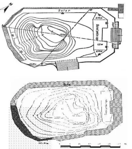
Băilor (Ştrand) Lake, situated in the northwestern extremity of the spa complex
precincts, appeared following the downfall of a bell-shaped salt mine situated at the basis of the western slope of the micro-depression Cojocna. It is the oldest artificial salt lake, and has been arranged for cold baths even since the beginning of the last century (1913).
After the arrangement of the lake, its shape, which was initially that of an ovoid, became hexagonal.
During the interval that elapsed between the two depth measurements, the lake’s basin suffered significant modifications (fig.6).
Fig. 6. Bathymetric map of the Băilor Lake (a. according to T.Pânzaru, 1969; b. according to Alexa, M., Şerban Gh., Sorocovschi, V., 2001)
Lake no. 2, situated behind the station hotel appeared in the small basin resulted
following the downfall, in 1935, of the salt mine exploited in Cojocna. The lake’s outline is almost circular, and the basin is shaped like a cone body.
Compared to the measurements of 1969, almost all of the lake’s morphometric elements have higher values. An exception is the depth, reduced quite a lot, which indicates a slow clogging process. The development of the basin took place very much horizontally, a clear proof in this sense being the lake borders’ aspect of very inclined slope.
Ponds.The ponds are a significant component of the natural landscape in this area, constituting one of the features that provide its geographic individuality compared to the other sub-divisions of the Transylvanian Plateau.
the hydrographic basin of Mureş (55.5 %), a third in the one of Someşul Mic (35.l %) and only one tenth in that of Someşul Mare (9.4 %).
The explanation of the ponds’ genesis took into account the following: the balanced longitudinal profile of the rivers; the narrowing of the valleys as they run across tougher petrographic formations (tuffs, grit stones), landslides and proluvial accumulations; the presence of impermeable deposits on the bottom of the valleys (clays, marls) that prevent the infiltration of the water; the evolution of the hydrographic network (Maxim, I. Al, 1940); the influence of the neo-tectonic structures and movements (Pop, Gh., 1966) and the anthropic activity. During the first stage, the individualization of the lake basins occurred following certain complex natural processes and only later on did the anthropic factor intervene.
In time, the lakes’ number fluctuated. Compared to the several hundreds of lakes mentioned during the Middle Ages, in the 18th century only about 150 remained, of which, by the beginning of our century only 20 were mentioned (H. Sztripszki). So, we can notice their considerable decrease in number.
Following the evolution of the fishpond lakes from the Transylvanian Plain in the interval 1930-1990, we can distinguish several characteristic stages. The first corresponds to the period 1930-1950, when the surface arranged for fishponds was of 270.2 ha (19.3% of the existing total of 1989). The second stage corresponds to the interval 1951-1960, when a surface of 168.2 ha was arranged (12.1% out of the total). During the third stage (1961-1970), this surface increased by 430.9 ha (30.9%). The fourth stage begins with the year 1971, when most of the fishpond lakes are situated on the Fizeş and Luduş Valleys. During the second part of this stage, the ponds and fishponds situated on Chiochiş, Gădălin and Şar Valleys begin to be used. During this stage the fish arrangement increased by 525.5 ha, which represents 37.7 % of the existing total of 1989 (1396.8 ha).
The ponds of the hydrographic basin of Pârâul de Câmpie sum up a surface of 654
ha, which represents 46.8 % out of the total of the fishery arrangements of the Transylvanian Plain. The lake units unfold along the course of Pârâul de Câmpie, beginning from Miheşu de Câmpie to Sânger, on a 20 km distance, as well as on some of its left tributaries (Răzoare I and Răzoare II on Velcheriu Rivulet, Văleni Rivulet and Şăulia I-IV Rivulets on Şes Valley) .
Along the course of Pârâul de Câmpie, from upstream towards downstream, we can enumerate the ponds and fishponds from Miheşu de Câmpie, Bujor I, Bujor II, Zau de Câmpie, Tăureni and Sânger. A comparison of the two measurements (1966 and 1997) highlights a diminution of the values of the maximum depths by 0.27 – 0.52 m, which indicates a quite significant clogging degree for these ponds during the last three decennia.
OnŞesului Valley in 1962 there was only the Şăulia IV Pond, the most extended of
volumes have been buit at the entrance in the system, and between them and the old pond
Şăulia IV, a smaller, buffer-like accumulation was set in place (Şăulia III).
The ponds of Şar hydrographic basin occupy a surface of over 121 ha, representing
about a quarter of the total fishponds arrangements made in Mureş Plain. In 1983-1984 began the use of the ponds from Glodeni II and Glodeni I and in 1985 started to be used those from Toldal, Păingeni I and Păingeni II. From upstream downwards, the ponds are: Ercea, Toldal (35 ha), Păingeni I (32 ha), Păingeni II, Glodeni I (23 ha) and Glodeni II (31 ha).
The ponds in the Fizeş hydrographic basin used to sum up 439 ha, namely 31.4% of
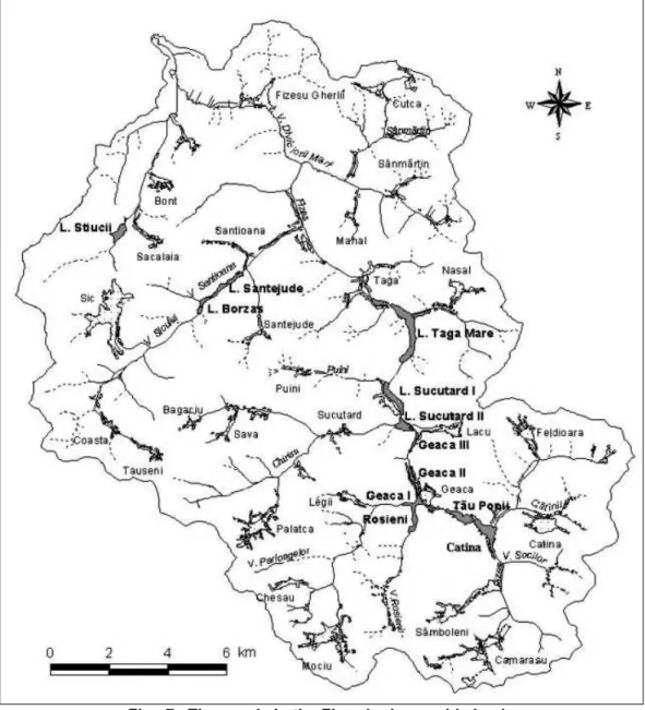
the total fishponds arrangements in the Transylvanian Plain. The ponds in this area, fromupstream downwards, are: Cătina, Tăul Popii, Sf. Florian, Geaca I, Geaca II, Geaca III, Sucutard I, Sucutard II, aga Mare, aga Mică and Ghiol . A few more ponds and fishponds can be found on the tributaries of the Fizeş, like those from Ciortuş Valley (Roşieni), Suciuaş Valley (Năsal), Sic Valley (Borzaş and Sântejude) etc. (fig. 7).
The ponds of the upper basin of Fizeş are situated along the main course of the
river, between the localities Cătina and Sucutard, as well as on some tributaries on the left side: Ciortuş (Roşieni), Mociu (Legii) and Chiriş (Chiriş).
In the fishpond arrangements from Fizeş hydrographic basin, after 1986 occur a series of modifications that influenced to some little extent the morphometric characteristics of the ponds. Modifications occurred as well following the fishpond arrangements made on Fizeş Valley, upstream Geaca I (Sf. Florian) and Ciortuş (Roşieni). The Sf. Florian and the Roşieni Ponds were arranged recently, respectively in 1986, and 1990.
The lake complex situated on the middle course of Fizeş River includes three ponds:
aga Mare, aga Mică and Ghiol . The natural origin of the micro-depression in which the ponds aga Mare and aga Mică lay today is related to the modifications of the valley following the neo-techtonic movements. The micro-depression used to have three compartments, separated by a narrowing and by the alluvial deposits transported by Suciuaş valley almost in the middle of the depression. In time, man intervened a few times and modified the initial parameters. So, by building of an earthen dam in the area of the above-mentioned narrowing, the ponds aga Mare and aga Mică were separated.
The aga Mică pond occupies the compartment downstream from the micro-depression. On the map elaborated by Erődi K. (1908) it does not appear separated from
aga Mare, while on the map of Săndulache Al. (1962) the pond dam of aga Mare is already there. The hydrotopometric measurements made by Pandi G. (1997) show the existence of a land area between aga Mare dam and the upper limit of aga Mică dam.
Ghiol Pond, situated downstream from aga Mică, was arranged in 1975 by building longitudinal dams, which delimited a part of Fizeş riverside.
Fig. 7. The ponds in the Fizeş hydrographic basin
Between the measurements of 1962 and 1997, the ponds’ length increased as the dam was made higher. The average and maximum widths increase in between the first two measurements, and then they remain constant.
The ponds of the Sic hydrographic basin (Borzaş and Sântejude) are situated on the lower course of the rivulet bearing the same name. The presence of the lakes from Sic Valley is mentioned in documents since the 14th century. In the past, Sic riverside, between Sic locality and the confluence with Sântejude Valley, was dominated by swamps and mires. This situation continues today between the locality of Sic and the confluence with Valea Sărată. The anthropic intervention made after 1970 determined the segmentation of the previous lake unit into two distinct sectors.
The Sântejude Lake was much more extended, on a 5.5 km length, between the confluence of Dorna Mare Rivulet and up to 2 km downstream from the confluence with Sântejude Rivulet. The old lake is divided into these two units. From the analysis of the transversal profiles made in the basin of the Sântejude pond becomes narrower and larger, it has been noticed that modifications occurred both concerning the borders and concerning the bottom of the basin.
The ponds of Gădălin hydrographic basin cover an area of 131.6 ha, which
represents 10.8% of the total of the fishpond arrangements made in the Someş Plain. The ponds arranged in 1983 are those from Suatu, Aruncuta and Berchieş.
The ponds of the Meleş hydrographic basin, situated on the course of Chiochiş or
Apatiu, were built in 1979 and cover an area of 131.6 ha, representing 27.7 % of the fishponds arranged in the Someş Plain. Larger are the ponds from Manic and Chiochiş. Concomitantly, there were arranged the fishponds from Manic I, Manic II, Buza and Strugureni (Pop, Gr.1986).
Out of the ponds from the Dipşa hydrographic network, which were much more
numerous in the past, only a few are left on Archiud Valley (Budurleni) and Stupini Valley (Brăteni), a tributary of Lechin a Rivulet. The lakes undergo an intense clogging process and just a little of the water’s surface remained uninvaded by vegetation. Brăteni Lake is bigger, with a surface of 18.3 ha and a maximum depth of 1.62 m (Săndulache, Al.,1970)
Bibliography
Alexa, M., Şerban, Gh. Sorocovschi, V. (2006), Lacurile sărate de la Cojocna (Câmpia Transilvaniei). Evoluţia morfologică şi morfometrică a cuvetelor, SUBB, LI, 2, Cluj-Napoca.
Buta, I., (1958 ), Lacul Cătina, Natura, Seria Geografie-Geologie, 2, Bucurşti.
Buta, I., Săndulache, Al. (1961), Lacurile din bazinul Luduşului, Probleme de Geografie, VIII, Bucureşti.
Erődi, K. (1908), A Mezőség és tavai, (The Transylvanian Field and Your Lakes), Földrajzi közlemények, XXXVI, Budapest
Gâştescu, P. (1963), Lacurile din R.P.Română, Geneză şi regim hidrologic, Editura Academiei R.P.R., Bucureşti
Pânzaru, T. (1971) Complexul lacustru de la Cojocna. SUBB, Series Geographia, 1, Cluj-Napoca.
Pinczés, Z. (1998), Az Erdélyi-medence természeti földrajza, Kossuth egyetemi kiadó, Debrecen.
Pop, P.Gr. (1970), Lacul Dătăşeni – aspecte morfo-hidrografice, in vol. Lucrările Colocviului Naţional de Limnologie Fizică “Geografia Lacurilor”, Bucureşti.
Pop, Gh.(1966), Influenţa structurilor şi mişcărilor neotectonice asupra genezei bazinelor lacustre din Câmpia Transilvaniei, SUBB, Geologie - Geografie, 2, Cluj-Napoca. Săndulache, Al. (1960), Lacurile dulci de la Cătina-Geaca, SUBB, Geologie-Geografie, II,
1, Cluj.
Săndulache Al. (1963), Lacul Pogăceaua, SUBB, Geologie - Geografie, 1, Cluj.
Săndulache, Al., Buta, I. (1963), Câteva date hidrologice asupra lacurilor din bazinul inferior al Fizeşului (Câmpia Transilvaniei). Probleme de geografie, IX, Bucureşti Săndulache, Al. (1970), Lacurile dulci din Câmpia Transilvaniei, Institutul Pedagogic,
Oradea.
Sorocovschi, V.(2005), Câmpia Transilvaniei. Studiu hidrogeografic, Edit. Casa Cărţii de Ştiinţă, Cluj-Napoca.
Sorocovschi V., Şerban Gh., Rus I. (1998). Colmatarea iazurilor din bazinul superior al râului Fizeş, în vol. I “Apa şi protecţia mediului hidric în bazinul mijlociu al Dunării”, Universitatea ” Babeş-Bolyai”, Facultatea de Geografie, IX., Cluj-Napoca.
Sorocovschi, V., Şerban, Gh., Rus, I., Bătinaş, R.(1999), Aspecte privind colmatarea iazurilor de pe valea Luduşului între Miheşu de Câmpie şi Zau de Câmpie, în vol “Geographica Timisensis”, Timişoara.
Sztripszki, H. (1908), Az erdelyi halaszat ismeretehez, (Contribuţii la cunoaşterea pescuitului din Ardeal), Cluj.
Şerban,Gh.V.Sorocovschi, (2003), Lacul Ştiucii-Câmpia Transilvaiei, SUBB, Geogr., XLVIII, 1, Cluj-Napoca.