Assessment of Efficacy among String Quest
K.Manju
1, R. Brindha
2, V. Lathika
3, Mr. A. M. Ravishankkar
4, Mr. T.
Yoganandh
51,2,3
UG Student-Department of CSE Jay Shriram group of institutions, Avinashipalayam, India
4,5Assistant Professor- Department of CSE Jay Shriram group of institutions, Avinashipalayam, India
ABSTRACT
In a large spatial database the work mainly deals with the approximate string search. Particularly we examine the query range append with the string similarity search in both Euclidean space and Road network. We dub this query the spatial approximate string (SAS) query. We propose an approximate solution in Euclidean space, the D-tree which embeds min-wise signatures into an R-tree. The min-wise signature for an index node u keeps a clear representation of the union of q-grams from the sub tree of u. We find the pruning functionality of such signatures based on the set resemblance between the query string and the q-grams from the sub tree of index nodes. We discuss about the estimation of selectivity of a SAS query in Euclidean space, for which we present a novel adaptive algorithm to find the balanced partitions using both the spatial and string information stored in the tree. In Road networks, we propose a novel exact method, RSASSOL, which significantly performs the baseline algorithm. The RSASSOL method partitions the road network, adaptively searches relevant sub graphs, and prunes candidate points using both the string matching index and the spatial reference nodes. The efficiency and effectiveness of our approaches is by the extensive experiments on large real data sets.
Keywords
-Approximate string search, range query, road network and spatial databasesI.
INTRODUCTION
Data mining also known as Knowledge Discovery or Knowledge Discovery in Database (KDD), is the process of extracting or mining the data from large amount of databases. Text mining is one of the applications of data mining which mainly involves the process of extracting interesting information and knowledge from unstructured text documents. Keyword search over a large amount of data is an important operation in a wide range of domains. In spatial databases, wherekeyword search becomes a fundamental building block for an increasing number of real-world applications, and proposed the IR2-Tree. A main limitationof the IR2 -Tree is that it onlysupports exact keyword search. Approximate string search is necessarywhen users have a fuzzysearchcondition, or a spelling error when submitting the query, or the strings in the database contain some degree of uncertainty or error. In the context of spatial search could be combined with any type of spatial queries. In this work, we focus on range queries and dub such queries as Spatial Approximate String (SAS) queries. We denote SAS queries in Euclidean space as (ESAS) queries. Similarly, it extends SAS queries to road networks (referred as RSAS queries).In ESAS, this motivates the need for string matching. A critical component of record matching involves determining whether two strings are similar or not: Two strings are considered matches if their corresponding (string) attributes are
similar. String similarity is typically measured via a similarity function that, given a pair of strings returns a number between 0 and 1 a higher value indicating a greater degree of similarity with the value 1 corresponding to equality. This function is used to perform a similarity join between two input relations that returns pairs of strings whose similarity is above an input threshold.
II.
RELATED WORK
1. INCORPORATING FORMAL STRING
INDEX TRANSFORMATION IN RECORD MATCHING
sub-strings which pass out filter are then verified by checking it. We demonstrate real datasets that approach significantly outperforms both current best exact methods as well as probabilistic methods, that may not identify a small percentage of matching sub-strings.
2. RETRIEVING TOP-K PRESTIGE-BASED
RELEVANT SPATIAL WEB OBJECTS In this paper, the author handles the problem of retrieving web documents which is relevant to query of a keyword within a pre-specified spatial region. There are two stages in query processing. In the First stage, indexing is for the filtration of web document. In the second stage, employed the another index. (e.g.., R-tree). To integrate the R-tree with signature files here a hybrid index structure is proposed. For the purpose of pruning the search space at a query time, both spatial information and text information is utilized by enables the hybrid index structure. However, this proposal is limited by its use of signature files (e.g.., the number of false matches is linear in the collection size and there is no sensible way of using signature files for handling ranking queries). To process a new type of query the combination of R*-tree and bitmap indexing is developed by hybrid index structure is called l-closest keyword query. To enable the efficient processing of the location-aware top-k ranking query, it utilizes both location and text information to prune the search space which integrates the R-tree and inverted files for the IR-tree in hybrid index structure.
3. SELECTIVITY ESTIMATION IN
SPATIAL DATABASES
In this paper, the author proposed a several new techniques for spatial selectivity estimation. These techniques are based on the spatial indices, binary space partitioning, and the novel notion of spatial skew. In database the critical component of query processing is selectivity estimation. For the spatial selectivity estimation there will be a very little work in providing accurate and efficient techniques, despite the increasing popularity of spatial databases. In this domain the relational techniques do not perform well because the spatial data defers from the relational data. From the previously known techniques,the author can able to show that : (a) Sampling and parametric techniques which work well in the relational one-dimensional world do not work well for spatial data. (b) A BSP based partitioning that we call Min-skew outperforms the other
techniques over a broad range of query workloads and datasets.
III.
EXISTING SYSTEM
Approximate string search is necessary when the users have a fuzzy condition search or spelling error when submitting the query. By completely ignoring the spatial component of a query, we evaluate only the string predicate by matching the index which is built as a string in both ESAS and RSAS query to produce a direct solution. The string solution which contains a point is not satisfied by the spatial predicate has been pruned in post processing step after all similar strings has been retrieved.
1) The string solution suffers the same scalability and performance issues as the spatial solution. 2) In existing spatial databases additionally we
answer for SAS query to enable the efficient processing of standard spatial queries which is a spatial-oriented solution.
IV.
PROPOSED SYSTEM
In our proposed system, we divide a roads network G={V,E} into t edge-disjoint sub graphs G1,G2,……,Gt, where t is a user parameter, and for
each sub graph build one string index. From V as reference nodes, we also select a small subset VR of
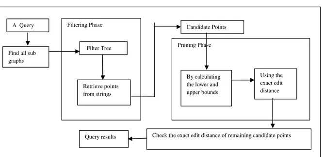
nodes: they are used to prune candidate points/nodes whose distance to query point q are out of query range r. In our RSAS query framework it consists of five steps.
1) We find all the sub graphs which intersect with the query range.
2) To retrieve the points we use the filtration tree of the sub graphs whose string are potentially similar to the query string.
3) We performing the calculation of lower and upper bounds of their distance to the query point, using VR to prune away some of the
candidate points.
4) Between the query string and the strings of candidates the exact edit distance is performing to prune away some further candidate points. After this step, the string predicate has been fully explored.
5) We do the checking process of their exact edit distance to the query point for the remaining candidate points to return those with distance
Figure 1.SYSTEM ARCHITECTURE
In RSASSOL algorithm, we find all the sub graphs that intersect with the query range. Here we
employee the Dijkstra‟s algorithm, that is starting
from the query point q to traverse nodes in G. we analyze that sub graphs for further explorations, whenever this traversal needs the first node of new sub graph. When we reach the boundary of query range automatically the algorithm terminates.To find the points from Gi that may share similar strings to
the query strings, examine theeach sub graph Gi, we
use the approximate string search over Gi‟s filter tree
as the next pruning step. Then using the spatial predicate, we prune the candidate points by computing lower and upper bounds on their distance to q using VR, in a similar way to the ALT algorithm.
Given a candidate point p on an age w=(mi,mj), the
shortest path from p to a reference node mr must pass
through either mi or mj.
Network distance
d(p,mr)=min(d(p,mi)+d(mi,mr),d(p,mj)+d(mj,.mr))
where
d(mi,mr),d(mj,mr) are available from RDISTi and
RDISTj respectively,
d(p,mi) is the distance offset of p to mi which is
available in the adjacency list and the points file of mi,
d(p,mj)=NDIST(mi,mj)-d(p,mi)
where
NDIST(mi,mj) is available in the adjacency list of mi.
We compute d(p,mr) on the fly rather than
explicitly storing the distance between a point and a reference node since the number of points much larger than the number nodes in G. given d(p,mr) and
d(q,mr) for every mrЄVR, we then obtain the distance
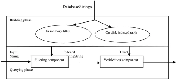
lower and upper bounds between p and q using the triangle inequality. Besides the batch verification, we support one-at-a-time-verification, which implement as follows. Verification model consists of two phases: first, the building phase, second, querying phase. In building phase, we create λ( r ) tuples { id, r, hash_sig, wt} for each dictionary string r and each signature generated by r. Hash code of signature is denoted as hash_sig and wt is the weight of the string r.
A Query
Find all sub graphs
Filtering Phase
Filter Tree
Retrieve points from strings
Candidate Points
Pruning Phase
By calculating the lower and upper bounds
Using the exact edit distance
DatabaseStrings
Figure 2. OVERVIEW OF THE FRAMEWORK
RSASSOL ALGORITHM
1. Find the set X of ids from all the sub graphs 2. Set B = ß ,Bc= ß
3. For each sub graph id j є X do
4. Find all points ids in Ki whose associated strings
α ‟ may satisfy є(α „ ,α) ≤ r using filter tree
5. for every point Pi є Bc do
6. Calculate b+ (pi , q) and b –(pi ,q) as discussed
7 .if b+ (pi ,q) ≤ r then
8. if є (α i ,α) ≤ r then move pi from Bc to B
9. else delete pi from Bc else
if b - (pi ,q) > r then
delete pi from Bc
10. for every point pi є Bc do
11. if є(α i ,α) > r then
12. delete pi from Bc
13. Use the MPALT algorithm to find all points p „s in Bc
14. Return B
Figure 3.SS-JOIN IMPLEMENTATION
In this section, we perform the String Similarity joins using edit distance, which is one of the most common distance functions for string. SS-Joins are closely related to set-containment joins, which has been the main part of several previous works. Generally, similarity joins are closely related to proximity search. The goal is to retrieve thelookup closest object.
APPROXIMATE MEMBERSHIP CHECKING Input: Z,, S =<t1 ,t2...>
1. Build the filter f (Z,) 2. Index Z for verification 3. for (Start= 1 to lZ l – L + 1)
7. if(Э r ε Z, S. t Similarity(r, m)≥ delta)
8. Output m
V.
EXPERIMENTAL SETUP
The system is developed using Java and is used in the system development. MYSQL is used as a back end for this system development. Input to this
project is the user‟s string which is related to the
keyword which already in database.
1) The process of entering the string to collect the exact information about the string.
2) The particular string makes a compare with related strings which is already stored in the database by using the ids.
Building phase
Input Indexed Exact String StringString
Querying phase
In memory filter On disk indexed table
Filtering component Verification component
String(id,str) Compare(id1,id2)
4) At last by applying the Dijkstra‟s algorithm the user can get the exact information for the particular string.
The attention is finally paid to extract the exact information from the database based on the comparison between the strings.
VI.
CONCLUSION
In this paper, we use the edit distance for the string predicate as the similarity measurement. And also address the problem of query selectivity estimation for the queries in Euclidean space. In the selectivityestimation for the query range on road networks where proposed. Even though, they can only able to estimate the number of loads and edges in the range. Future work includes examines the queries of spatial approximate sub-string, designing methods that are more user friendly and solving the selective estimation problem for RSAS queries.
REFERENCES
[1] S. Acharya, V. Poosala, and S. Ramaswamy,
“Selectivity Estimation in Spatial
Databases”, Proc. ACM SIGMOD Int‟l
Conf Management of Data, 1999.
[2] S. Alsubaiee, A. Behm, and C. Li,
“Supporting Location-Based
Approximate-Keyword Queries”, Proc. SIGSPATIAL 18th
Int‟l Conf. Advances in Geographic
Information Systems (GIS), 2010.
[3] A. Arasu, S. Chaudhuri, K. Ganjam, and R.
Kaushik, “Incorporating String
Transformations in Record Matching”, Proc. ACM SIGMOD Int‟l Conf. Management of
Data, 2008.
[4] A. Arasu, V. Ganti, and R. Kaushik,
“Efficient Exact Set-Similarity Joins”, Proc. 32nd Int‟l Conf. Very Large Data Bases (VLDB), 2006.
[5] N. Beckmann, H. P. Kriegel, R. Schneider, and B. Seeger, “The R*-Tree: an Efficient and Robust Access Method for points and
Rectangles”, Proc. ACM SIGMOD Int‟l
Conf. Management of Data, 1990.
[6] X. Cao, G. Cong, and C.S. Jensen,
“Retrieving Top-k Prestige-Based Relevant
Spatial Web Objects”, Proc. VLDB