BGD
10, 7171–7200, 2013Quantifying deciduousness of African rainforests
G. Viennois et al.
Title Page
Abstract Introduction
Conclusions References
Tables Figures
◭ ◮
◭ ◮
Back Close
Full Screen / Esc
Printer-friendly Version Interactive Discussion
Discussion
P
a
per
|
Dis
cussion
P
a
per
|
Discussion
P
a
per
|
Discussio
n
P
a
per
|
Biogeosciences Discuss., 10, 7171–7200, 2013 www.biogeosciences-discuss.net/10/7171/2013/ doi:10.5194/bgd-10-7171-2013
© Author(s) 2013. CC Attribution 3.0 License.
Open Access
Biogeosciences
Discussions
Geoscientiic Geoscientiic
Geoscientiic Geoscientiic
This discussion paper is/has been under review for the journal Biogeosciences (BG). Please refer to the corresponding final paper in BG if available.
Multiresolution quantification of
deciduousness in West Central African
forests
G. Viennois1, N. Barbier2, I. Fabre3, and P. Couteron2
1
Centre National de la Recherche Scientifique (CNRS), UMR AMAP, TA A-51/PS 2, Boulevard de la Lironde, Montpellier Cedex5, 34398, France
2
Institut de Recherche pour le D ´eveloppement (IRD), UMR AMAP, TA A-51/PS 2, Boulevard de la Lironde, Montpellier Cedex5, 34398, France
3
Institut Agronomique N ´eo-Cal ´edonien, Station de Recherche Agronomique de Saint Louis, BP 711, 98810 Mont Dore, New Caledonia, France
Received: 15 February 2013 – Accepted: 4 April 2013 – Published: 23 April 2013
Correspondence to: G. Viennois ([email protected])
BGD
10, 7171–7200, 2013Quantifying deciduousness of African rainforests
G. Viennois et al.
Title Page
Abstract Introduction
Conclusions References
Tables Figures
◭ ◮
◭ ◮
Back Close
Full Screen / Esc
Printer-friendly Version Interactive Discussion
Discussion
P
a
per
|
Dis
cussion
P
a
per
|
Discussion
P
a
per
|
Discussio
n
P
a
per
|
Abstract
The characterization of leaf phenology in tropical forests is of major importance and improves our understanding of earth-atmosphere-climate interactions. The availability of satellite optical data with a high temporal resolution has permitted the identification of unexpected phenological cycles, particularly over the Amazon region. A primary
5
issue in these studies is the relationship between the optical reflectance of pixels of 1 km or more in size and ground information of limited spatial extent. In this paper, we demonstrate that optical data with high to very-high spatial resolution can help bridge this scale gap by providing snapshots of the canopy that allow discernment of the leaf-phenological stage of trees and the proportions of leaved crowns within the canopy.
10
We also propose applications for broad-scale forest characterization and mapping in West Central Africa over an area of 141 000 km2.
Eleven years of the Moderate Resolution Imaging Spectroradiometer (MODIS) En-hanced Vegetation Index (EVI) data were averaged over the wet and dry seasons to provide a dataset of optimal radiometric quality at a spatial resolution of 250 m. Sample
15
areas covered at a very-high (GeoEye) and high (SPOT-5) spatial resolution were used to identify forest types and to quantify the proportion of leaved trees in the canopy. The dry season EVI was positively correlated with the proportion of leaved trees in the canopy. This relationship allowed the conversion of EVI into canopy deciduousness at the regional level. On this basis, ecologically important forest types could be mapped,
20
including young secondary, openMarantaceae,Gilbertiodendron dewevreiand swamp forests. We show that in west central African forests, a large share of the variability in canopy reflectance, as captured by the EVI, is due to variation in the proportion of leaved trees in the upper canopy, thereby opening new perspectives for biodiversity and carbon-cycle applications.
BGD
10, 7171–7200, 2013Quantifying deciduousness of African rainforests
G. Viennois et al.
Title Page
Abstract Introduction
Conclusions References
Tables Figures
◭ ◮
◭ ◮
Back Close
Full Screen / Esc
Printer-friendly Version Interactive Discussion
Discussion
P
a
per
|
Dis
cussion
P
a
per
|
Discussion
P
a
per
|
Discussio
n
P
a
per
|
1 Introduction
Although tropical forests are now widely accepted as an important component of the global carbon cycle, little is known about the actual dynamics of these ecosystems and on their response to the ever-changing constraints of natural and anthropic inputs at temporal scales ranging from ice age to seasonal cycles (Maley, 2009; Richards, 1996).
5
For example, the monitoring of permanent forest plots in the Amazon and Congo basins suggested an ongoing trend where mortality, growth and recruitment rates changed in coherent patterns over the last few decades (Lewis et al., 2009b). The resulting increase in carbon uptake may explain a significant part of the dynamics observed in atmospheric carbon concentrations (Lewis et al., 2009a). This example illustrates the
10
importance of undertaking large-scale and long-term investigations of these relatively poorly known ecosystems. We will focus here on another fundamental aspect of the rates of gas exchange, leaf phenology, which is understood as a temporal and generally cyclical pattern of biological events (in this case, the development and shedding of leaves) over the seasons. The phenology of rainforest trees is notoriously difficult to
15
study. Multi-annual cycles or cases of partial-leaf shedding within a population or even a single crown are frequent (Richards, 1996). The duration of the leafless stage varies significantly, and some trees have no leafless stage (leaf exchanging). Although the timing of leaf abscission or production is sometimes phased with rainfall cycles, this is not a general case in moist forests, and other drivers, such as episodes of lower
20
incoming radiation (light), may be in play (Wright and Van Schaik, 1994). The apparent complexity of individual behaviors and the lack of synchrony within and among species make it difficult to identify patterns of leaf phenology at the stand or landscape level exclusively on the basis of environmental predictors. Field methods allowing an indirect assessment at these scales include the flux tower (Malhi et al., 1998; Saleska et al.,
25
BGD
10, 7171–7200, 2013Quantifying deciduousness of African rainforests
G. Viennois et al.
Title Page
Abstract Introduction
Conclusions References
Tables Figures
◭ ◮
◭ ◮
Back Close
Full Screen / Esc
Printer-friendly Version Interactive Discussion
Discussion
P
a
per
|
Dis
cussion
P
a
per
|
Discussion
P
a
per
|
Discussio
n
P
a
per
|
et al., 2003), whereas higher leaf-litter fall may be concomitant with new leaf flushes. Quantifying patterns of leaf phenology in the forest canopy in a consistent manner over broad regions serves various purposes, including the quantification of gas and energy transfer with the atmosphere or the inference of species composition and structure.
Recent progress in satellite technologies offers new prospects for the large scale
5
monitoring of leaf phenology using daily optical-satellite records (i.e., Hyper-temporal data, e.g., from Moderate Resolution Imaging Spectroradiometer (MODIS) sensors) through the seasonal dynamics of canopy reflectance and composite vegetation in-dices and products such as the Enhanced Vegetation Index (EVI) or the Leaf Area product. These radiometric variations are expected to depend on the canopy structure,
10
relative leaf area, leaf age and physiological status (Huete et al., 2002). These varia-tions may also, less desirably, be due to seasonal changes in the atmosphere, such as aerosol concentrations (Asner and Alencar, 2010), or to uncorrected BRDF effects, such as the seasonal variation in sun height. Despite these potential caveats, unex-pected temporal patterns have been consistently observed over Amazonian forests.
15
In particular, peaks in vegetation indices (EVI and LAI) occurred in phase with cycles of incoming radiation (Bradley et al., 2011; Brando et al., 2010), suggesting that light could be an important limiting factor.
Here again, scale transfer is an issue because a pixel resolution of 1 km at best is typically employed in such studies to ensure the continuity of the temporal data
20
series in areas of high haze and cloud cover frequency. This is two orders of magnitude greater than the size of the reference plots, typically 1 ha or less, that are used for ground-based verification studies. The growing availability of multiscale/multiresolution remote sensing data now allows us to bridge this scale gap. Indeed, although they do not allow continuous monitoring of the phenological cycle, optical data at higher
25
spatial resolutions provide snapshots of the proportion of deciduous trees in the canopy (Bohlman, 2010).
BGD
10, 7171–7200, 2013Quantifying deciduousness of African rainforests
G. Viennois et al.
Title Page
Abstract Introduction
Conclusions References
Tables Figures
◭ ◮
◭ ◮
Back Close
Full Screen / Esc
Printer-friendly Version Interactive Discussion
Discussion
P
a
per
|
Dis
cussion
P
a
per
|
Discussion
P
a
per
|
Discussio
n
P
a
per
|
focused here on a diverse mosaic of forest types straddling the borders of Cameroon, Congo and Gabon, within the Tri National Dja Odzala Minkebe (TRIDOM) landscape. White (1983) classified this area as being in the Guineo-congolese phytogeographic region. Interestingly, according to several authors (Lebrun and Gilbert, 1954; Letouzey, 1985; Schnell, 1970), the climatic conditions of the area are transitional (delineated by
5
1600 mm Mean Annual Precipitation, MAP) between primarily evergreen and primar-ily deciduous forest types. This transition is characterized by a progressive gradient in the density of deciduous trees in the upper canopy rather than a sharp ecotone. Superimposed on the deciduousness gradient is a second gradient of age since per-burbation, with a variety of secondary forests of different maturity levels. A number of
10
regional-scale vegetation maps exist for Central Africa. The earliest were based on photointerpretation (Boulvert, 1986; Letouzey, 1985) or classical phytogeographic ap-proaches (White, 1983). Some of these maps were quite detailed, but interpretation required long years of work using subjective methods, making automation and regional comparisons difficult. More recent approaches were based on combinations of
satel-15
lite optical, LiDAR and/or RADAR (Baccini et al., 2012; Hansen et al., 2008; Mayaux et al., 2004; Saatchi et al., 2011; Verhegghen et al., 2012). Mayaux (2004) and Verheg-ghen (2012), in particular, used the temporal variation in Spot VEGETATION NDVI data to characterize the phenological signatures of different ecosystems across Africa with a 1 km resolution. However, apart from very large swamps, young secondary forests
20
or montane forests, none of these recent large-scale maps has allowed precise dis-tinctions to be made between the different types of dense forests observed on the ground in intermingled patchworks, with sometimes sharp and sometimes progres-sive transitions between each other, forming patterns at both the landscape and the region scale. Compared to previous works that have used medium-resolution optical
25
BGD
10, 7171–7200, 2013Quantifying deciduousness of African rainforests
G. Viennois et al.
Title Page
Abstract Introduction
Conclusions References
Tables Figures
◭ ◮
◭ ◮
Back Close
Full Screen / Esc
Printer-friendly Version Interactive Discussion
Discussion
P
a
per
|
Dis
cussion
P
a
per
|
Discussion
P
a
per
|
Discussio
n
P
a
per
|
and very-high-resolution (0.5 m resolution) data to bridge the scale gap between the stand and MODIS pixel levels and thus reached a quantitative interpretation of the EVI variations in terms of the proportion of leaved trees during the dry season. (3) We distinguished and mapped several dense-forest types based on this quantitative phenological proxy.
5
2 Material
2.1 Study site
The study area covers approximately 141 000 km2of the NW edge of the Congo basin at the borders between the Republic of Congo, Gabon and Cameroon. This area broadly covers the Dja-Odzala-Mink ´eb ´e (Tridom) Landscape (COMIFAC Tridom
in-10
tergovernmental collaboration agreement, 2005), of which approximately 25 % is pro-tected, including seven national parks and one fauna reserve. Geomorphologically, the area sits on a hilly plateau ranging between 300 and 1000 m above sea level, with lo-calized inselberg outcrops. Proximity to the equator induces a bimodal rainfall regime, with two dry seasons centered in January (main season) and July (small season),
total-15
ing four to five dry months, and two wet seasons centered in October and April. Mean annual precipitation ranges from 1600 in the east to 2000 mm in the west. These cli-matic conditions create a transition from mostly evergreen to mostly deciduous forest types (Lebrun and Gilbert, 1954; Letouzey, 1985; Schnell, 1970). At one extreme of the deciduous gradient stand evergreen forests dominated byCaesalpiniaceae.
Gilbertio-20
dendron dewevrei dominated patches are a peculiar case in these forests. Although strikingly mono-dominant evergreen forests are nearly ubiquitous in the center of the Congo basin, they reach the limit of their distribution in the study area, which may partly explain why they mostly occupy lower topographic positions (Letouzey, 1968). At the other extreme are forests dominated byCannabaceae(ex.Ulmaceae, Celtisspp.)
25
BGD
10, 7171–7200, 2013Quantifying deciduousness of African rainforests
G. Viennois et al.
Title Page
Abstract Introduction
Conclusions References
Tables Figures
◭ ◮
◭ ◮
Back Close
Full Screen / Esc
Printer-friendly Version Interactive Discussion
Discussion
P
a
per
|
Dis
cussion
P
a
per
|
Discussion
P
a
per
|
Discussio
n
P
a
per
|
up to 70 % of the upper canopy (Lebrun and Gilbert, 1954). Superimposed on this deciduousness gradient is a second gradient of age since perturbation, with a variety of secondary forests of different maturity levels. In the temporal succession,Musanga cecropioidesis the first tree species to close the canopy. This fast-growing pioneer is progressively outgrown by hemi-heliophilous trees, such as Triplochiton scleroxylon,
5
Alstonia BooneiandTerminalia superba(Schnell, 1970). These latter trees are mostly deciduous, adding to the complexity of forest classification. The older secondary forests can, in some cases, remain in the succession process for a long period of time when the proliferation ofMarantaceae lianas develops in the undergrowth, alone or in com-bination with the activity of large mammals, blocking the regeneration of trees (De
10
Foresta and Massimba, 1990; Letouzey, 1968). These latter forests present a striking gap in the vertical forest stratification, with only scattered tall trees (hence the name open forests) rising to 40 m or so in height and surrounded by the liana layer, which is only a few meters high. Swamp forests typically have various densities ofUappaca paludosatrees, with their characteristic stilt roots, andRaphiapalms. In the NW, stands
15
ofSterculia violaceaare more dominant in swamp forests. At the southern end of the study area lies the northernmost extent of the Bateke savannas and Kalahari sands.
2.2 Imagery
Hyper-temporal information on canopy reflectance was obtained from the MOD13Q1 product (collection 5) of the Moderate Resolution Imaging Spectroradiometer (MODIS).
20
This product is composited every 16 days at a spatial resolution of 250 m and in-cludes the Red (0.62–0.37 µm), NIR (0.841–0.876 µm), Blue (0.459–0.479 µm) and MIR (1.23–1.25 µm) spectral bands as well as the derived “enhanced” vegetation in-dex, or EVI. The EVI (EVI=2.5 (NIR−Red)/(NIR+6 Red−7.5 Blue+1); Gao et al., 2000) optimizes the vegetation signal with improved sensitivity in high biomass
re-25
BGD
10, 7171–7200, 2013Quantifying deciduousness of African rainforests
G. Viennois et al.
Title Page
Abstract Introduction
Conclusions References
Tables Figures
◭ ◮
◭ ◮
Back Close
Full Screen / Esc
Printer-friendly Version Interactive Discussion
Discussion
P
a
per
|
Dis
cussion
P
a
per
|
Discussion
P
a
per
|
Discussio
n
P
a
per
|
250 000 km2. We downloaded all available dates for this tile between January 2000 and December 2011. In spite of atmospheric corrections, the presence of almost perma-nent clouds and haze largely corrupted the data. To generate a good quality composite at a 250 m resolution, we aggregated eleven years of valid data (after filtering for pixel reliability and quality using layers provided with the product) for the EVI index and
5
middle-infrared reflectance (MIR) for both the principal dry season (15 November–15 February, months with less than 100 mm rainfall, consistent with Aragao et al., 2007) and wet season (15 February–15 November). This approach is an important simplifica-tion, that neglects both inter-annual variations in dry season length or severity and the existence of a shorter and less intense dry season centered on July. However obtaining
10
a coherent dataset required finding a compromise between the spatial and the tempo-ral resolution, and we chose here to sacrifice the latter (e.g. as opposed to Bradley et al., 2011). We thus obtained aggregated EVI and MIR images for the wet season and for the main dry season.
We obtained 25 archive SPOT-5 ©CNES images at pre-treatment level 1b (High
15
Resolution, HR) for the main dry season from the CNES-ISIS program. Two particularly cloud and haze-free dry season images (lat 5.14/long 12.97 and lat 3.51/long 16.02) were chosen within this dataset to calibrate quantitative relationships between leafiness and EVI variations. Each image covered an area close to 4000 km2. These images had a pixel size of 10 m and were composed of four spectral bands: Green (0.5–0.59 µm),
20
Red (0.61–0.68 µm), NIR band (0.78–0.89 µm) and MIR band (1.58–1.75 µm).
Four very-high-resolution (VHR) main-dry-season images (GeoEye) were acquired within areas covered by the SPOT-5 image dataset. Each image covers an area of the study area close to 100 km2. The sensor spatial resolution of the multispectral bands (2 m) was improved using a Brovey Pansharpening algorithm (Vrabel, 1996), resulting
25
BGD
10, 7171–7200, 2013Quantifying deciduousness of African rainforests
G. Viennois et al.
Title Page
Abstract Introduction
Conclusions References
Tables Figures
◭ ◮
◭ ◮
Back Close
Full Screen / Esc
Printer-friendly Version Interactive Discussion
Discussion
P
a
per
|
Dis
cussion
P
a
per
|
Discussion
P
a
per
|
Discussio
n
P
a
per
|
and THR images were visually analyzed as color (R-G-B) composites of the Red-NIR-Green bands.
3 Methods
3.1 Mapping of forest types
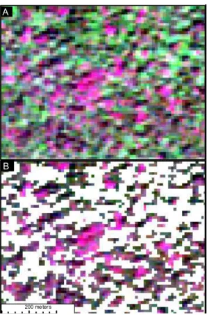
Reference areas were delimited by visual interpretation of pansharpened GeoEye
5
(VHR) images. With a spatial resolution of 0.5 m, these images allowed the discern-ment of forest structural types (Fig. 1) on the basis of general canopy patterns (tex-ture) (Barbier et al., 2010; Couteron et al., 2005) to the level of individual tree crowns (Clark et al., 2005). In addition, the multi-spectral information allowed the discernment of leaved vs. deciduous crowns, which is of paramount importance for this study. It
10
is worth noting that photointerpretation has a long tradition in forestry, including in our study area, where Letouzey (1985) mapped forest types using aerial photogra-phy (1 : 50 000). To expand the training areas, we made use of the intermediate scale offered by the SPOT imagery set. On these HR images, the main forest types were still distinguishable through radiometric variations that could be locally interpreted in
rela-15
tion to the VHR imagery (Fig. 1), but were not reliable enough for large-scale mapping given the numerous (atmospheric, instrumental etc.) sources of radiometric instability. The reference areas obtained were used in a maximum-likelihood, supervised classi-fication applied to the MODIS EVI and MIR (wet season and dry season) composite bands, with the aim to segment broad qualitative forest types over the whole study
20
area, based on both the radiometry and its temporal variation.
3.2 Quantifying leafiness
Deciduous and leaved trees are clearly distinguishable on both VHR and HR images (Fig. 1a and b). In both images, the deciduous crowns are distinguishable mainly be-cause they have high Red reflectance and low NIR reflectance. In the GeoEye images,
BGD
10, 7171–7200, 2013Quantifying deciduousness of African rainforests
G. Viennois et al.
Title Page
Abstract Introduction
Conclusions References
Tables Figures
◭ ◮
◭ ◮
Back Close
Full Screen / Esc
Printer-friendly Version Interactive Discussion
Discussion
P
a
per
|
Dis
cussion
P
a
per
|
Discussion
P
a
per
|
Discussio
n
P
a
per
|
one can clearly distinguish bare branches and twigs (Fig. 1a), whereas in SPOT-5 im-ages, bare crowns are only visible as patches a few pixels wide with high reflectance in the Red band and low response in the NIR band (appearing in pink on the compos-ites presented in Fig. 1b). This spectral property allows deciduous versus leaved trees to be distinguished at multiple spatial scales. A simple, local, radiometric thresholding
5
of the SPOT-5 images was therefore used for the segmentation of the leaved vs. de-ciduous crowns (see Fig. A1). However, radiometric corrections were crucial to insure the consistency of spectral responses within and between images. Large patches of haze, particularly noticeable in the Red band, were removed via a high pass Fourier fil-ter (Niblack, 1986). Radiometric histograms were then aligned between the images by
10
standardization around the mean, under the assumption that forest images had globally similar radiometric amplitude. To separate leaved vs. leafless pixels, threshold values in the Red and NIR bands were carefully selected for each SPOT-5 image using the VHR GeoEye data as a visual reference. Binary masks were thus created and leaved SPOT-5 pixels were counted within areas corresponding to the MODIS 250 m pixels.
15
We used regression to compare the proportion of leaved pixels on SPOT-5 images taken in the dry season against aggregated (2011) dry season EVI values. These cal-culations were used to calibrate a linear-inversion rule for the prediction of forest de-ciduousness over the whole study area.
4 Results
20
4.1 Forest segmentation
Photointerpretation on Red-NIR-Green, very-high-resolution (GeoEye) composites al-lowed a visual discrimination of forest types having contrasting characteristics (Fig. 1). On SPOT-5 composites at a 10 m spatial resolution, differences between forest types were still locally detectable as subtle spectral variations (Fig. 1). This fact allowed the
25
BGD
10, 7171–7200, 2013Quantifying deciduousness of African rainforests
G. Viennois et al.
Title Page
Abstract Introduction
Conclusions References
Tables Figures
◭ ◮
◭ ◮
Back Close
Full Screen / Esc
Printer-friendly Version Interactive Discussion
Discussion
P
a
per
|
Dis
cussion
P
a
per
|
Discussion
P
a
per
|
Discussio
n
P
a
per
|
In more detail, Mixed forests (MF1–4) appeared as a mixture of pinkish, large, bare crowns and branches of emergent deciduous trees and green leaved crowns of other broad-leaved trees, without obvious signs of degradation (Fig. 1a and b). MF were separable from the other types, but less so among themselves, due to the continuous variation in the proportion of leafless crowns.
5
Open forests (OF) were composed of Marantaceae forests with large trees inter-spersed within a light-green, highly photosynthetic matrix of tall herbs and vines (Fig. 1c and d). Tree crowns may in some case form a nearly closed cover, but most often, they let theMarantaceae carpet appear, conditioning a texture characterized by both fine- (undergrowth) and coarse- (isolated crowns) grained patterns on GeoEye imagery
10
(Fig. 1c). Appearance of the undergrowth also tends to produce high reflectance lev-els in the NIR, producing green patches in the SPOT composites (Fig. 1d). Young secondary forests (YSF) in the early post-disturbance stages showed fine-grained tex-ture on GeoEye composites (Fig. 1e). Musanga cecropioides trees tended to form a uniform cover with very high NIR reflectance values (Fig. 1f), while deciduous trees
15
were generally absent. Monodominant Gilbertiodendron dewevrei forests (GDF1–2) presented a typical fine-grained texture, due to the even-size and high-density distri-bution of canopy trees (Fig. 1g and h). Deciduous trees appeared only occasionally. Possibly in relation to low leaf reflectance and pendulous-angle distribution of the dom-inant species, global reflectances in NIR and Red were surprisingly low, as indicated
20
by dark tones on the GeoEye and SPOT composites and by low EVI values in both MODIS seasonal coverages. Swamp forests (SF), were easily recognizable on Geo-Eye images by the dominance ofRaphiaspp. palms with a characteristic star-shaped appearance. In dry season images,Raphiatrees presented low NIR and high Red re-flectances, making them appear leafless, but MIR values were also characteristically
25
low (see Fig. A2).
BGD
10, 7171–7200, 2013Quantifying deciduousness of African rainforests
G. Viennois et al.
Title Page
Abstract Introduction
Conclusions References
Tables Figures
◭ ◮
◭ ◮
Back Close
Full Screen / Esc
Printer-friendly Version Interactive Discussion
Discussion
P
a
per
|
Dis
cussion
P
a
per
|
Discussion
P
a
per
|
Discussio
n
P
a
per
|
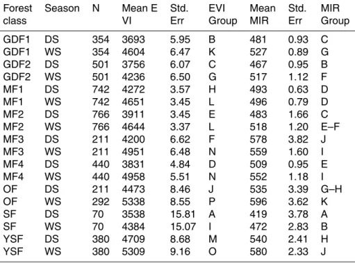
(measured using the Jeffries-Matusita Distance, Richards, 1999) was improved by in-cluding MIR dry and wet season aggregated images. This was particularly important to discriminate swamp forests, as MIR values are significantly lower than any other class, especially in the dry season (Table 1, Fig. A2).
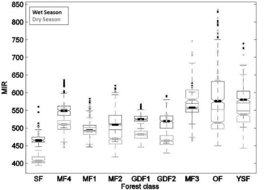
We extracted the spectral signatures of each forest class in the EVI dry season and
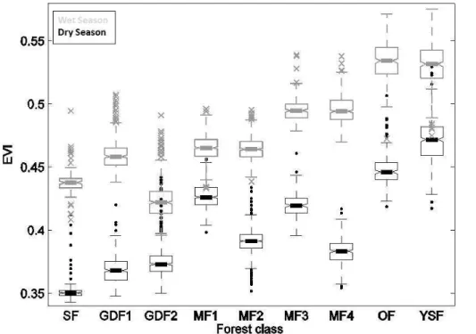
5
wet season aggregated images. The distribution of wet- and dry-season mean EVI val-ues within each forest class is depicted in Fig. 2 with summary distribution statistics (boxplots). Importantly and as expected, mean dry season EVI values were always lower than mean wet season values for all forest types (Fig. 2). A two-factor (sea-son+forest class) analysis of variance was significant (p <0.0001) for both factors
10
tested and for their interaction. Basic assumptions of normality and homoscedasticity were verified. Inter-class and inter-season differences of the mean EVI values were tested using a Newman-Keuls multi-comparison test. All classes and seasons showed very significant differences (p <0.0001) between each other, except for the MF2/MF1 and MF3/MF4 pairs (see Table 1), which were not significantly different in Wet
Sea-15
son. Overall, three broad groups stood out (Fig. 2). The first group contained swamp forests (SF) and monodominantGilbertiodendron dewevrei forests (GDF1 and GDF2) and presented low mean EVI values throughout the two seasons. On the other hand, the group containing open Marantaceae forests (OF) and young secondary forests (YSF) displayed consistently high mean EVI values. The mixed forests (MF1 to MF4)
20
formed a third group presenting intermediate EVI values with noticeable interclass dif-ferences in annual variability. Indeed, EVI distributions became increasingly bimodal (i.e. showing higher difference between the dry and wet season values) from MF1 to MF4, suggesting varying degrees of deciduousness.
4.2 Quantifying and predicting leafiness
25
BGD
10, 7171–7200, 2013Quantifying deciduousness of African rainforests
G. Viennois et al.
Title Page
Abstract Introduction
Conclusions References
Tables Figures
◭ ◮
◭ ◮
Back Close
Full Screen / Esc
Printer-friendly Version Interactive Discussion
Discussion
P
a
per
|
Dis
cussion
P
a
per
|
Discussion
P
a
per
|
Discussio
n
P
a
per
|
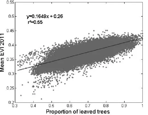
and wet seasons. For each season, these two patterns co-varied in space. The EVI and proportion of leaved pixels varied spatially and temporally in the same way. More quantitatively, a good correlation was obtained between the proportion of leaved pix-els estimated form SPOT-5 dry season images (2011) and mean EVI values averaged over the single 2011 dry season (Fig. 2,n=43 498,R2=0.55, p value<0.05, major
5
axis regression:y=0.1649x+0.26). Slightly different values were obtained when us-ing dry season EVI values averaged for the 2000–2011 period (n=43 498,R2=0.48,
p value<0.05, major axis regression: y=0.1290x+0.30). However, because of the longer averaged period, the latter EVI composite layer proved more stable in terms of radiometric quality (absence of obvious discontinuities) over the study area.
10
We therefore used the 2000–2011 regression coefficients and EVI composite layer to perform a linear inversion of leafiness values over the entire study area. The resulting map, shown in Fig. 5, combined qualitative information for the YSF, OF, GDF, and SF classes and for other non-forest land-cover classes, as well as the values of the quanti-tative leafiness variable within the MF class. The map presents a very coherent spatial
15
structure, with degraded forest types (YSF, OF) primarily located near inhabited local-ities and road networks, GDF and SF forming localized pockets in lower topographic positions, and dry season leafiness values varying over broad regions. Additionally, the most deciduous forests (lower-leafiness values) were primarily located in the driest eastern part of the study area.
20
5 Discussion
Our results show that the mean, dry-season EVI is linearly and positively correlated with the proportion of leaved trees in the canopy, as can be assessed using high-and very-high-spatial-resolution images. This correlation provides strong evidence that a large share of the variability in canopy reflectance summarized in the EVI at stand
25
BGD
10, 7171–7200, 2013Quantifying deciduousness of African rainforests
G. Viennois et al.
Title Page
Abstract Introduction
Conclusions References
Tables Figures
◭ ◮
◭ ◮
Back Close
Full Screen / Esc
Printer-friendly Version Interactive Discussion
Discussion
P
a
per
|
Dis
cussion
P
a
per
|
Discussion
P
a
per
|
Discussio
n
P
a
per
|
displayed the broadest extent and also the largest inter-annual variations in EVI. In addition, our approach allowed mapping of ecologically important forest types that pre-sented consistently high (young secondary forests and open Marantaceae Forests) or consistently low EVI values (Gilbertiodendron dewevrei forests and swamp forests). Another important result concerning the influence of climate drivers is that in all of
5
the forest types identified, the lowest EVI values were observed during the main dry season. This element contrasts with findings from other tropical forests, notably in the Amazon basin, where different relationships between climate and EVI variation were reported. Indeed, over large areas of the Amazon region, the EVI peaked in the dry season, in phase with higher incoming light periods (Brando et al., 2010; Huete et al.,
10
2006; Myneni et al., 2007). However, the dry season is generally very cloudy over West Central Africa (Riou, 1984). Therefore, incoming light levels are higher in the wet sea-son. In other words, it is difficult on correlative grounds to decide whether water or light was the main climatic driver or limiting factor for our study area. It is possible however, that both water and light reach their least limiting levels during the main wet season.
15
In any case, the multi-resolution approach presented here could be easily applied to different contexts, thereby enabling comparisons.
The share of EVI variation that remained unexplained by leafiness values may have come from a number of different sources, including the imperfect temporal match be-tween the data sources. HR and VHR images were opportunistic snapshots through
20
the clouds, whereas a consistent coverage of MODIS data required aggregating data over long periods of time. Additionally, the radiometric (e.g., atmospheric, Bidirectional Reflectance Distribution Function – BRDF) corrections performed over the different datasets were imperfect. For instance, the sun height is not accounted for in MODIS data filtering algorithms (Vermote et al., 2002) despite the fact that this factor varies
25
BGD
10, 7171–7200, 2013Quantifying deciduousness of African rainforests
G. Viennois et al.
Title Page
Abstract Introduction
Conclusions References
Tables Figures
◭ ◮
◭ ◮
Back Close
Full Screen / Esc
Printer-friendly Version Interactive Discussion
Discussion
P
a
per
|
Dis
cussion
P
a
per
|
Discussion
P
a
per
|
Discussio
n
P
a
per
|
variations in canopy structure, leaf age, and flowering and fruiting episodes (Borchert, 1996; van Schaik et al., 1993).
Considering all of these error sources and the known complexity in leaf phenol-ogy within and among tree species in tropical forests (Reich, 1995), the correlation obtained between leafiness values and EVI is surprisingly good and consistent with
5
Bohlman (2010). This correlation is very much in line with the coherent regional pat-terns displayed by the seasonal variations of the EVI. This suggests that stand-level leaf-phenology signatures do indeed exist at large scales, indicating some degree of synchrony in tree phenology (Borchert et al., 2002; van Schaik et al., 1993).
The spatial distribution of leafiness values and of the various forest types we mapped
10
was largely consistent with existing detailed or phytogeographic vegetation maps for the region we studied (Letouzey, 1968; White, 1983). Indeed, we found a gradient in the density of deciduous trees in the upper canopy of mixed forests that decreased from the north west to the south east of the study area, as has been suggested by sev-eral authors (Lebrun and Gilbert, 1954; Letouzey, 1985; White, 1983). Degraded forest
15
types (YSF, OF) were primarily located near inhabited localities and road networks.
Gilbertiodendron dewevrei forests were often located in confined pockets in lower to-pographic positions of the south east of Cameroon, as was observed by Letouzey (1968). Landscape-scale variations, in the form of intermingled mosaics, corresponded to complex biological (i.e., variations in species abundance), environmental
substra-20
tum conditions (Gourlet-Fleury et al., 2011), and historically numerous, ancient settle-ments (Cinnamon, 2003). A comparison of our map with the reference map of Mayaux (2004) (See Fig. A3) illustrates the important gain in detail regarding the discrimina-tion of forest types. The purpose and scale of these maps is different, as the lat-ter map covers the entire continent. However, in Mayaux’s map, all mixed deciduous
25
forests types, as well as open Marantaceae forests, were grouped under unit 40 or “Closed to open broadleaved evergreen or semi-deciduous forest”. Gilbertiodendron
BGD
10, 7171–7200, 2013Quantifying deciduousness of African rainforests
G. Viennois et al.
Title Page
Abstract Introduction
Conclusions References
Tables Figures
◭ ◮
◭ ◮
Back Close
Full Screen / Esc
Printer-friendly Version Interactive Discussion
Discussion
P
a
per
|
Dis
cussion
P
a
per
|
Discussion
P
a
per
|
Discussio
n
P
a
per
|
A quick comparison (not shown) with the benchmark biomass map of Saatchi (Saatchi et al., 2011) showed a generally lower biomass (<150 Mg DM ha−1
) in areas domi-nated by open Marantaceae forests (e.g., in the Congolese region). However, pockets ofGilbertiodendron forests, which should present significantly higher biomass levels (Djuikouo et al., 2010), did not show up on the benchmark map.
5
Numerous field visits performed by some of these authors also provided information for data validation. However, a systematic/statistical analysis of the correspondence between floristic gradients and phenology patterns would require very large datasets that have not yet been gathered. Forest-management inventories could prove useful in this regard (Gond, 2012; Gourlet-Fleury et al., 2011; Maniatis et al., 2011). Another
10
important path that needs to be explored further is the modeling of radiative transfer in 3-D, forest-stand models (Barbier et al., 2011, 2012; Gastellu-Etchegorry, 2008). Even with the crude parameterization of forest structure and surface/volume scattering prop-erties, such models have proven their usefulness for detecting both instrumental and biological sources of variability and perturbation (Barbier et al., 2011). After long-lasting
15
controversy over the possible meaning and caveats of reflectance variations in Amazon canopies (Huete and Saleska, 2010; Samanta et al., 2011), these new research tracks offer exciting opportunities to bridge the scale gap between field observation and large-scale, remotely sensed patterns that are accessible through MODIS imagery. A more rigorous large-scale, quantitative characterization of canopy phenology opens exiting
20
potential for the parameterization of more realistic, dynamic global vegetation models (Bonan, 2008), or for, more generally, the strategic monitoring of forest cover in tropical countries.
Acknowledgements. Spot images where acquired in the framework of theSPOT/Programme
ISIS, Copyright CNES. This research is part of the pilot regional program (PPR) “Global
25
BGD
10, 7171–7200, 2013Quantifying deciduousness of African rainforests
G. Viennois et al.
Title Page
Abstract Introduction
Conclusions References
Tables Figures
◭ ◮
◭ ◮
Back Close
Full Screen / Esc
Printer-friendly Version Interactive Discussion
Discussion
P
a
per
|
Dis
cussion
P
a
per
|
Discussion
P
a
per
|
Discussio
n
P
a
per
|
References
Arag ˜ao, L. E. O., Malhi, Y., Roman-Cuesta, R. M., Saatchi, S., Anderson, L. O., and Shimabukuro, Y. E.: Spatial patterns and fire response of recent Amazonian droughts, Geo-phys. Res. Lett., 34, L07701, doi:10.1029/2006GL028946, 2007.
Asner, G. P. and Alencar, A.: Drought impacts on the Amazon forest: the remote sensing
per-5
spective, New Phytol., 187, 569–578, 2010.
Baccini, A., Goetz, S. J., Walker, W. S., Laporte, N. T., Sun, M., Sulla-Menashe, D., Hackler, J., Beck, P. S. A., Dubayah, R., and Friedl, M. A.: Estimated carbon dioxide emissions from tropical deforestation improved by carbon-density maps, Nat. Clim. Change, 2, 182–185, 2012.
10
Barbier, N., Couteron, P., Proisy, C., Malhi, Y., and Gastellu-Etchegorry, J.-P.: The variation of apparent crown size and canopy heterogeneity across lowland Amazonian forests, Global. Ecol. Biogeogr., 19, 72–84, 2010.
Barbier, N., Proisy, C., V ´ega, C., Sabatier, D., and Couteron, P.: Bidirectional texture function of high resolution optical images of tropical forest: an approach using LiDAR hillshade
simula-15
tions, Remote Sens. Environ., 115, 167–179, 2011.
Barbier, N., Couteron, P., Gastelly-Etchegorry, J. P., and Proisy, C.: Linking canopy images to forest structural parameters: potential of a modeling framework, Ann. For. Sci., 69, 305–311, 2012.
Bohlman, S. A.: Landscape patterns and environmental controls of deciduousness in forests of
20
central Panama, Global. Ecol. Biogeogr., 19, 376–385, 2010.
Bonan, G. B.: Forests and climate change: forcings, feedbacks, and the climate benefits of forests, Science, 320, 1444–1449, 2008.
Borchert, R.: Phenology and flowering periodicity of Neotropical dry forest species: evidence from herbarium collections, J. Trop. Ecol., 12, 65–80, 1996.
25
Borchert, R., Rivera, G., and Hagnauer, W.: Modification of vegetative phenology in a tropical semi-deciduous forest by abnormal drought and rain, Biotropica, 34, 27–39, 2002.
Boulvert, Y.: Carte phytog ´eographique de la R ´epublique Centrafricaine (feuille Ouest-feuille Est) `a 1 : 1 000 000, 1986.
Boyd, D. S. and Petitcolin, F.: Remote sensing of the terrestrial environment using middle
in-30
BGD
10, 7171–7200, 2013Quantifying deciduousness of African rainforests
G. Viennois et al.
Title Page
Abstract Introduction
Conclusions References
Tables Figures
◭ ◮
◭ ◮
Back Close
Full Screen / Esc
Printer-friendly Version Interactive Discussion
Discussion
P
a
per
|
Dis
cussion
P
a
per
|
Discussion
P
a
per
|
Discussio
n
P
a
per
|
Bradley, A. V., Gerard, F. F., Barbier, N., Weedon, G. P., Anderson, L. O., Huntingford, C., Aragao, L. E. O. C., Zelazowski, P., and Arai, E.: Relationships between phenology, radiation and precipitation in the Amazon region, Glob. Change Biol., 17, 2245–2260, 2011.
Brando, P. M., Goetz, S. J., Baccini, A., Nepstad, D. C., Beck, P. S. A., and Christman, M. C.: Seasonal and interannual variability of climate and vegetation indices across the Amazon, P.
5
Natl. Acad. Sci. USA, 107, 14685–14690, 2010.
Chave, J., Condit, R., Muller-Landau, H. C., Thomas., S. C., Ashton, P. S., Bunyavejchewin, S., Dattaraja, H. S., Davies, S. J., Esufali, S., Ewango, C. E. N., Feeley, K. J., Foster, R. B., Gunatilleke, N., Gunatilleke, S., Hall, P., Hart, T. B., Hern ´andez, C., Hubbell, S. P., Itoh, A., Kiratiprayoon, S., LaFrankie, J. V., de Lao, S. L., Makana, J. R., Supardi Noor, M. N.,
10
Kassim, A. R., Samper, C., Sukumar, R., Suresh, H. S., Tan, S., Thompson, J., Tongco, M. D. C., Valencia, R., Vallejo, M., Villa, G., Yamakura, T., Zimmerman, J. K., and Losos, E. C.: Assessing evidence for a pervasive alteration in tropical tree communities, PLoS Biol., 6, e45, doi:10.1371/journal.pbio.0060045, 2008.
Cinnamon, J.: Narrating equatorial African landscapes: conservation, histories, and
endan-15
gered forests in northern Gabon, J. Colonial. Colonial Hist., 4, Project MUSE, 2003.
Clark, M. L., Roberts, D. A., and Clark, D. B.: Hyperspectral discrimination of tropical rain forest tree species at leaf to crown scales, Remote Sens. Environ., 96, 375–398, 2005.
Couteron, P., Pelissier, R., Nicolini, E. A. and Paget, D.: Predicting tropical forest stand structure parameters from Fourier transform of very high-resolution remotely sensed canopy images,
20
J. Appl. Ecol., 42, 1121–1128, 2005.
Djuikouo, M. N. K., Doucet, J. L., Nguembou, C. K., Lewis, S. L., and Sonk ´e, B.: Diversity and aboveground biomass in three tropical forest types in the Dja Biosphere Reserve, Cameroon, Afr. J. Ecol., 48, 1053–1063, 2010.
Farr, T. G., Rosen, P. A., Caro, E., Crippen, R., Duren, R., Hensley, S., Kobrick, M., Paller, M.,
25
Rodriguez, E., Roth, L., Seal, D., Shaffer, S., Shimada, J., Umland J., Werner, M., Oskin, M., Burbank, D., and Alsdorf, D.: The shuttle radar topography mission, Reviews of Geophysics– Richmond Virginia then Washington, 45, RG2004, doi:10.1029/2005RG000183, 2007. De Foresta, H. and Massimba, J. P.: Etude descriptive d’une for ˆet clairsem ´ee `a Marantaceae
dans le Mayombe Congolais, ORSTOM, Raymond Lanfranchi et Dominique Schwartz, 1990.
30
BGD
10, 7171–7200, 2013Quantifying deciduousness of African rainforests
G. Viennois et al.
Title Page
Abstract Introduction
Conclusions References
Tables Figures
◭ ◮
◭ ◮
Back Close
Full Screen / Esc
Printer-friendly Version Interactive Discussion
Discussion
P
a
per
|
Dis
cussion
P
a
per
|
Discussion
P
a
per
|
Discussio
n
P
a
per
|
Gastellu-Etchegorry, J. P.: 3-D modeling of satellite spectral images, radiation budget and en-ergy budget of urban landscapes, Meteorol. Atmos. Phys., 102, 187–207, 2008.
Gond, V.: Climatic control on the structure and functioning or the moist forest in the Congo Basin, Climate Change Deforestation and the Future of African Rainforests, International Conference, Oxford, UK, 4 January, 2012.
5
Gourlet-Fleury, S., Rossi, V., Rejou-Mechain, M., Freycon, V., Fayolle, A., Saint-Andr ´e, L., Cornu, G., Gerard, J., Sarrailh, J. M., and Flores, O.: Environmental filtering of dense-wooded species controls above-ground biomass stored in African moist forests, J. Ecol., 99, 981–990, 2011.
Hansen, M. C., Roy, D. P., Lindquist, E., Adusei, B., Justice, C. O. and Altstatt, A.: A method for
10
integrating MODIS and Landsat data for systematic monitoring of forest cover and change in the Congo Basin, Remote Sens. Environ., 112, 2495–2513, 2008.
Huete, A., Didan, K., Miura, T., Rodriguez, E. P., Gao, X., and Ferreira, L. G.: Overview of the radiometric and biophysical performance of the MODIS vegetation indices, Remote Sens. Environ., 83, 195–213, 2002.
15
Huete, A. R., Didan, K., Shimabukuro, Y. E., Ratana, P., Saleska, S. R., Hutyra, L. R., Yang, W., Nemani, R. R. and Myneni, R.: Amazon rainforests green-up with sunlight in dry season, Geophys. Res. Lett., 33, L06405, doi:10.1029/2005GL025583, 2006.
Huete, A. R. and Saleska, S. R.: Remote sensing of tropical forest phenology: issues and controversies, ISRPS J. Photogramm., 23, 539–541, 2010.
20
Lebrun, J. and Gilbert, G.: Une classification ´ecologique des for ˆets du congo, S ´erie scientifique N◦63., edited by P. de l’institut national pour l’ ´etude agronomique du congo belge, 1954.
Letouzey, R.: Etude phytog ´eographique du Cameroun, Lechevalier, Paris, France, 1968. Letouzey, R.: Notice de la carte phytogeographique du Cameroun au 1 : 500 000 (1985): 2,
M-SM: region afro-montagnarde et etage submontagnard, 27, 1985.
25
Lewis, S. L., Lloyd, J., Sitch, S., Mitchard, E. T. A., and Laurance, W. F.: Changing ecology of tropical forests: evidence and drivers, Ann. Rev. Ecol. Evol. S., 40, 529–549, 2009a.
Lewis, S. L., Lopez-Gonzalez, G., Sonk ´e, B., Affum-Baffoe, K., Baker, T. R., Ojo, L. O., Phillips, O. L., Reitsma, J. M., White, L., Comiskey, J. A. K, Djuikouo, M. N., Ewango, C. E. N., Feld-pausch, T. R., Hamilton, A. C., Gloor, M., Hart, T., Hladik, A., Lloyd, J., Lovett, J. C., Makana,
30
BGD
10, 7171–7200, 2013Quantifying deciduousness of African rainforests
G. Viennois et al.
Title Page
Abstract Introduction
Conclusions References
Tables Figures
◭ ◮
◭ ◮
Back Close
Full Screen / Esc
Printer-friendly Version Interactive Discussion
Discussion
P
a
per
|
Dis
cussion
P
a
per
|
Discussion
P
a
per
|
Discussio
n
P
a
per
|
Maley, J.: A catastrophic destruction of African forests about 2,500 years ago still exerts a major influence on present vegetation formations, IDS bulletin, 33, 13–30, 2009.
Malhi, Y., Nobre, A. D., Grace, J., Kruijt, B., Pereira, M. G. P., Culf, A., and Scott, S.: Carbon dioxide transfer over a Central Amazonian rain forest, J. Geophys. Res., 103, 593–31, 1998. Maniatis, D., Malhi, Y., Saint Andr ´e, L., Mollicone, D., Barbier, N., Saatchi, S., Henry, M.,
Tel-5
lier, L., Schwartzenberg, M., and White, L.: Evaluating the Potential of Commercial Forest Inventory Data to Report on Forest Carbon Stock and Forest Carbon Stock Changes for REDD, Int. J. Forest. Res., Article ID 134526, 13 pp., doi:10.1155/2011/134526, 2011. Mayaux, P., Bartholom ´e, E., Fritz, S., and Belward, A.: A new land-cover map of Africa for the
year 2000, J. Biogeogr., 31, 861–877, 2004.
10
Myneni, R. B., Yang, W., Nemani, R. R., Huete, A. R., Dickinson, R. E., Knyazikhin, Y., Didan, K., Fu, R., Negron Juarez, R. I., Saatchi, S. S., Hashimoto, H., Ichii, K., Shabanov, N. V., Tan, B., Ratana, P., Privette, J. L., Morisette, J. T., Vermote, E. F., Roy, D. P., Wolfe, R. E., Friedl, M. A., Running, S. W., Votava, P., El-Saleous, N., Devadiga, S., Su, Y., and Salomonson, V. V. : Large seasonal swings in leaf area of Amazon rainforests, P. Natl. Acad. Sci. USA, 104,
15
4820–4823, 2007.
Niblack, W.: An introduction to digital image processing, Prentice-Hall International, 1986. Reich, P. B.: Phenology of tropical forests: patterns, causes, and consequences, Can. J. Bot.,
73, 164–174, 1995.
Richards, J. A.: Remote Sensing Digital Image Analysis: An Introduction, Springer-Verlag,
20
Berlin, 1999.
Richards, P. W.: The Tropical Rainforest, Cambridge, 1996.
Riou, C.: Experimental study of potential evapotranspiration (PET) in Central Africa, J. Hydrol., 72, 275–288, 1984.
Saatchi, S. S., Harris, N. L., Brown, S., Lefsky, M., Mitchard, E. T. A., Salas, W., Zutta, B. R.,
25
Buermann, W., Lewis, S. L., and Hagen, S.: Benchmark map of forest carbon stocks in tropical regions across three continents, P. Natl. Acad. Sci. USA, 108, 9899–9904, 2011. Saleska, S. R., Miller, S. D., Matross, D. M., Goulden, M. L., Wofsy, S. C., Da Rocha, H. R., De
Camargo, P. B., Crill, P., Daube, B. C., De Freitas, H. C., Hutyra, L., Keller, M., Kirchhoff, V., Menton, M., Munger, W., Pyle, E. H., Rice, A. H., and Silva H.: Carbon in Amazon forests:
un-30
expected seasonal fluxes and disturbance-induced losses, Science, 302, 1554–1557, 2003. Samanta, A., Ganguly, S., and Myneni, R. B.: MODIS enhanced vegetation index data do not
BGD
10, 7171–7200, 2013Quantifying deciduousness of African rainforests
G. Viennois et al.
Title Page
Abstract Introduction
Conclusions References
Tables Figures
◭ ◮
◭ ◮
Back Close
Full Screen / Esc
Printer-friendly Version Interactive Discussion
Discussion
P
a
per
|
Dis
cussion
P
a
per
|
Discussion
P
a
per
|
Discussio
n
P
a
per
|
Schnell, R.: Introduction a la Phytogeographie des Pays Tropicaux, V.3., 1970.
Tucker, C. J., Grant, D. M., and Dykstra, J. D.: NASA’s global orthorectified Landsat data set, Photogramm. Eng. Rem. S., 70, 313–322, 2004.
Van Schaik, C. P., Terborgh, J. W., and Wright, S. J.: The phenology of tropical forests: adaptive significance and consequences for primary consumers, Ann. Rev. Ecol. Syst., 24, 353–377,
5
1993.
Verhegghen, A., Mayaux, P., de Wasseige, C., and Defourny, P.: Mapping Congo Basin vegeta-tion types from 300 m and 1 km multi-sensor time series for carbon stocks and forest areas estimation, Biogeosciences, 9, 5061–5079, doi:10.5194/bg-9-5061-2012, 2012.
Vermote, E. F., El Saleous, N. Z., and Justice, C. O.: Atmospheric correction of MODIS data in
10
the visible to middle infrared: first results, Remote Sens. Environ., 83, 97–111, 2002. Vrabel, J.: Multispectral imagery band sharpening study, Photogramm. Eng. Rem. S., 62, 1075–
1084, 1996.
White, F. The vegetation of Africa: a descriptive memoir to accompany the UN-ESCO/AEFTAT/UNSO Vegetation Map of Africa, UNESCO, Paris, 1983.
15
BGD
10, 7171–7200, 2013Quantifying deciduousness of African rainforests
G. Viennois et al.
Title Page
Abstract Introduction
Conclusions References
Tables Figures
◭ ◮
◭ ◮
Back Close
Full Screen / Esc
Printer-friendly Version Interactive Discussion
Discussion
P
a
per
|
Dis
cussion
P
a
per
|
Discussion
P
a
per
|
Discussio
n
P
a
per
|
Table 1.Newman-Keuls multi-comparison test after two-factor (season+class) analysis of vari-ance of EVI and MIR.
Forest Season N Mean E Std. EVI Mean Std. MIR class VI Err Group MIR Err Group
GDF1 DS 354 3693 5.95 B 481 0.93 C GDF1 WS 354 4604 6.47 K 527 0.89 G GDF2 DS 501 3756 6.07 C 467 0.95 B GDF2 WS 501 4236 6.50 G 517 1.12 F MF1 DS 742 4272 3.57 H 493 0.63 D MF1 WS 742 4651 3.45 L 496 0.79 D MF2 DS 766 3911 3.45 E 483 1.66 C MF2 WS 766 4644 3.37 L 518 1.20 E–F MF3 DS 211 4200 6.62 F 578 3.82 J MF3 WS 211 4951 6.48 N 559 1.60 I MF4 DS 440 3831 4.84 D 509 0.95 E MF4 WS 440 4958 5.51 N 552 1.18 I OF DS 211 4473 8.46 J 535 3.39 G–H OF WS 292 5338 8.55 P 596 3.62 K SF DS 70 3538 15.81 A 419 3.78 A SF WS 70 4384 15.07 I 472 2.83 B YSF DS 380 4709 8.68 M 540 2.41 H YSF WS 380 5309 9.16 O 580 2.33 J
BGD
10, 7171–7200, 2013Quantifying deciduousness of African rainforests
G. Viennois et al.
Title Page
Abstract Introduction
Conclusions References
Tables Figures
◭ ◮
◭ ◮
Back Close
Full Screen / Esc
Printer-friendly Version Interactive Discussion
Discussion
P
a
per
|
Dis
cussion
P
a
per
|
Discussion
P
a
per
|
Discussio
n
P
a
per
|
GeoEye (0.5 m)
A
B
C
D
E
F
0 10 20 30 40 meters
0 30 60 90 120 meters
H
G
Fig. 1.Characteristics and criteria for visual discrimination of the main forest types on Red-Near Infrared-Green very-high-spatial-resolution GeoEye and high-spatial-resolution SPOT-5 composites acquired in Dry Season.(A, C, E, G): extracts very-high-spatial-resolution GeoEye image (0.5 m pixels).(B, D, F, H): extracts high-spatial-resolution SPOT-5 image (10 m pixels). Footprint of the corresponding GeoEye image appears in the form of white rectangle. (Aand
BGD
10, 7171–7200, 2013Quantifying deciduousness of African rainforests
G. Viennois et al.
Title Page
Abstract Introduction
Conclusions References
Tables Figures
◭ ◮
◭ ◮
Back Close
Full Screen / Esc
Printer-friendly Version Interactive Discussion
Discussion
P
a
per
|
Dis
cussion
P
a
per
|
Discussion
P
a
per
|
Discussio
n
P
a
per
|
A
C
0 2 5005 000 10 000meters A
B
C
D
Leaved trees proportion
Low : 0.31 High : 1
B
D r y s e a s o n W e t s e a s o n
Mean EVI High : 0.5891
Low : 0.2526 Mask of non forests
BGD
10, 7171–7200, 2013Quantifying deciduousness of African rainforests
G. Viennois et al.
Title Page
Abstract Introduction
Conclusions References
Tables Figures
◭ ◮
◭ ◮
Back Close
Full Screen / Esc
Printer-friendly Version Interactive Discussion
Discussion
P
a
per
|
Dis
cussion
P
a
per
|
Discussion
P
a
per
|
Discussio
n
P
a
per
|
GABON
CONGO CAMEROON
Semb Mbomo Djoum
LomiØ
Makoua Ouesso
Makokou
SouankØ
Yokadouma Mindouvou
16 E 16 E
15 E 15 E
14 E 14 E
13 E 13 E
3 N 3 N
2 N 2 N
1 N 1 N
0 0
CAMEROON
CONGO
GABON
GDF2
SF YSF
GDF1
City
Border Leaved trees proportion
Low :0.03 High :0.79
Savana/Cropland
Open water/marshes OF
BGD
10, 7171–7200, 2013Quantifying deciduousness of African rainforests
G. Viennois et al.
Title Page
Abstract Introduction
Conclusions References
Tables Figures
◭ ◮
◭ ◮
Back Close
Full Screen / Esc
Printer-friendly Version Interactive Discussion
Discussion
P
a
per
|
Dis
cussion
P
a
per
|
Discussion
P
a
per
|
Discussio
n
P
a
per
|
200 me ter s B
A
Fig. A1.Thresholding on Red-Near infrared-Green high resolution (SPOT-5) to isolate decidu-ous trees.(A): in SPOT-5 images, bare crowns of mixed forest appear as patches a few pixels wide with high reflectance in the Red band and low response in the NIR (appearing in pink).
BGD
10, 7171–7200, 2013Quantifying deciduousness of African rainforests
G. Viennois et al.
Title Page
Abstract Introduction
Conclusions References
Tables Figures
◭ ◮
◭ ◮
Back Close
Full Screen / Esc
Printer-friendly Version Interactive Discussion
Discussion
P
a
per
|
Dis
cussion
P
a
per
|
Discussion
P
a
per
|
Discussio
n
P
a
per
|
BGD
10, 7171–7200, 2013Quantifying deciduousness of African rainforests
G. Viennois et al.
Title Page Abstract Introduction Conclusions References Tables Figures ◭ ◮ ◭ ◮ Back Close
Full Screen / Esc
Printer-friendly Version Interactive Discussion Discussion P a per | Dis cussion P a per | Discussion P a per | Discussio n P a per |
GABON GABONCAMEROON
CONGO B B A Semb Mbomo Djoum LomiØ Makoua Ouesso Makokou SouankØ Yokadoum a Mindouvou
16 E 16 E
15 E 15 E
14 E 14 E
13 E 13 E
3 N 3 N
2 N 2 N
1 N 1 N
0 0
30 - Mosaic Vegetation/Croplands
40 - Closed to open broadleaved evergreen or semi-deciduous forest 130 - Closed to open s hrubland
160 - Closed to open broadleaved forest regularly flooded (fres h-brack ish water) 210 - Water bodies
Semb Mbomo Djoum LomiØ Makoua Ouesso Makokou SouankØ Yokadouma Mindouvou
16 E 16 E
15 E 15 E
14 E 14 E
13 E 13 E
3 N 3 N
2 N 2 N
1 N 1 N
0 0
CAMEROON CAMEROON
GABON GABON
CONGO CONGO
Open water/marshes Sav ana/c ropland
GDF2 GDF1
SF YSF OF Leaved trees proportion
Low :0.03 High :0.79