Notes on the vegetation of Suriname
1- Vegetation changes in a dammed up fresh water swamp in
NW
Suriname (•)
Abstract
The vegetationnl changes in a newly dam:;·.ed area on the Nanni Creek Basin in NW Suriname are here considered . The effects o f periodical floocüng on the different vegetation types are studied, and the types of succession ocurring at present are described. It is postulated that marsh forests that are now being drowned will be replaced by a Triplaris swamp forest. Peat levels will probably remain constant, as any accumulation of peat during high water seems to be counter-balanced by peat decomposition and destruction by fire during Jow water leveis.
INTRODUCTION
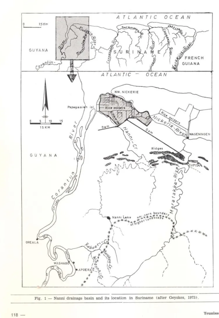
The Nanni Creek in NW Suriname, approxi-mately 150 km long, empties into the Corantijn
River about 12 km south of the settlement of Nieuw Nickerie (fig. 1).
Because the Nanni drainage basin has, for the greater part, a swampy (1) <.haracteristic, and the creek ltself is covered over a long distance with floating vegetationl the entire basin is usually ca lled the Nanni Swamp. Tho Nanni Swamp is bordered in the north-west by the Nieuw Nickerie polder area (2 ), in the north-east by the lower Nickerie River, and it lies between the Corantijn River in the west, the Maratakka River in the east and continues south until the boundary of a higher landscape. The whole drainage basin covers an area of
about
1700 km2•
P. A. Teunissen ("*)
Within the scope of a study on the Hydro-logical behaviour of shal/ow lakes and marshes in sma/1 watersheds in the humid tropics, with
special reference to the Nanni Swamp in Su-riname by Sevenhuysen (l), the present authcr studied the influence of the recently changed hydrological behaviour of the northern Nanni basin on the vegetation . Field work and aerial surveys in this area were carried out on May
25-26. July 29, 1972; Sept. 19-29 and Oct. 17-22. 1973; and Dec. 12-14. 24, 1974.
ENVIRONMENTAL DESCRIPTION OF THE STUDY AREA
In analyzing the factors influencing the vegetation in this part of Suriname, emphasis was placed on landscape (4
). hydrology and fire. For general climatic data of Surinamc see Braak (1935) I Ostendorf (1953-1957) I Lin-deman and Moolenaar (1959) I Schulz (1960). and the "Climatological tables" and "Precipi-tation maps" for Suriname by the Metereologi-cal Service, Paramaribo ( 1960). Comprehensi · ve climato logical and metereological data from the Nanni area in particular will be dealt with by Sevenhuysen (in preparation) .
1 . GENERAL DESCR1PTION OF LANDSCAPES
The northern part ot the Nanni Swamp is located in the recently formed (holocene ) cocstal region of Suriname. In holocene times marine, estuarine and riverain clays and loams
( • l - This lnvestigation was financially supported by The Netherlar.C:s Foundatlon for the Advancement of Tropical Aesearch (WOTRO) .
(* " ) - Suriname Forest Service, Paramaribo, Suriname .
( 1 l - Swamps are areas where the soil stays moist to wet throughout the year and aeration of the soil is perma· nently impeded (Lindeman and Moolenaar, 1959) .
( 2 l - Polders are impouded (impoldered) swampy areas, the water levei of which can be regulated artificially for agricultura! purposes .
( 3 l - R. J . Sevenhuysen, Agricultura! Unlversity, Dept. o f lrrigatlon and Drainage, Wageningen, Holland .
( 4 l - A landsc-ape is an area that as a result of its specific geological orlgin morphologically forms a unit, charac-terlzed by a special rock formation, and a variety of soil condltions and vegetation, typical of this area (Van der Eyk, 1954, 1957).
A T L A
G U YA NA
o 5 10 15
15 KM
G U YANA
N
.
I \
'
\ \' \
\
)
I
~ ----~
----
---~---~~
-- ~~---
---
!___j
Fig . 1 - Nanni drainage basin and its location in Suriname Cafter Geyskes, 1973) .
Landscap es :
So
i
ls :other sh aded
and cross-hatched
11 r e as
ATLANTIC-
OCEAN
Kw•tta landscape
Nickerie l a ndscape
Ridge soils, Rldge flank soils and
Feet
soilsFresh water cl ay swamp soils
Leve e soils
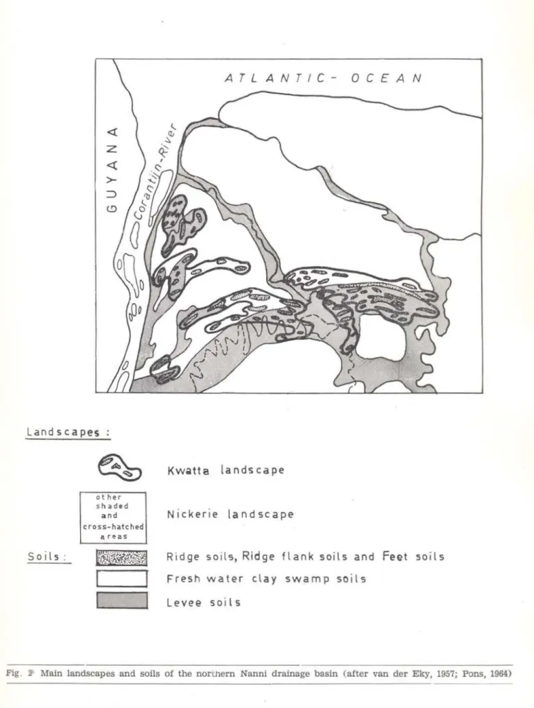
Fig. :& Main landscapes and soils of the northern Nanni drainage basin (after van der Eky, 1957; Pons, 1964}
alternating with sand and shell ridges were deposited on a pleistocene stratum (Brinkman and Pons, 1968).
Two landscapes can be distinguished in the northern Nanni basin (Van der Eyk, 1954, 1957): the Nickerie-landscape or Young sea and river clay landscape, and the Kwata-lands-cape or Ridge landsKwata-lands-cape [fig. 2).
A. Nickerie-landscape
The principal landscape element (5 ) is formed by vast swamps. The soils consist mainly of half ripened to nearly ripened r.lays, mostly without sa lt, to a depth of 1 m (Pons, 1964). The soils are covered with a peat (6
) layer of about 10-30 em thickness (DBK
=
Soil Survey Department Suriname, 1964). These soils are classified as Fresh w ater clay swamps soils (DBK, 1964). Their
vege-tation consists of swamp forest, swamp wood, swamp scrub, or they are covered with a her-baceous swamp vegetation. Another lands·
cape element is formed by marshy (1) river levees along the Corantijn Nanni, Nickerie and
Mar::~takka Rivers. The soils cons ist of neariy
ripened and fully ripened fine sandy, si lty and heavy clays. These soils are classified as River levee soils (DBK, 1964). Their vegetation is a river levee forest.
fhe last landscape element is formed by the periodically submerged mangrove be lts along the lower rivers. The soils are brackish. slightly ripened clays. These are classified as Brackish periodically inundated clay swamp soils (DBK, 1964). These soils are covered by mangrove forest and swamp scrub.
B. Kwatta-landscape
Especially the southern and north-western part of the investigated area is formed by the Kwatta-landscape. The most important ele-ments are fanshaped bundles of ridges: low dry and marshy bodies originated as coastal
bars. The soi ls of the higher parts consist of dry fine sands, class ified as Ridge soils (DBK, 1964) . The marshy parts h ave soi ls o f more or less heavy, f ine sandy loam and are classi-fied as Ridge flank soils and Ridge feet soi ls
(DBK. 1964). Between the ridges interridge-swamps occur. Their soils are fresh water clay swamp soils and Levee Soils (DBK, 1964)
The higher parts of the ridges are as a rule. covered with ridge forest. the flanks and feet are covered with marsh forest, the inter-ridge swamps have swamp forest, swarnp wood, swamp scrub, or an open herbaceous swamp vegetation.
2. HYDROLOGY
The whole Nanni area is hardly accessible and the creek itself is difficult and partly im-possible to navigate because of hcavy floating vegetation. Since early times the area has been visited only by some hunters. fishermen. balata-bleeders and woodcutters. Since 1915 the area around Nieuw Nickerie has been cul-tivated for rice growing. In the early twenties,
people became interested in the Nanni swamp area as a water supp ly for their rice fieicls. In 1920/ 1921, for the first time, a topogrélphic survey of the Nanni Creek, from its mouth ti I! 55 km upstream, was carried out by
to-pographer Sniphout (Geijskes, 1941). In 1926, at about 6 km from its mouth, the so called
Boonacker Dam was built in the Nanni Creek to lead the water via the Roonacker Canal mto the cu lture area (fig. 3). As this area has been enlarged severa! times since, frequently a water deficit occurred, especially with regard to the second rice harvest in relatively dry years. The water supply has been improveci gradually.
In 1936 the whole drainage basin was surveyed by plane by irrigation engineer Van Wouw. In 1939 another reconnaissance flight was carried out by the airplane "Snip" of the Roya l Dutch Airlines (KLM). During that trip
( 5) - A land$Cape element is a smaller unit w ithin a lan dscape. Landscape elements are strongly contrasting in topography, soils and vegetation (Van der Eyk, 1954, 1957).
( 6) - Undecayed organic matter.
( 7 ) - Mars~y soíls ~re inundated part of the year and in the other part they lie well above the ground-water table allowmg aerat10n ot the topsoll, but w ithout dessication (Líndeman and Moolenaar, 1959).
z
~
n>
"'
o=
...
:r (')
< (')
~
~::!;
o
t:S
1\)
~
..
;~·;·.
~
~
r
~
~
"
~
"<
Q:-()
(J
I
\
'
, FIG.3
I •
I /
I I
/ I
,- I
I
I
I
I
/
I
L/"
,
f
'
.,
I I
, /1
SCALE
----
--·
-
---4
r
L4 N
r
Ic
o c
c
4
"'
~
' '
.._' , . ,' • '-•r\.
'I
- - - I
• r-> \
~~ --
..... , • .J - -<. : ~ ~;.:..:( \
'
.
--~..--.
I
'--'·\
'
\ 1I I
, 1 \
---
.../
'
...~ / ....
, .,..<-...
"'-....
f I
-
~--200000
aerial photographs were taken of the higher course of the creek. From ãll these data the lrrigation Service of Nickerie designed a
pre-liminary map of the entire Nanni basin. With the new information they built a new aam called "Nanni Dam" about 6 km further upstream to lead the Nanni water via the "Van Wouw" canal to the culture area. Construction of dam and canal was carried out in 1940/ 1942.
Because the swamp area is very flat, from that time on part of the dammed up water drained away via the surrounding swamp inlo the lower course of the Nanni Creek whi le part of it disappeared east of the Nickerie polders into the Nickerie River. However. since 1942 there is evidence that the water levei has been raised and somewhat stabilized.
Because the poider area was enl:1rged again, the Nanni Dam was improved in 1965, after which a 11 km long "Lekbeteugelingsoam"
(drainage diversion dam) was constructed) from the Nanni dam to the ridge complex of the Corantijn River, to prevent drainage
em+ NP
t:Ho
1040
1020
1000
980
960
!120
900
880
860
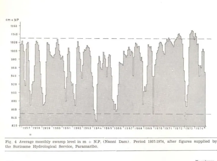
into the lower Nanni River (photo 1). From that time on part of the dammed up water still drained away into the lower Nickerie and Mnré::t3kka Rivers. To prevent this, between 1971 and 1972 a final dam was built in an easterly direction. this time 33 km long. This new dam has improved the water supply con-ciderably. For the first time since hydroiogical dat3 are available (1956), the swamp levei at the Nanni Dam r os e above
+
1 O. 30 m Nickerie Levei (N. P.) which means a water depth o f 1 . 1 O m above peat levei for that lo· cation. The first period of this extremely high swamp levei lasted 25 weeks (March 19-September 9, 1972). At Nanni Dam maxima of+
10.43 (1972),+
10.53 (1973) and+
10.49 m N . P. (1974) were recorded. Seefigo 4 o
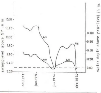
P.s an i llustration o f the recently changed hydrology of the northern Nanni basin, weekly water fluctuations of the swamp on both sides of point A at the easterly dam (fig. 3) are
given below (fig. 5) . Fig. 4 and 5 show that
.
-Fig. 4 Average monthly swamp level in m
+
N.P. (Nanni Dam> . Period 1957-1974, after figures supplied by the Suriname Hydrological Service, Paramaribo.in a relatively short time ali dammed up water can be used for irrigation. At swamp levers lower than
+
9. 80 m N. P. no optimal irri-gation can take place for the entire culture area. At swamp leveis lower then+
9. 20 m N. P. only the Nanni Creek bed still con-tains free water, while the peat layer of the surrounding swamp starts drying out (Se-venhuysen, personal communication).É c
""'
E 10.40 :> <11
c
-
10 20 <11a... <11
z 0. 80 a.
"'
10.00 As > <11> 0.60 o
o ..CJ
.Cl 9.80 l'tS
"'
0.40 L ;"'
> 9.60 a."'
.!!!
0.20 -o
o.
E - 9.40 ~
CIJ
111
o.oo
ru3 ~
lll 9.20
M
...
...
...
.... ... ...
....
"'
~ ~"'
c
u
o
"'
c: ::J..
u"O
Fig. 5 Average weekly swamp leveis and watt..-depths (above peat leve!) at location A (fig . 3)
inside (As) and outside (An) the Nanni drainage basin. Period October 1973- December 1974 . After Sevenhuysen (in preparation).
3. FIRE
Primitive agricultura! methods of the Ame-rindians, who during early times had been living on the higher ridges and levees around the swamp, could have caused burning of swamp vegetation in dry seasons, and of peat in extremely dry seasons. Since 1915 land along the northern edge of the Nanni Swamp is being reclaimed. A common method of removing vegetation and the peat layer from the land is by burning. These fires pushed
by the ever present N. E. trade winds can easily move over a long distance. Since
colo-Notes on the vegetation . . .
nial times , hunters, fishermen , balata-bleeders and woodcutters have visited the areas and a few still do so at this time. To improve th e navigability of the Nanni Creek, it is worthwhile trylng to burn the floating vegetation to the water levei. This method can be especially successfull for grassy mats, which are mostl y mixed with a lot of dead and dry material . This method was, and still is, being practiced Sometimes, for no particular reason except willful destruction. vegetation is burned. In severely dry periods even the peat layer can burn causing extensive swamp woods and swamp forest damage; this is not because of thc burning of the trees but because of the loss of iheir root-subs ~ ~ate which will cause trees t.o fali over.
Bubberman ( 1973) mentions at least
iour
severely dry periods since 190~ during which the vegetation, and also the peat layer, burned over large areas in northern Suriname .
Lindem::m ( 1953) mentions that rather loose stands of herbaceous swamps south of the Nickerie River, near the Maratakka are fairly often destroyed by fire.
Bubberman ( 1973) reports peat and vege· tation fires in the northern part of the Nanni Swamp during the last extremely dry period in 1964. According to the figures of the Hydrological Service (Paramaribo) in 1964 the swamp levei at Nanni Dam came below
+
8.50 m N. P., for the first time since hydrological data have been availa-ble ( 1956). The present author comparedaerial photographs taken during 1947/ 1949 and 1971 / 1972 of the northern swamp area . Between 1947 and 1972 about 55 km2 of closed swamp wood and swamp forest disappeared becZ!use of peat burns. These woods occurred scattered over the whole area in at least
five different concentrations. lt is very plau-sible that the peat layer also burned under-neath the herbaceous swamp vegetation in
between these woods and forests (see map of vegetation and vegetation changes in back flap).
The opinion is gaining ground that for most fresh w:~ter swamps in Suriname which are presently not covered with clímax swamp fcrest, the vegetation has been developed
after one, or repeated burns, by man.
THE VEGETATION
1 . EARLIER VEGETATION STUDIES
In 1933 Lanjouw (1936) visited the southern border of the Waterloo sugar plantation, and made the first botanical collection of the Nanni Swamp along its northern border. This part of the swamp, however, has now been
impoldered.
On request of the lrrigation Service. Geijskes (1941, unpublished) tried to reach the source of the Nanni Creek in 1941, but because of the heavy floating vegetation from the 4th hairpin turn (60 km upstreams) on, he was forced to return without reaching his goal. This trip however can be considered as the first terrestrial biological survey in the northern part of the Nanni drainage basin. In his report Geijskes gives an account ot soil, vege-tation , flora and fauna of the visited area . Some of his observations concerning flora ano vegetation were published !ater (Geijskes. 1945; Ge:jskes and Schols, 1948). A herba-rium collection was made but partly unidenti-fied material was d istributed to herbaria abroad during the Second World War. From his 1941 trip, and aerial surveys in 1942 (Geijskes, 1942. unpublished) and 1946 (Geijskes and Schols, 1948). Geijskes sketched a vegetation map, scale 1 :200.000, .of almostthe entire. Nanni basir. (Geijskes 1946, unpublished). Geijskes placed his unpublished data at the author's disposal. They are used in this paper thanks to his kind
permission.
Early in 1949 Lindeman (Lindeman, 1953: Lindeman and Moolenaar, 1955, 1959) visited the fresh water are.a south of the Nickerie River between the Nieuw Nickerie culture area and
Maratakka River. Lindeman recorded 29 vege-tation plots in this area. Fourteen plots are now lost as a result of impoldering. A
vege-tation map was given. The vegevege-tation types Lindeman (1953) distinguished. however, occur also in the now investigated, somewhat more southei n area.
2. VEGETATION DESCRIPTION (8)
A short description of the vegetation of the northern part of the Nanni Swamp is given below. extracted from above mentioned sources.
Unpublished observations of Geijskes will be dealt with in more detail. The vegetation
un.ts described below are arranged according to the legend of the present map of vegetation and vegetation changes (see back flap) .
A. Mangrove forest, Machaerium lunatum
(branti-mal<aJ ancl Hibiscus tiliaceus
(maho) scrub
Geijskes (1941) mentions Rhizophora man-g/e (mangro). Avicennia nítida (parwa) ancl Acrostichum aureum (tabaka-tiki) along the
Corantijn River and Nanni Creek mouth. Lin-deman (1953) finds Avicennia and Rhizophora
upstream along the Nickerie River until Post Utrecht. Along the Maratakka River the last
Avicennia tree was seen 5 km upstream, the
last Rhizophora tree 10 km upstream.
Between the mangrove trees Machaeriwn lunatum (branti-maka) scrub exists along the
Nanni Creek mouth (Geijskes, 1941) as well as along the Nickerie River and the Maratakb River where it does not quite reach the Ame-rindian village of Cupido (Lindeman, 1953) .
Hibiscus tiliaceus (maho) scrub is
men-tioned by Geijskes (1941) from the Nanni Creek mouth and it was found by Lindeman (1953) in the Cupido-line.
( 8 ) - For the convenience of those readers, who are not acquainted with scientific plant names, local names (if available) are added in brackets . A complete list of species mentioned in text and tables is given as Appendix 1.
B. Herbaceous swamp vegetation
Geijskes ( 1941) remarks that open swamps
~long the lower course of the Nanni Creek,
t n::~t is from its mouth till the first hairpin turn,
have a similar vegetation as the swamps do south of the polders of Nieuw Nickerie. This vegetation consists of herbaceous plants in víhich the giant sedge Cyperus giganteus (paja-grasi l and Cyperus articu/atus (adroen)
àomi-nate. According to Lindeman (1953), this type of vegetation which he describes as Cyperus giganteus-Typha-ScJeria swamps, also occurs
south of the Nickerie River. According to the dominance of one or a few species, he dis-tinguishes various communities. lmportant species are Typha angustifolia (langa-grasi), Cyperus articulatus (adroen), Cyperus gigan-teus (paja-grasi) and Montrichardia arbores-cens (mokomoko). In some places shrubs and
small trees appear in these swamps as a firsi' sign of development into swamp wood arct swamp forest (Lindeman, 1953). ·
Fl0ating vegetation also exists, mainly in creeks. Lanjouw ( 1936) mentions some species of open water and of swamps near Nieuw Nickerie. For the lower course of the Nanni Creek, Geijskes ( 1941) describes f loating vege-tation which grows out from the banks and sometimes covers the total water surface. H e mentions especially two "creek grass" species as dominant in these mats: "bamboe" grass with a loose panicle (9) and "soppoe" grass with a long closed panicle (10). As ac-companying species he gives Ludwigia lepto-carpa and
L.
nervosa and two species of"matro-zenroos" one of which is Hibiscus sororius.
Further, a dull lilac flowering Convolvulaceae (" perhaps lpomoea subrevoluta") and locally
a dark green herb named "Louisa or segodro-wiwiri (11
) are noted. Geijskes also makes mention o f "wara pa" grass (12) from the
mouth of Kamisa and Two Mouth Creeks. From the Nanni Creek further upstream he reports
f loating Montrichardia arborescens mokomoko)
islands with accompr:mying shrubs and lianas, to which Alf•amanda cathartica (Wilkensbita)
and Cydista aequinoctialis belong. Sometimes
these islands contain Pterocarpus officinalis
(watra-bebe) treelets as well. Between the 1slands floating mats of creek grasses are found again with Hibiscus sororius, both Ludwigia species and a Xyris species (13) . The more open patches are covered with Hydro· cctyle umbel/ata (waternavel) , Nymphoides humbo/dtianum and in a few cases with
Len-tibu lariaceae spp.. Lindeman and Moolenaar
( 1959) also make mention of the float ing mats in the Nanrri Creek. They report that thesE: mats sometimes form a solid floating peat layer up to 2 m thick, which occurs over con-siderable stretches of the creek.
C. Swamp scrub
Swamp scrub is not distinguished by Linde-man ( 1953) as a separate vegetation type. Lin-deman ir;cludes swamp scrub wit h his swamp wood, of which he gives the following defi-nition: 10-15 m high vegetation without distinct
stratification of the trees. Swamp scrub is defined here as a woody swamp vegetation consisting predominantly of shrub::. rang ing in height between 2 and 5 m. lt is an intermediate stage between open herbaceous swamps with scattered shrubs and treelets, and swamp wood, which is defined here as a low, open to closed, one story forest, 5-15 m high.
In species composition swamp scrub has an intermediate position between open her-baceous swamps and (low) swamp wood.
D. Swamp wood and swamp forest
Lindeman (1953) mentions open swamp wcods south of the Nickerie River. These oper.
woor!s have a dense undergrowth ciosely
rela-The followíng suggestions are made based upon recent field observations by the present author: ( 9 J - Luzi o la spruceana .
(10) - Saccíolepis striata and/ or Hymenachne amplexicaulís. (11) - Dianthera obtusifolia.
(12) - Laersia hexandra.
( 13) - probably Xyris macrophala.
ted to the vegetation of the open swamps in the vicinity, often with numerous vines
(Lin-deman and Moolenaar, 1959).
Erythrina (kofimama) woods and graves
are mentioned by Geijskes ( 1941) as existiny in the area south of the polders. Besides these, Lindeman also (1953) reports and maps woods of this type south of t he Nickerie River.
Mixed swamp woods, mainly consisting of Pterccarpus officina/is (watra-bebe) and Tabe · buia insignis (zwamp-panta), and also richer
forms w ith Triplaris surinamensis
(mira-·oedoe), Annona glabra (zwamp-zuurzak) and Ficus spp. have been described from the area
south of the Nickerie River between Corantijn and Maratakka River. Triplaris surinamensis
(mira-oedoe) - Bonafousia tetrastachya
(ka-poewatiki) swamp forest (Lindeman and
Moolenaar, 1953. 1959) is mentioned by Li n .. deman (1953) as existing along margins and in depressions of high ridges, on fragments of low ridges, and levees around Nickerie. Lin-deman and Mool enaar ( 1959) mapped
Sym-phonia globulifera (mataki) - Viro/a surinB ·
mensis (baboen) forest south of the Cupido
ridge bundle.
E. Marsh or seasonal swamp forest
Geijskes (1941, 1946, 1948) reports t hese forests along the lower course of the Corantijn River; from the Nanni Creek mouth till the Boonacker Dam; from Kaaiman Creek and the mouths of Kamisa and Two Mouth Creek. Most of the tree species Geijskes reports from these levees are characteristic for this type of forest: Garapa procera (krapa), Ceiba pen tandra (kankantri), Trip/aris surinamensis
(mi-raoedoe), Manilkara bidentata (boletri), Cor-dia tetrandra (tafrabon). Tabebuia insignis var. monophylla (zwamp-panta) and the palms Attalea maripa (maripa) 2), Euterpe o/eracea
pina) and Desmoncus spec. (bambs-maka) .
From the middle course of the Nanni Creek (hairpin turns section) Geijskes reports a richer form of marsh for est, and he adds the following species: Mora excelsa (mora) . Eschweílera sp. (barklak), Tabebuia serratifo·
lia (groenhart), Cedrella odorata (ceder).
126
-Bactris spec. (keskes'maka) and Heliconia bihai (paloeloe). The trees had flood marks
on t he trun ks at one foot high. Lindeman ( 1953) makes mention of marsh fore&t from marshy strips between the drier parts of the Cupido ridge and the levees of Nanni Creek, Maratakka and Nickerie River.
F. Ridge forest
The rea l ridge forest , a poor form of tropi-cal rain forest. is reported by Lindeman (1953) as found on drier parts of the ridges west of the Maratakka River near Cupido.
3. V EGETATION MAP 1972 (see map in back
flap)
After some additional field work and aerial surveys the above mentioned vegetation units (A-F) were mapped at the present scale 1:100.000 f rom aerial photographs scale 1:30.000 infrared (1972). Legend:
A: Mangrove forest, Machaerium lunatum
(b ranti-maka) and Hibiscus tiliaceus
(maho) scrub.
B: Rooting herbaceous swamp vegetat1on, mainly consisting of the Cyperus gigan-teus (paja-grasi) - Typha (langagrasi) -Scleria (baboen-nefi) type and floating
herbaceous swamp vegetation.
C: Swamp scrub.
0: Swamp wood: Erythrina (kofiml'lma) woods
and graves (ER); Pterocarpus
(watra-be-be) - Tabebuia (panta) woods (PT) and
swamp forest: Tripfaris (mira-oedoe) - Bo-nafousia ( kapoewa-ti ki) forest and
Symphonia (mataki) - Viro/a (baboen)
forest.
E: Marsh or seasonal swamp forest.
F: Dryland ridge forest.
This map is also used to show the burned forest areas (period 1948-1972), and drowned forosts (period 1941-1972, 1972-1974).
A more detailed vegetation map of tne whole Nanni drainage basin will be published in the near future in the framework of an inventory of ecosystems in Suriname for the purpose o f nature conservation pol icy.
VEGET ATION CHANGES
1. VEGETATION CHANGES 1941-1972
Studying the already mentioned literatura, vegetation maps and aerial photographs of the area, consiáerable changes in vegetation were found to have taken place between 1941 and
1972, mostly caused by fire (swamp wood and swamp forest), but also by changes of the hydrological behaviour of the swamp (marsh forest).
Geijskes ( 1946, unpubl ished) sketched some levee forests along the Nanni Creek and close to the Kaaiman Creek mouth, ali between the Nanni Dam and the hairpin turns. For the greater part these levee forests were drowned within the period 1941-1972. These forests have been mapped (see map in back f lap) . lhe ir total area is estimated at about 5 km 2 . Photo 1 shows part of the drowned river levee close to the Nanni Dam where the forest has disappeared completely.
2. VEGETATION CHANGES, 1972
On May 25, 1972, after the eastern drainage diversion dam was completed, a boat trip was made through the excavation canal along this dam from the Maratakka River to the Nickerie polder area. During this trip the leved of the swamp at Nanni Dam was extremely high
( )t
+
1 O. 30 m N . P. ) and had been for about5112 weeks. At that time the swamp woods south of the dam were dying. Subsequent te, this trip the Nanni Creek was vis ited from the Nanni Dam up to the Kaaiman Creek mout h. At one place the river was fringed by a narrow strip of dying levee forest. Only some Cordia
trees and Attalea maripa palms seemed to
survive. The levee forest at Kaaiman Creek was also dying.
h. July of the same year the author joined a reconnaissance flight over the Nanni basin. The visible effect of the constructon of the
Notes on the vegetation ...
eastern dam on the vegetation appeared to be limited to the northern part of the drainage basin, i. e. the area north of the Nanni Creek hairpin turns. In that area a lot of swamp scrub and wood and marsh forests (on levees and along the northern edge of the Cupido ridge bundle) were dying. However, along the western part of the dam the swamp woods looked rather healthy on both sides. Here the swamp woods, as was found out later, grow on a somewhat higher elevation. Herbaceous vegetation in between the drowned woody vegetations looked healthy.
3. VEGETATION CHANGES 1973-1974
In Apri l, 1973, WOTRO placed funds at the author's disposal to study the vegetation changec; in detail. In September, 1973, the c0mbined hydrological-vegetational study of the Nanni basin could start.
1 . Selection of sample plots
Along both sides of the eastern drainage diversion dam plots were selected, the study of which could give an idea of the vegetation changes which took place in the past 1V2
years. Herbaceous swamp vegetations and swamp scrub were excluded from the study as they form a very irregular mozaic on both sides of the dam. lt could not be justified to assume that these vegetations on both sides of a certain point at the dam were identical at the time the dam was closed. lt was con-sidered too late to study probable changes in these types of vegetation. Selection of plots was done during a few trips in an air-propeller boat. From the highly elevated chairs it is easy to Jook over the dam. Three "types" of swamp wood and one type of marsh forest cou ld be then recogn!zed.
Along t he western part of the dam:
A. High Pterocarpus-Tabebuia swamp woods
Along the central part of the canal:
B. Low Pterocarpus-Tabebuia swamp woods
(in between Pterocarpus-Tabebuia swamp
scrub and herbaceous swamp vegeta-tion).
Along the eastern end o f the canal:
C. Erythrina swamp woods (in between
11erbaceous swamp vegetation).
O. Marshy ridge forest.
On pair of sample plots (one plot insidFJ and one outside the dammed up swamp, and opposite to each other) was chosen in each of these types as follows. With the aid of the aeri al photographs taken in 1972 a unit of each vE.getation type was chosen which looked homo-geneous in structure, texture and grey tone ,
and which was intersected by the dam. Within each unit a sample plot was chosen. Thi5 was considered the most justified method of selecting pairs of sample plots which werc very probably comparable at the time the dam was constructed and closed. In this way th ~ following plots were selected:
A . Pairs As ( = south) and A n (= north) in + 12 m high Pterocarpus-Tabebuia
swamp wood.
B. Pairs B s and B n in low (± 6-8 m)
Pterocarpus-Tabebuia swamp wood.
C. Paris C s and C n in a more or les closed
Erythrina swamp wood ± 8 m high.
O. Pairs O w ( = west) and O e (
=
east) in closed marshy ridge forest.For location of these plots see vegetation m3p in back flap.
2 . Sample method
In September, and October, 1973 ali plots were sampled as well as possible. At thet
ti me. access to the plots inside the dammed swélmp was rather difficult because, in ad-dition to the discomfort caused by clouds of
mosquitoes, the area was covered with ll
mixture of dead wood, floating pegasse, and water reaching to breast or shoulder height
(see photo 4). In each plot, far enough from the zone influenced by the vegetation of the dam e: nd the excavation canal, a spiral tra-jectory was walked outwardbound until no
new species were observed. The area seen in this manner varied in extent from 100 m2
12A
-(Erythrina swamJ) wood) to SOO m2 (marsh
forest). From the plots the following dat<'l were collected:
a. Number and date of record. b. Stratification.
In each plot outside the dammed up swamp the following strata have been distinguished: one or two tree layer (s) . a shrub-layer, a herb-layer. a layer of rooting and or floating aquatics (if any) . In each plot inside the stor3ge basin: one o r two tree-layer (s) . a shrub-layer, a layer of plants rooting in floo· ting peat and/ or on dead wood and a layer of rooting and/ or floating aquatics. In ali layers. epiphytes, lianas and vines reaching 1hose layers were included.
c. Heigth in m and % of coverage d. List of species per layer
c. Frequency of each species using the following scale :
O
=
Oominant f=
frequentCd = co-domir.ant va = very abundant
a
=
abundant:: =
present+
=
scarce l)=
seen outsidesample plot
f. Growth form and/ or growth stage of each
g.
species: tr
=
tree pm = palmsh
=
shrub he=
herbgh = giant herb
fe = fern ep = epiphyte pn
=
parasitevi
=
vine (herba-ceous)li
=
liana (woody) gr = graminoid pln ~ t aq=
aquaticsi
=
seedlingt
=
deadjv
=
juvenileWater depth, peat thickness in em
h . Oblique aerial photographs and terrestrial photographs were taken.
lf necessary, plant specimens were col lected for identification and herbarium study . Two almost compl ete sets were collected, of which the first has been deposited in the Herbarium of the Surinam Forest Service in Paramaribo and the other in the Botanical Museum and Herbarium of the State University of Utrecht.
3. Description of sample plots
The vegetation plots were described and compared for the first time during the period of September-October, 1973 (see tables A-DJ. In December. 1974, another visit was paid to the plots. In the meantime changes have been
described below.
3.1. Swamp wood
The vegetation changes which took place in A s. B s and C s are well illustrated by comparing tables and photos of A s and A n (Table A, photos 2-5), B s and B n (Table B, photos 6-9) and C s and C n (Table C, photos
10-13).
1!1 this description ali three plot pairs are considered together as the noticeable ch:mges are rather similar, especially in the shrub-layer
and lower layers.
a.
Tree layersIn plot A s most Pterocarpus (watra-bebe;
and Tabebuia (zwamp-panta) trees survive<.l
but crowns became partly deciduous during high water leveis (photo 3). About 10% ot these trees fell over (photo 5) during the period of observation (September 1973) · De-cember 1974) I possibly by weakening of the clay and peat layer in which they root. From the fallen trunks new shoots (photo 3) were
observed in Decemberl 1974. In plot B salmos~
ali Pterocarpus and Tabebuia treelets died
immediately.
In C s the dominating Erythrina (kofimama)
trees survived although their crowns lost many leaves during high water leveis (photo
1 O and 11) . Some trees fell over but im-rnediately started to make new robust suckers in an explosive wayl just like fallen Erythrina
trees react after a peat fire when they alsa fali over. Also root suckers played a role! ir. the ultimately developedl dense undergrowth (photo 12). Trees which still stood upright have survived in another way. Around the trunks, at the height of the high water leve!, floating, corky breathing roots (pneumatopho-res) were observed in Octoberl 1973 (photo
13). These roots bent down during lower
Notes on the vegetation ...
water leveis and developed as prop roots. which were seen for the first time in De-cember, 1974 (photo 14) . Triplaris
(mira-oedoe) . Viro/a (baboen) and Cecropía
(boesi-papaja) trees survived extreme inundation very well . A Ficus tree fell over . Euterpe
(pi-na) palms died after a struggling year with cnly a few leaves left. Eight species of cpiphytes, Phllodendron linnaei, Philodendro11
cf. acutatum, Philodendron pedatum, Philoden-dron jenmanii, Monstera oblíqua, Monstera cf .
expilata, Monstera 14472 and Syngonium vel-/ozianum var. poeppigii (ali Araceae) were
found on both sides of the dam therefore they survived very well . Not so with the lianas
Entada polystachya and Dioclea virgata (pikin
kaw-ai), as they were not seen in the dammed up swamp .
b. Shrub /ayer
Montrichardia arborescens (mokomoko)
and Heliconia marginata (paloeloe) survivea
high inundation; they were recorded on botn sides of the dam. Between September/ October,
1973 and Oecemberl 1974, Montrichardia ar· borescens stems in A s and B s seemt::d to
have increased somewhat as well in numbe:--as in height. In C S1 however, Montrichardia
rece ived strong competition from new Erythri-na glauca (kofimama) shoots (photo 12) .
Four species of the scrub layers from northern plots: Costus arabicus (sangrafoe). Piper di-varicatum and the ferns Acrostichum danaei-folium (tabaka-tiki) and Thelypteris serrata
were not recorded from the southern plots . Epiphytes recorded on both sides of the dam are: Peperomia elongata var. piliramea
lse-cond record from Suriname) and Margraviõ coriacea One unknown vine recorded in the
northern plots was not SP.en in the southern ones .
c. Herb layers
Thirteen spccies were recorded in the northern plots: Euterpe (pina) seedlingsl Heliconia psittacorum (popokai-tongo) I lsch-nosiphon sp. (warimbo) I the grass Panicum
frondescens, the ferns Nephrolepis biserrata
and Blechnum serrulatum, the vines Paullinia
pinnata (fefifinga), Cissus sicyoides, four
unidentified species and the epiphyte Poly-padium ciliatum. Most of these species root
from around and betw een Euterpe stems and Pterocarpus (watra-bebe) buttress roots. Th is
shade-loving herb layer is complete ly absent in the sunny, drowned southern plots.
d. Lõy&r af plants raoting an flaating peat and/ or dead woad
In the southern plots this new layer héld developed instead of a herb layer as c.escribed in c. Only the vi ne Pau/linia pinnata
(fefifinga) and the tern Nephrolepis biserrata
were found in both the herb layer of tne northern plots, and this new layer in the southern ones. Ali other species found on floating pegasse and/ or dead wood are new helophytic pioneers (20 especies) . Thrce shrubs are recorded: Hibiscus bifurcatus
(jorka-okro), Sola num stramonifalium
(bolo-maka) and Fi cus citrifalia. Furthermore, five
broad-leaved herbs were noted: Pluchia adora-ta, Dianthera obtusifolia (segotrowiwiri), He-licania sp. nov. nr. 14484 (paloeloe), Aes-chynamene sensitiva, Ludwigia affinis, the
ferns Thelypteris serrata, the sedges Gyperus
haspan Gyperus pseudodistans, the giant
grass Panicum grande and two creek grasses Luzia/a spruceana and Hymenachne amplexi-caulis. This vegetation is strangled with vines,
of wh ich five species were recorded: Phasealus campestris, lpamaea tiliacea (patata-tite), Gurania spinulasa, Funastrum c/ausum and Me/athria fluminensis (sneki-komkomro).
e.
Layer of aquatic plantsA few specimens of three species of floating aquatic plants, the Nile lettuce Pistia stratiates, and two species of duck weed Spirade/a biperfarata and Lemna minar, were
found in northern plots. Pistia has especially
developed explosively in southern ones. To-gether with the above mentioned species and
Sa/vinia auriculata, Walfiella lingulata and a
few specimens of Geratapteris thalictraides
there, it forms a dense layer on the water surface not occupied with floating pegasses
and dead wood. The water li ly, Nymphaea
130-blanda, has not been recorded from thr.
southern piots.
The thickness of the peat layer in the northern, as well as in the southern, sample plots amounted to 30 em. The fluctuation o f lne water levei and water depth (above peat layer) for plot A n and A s are given in fig. 5. The fluctuations are similar for plot pairs B
and
C,
with the restriction that during high water leveis the water in B s and C s is esti-mated to be 5-15 em deeper than in A s, duo to the former wate rshed between the Nanni Creek and the lv1aratakka River; this is also célused by the inclined water surface goingdown in the direction of the Nanni Dam.
To find out why some swamp woods within the Nanni storage basin still do not seem to be intluenced by the new hydrological be-haviour, a healthy lookmg Pteracarpus Tabe-buia swamp wood along the western part of
the cana l was visited. The swamp wood appeared to grow on
a
somewhat higher elevation (20-40 em measured) .3.2. Marshy ridge fore st
The vegetation changes in D w are illus-trated in Table D and photo 14-17. lnside the dammed up swamp (O w) most trees from both t ree-layers died, such as Manilkara bí· dentata (boletri), Spondias mambin (mope),
older Garapa (krapa) trees and Euterpe (pina)
palms. For other trees in D w it was too late to recognize individual species during the first visit in September, 1973. Trees such as Geiba pentandra (kankantri), the palm Atta/ea maripa
(maripa) , young Garapa (krapa) individuais, Rinaraa pubiflara and Gustavia
(konikoni-oedoe) treelets barely survived the first long period of inundation. Triplaris surinamensis
(mira-oedoe) and Cecropia obtusa (boesi-pa·
paja) resisted it very well. New Triplaris
seedlings carne up, justas often happens when a swamp forest is destroyed by peat fire. A
new shrub and herb-layer developed, tangled with twiners. Jpamaea phi/lomega
(patat!l-tite) developed explosively and by December, 1974, it covered almost the entire herb and Rhrub-layer and even the dead trees (photo 17) .
Triplaris surinamensis (mira-oedoe) seedlings,
however, were able to compete with the new herbs and tanglers. After 13 months the young
Triplaris trees already measured up to 3 meters
in height (photo 17) . The floating aquatics observed in October, 1973, were not seen again in December, 1974.
In May, 1972, the water depths ranged from 65-115 em depending on the distance to the ridge crest. In October, 1973, water depth varied from 40-90 em. In May, June and December, 1974, the soil fel I dry.
4. MAPPING OF ATTACKED AND DROWNED VEGE'l'ATION
From aerial surveys the area containing the attacked and drown swamp scrub, swamp wood, swamp and marsh forest is sketched in the vegetation map (in back flap). Within this area of 190 km2 about 1 O km2 of marsh fores't drowned while another 60 km2 of swamp scrub, swamp wood and swamp forest were severely attacked, or even died.
FUTURE VEGETATION DEVELOPMENT ANO PEAT GROWTH
There are indications that recently drowned marsh forests (now 10 km2) will be succeeded by Triplaris (mira-oedoe) swamp forest.
Most attacked swamp forests (now 60 km2) wi ll not survive because mature trees are
starting to fali over while the natural tree re-generation is being drowned.
A
new her-baceous or shrubby swamp vegetation will possibly develop from this vegetation. Nothing can be said of the speed of vegetational suc-cession towards the new clímax: possibly a two-story swamp forest on a thick peat layer.Vegetational succession is accompanied by peat growth. Since early times, during severely dry periods, the vegetation was damaged locally, and peat was decomposed by fire. This brought the vegetation back to earlier stages of development, while it deepened the swamp and increased the water-storage ca-pacity of the basin.
Notes on the vegetation .. .
Future peat growth depends on future water fluctuations which can be managed now to a certa in degree.
a. After a few weeks with swamp leveis lower than
+
8.50 m N.P. (at Nanni Dam) the upper peat layers dry out to such an extent that their rapid destruction by fire becomes possible.b. At swamp leveis lower than
+
9. 20 mN . P. decomposition of accumui3ted pe~t can take place by aerobic organisms.
c . At swamp leveis between
+
9. 20 m N. P. and+
1 O. 30 m N. P. litter will accumulate and turn into peat.d. After a few weeks with swamp leveis higher than
+
1 O. 30m
N. P. a quickaccumulation of debris can take place as more woody vegetation dies which cause3 an extra quantity of organic matter to fali into the water.
Recapitulating, it can be said that peat growth will be in balance with peat decom-position if decomdecom-position by fire and :iving
decomposers during low water leveis (
<
+
9. 20 m N. P.) compensates for peat accumu-lation durlng high water leveis (
>
+
9.20 m N. p.).Only if the swamp levei will fluctuate élround
+
9. 20 m N. P. for approximately equal time periods above or below this levei, and if leveis>
+
10 . 30 m N .P. can beavoided, peat accumulation and decomposition wi 11 be in balance. Beca use this will not be quite desirable for the water supply, in the long run a net peat growth has to be expected. This peat growth can be measured in permanent plots. lf necessary and in a justified way peat growth can be nullified only by controlled burning.
ACKNOWLEDGEMENTS
This investigation was financially supported by the WOTRO-Foundation. I am much indebted to the Suriname Forest Service for ali
as-sistance given during the fieldwork and the preparation for publication of this article. I would like to thank the following persons: Ir.
F. C. Bubberman and Dr. J. P. Schulz for their permission to cooperate in the hydrologicai project; Drs. M.C.M. Teunissen-Werkhoven and Ms. C.J. Vreden of the herbarium for their
assistance in the field as well as for most taxoncmical identifications; Mr. R. O. de Graav and his staff for drawing the illustrations and Mr. R. N. Kromoidjojo for his photographic work.
I would like to express my special thanks to Dr. O. C. Geijskes of the Rijksmuseum van Natuurlijke Historie at Leiden, Hollsnd, for his willingness to place his manuscripts, maps and photographs at my disposal; also to the Staff of the Botanisch Museum en Herbarium of the State University of Utrecht, Holland for ad-ditional plant identifications. The manuscript was kindly reviewed by Dr. J. C. Lindeman.
I am greatly indebted to Ir. R.J. Sevenhuysen for the fruitful cooperation and to his wife for her Nickerian hospitality. Finally I thank Mr. H. A. Reichart M. Se. for the correction of the English text.
RESUMO
O pântano de Nanni, no Surinarne, é urna. área natural, medindo 1700 km.2. Segundo os dados dis-poníveis, a vegetação e a camada turfosa têm sido fortemente influenciadas pelo fogo. A partir do início deste século, ::> pântano vem sendo usado co-rno fonte de abastecimento de água para a área de rizicultura que circunda a vila de Nieuw Nickerie A medida que a área cultivada foi sendo gradual-mentP ampliada, proporcional deficit de água ocor-reu. Em decorrência disso, o :;uprirnento de água
foi melhorando com a construção de barragem e canais de irrigação, e o comportamento hidrológi-co do pântano alterou-se hidrológi-consideravelmente.
A vegetação paludosa, que ocorre em todos seus estágios de desenvolvimento, desde vegetação paludosa aberta e herbácea até floresta de dois estratos, é limitada por restingas pantanosas e flo-restas de tesos.
Nos últimos anos, cerca de 15 km.2 de floresta brejosa e cerca de 60 km2 de matagal pantanoso, vegetação subflorestal e florestal foram inundados ou severamente influenciados pela elevação extra-ordinária do n.ível das águas. Há indícios rJe que a floresta brejosa seja substituída por certos tipos de floresta pantanosa. Na área subflorestal panta-nosa, severamente afetada pela inundação, a
cama-
132-da herbácea desapareceu (a regeneração natural das árvores incluída), enquanto a camada arbusti-va foi parcialmente alagada. As árvores morreram caíram ou permaneceram desfolhadas durante as grandes inundações. Na superfície aberta de água entre essas árvores, desenvolveu-se uma densa ca-mada de plantas aquáticas. Nas turfas flutuantes e
madeiras mortas, formou-se uma nova vegetação pantanosa herbácea, tolerante à luz. Em alguns ca-sos, árvores de pântano desenvolveram novas bro-tações dos troncos e raízes, enquanto uma das es-pécies formou raízes verdadeiras a partir de raízes respiratórias suberosas.
A sucessão vegetacional, acompanhada de acu-mulação de turfa, continuará se processando en-quanto permaneceram altos os níveis do pântano no futuro. Para que a capacidade de armazanamen-to do pântano não decresça, é aconselhável mane-jar o nível das águas do pântano de tal modo que não permita futura alagação da vegetação paludíco-la lenhosa durante os períodos úmidos, e que, tam-bém, permita a aeração da camada turfosa duran-te o período seco.
São apresentadas tabelas \ias modificações inl-ciais ocorridas a.9ós a inundação e um mapa da ve getação e de mud:mça de vegetação.
LITERATURE CITED
BRAAK,
c.
1935 - The climate of the Netherlar.ds West Indies. Meded. Kon. Ned. Meteor. Inst., 36: 120 p.
BRINKMAN, R. & PoNS, L.J.
1968 - A pedo-geomorphological classification and map of the Holocene eediment,s in the coastal plain of the three Guianas. Soil Survey Paper 4. Wageningen, Ne-therlands Soil Survey Institute. 40 p.
BUOOERMAN, F.C.
1973 - De bosbran::len van 1964 in Suriname. Nw. W. I. Gids, 49 : 163-173.
CENTR"L Bl-RE.\U FOR AERIAL $URVEY, SURlNAME.
Aerial photographs (verticais) Sscale 1:20.000, 1947/49172 - resp. 1:30 .000 of the northern Nanni basin.
1972- Topograpbic Maps, scale 1:100.000, nrs. 1, 2, 9, 10. 5th print.
EYK, J .J . VAN DER
1954 - The landscapes of Northern Surinam (Dutch with English summary). Publ. Centr. Bur. Luchtkaart., Paramaribo,
15:22 .
1957 - Reconnaissance soil survey in Norther.n Surinam. Thesis WageningE'n.
GEIJSKES, D.C.
1941 - De Nannikreek. Reisverslag en resul-taten van een biologisch orderzoek. Unpubl. report. Paramaribo. 45 p. 1942 - Verslag van twee vlíegtochten boven
de Nan.nikreek in Nickerie op 18 sep-tember. Unpubl. report Paramaribo. 13p. 1945 - Plants of the Surinam Coastland. Some observations on the littoral vegetation of Dutch Guiana. Journ. N. Y. Bot. Garden, 46:229-236.
1946 - Schetskaart (schaal 1:200 .000) van ue vegetatie in het stroomgebied van de Nannikreek. Unpubl. map. Parnmaribo. 1973 - Reisverslag van de Expeditie West Suriname 1971 . Zool. Bijdr. Leiden, 15:1-41.
GEIJSKES, D.
c.
& SCHOLS, H.1S48 - Topografische observaties bij twee verkenningsvluchten boven Noordelijk Suriname. Tijdchr. K. N. A. G. ser. 2, 65:342-353.
LANJOUW, J.
1936 - Studies of the Suriname savannahs and swamps. Ned. Kruidk. Arch., 46:823·851.
LlNDEMAN, J.C.
1953 - The vegetation of the coastal region of Suriname. The Veg. of Sur. I.l. Meded. Bot. Mus. Herb. Utrecht, 113:1-135.
Ll:-!DEMAN, J.C. & MOOLENAAR, S.P.
1955 - Voorlopig overzicht van de bostypen in
het noordelijk deel van Suriname. Pa· ramaribo, Ed. Surinam Forest Service. 55 p .
•
Notes on the vegetation ...
1959 - Preliminary survey of the vegetation
types of northern Surinam. The veg. or Sur. I. 2. Meded. Bot. Mus. Herb. Utrecht, 159:1-45.
METEREOLOOJCAL SERVICE, SURINAME
1960 - Precipitation maps and Climat.ological tables. Paramaribo.
ÜSTENDORF, F.
w .
1953/ 57 - Ons klimaat 1-8. De sur. Landbouw 1-5.
PONS, L.J .
1964 - Rapport bij een geomorfologische bodemka.art van de kustvlakte van
Su-riname. Schaal 1:500 . 000. So!l Survey Department, report, 14-3:1-19.
1966 - Geogenese en pedogenese in ele jong--holocene kustvlakte van de drie
Guia-nas. 'l'ijdscbr. K.N.A.G., (2) :153-172.
SEVENHUYSEN, R.J.
- Hydrological behaviour of sballow Iakes and marshes in small watersheds in the humid tropics, \vith special referen· ce to the Nanni Swamp in Suriname (in preparation).
SCHULZ, J. P .
1960 - Ecologícal studíes on raín r:c.rest in northern Suriname The Veg. of Sur. II. Verhand. Kon. Ned. Akad. Wetensch ard. Natuurk. ser. 2., 53(1):1-267 Meded.
Bot. Mus. Herb. Utrecht, 163.
SOIL SURVEY DEPARTMENT, SURINAME
1964 - Overzichts-bodemkaart Henar-Maratak-ka (Cupido) District Nickerie. schaal 1:10.000. Paramaríbo.
APPENDIX I
LIST OF SPECIES ~lENT IO NED IN 'fEXT ANO TABLES
A preliminary list of species of the northern Nanni Swamp based on herbarium specimens,
lite-rature and sight records is available on request from tllc Herbarium of the Suriname Forest Servi-ce, P O B 436, Paramaribo, Suriname.
PTERIDOPHYTA
Parkeriaceae
Ceraiopteris thalictroides (L.) Brongn.
Polypodiaceae
Acrostichum aureum L.
Acro ~ tlchum danaeifolium Langsd, et Fish.
Bleohnum serrulatum L. C. Rich. Neuhrolepis biserrata (Sw.) Schott Polypodium ciliatum Willd.
Tectaria incisa Cav.
Thelyptcris serrata <Cav.) Alston Salviniaceae
Azolla caroliniana Willd. Sah.inia auriculata Aubl.
SPERMATOPHYT A
Acanthaceae
Dianthera obtusifolia (Nees) Griseb. Anacardiaceae
Spondias mombin L. Annonaceae
Annona glabra L. Apocynaceae
AIJamanda cathartica L.
Bonafousia tett·astachya (H .n.K . ) Mgf. Araceae
Anthurium sp.
Monstera cf. expilata Schott Monstera obliqua Miq.
~lonstera. pertusa (L.) De Vriese
1\lonstera. sp. <L B .B . 14472)
l\Iontrichardia arborescens (L.) Schott Pistia stratiotes L.
Philodendron cf. acutatum Schott Philodendron jenmannii Krause Philodendron linnaei Kunth
Philodendron pedatum (Hook.) Kunth
Syngonium vellozianum Schott var. poeppigü Eng.
Asclepiadaceae
Funastrum clausum (Jacq.) Schltr. A vicenniaceae
Avicennia nitida Jacq.
131
-Bignoniaceae
Mactaydena uncata (Andr.) Sprague et Sandw
r
Tabebui:l. aquatilis (E. Mey.) Tabebu1ains1gnis-group
Sprague et Sa:1dw. < Tabebuia úuilgzús
(Miq.)
Sandw. var. m!>nophyJa L Sandw.
Tabebuia serratif-olia (Vahl) Nicholson Bombacaceae
Cciba pcntandra Gaertn. Boraginaceae
Cordia tett·andra Aubl. Clusiaceae
Symphonia globulifera L.f. Compositae
Eclipta alba (L.) Hasskarl
Mikania congesta. DC. Mikania. micrantha H .B .K . Pluchia odorata (L.) Cassini
Wulffia baccata (L . f . ) O. Kuntze Comp. nr. VIII
Comp. nr. XII Convolvulaceae
I t>omoea. phillomega House Ipomoea subrevoluta Choisy
1 pomoea tiliacca Choisy Cyperaceae
Cyperus articulatus L. Cypcrus haspan L. Cypcnts comosus Poir.
Cyperus giganteus Vahl Cypcrus pseudodistans Uitt. Scirpus cubensis Poepp. ex Kunth Scleria eggcrsiana. Boeck.
Cucurbitaceae
Gurania splnulosa (Poepp. et Endl.) Cogn. Melothria Cluminensis Gardn.
Dilleniaceae Dill. nr. III Dill. nr. XVIII Dioscoreaceae
Diosc. nr. XXVII Euphorbiaceae
Omphalea. diandra L. Gramineae
Hymenachne amplexicaulis (Rudge) Nees Leersia hexandra Sw.
Luziola spruceana (Benth. ex Doell) Panicum frondescens G.F.W. Mey. Panicum grande Hitchc. et Chase Sacciolcpis strlata (L.) Nash
Lecythidaceae
Gustavia augusta Alm. sensu Berg Eschweilera sp.
Lemnaceae Lemna minor L.
Lemna perpusilla Torrey Spirodela biperforata Koch
WolfieUa llngulata (Hegelm.> Hegelma !~ r
Lentibulariaceae Lentibulariacea spp. Loranthaceae
Phthirusa seitzii Krug et Urb. Malvaceae
Hlbiscus bifurcatus Cav. Hibiscus sororius L. f. Hibiscus tiliaceus L. Marantaceae
Calathea legrelleana Regel
I schnosiphon vs. violaceus Pulle (LBB 14504) Ischnosiphon sp.
Marcgraviaceae
Marcgr avia coriacea Vahl Meliaceae
Carapa procera DC. Cedrela odorata L. Trichilia sp. nr. IV Menyanthaceae
Nymphoides humboldtianum (H.B K ) O.K. Mimosaceae
Entada polytachya (L.> DC. Inga ingoides (L. C. Rich.) Willd.
Inga sp. Moraceae
Cecropia obtusa Trec. Ficus citrifolia P. Miller Ficus sp. (LBB 14959) Musaceae
Heliconia bihai L.
Heliconia cf. caribaea Lam.
Helicorúa marginata (Griggs) Pittier HeUconia psittacorum L .f.
Heliconia sp. nov. (LBB 14484) Myristicaceae
Virola surinamensis (Rol.) Warb. Nymphaeaceae
Nympbaea blanda G F. W Meyer var fenzliana (Lehm.) Casp. Onagraceae
Ludwigia affinis (DC.) Hara Ludwigia leptocarpa (Nutt.) Hara Ludwigia nervosa (Poir.) Rara
Notes on the vegetation . .
Palmae
Attalea maripa Mart. Bactris sp.
Oesmoncus sp.
Euterpe oleracea Mart. Papilionaceae
Aeschynomene sensitiva Swartz Dioclea virgata <L C Rich.> Amsh. Erytbrina glauca Willd.
i\lachaerium lunatum (L ) Ducke 1\Iora excelsa Benth.
Phaseolus campestris Mart. ex Benth.
=
P. juruanus Harms Pterocarpus officinalis Jacq.Swartzia arborescens (Aubi.> Pittier Papil. nr. II
Piperaceae
Peperomia elongata H B K. var. piliramea Trel. et Yunk.
Piper divaricatu.m G~.W. Mey
Piper aequale Vahl Polygonaceae
Co::::oloba latifolia Lam. Triplaris surinamensis Cham. Rhizophoraceac
Rbizopl!ora mangle L. Rubiaceae
Pali::our za crocea <Sw ) DC. Rub. nr. XIII
Sapindaceae
Paullinia pinnata L. Talisia sp. CLBB 14491) Sapotaceae
l\tanilkara bidentata <A DC.) Cbev. Solanaceae
Solanum stramonifolium Jacq. Theophrastaceae
Clavija lancifolia Desf. Typhaceae
Typba angus tifolia L Umbelllierae
Hydrocotyle umbellata L. Violaceae
Rinorea pubiflora
( =
R. passoura (DC.) O.K.) VitaceaeCissus erosa L.C Rich. Cissus sicyoides L. Xyridaceae
Xyris macrocephala Vahl Zingiberaceae
Costus arabicus L . Indet .:
nr. XXIII
HIGH PTEROCARPUS-TABEBUIA
SWAMP WOOD
TREE LAYER
Pterocarpus officinalis
Tabebuia insignis var. monophylla Monstera obliqua
i\Ionstcra cf. expilata (nr. 14460) Phllodendron linnaei
Plulodendron cf. acutatum Philodendron pecatum Philodendron jenmannii
Syngonium vellozianum var. poepp. Enterpe oleracea
Entada polystachya Ficus sp. (nr. 14959) Triplaris surinamensis Cccropia obtusa Virola surinamensis
SHRUB LAYER
Mon t.richaridia arborescens
Peperomia elongata var. pil. JHarcgravia coriacea
Costus arabicus
Acrostichum danaeifolium Thelypteris serrata Piper divaricatum Liane indet. (XXIII)
HERB LAYER
Panicum frondescens Netlhrolepis biserrata Paullinia pinnata Euterpe oleracea Polypodium ciliatum Cissus sicyoides
Lianes, 4 spp. indet (Comp. VIII, XII; Dill. XVfii; Diosc. XXVII)
APPENDIX 11
TABLE A ( *)
... ~ M
;:>
H.c
o
Q) Q) VI tr tr ep ep ep ep Ci.> ep ep pm li t;: tr tr tr gh cp ep gh f e f e sh ligr f e vi pm ep
vi
li
( • ) - For notes ond obsarvotlons of Decomber 1974 see text "Vegetotion Chouges"
136-date plot coverage height coverago height coverage height
Sept. !973
An As
90% 70 %
12 m 12 m
D D
cD cD
X X
X X
X X
X X
X X
X Y.
X X
X
+
X
<+>
+
<+>
+
<+>
+
<+>
+
30% 30%
3 m 3 m
a a
f f
+
+
X X X+
+
10 % 1 mcoverage 30%
ON FLOATING PEAT AND DEAD WOOD height 1,5 m
Hibiseus bifureatus sh X
1\fikania mierantba vi X
Mikania eongesta vi X
Solanum stramonifolium sh +
Pluchea odorata h e
+
Diantbera obtusifolia ht'
+
Nephrolepis biserrata f e
+
Ludwigia affinis h e
+
Luziola sprueeana gr
+
Hymenaehne amplexicaulis gr
+
CyiJCl'US hasvan gr
+
Cypcrus p seudodistans gr
+
Phasc.>olus campestris vi
+
Melothria fluminensis vi
+
coverag<' 5% 80%
AQUATIC PLANTS height 5 em 10 em
Pistia stratiotes aq
+
DSpirodela biperforata aq
+
v aLemna minor aq
+
XNymphaea blanda var. fenzliana aq
+
Azolla earoliniana aq
+
Ceratopteris thalietroides aq
+
Wolfiella lingulata aq
+
TABLE B ( * )
LOW PTEROCARPUS-TABEBUIA date Oet. i973
SWAMP WOOD plot Bn Bs
coverage 90% 10%
TREE LAYER height 6·8 m 6-8 m
rterocarpus offieinalis lr D
t
Tabcbuia insignis var. monophylla tr a t
l\Ionstcra sp. (nr. 14472) ep X X
covera~e 60% 100%
SHRUB LAYER height 4 m 4 m
Montriehardia arborescens gh f D
Acrostiehum danaeifolium f e
+
eoverage 10%
HERB LAYER height 1 m
Hclieonia psittaeonun h e f
Ischnosiphon sp. h e
+
Blechum serrulatwn f e +
Nepnrolepis biserrata f e
+
I • ) - For notes and observatlons of Dccomber 1974 see text "Vcgototion Changes".