HESSD
11, 13019–13053, 2014A potential GLOF from Imja Lake in
Nepal
M. A. Somos-Valenzuela et al.
Title Page
Abstract Introduction
Conclusions References
Tables Figures
◭ ◮
◭ ◮
Back Close
Full Screen / Esc
Printer-friendly Version Interactive Discussion
Discussion
P
a
per
|
Discussion
P
a
per
|
Discussion
P
a
per
|
Discussion
P
a
per
|
Hydrol. Earth Syst. Sci. Discuss., 11, 13019–13053, 2014 www.hydrol-earth-syst-sci-discuss.net/11/13019/2014/ doi:10.5194/hessd-11-13019-2014
© Author(s) 2014. CC Attribution 3.0 License.
This discussion paper is/has been under review for the journal Hydrology and Earth System Sciences (HESS). Please refer to the corresponding final paper in HESS if available.
Assessing downstream flood impacts due
to a potential GLOF from Imja Lake in
Nepal
M. A. Somos-Valenzuela1, D. C. McKinney1, A. C. Byers2, D. R. Rounce1,
C. Portocarrero3, and D. Lamsal4
1
Center for Research in Water Resources, University of Texas at Austin, Austin, Texas, USA
2
The Mountain Institute, Washington DC, USA
3
Huaraz, Peru
4
Graduate School of Environmental Studies, Nagoya University, Japan
Received: 24 September 2014 – Accepted: 22 October 2014 – Published: 25 November 2014
Correspondence to: D. C. McKinney ([email protected])
HESSD
11, 13019–13053, 2014A potential GLOF from Imja Lake in
Nepal
M. A. Somos-Valenzuela et al.
Title Page
Abstract Introduction
Conclusions References
Tables Figures
◭ ◮
◭ ◮
Back Close
Full Screen / Esc
Printer-friendly Version Interactive Discussion
Discussion
P
a
per
|
Discussion
P
a
per
|
Discussion
P
a
per
|
Discussion
P
a
per
|
Abstract
Glacial-dominated areas pose unique challenges to downstream communities in adapt-ing to recent and continuadapt-ing global climate change, includadapt-ing increased threats of glacial lake outburst floods (GLOFs) that can increase risk due to flooding of down-stream communities and cause substantial impacts on regional social, environmental
5
and economic systems. The Imja glacial lake in Nepal, with potential to generate a GLOF, was studied using a two-dimensional debris flow inundation model in order to evaluate the effectiveness of proposed measures to reduce possible flooding impacts to downstream communities by lowering the lake level. The results indicate that only minor flood impact reduction is achieved in the downstream community of Dingboche
10
with modest (∼3 m) lake lowering. Lowering the lake by 10 m shows a significant re-duction in inundated area. However, lowering the lake by 20 m almost eliminates all flood impact at Dingboche. Further downstream at Phakding, the impact of the GLOF is significant and similar reductions in inundation are likely as a result of lake lowering.
1 Introduction
15
Recent worldwide retreat of glaciers (WGMS, 2013) has been very evident in the Mt. Everest region of Nepal where glacial lakes continue to form and grow; significantly increasing the risk of glacier lake outburst floods (GLOFs) (S. R. Bajracharya et al., 2007; ICIMOD, 2011; Ives et al., 2010; Shrestha and Aryal, 2011). Many of these lakes are considered potentially dangerous (S. R. Bajracharya et al., 2007; Bolch et al., 2008;
20
Watanabe et al., 2009; ICIMOD 2011). Therefore; risk and vulnerability assessments of communities and assets located downstream of glacial lakes in this region have become necessary. Remedial actions have been taken to reduce the risk of GLOF, in one case at Tsho Rolpa lake and another is under design at Imja Lake (Rana et al., 2000; UNDP 2013). In the region near Imja Lake, there have been 2 GLOFs in recent
25
HESSD
11, 13019–13053, 2014A potential GLOF from Imja Lake in
Nepal
M. A. Somos-Valenzuela et al.
Title Page
Abstract Introduction
Conclusions References
Tables Figures
◭ ◮
◭ ◮
Back Close
Full Screen / Esc
Printer-friendly Version Interactive Discussion
Discussion
P
a
per
|
Discussion
P
a
per
|
Discussion
P
a
per
|
Discussion
P
a
per
|
villages, trails and some loss of life (Buchroithner et al., 1982; Ives, 1986; Vuichard and Zimmermann, 1986).
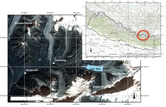
Imja Lake, located in the Khumbu region (27.9◦N, 86.9◦E, Fig. 1), is bounded on the east by the Lhotse-Shar and Imja glaciers, on the north and south by lateral moraines, and to the west by a 700 m wide by 700 m long ice-cored outlet complex (Watanabe
5
et al., 2009; Somos-Valenzuela et al., 2013). The lake, which did not exist in 1960, has experienced rapid growth in area and volume since then; by 2002 it had a volume of 35.8±0.7 million m3 (Sakai et al., 2007), and by 2012 the volume had increased to 61.7±3.7 million m3(Somos-Valenzuela et al., 2014). The western, down-valley ex-pansion has stabilized in recent years while the eastern exex-pansion continues unabated
10
(Watanabe et al., 2009) mostly through calving from the glacier terminus. Avalanche debris falling from surrounding high mountains and hanging ice is prevented from en-tering the lake by the high lateral moraines, which are separated from the surrounding mountains by several 10 s of meters (Hambrey et al., 2008). The bottom of the lake has continued to lower as the ice of the glacier beneath the lake melts (Watanabe et al.,
15
1995; Fujita et al., 2009; Somos-Valenzuela et al., 2014).
The characterization of the risk of Imja Lake is somewhat controversial, with some re-searchers declaring it to be relatively dangerous (Hammond, 1988; Kattelmann, 2003; Ives et al., 2010), and others concluding that it may be stable (Fujita et al., 2009; Watanabe et al., 2009; ICIMOD, 2011). ICIMOD (2011) identified Imja Lake as one of
20
six high-priority glacial lakes in Nepal that require detailed investigation, while other studies have stated that Imja Lake is safe (Fujita et al., 2013) or very low risk (Hambrey et al., 2008). These conflicting classifications are confusing and can be misleading to the general public and communities downstream, who are the stakeholders these stud-ies are meant to assist. Imja Lake is among six glacial lakes identified in the Nepal
Na-25
HESSD
11, 13019–13053, 2014A potential GLOF from Imja Lake in
Nepal
M. A. Somos-Valenzuela et al.
Title Page
Abstract Introduction
Conclusions References
Tables Figures
◭ ◮
◭ ◮
Back Close
Full Screen / Esc
Printer-friendly Version Interactive Discussion
Discussion
P
a
per
|
Discussion
P
a
per
|
Discussion
P
a
per
|
Discussion
P
a
per
|
According to the UNDP project strategy (UNDP, 2013), the “GLOF risks arising from Imja Lake will be significantly reduced by reducing the lake volume through an artificial controlled drainage system combined with a community-based early warning system.” They recommend lowering the lake level by at least 3 m to achieve this risk reduction.
Dingboche is probably the most risk prone area from a potential Imja GLOF. The
5
villages of Chukkung (∼4 km) and Dingboche (∼8 km) are the two nearest settlements from the lake. The former is located relatively off the Imja Khola (stream), so at less risk, whereas the latter is the largest settlement along the stream and it has extensive agricultural lands and buildings within 10–20 m elevation from the stream that will be flooded in the event of a GLOF unless flood prevention measures are taken.
10
In this paper we present a new, two-dimensional debris flow model for predicting the potential GLOF hazard from Imja Lake in terms of inundation depth in downstream communities and present a measure of uncertainty in the GLOF inundation predictions. We analyze four scenarios: current lake conditions, and three risk mitigation scenarios with the lake water level lowered 3, 10 or 20 m below the current level. Finally, we
dis-15
cuss possible methods for lowering the lake water level to reduce the GLOF hazard. To the authors’ knowledge, this is the first attempt to quantify the impact that various flood control alternatives would have on potential GLOF damage in downstream villages.
2 Methodology
2.1 Data
20
To model the propagation of a GLOF from Imja Lake to the downstream community of Dingboche, we used two Digital Elevation Models (DEMs) for the Imja Lake GLOF model: (1) a 5 m×5 m grid cell DEM of the Imja-Lhotse Shar glacier and the moraine surrounding the lake generated from 2006 ALOS imagery (Lamsal et al., 2011); and (2) a DEM extending from the lake to just below Dingboche derived using the method of
25
HESSD
11, 13019–13053, 2014A potential GLOF from Imja Lake in
Nepal
M. A. Somos-Valenzuela et al.
Title Page
Abstract Introduction
Conclusions References
Tables Figures
◭ ◮
◭ ◮
Back Close
Full Screen / Esc
Printer-friendly Version Interactive Discussion
Discussion
P
a
per
|
Discussion
P
a
per
|
Discussion
P
a
per
|
Discussion
P
a
per
|
for flooding and inundation modeling; however, they cover only 11 km of the river basin downstream from the lake. Expanded 5 m×5 m DEM coverage downstream of Ding-boche could be produced, but ALOS imagery was not available for this work. Instead, we used a lower resolution DEM for the region downstream of Dingboche to just below the village of Phakding. Initially a 30 m×30 m resolution DEM was produced from
Ad-5
vanced Space borne Thermal Emission and Reflection Radiometer (ASTER L1) data (Tachikawa, 2011). However, ASTER L1 data has too many unrealistic features such as many ponds between Imja Lake and Phakding that don’t exist according to our field observations. Therefore, we decided to use the DEM created from 40 m interval con-tour topographic maps produced by B. Bajracharya et al. (2007). The modeled portion
10
of the river has a length of 38.5 km from the lake outlet to a point 5 km downstream of the village of Phakding.
Roughness coefficients for eight categories of land cover in the basin were assigned using land cover maps derived from 2006 ASTER imagery for the Sagarmatha Na-tional park (Bajracharya and Uddin, 2010). These values agreed well with those that
15
Cenderelli and Wohl (2001) calculated for the Imja Khola (0.15 and 0.30 for the riverbed and floodplain, respectively), and values that the Flo-2D manual (Flo-2D, 2012) recom-mends for the types of land cover found in the basin.
Somos-Valenzuela et al. (2014) conducted a bathymetric survey of Imja Lake in 2012 and estimated the lake volume was 61.7±3.7 million m3 and 34.1±1.08 million m3 of
20
water could drain from the lake was if the lake surface elevation decreases 35 m from 5010 to 4975 m (the elevation of the valley floor below the lake). For the Imja Lake GLOF model, the lake bathymetry was combined with the DEM of the surrounding moraines and the glacier and used as input to the moraine dam breach model de-scribed below.
25
2.2 Moraine Dam Breach model
HESSD
11, 13019–13053, 2014A potential GLOF from Imja Lake in
Nepal
M. A. Somos-Valenzuela et al.
Title Page
Abstract Introduction
Conclusions References
Tables Figures
◭ ◮
◭ ◮
Back Close
Full Screen / Esc
Printer-friendly Version Interactive Discussion
Discussion
P
a
per
|
Discussion
P
a
per
|
Discussion
P
a
per
|
Discussion
P
a
per
|
piping through the dam and earthquakes (Kattelmann and Watanabe, 1998; Somos-Valenzuela et al., 2013). Other factors that may trigger a GLOF from Imja Lake include hydrostatic pressure or seismic effects causing a failure of the moraine dam. Hydro-static pressure on the moraine may cause intense filtration and piping with potentially catastrophic consequences.
5
We observed seepage from the base of the southern portion of the damming moraine during five visits to the lake between 2011 and 2014. In September 2013 the seepage was measured using a tape measure and portable velocity meter (Global Water flow probe FP111 turbo prop positive displacement sensor with a range of 0.1–6.1 m s−1 and an accuracy of 0.03048 m s−1). At the seepage outlet, 2 sets of measurements
10
were taken and an average flow of 0.005 m3s−1was calculated. In addition, 3 sets of flow measurements were made at the Imja Lake outlet (bridge over the Imja Khola) and an average flow of 2.2 m3s−1was calculated.
To model a potential moraine breach initiating a GLOF from Imja Lake, we use a com-bination of moraine breach analysis tools. First, the shape, final size, and failure time
15
of the breach are estimated from empirical equations. Failure time is the time needed for complete development of the breach from the initial breakthrough to the end of lat-eral enlargement (Froehlich, 2008). Second, these parameters are used in a HEC-RAS dam breach model (USACE, 2010) to simulate the breach hydrograph, which is then used as input to a 2-D downstream inundation model.
20
HESSD
11, 13019–13053, 2014A potential GLOF from Imja Lake in
Nepal
M. A. Somos-Valenzuela et al.
Title Page
Abstract Introduction
Conclusions References
Tables Figures
◭ ◮
◭ ◮
Back Close
Full Screen / Esc
Printer-friendly Version Interactive Discussion
Discussion
P
a
per
|
Discussion
P
a
per
|
Discussion
P
a
per
|
Discussion
P
a
per
|
(Qp, m 3
s−1) are
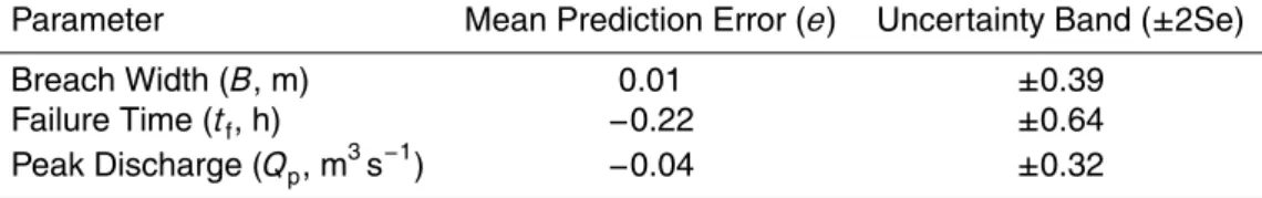
B=0.1803kVw0.32h0.19b (1) tf=0.00254Vw0.53h−0.9b (2) Qp=0.607Vw0.295h1.24w (3)
where the moraine parameters in these equations are the breach height (hb, m), the 5
drainable water volume (Vw, m 3
), the depth of water above the breach invert at the time of failure (hw, m), and overtopping multiplierk (k=1 for no overtopping, and k=1.4
for overtopping). The values of these parameters are shown in Table 1. The value ofVw in Table 1 was taken from the bathymetric survey results of Somos-Valenzuela
et al. (2014). From a large database of dam breach cases, Wahl (2004) derived
equa-10
tions to calculate upper (Pu) and lower (Pl) bounds for the breach parameters
{Pl,Pu}=
n
Pp×10−e−2Se,Pp×10−e+2Se
o
(4)
where Pp is the predicted breach parameter value (B, tf, or Qp) estimated by
Eqs. (1)–(3),eand 2Se are the mean prediction error and the uncertainty band (Wahl, 2004) (see Table 2).
15
Froehlich’s equations provide estimates of the breaching parameters, but to simulate the downstream inundation, the full hydrograph of the breaching event is needed. To obtain full breach hydrographs (lower, predicted and upper) we use the HEC-RAS dam break model (USACE, 2010) with the breach width (B) and failure time (tf) calculated
from Eqs. (1) and (2). These hydrographs were adjusted to match the peak discharge
20
(Qp) values estimated from Eq. (3).
2.3 Inundation model
HESSD
11, 13019–13053, 2014A potential GLOF from Imja Lake in
Nepal
M. A. Somos-Valenzuela et al.
Title Page
Abstract Introduction
Conclusions References
Tables Figures
◭ ◮
◭ ◮
Back Close
Full Screen / Esc
Printer-friendly Version Interactive Discussion
Discussion
P
a
per
|
Discussion
P
a
per
|
Discussion
P
a
per
|
Discussion
P
a
per
|
is suitable to simulate the propagation of the debris flow (Flo-2D, 2012), since the effects of sediments and debris have been shown to be very important factors in GLOF events (Osti and Egashira, 2009). Although the geometry of the grid within Flo-2D is two dimensional, the flow is modeled in eight directions and the model solves the one-dimensional Saint Venant equation independently in each direction. The continuity
5
and momentum equations are solved with a central, finite difference method using an explicit time-stepping scheme. The total friction slope can be expressed as (Flo-2D, 2012; Julien, 2010; O’Brien et al., 1993)
Sf=Sy+Sv+Std=
τy
γmh
+ K ηω
8γmh2 +n
2
V2
h4/3 (5)
whereSyis the yield slope,Svis the viscous slope,Stdis the turbulent-dispersive slope, 10
τyis the Mohr-Coulomb yield stress,γmis the specific weight of the sediment mixture,K
is a resistance parameter,ηis the Bingham dynamic viscosity,V is the depth-averaged velocity,nis the Manning roughness coefficient. Rheological properties,ηandτγ, are
formulated as exponential functions of the sediment volume concentration cv (Julien
and Leon, 2000; Julien, 2010)
15
η=α2eβ2cv (6)
τγ=α1eβ1cv (7)
whereαi and βi are empirical coefficients defined by laboratory experiment (Flo-2D, 2009). Since we have very limited geological information for the study area, the values recommended by the Flo-2D manual forαi and βi are used (α1=0.0765,β1=16.9, 20
α2=0.0648 and β2=6.2). Rickenmann (1999) and Julien and Leon (2000)
HESSD
11, 13019–13053, 2014A potential GLOF from Imja Lake in
Nepal
M. A. Somos-Valenzuela et al.
Title Page
Abstract Introduction
Conclusions References
Tables Figures
◭ ◮
◭ ◮
Back Close
Full Screen / Esc
Printer-friendly Version Interactive Discussion
Discussion
P
a
per
|
Discussion
P
a
per
|
Discussion
P
a
per
|
Discussion
P
a
per
|
3 Results
The Imja GLOF model described above was used to model four scenarios of a GLOF occurring from Imja Lake: current lake conditions with the water surface at 5010 m, and three flood mitigation scenarios with the lake water level lowered 3, 10 and 20 m, respectively. The flood mitigation scenarios represent possible lake lowering efforts
5
starting with the current UNDP project to lower the lake at least 3 m. In case that sce-nario does not provide any significant flood reduction downstream at Dingboche, the other scenarios can provide some guidance as to how much farther the lake might need to be lowered to achieve reduced risk. It is important to note that no other studies have analyzed the potential benefits of lowering Imja Lake and that the selection of
10
a preferred lake lowering alternative needs to be based on such an analysis as that presented here.
3.1 Moraine breaching model
3.1.1 Breach parameters
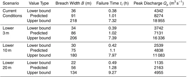
Table 3 shows the results of using Eqs. (1)–(3) and the moraine characteristics in
Ta-15
ble 1 to calculate the lower bound, predicted, and upper bound values of the breaching parameters (B,tf, andQp). The upper and lower bounds of the breaching parameters
were calculated from Eqs. (4) and (5) using the prediction errors and uncertainty bands from Table 2. Lowering the lake level by 3 m does not result in a significant change in the failure time and only a 13.8 % decrease in the peak discharge. However, lowering
20
the level by 10 m has a major impact on peak discharge, reducing it by 58.5 % and further lowering of the level to 20 m reduces the discharge by 73.8 %.
3.1.2 Breach hydrographs
Discharge hydrographs for potential moraine breaches at Imja Lake were computed us-ing the HEC-RAS dam break module and the lower bound, predicted, and upper bound
HESSD
11, 13019–13053, 2014A potential GLOF from Imja Lake in
Nepal
M. A. Somos-Valenzuela et al.
Title Page
Abstract Introduction
Conclusions References
Tables Figures
◭ ◮
◭ ◮
Back Close
Full Screen / Esc
Printer-friendly Version Interactive Discussion
Discussion
P
a
per
|
Discussion
P
a
per
|
Discussion
P
a
per
|
Discussion
P
a
per
|
breach parameters under the current conditions scenario (see Table 4). The HEC-RAS hydrograph peak discharges were matched to the peak discharge values in Table 3 by adjusting the failure time within the range shown in the table. The predicted peak discharge is 8394 m3s−1(see Table 4 – Imja Lake) compared to 8274 m3s−1computed with Froehlich’s equation, a difference of 1.4 %. The range of peak discharge (upper
mi-5
nus lower bound) is 14 728 m3s−1compared to 14 613 m3s−1computed by Froehlich’s equation, about 0.8 % difference. These results indicate good agreement between the HEC-RAS computed hydrograph values and the empirical Froehlich equation values.
3.2 Inundation model
The Flo-2D inundation model was used to compute the results of the 4 potential Imja
10
Lake GLOF scenarios. The first scenario considers the lake in its current condition with the lake level at 5010 m above mean sea level. Then alternatives with lake levels 3, 10, and 20 m lower than this were considered.
3.2.1 Current conditions scenario
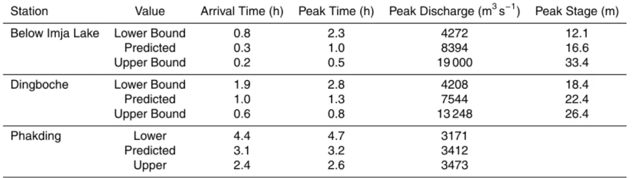
The results (lower bound, expected value, upper bound) of modeling a potential GLOF
15
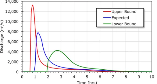
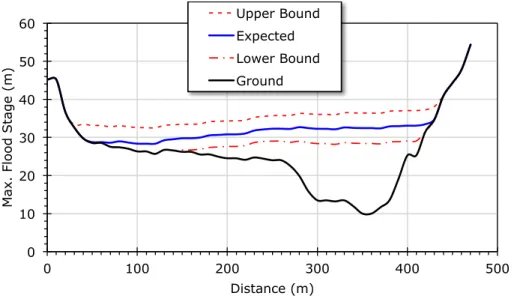
from Imja Lake under current conditions are shown in Table 4 and Figs. 2–4 at Ding-boche (at the cross section indicated in Fig. 4). Table 4 also shows the flood arrival time, peak time, peak stage, and flood peak discharge just downstream of Imja Lake and at Dingboche. Figure 2 shows the expected GLOF discharge hydrograph and bounds at Dingboche. The flood arrives at Dingboche 1 h after the breaching begins (range
20
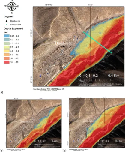
0.6–1.9 h), peaks at 1.3 h (range 0.8–2.8 h) and is over after about 7 h. Figure 3 shows the flood stage at Dingboche (upper bound, expected value, lower bound). The highest expected flood stage is 22.4 m (range 18.4–26.4 m) and the peak flow is 7544 m3s−1 (range 4208–13 248 m3s−1). Figure 4a shows the expected inundation at Dingboche. The lower and upper bounds are also shown in Fig. 4b and c, respectively.
HESSD
11, 13019–13053, 2014A potential GLOF from Imja Lake in
Nepal
M. A. Somos-Valenzuela et al.
Title Page
Abstract Introduction
Conclusions References
Tables Figures
◭ ◮
◭ ◮
Back Close
Full Screen / Esc
Printer-friendly Version Interactive Discussion
Discussion
P
a
per
|
Discussion
P
a
per
|
Discussion
P
a
per
|
Discussion
P
a
per
|
The inundated area at Dingboche was mapped in GIS and shows that, under the expected value simulation, most of the inundation is in the farming terrace areas and not the main lodges and other infrastructure along the primary trekking trail through the village (see Fig. 4, top image). With no lake lowering, about 9.4 ha of farmland will be inundated and 29 structures impacted (see Table 5, 0 m lowering scenario).
5
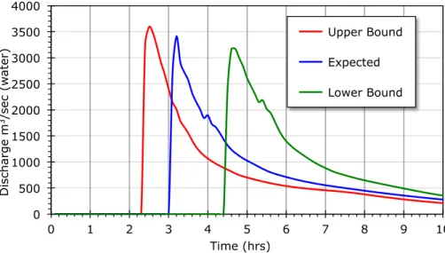
Further downstream at Phakding, the flooding also has an impact on potential flood-ing. At Phakding, the flood arrives 3.1 h (range 2.4–4.4 h) after the breaching begins and peaks at 3.2 h (range 2.6–4.7 h) with a peak discharge of 3412 m3s−1 (range 3171–3473 m3s−1) (see Fig. 5). The lag time between the peak flow at Imja Lake and the peak at Phakding is 2.2 h (see Table 4).
10
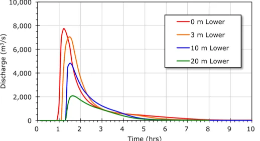
3.2.2 Lake lowering scenarios
A proposal to reduce the risk of a GLOF from Imja Lake that is currently (2014) under implementation is to lower the water level of the lake at least 3 m (UNDP, 2013). The Imja GLOF model was used to assess the potential flood reduction at Dingboche if such a plan were to be implemented. To this end, the model was run with lake levels
15
3, 10, and 20 m lower than the current conditions scenario level (5010 m). The results for these scenarios are shown in Table 5 and Figs. 6–8. Figures 6 and 7 show the hydrographs and flood stage, respectively, at Dingboche for the 0, 3, 10 and 20 m lake lowering scenarios. Figure 8 maps the inundation depth at Dingboche for the different lake lowering scenarios. Lowering the lake 3 m (Fig. 8a) results in a 2.7 % reduction
20
in the peak flood depth at Dingboche (compared to the 0 m lowering scenario) with the peak flood height lowering 0.6 m (from 22.4 to 21.8 m). This flood height still leads to significant inundation of homes and farmlands. With the lake lowered by 3 m about 8.6 ha of farmland and 25 structures are impacted by the flooding. In contrast, lowering the lake 10 m (Fig. 8b) or 20 m (Fig. 8c) results in a 14 and 36 % flood height
reduc-25
HESSD
11, 13019–13053, 2014A potential GLOF from Imja Lake in
Nepal
M. A. Somos-Valenzuela et al.
Title Page
Abstract Introduction
Conclusions References
Tables Figures
◭ ◮
◭ ◮
Back Close
Full Screen / Esc
Printer-friendly Version Interactive Discussion
Discussion
P
a
per
|
Discussion
P
a
per
|
Discussion
P
a
per
|
Discussion
P
a
per
|
inundates little farmland and floods no structures. When the lake is lowered 10 m about 4 ha of farmland will be inundated and 18 structures impacted and at 20 m lowering about 1 ha of farmland will be inundated and 0 structures impacted. Additionally, the peak discharge is reduced by 6.5, 40.6 and 73.8 % as a result of lowering the lake by 3, 10 or 20 m, respectively (Table 5).
5
Further downstream at Phakding, the lake lowering scenarios have an impact on po-tential flooding as well (see Fig. 9). Lowering the lake 3 m results in a 13.9 % reduction of peak flow at Phakding. In contrast, lowering the lake 10 m results in 49.3 % reduc-tion at Phakding, and lowering 20 m results in an 81.6 % reducreduc-tion at Phakding (see Table 5).
10
4 Discussion
4.1 Comparison to previous Imja Lake GLOF modeling
B. Bajracharya et al. (2007) developed a water-flow GLOF model for Imja Lake that simulated flood flow in the Imja Khola and Dudh Kosi from the lake to about 45 km downstream of the outlet near Phakding. That one-dimensional model used a DEM
15
derived from satellite data (30 m×30 m grid cells) and one interpolated from 40 m con-tour maps (5 m×5 m grid cells). This is the same DEM that we used for the reach from Dingboche to Phakding. The bathymetry of Imja Lake was taken from a 2002 survey indicating the total volume of the lake was 35.8±0.7 million m3 (Sakai et al., 2007), rather than the 61.7±3.7 million m3total volume used in this study based on the
20
more recent 2012 survey (Somos-Valenzuela et al., 2014). The US National Weather Service (NWS) BREACH model (Fread, 1988) was used to generate moraine breach hydrographs that were passed to a NWS FLDWAV model (Fread and Lewis, 1998) and routed downstream. Peak flows at the cross-sections of the FLDWAV model were in-put to a steady-state US Army Corps of Engineers HEC-RAS model (USACE, 2010)
25
HESSD
11, 13019–13053, 2014A potential GLOF from Imja Lake in
Nepal
M. A. Somos-Valenzuela et al.
Title Page
Abstract Introduction
Conclusions References
Tables Figures
◭ ◮
◭ ◮
Back Close
Full Screen / Esc
Printer-friendly Version Interactive Discussion
Discussion
P
a
per
|
Discussion
P
a
per
|
Discussion
P
a
per
|
Discussion
P
a
per
|
B. Bajracharya et al. (2007) using additional field results to more accurately define the geotechnical parameters of the moraine. The lake bathymetry was updated from 2009 fieldwork with the total volume reported to be 35.5 million m3(ICIMOD, 2011). The moraine-breaching trigger was not specified and might be either overtopping or piping. The simulated breach depth was 30 m, the same as we used here.
5
We can compare the results of ICIMOD (2011) with those reported here, since this is being asked of the consultants working on the UNDP Imja Lake risk reduction project (UNDP, 2013). For the breaching process, ICIMOD reported a breaching time of 2.9 h with a peak discharge of 5817 m3s−1; whereas, we calculate 1.01 h (range 0.38 to 7.32 h) and a peak of 8394 m3s−1 (range 4272 to 19 000 m3s−1). At Dingboche,
10
ICIMOD reported a flood arrival of 3.1 h with a peak of 3000 m3s−1 (estimated from Fig. 8.2, p. 65); whereas, we show flood arrival at 1 h (range 0.6–1.9 h) and a peak of 7544 m3s−1(range 4208–13 248 m3s−1). At Ghat near Phakding, ICIMOD reported ar-rival at 4.2 h with a peak of 2300 m3s−1, whereas, we calculate 3.1 h (range 2.4–4.4 h) with a peak of 3412 m3s−1 (range 3171–3473 m3s−1). The reason for the differences
15
here is most likely the use of the significantly smaller Imja Lake volume in the ICIMOD calculations due to the bathymetry used. This causes faster propagation of larger flows downstream. In assessing the possibly reduced risk to downstream communities from implementing a lake lowering alternative, it is recommended that the latest estimates of the volume and bathymetry of Imja Lake be used, e.g., 2012 or later.
20
4.2 Options for Imja Lake risk reduction
To date there is no agreed upon set of hazard indicators for Imja Lake, or other poten-tially dangerous glacial lakes for that matter (Somos-Valenzuela et al., 2013); however, the definition of GLOF hazard from Imja Lake was discussed in consultations with com-munity members in Dingboche in September 2012 and subsequently. The hazard of an
25
HESSD
11, 13019–13053, 2014A potential GLOF from Imja Lake in
Nepal
M. A. Somos-Valenzuela et al.
Title Page
Abstract Introduction
Conclusions References
Tables Figures
◭ ◮
◭ ◮
Back Close
Full Screen / Esc
Printer-friendly Version Interactive Discussion
Discussion
P
a
per
|
Discussion
P
a
per
|
Discussion
P
a
per
|
Discussion
P
a
per
|
them, hazard is having their farms or homes flooded or washed away, a prospect that they want reduced and preferably eliminated (Somos-Valenzuela et al., 2013).
The feasibility of possible remedial actions at Imja Lake to reduce the hazard to downstream communities was evaluated. One scenario that appears to have significant risk reduction possibility is lowering the lake 20 m. Of course, there are other impacts
5
of a GLOF from Imja Lake that will be felt downstream, in particular there are several stretches of the main trekking trail from Namche Bazar to Lukla that run quite close to the river and would be washed away, as they were in the 1985 Dig Tsho GLOF (Ives, 1986; Vuichard and Zimmermann, 1986). In addition some parts of villages along the trail have fields and houses near the river, and they may also be impacted. However,
10
providing reduced flooding at Dingboche should also provide protection to many of the downstream areas as well. Lowering the lake by any amount will reduce the probability of GLOF occurrence for at least two reasons, the hydrostatic pressure on the moraine would be reduced and the top of the moraine would be wider and more difficult to breach. Consequently, reducing the GLOF’s occurrence probability would decrease
15
the hazard level downstream.
Of the methods to reduce glacial lake risk, e.g., relocation of people and assets from the flood path, strengthening the lake outlet (Kattelmann and Watanabe, 1998), the one that has been employed the most is lowering the lake level. This has been used at nearly 40 dangerous glacial lakes in Peru since the 1950s (Portocarrero, 2014).
20
Typically, the lake is lowered to a safe level by siphoning or draining and then excavat-ing the dammexcavat-ing moraine and installexcavat-ing a drainage channel at the desired elevation. Often, a reinforced earthen dam is then constructed to replace the original unconsoli-dated moraine dam, such that if a surge wave overtops the dam it will contain much of the excess water and not fail from erosion (Somos-Valenzuela et al., 2013). In order to
25
HESSD
11, 13019–13053, 2014A potential GLOF from Imja Lake in
Nepal
M. A. Somos-Valenzuela et al.
Title Page
Abstract Introduction
Conclusions References
Tables Figures
◭ ◮
◭ ◮
Back Close
Full Screen / Esc
Printer-friendly Version Interactive Discussion
Discussion
P
a
per
|
Discussion
P
a
per
|
Discussion
P
a
per
|
Discussion
P
a
per
|
The UNDP Imja Lake project suggests that lowering the lake “at least” 3 m will achieve significant risk reduction downstream (UNDP 2013), but there is no require-ment to estimate the remaining risk when the lake is lowered to different levels (3, 10, 20 m). This work has attempted analyze this question. Siphons may be used at Imja Lake to progressively lower the level in 3–5 m increments followed by excavation of the
5
lake outlet.
Previous studies have suggested deepening and strengthening the outlet of Imja Lake (Maskey, 2012). However, there are many difficulties in implementing this method. First, the natural flow of the outlet must be interrupted somehow in order to perform any excavation of the channel. In the siphoning method discussed above, the lake is
low-10
ered and then the outlet can be excavated to that level without needing to divert the outlet flow. One method that has been proposed is to build a coffer dam and divert water to flow over another part of the damming moraine and then excavate the ex-isting outlet channel of the lake to increase its depth and discharge (Maskey, 2012). The difficulties of employing this method include: (1) possibly encountering ice
dur-15
ing the excavation, significantly weakening the moraine and possibly inducing a GLOF, (2) diversion of the outlet flow might cause excessive erosion that could weaken the moraine and potentially lead to a GLOF, and (3) the existence of small ponds in the outlet complex that are separated with shallow necks (with as little as 1.5 m depth) through which the lake water flows might prevent the draining of the lake unless they
20
were also excavated (Somos-Valenzuela et al., 2013). The difficulty of encountering buried ice exists in any method employing excavation of the damming moraine and the moraine must be examined in detail with geophysical methods before this can be done safely. The example of Tsho Rolpa is being used as a model lake lowering sys-tem for Imja Lake (UNDP, 2013). An outlet channel was constructed at Tsho Rolpa and
25
HESSD
11, 13019–13053, 2014A potential GLOF from Imja Lake in
Nepal
M. A. Somos-Valenzuela et al.
Title Page
Abstract Introduction
Conclusions References
Tables Figures
◭ ◮
◭ ◮
Back Close
Full Screen / Esc
Printer-friendly Version Interactive Discussion
Discussion
P
a
per
|
Discussion
P
a
per
|
Discussion
P
a
per
|
Discussion
P
a
per
|
probably 20 m to achieve significant hazard reduction. Lowering Imja Lake will require draining: (1) the normal inflow to the lake, (2) the volume of the lake expansion during the time of drainage, and (3) the volume of the lake necessary to achieve 3 m lowering per drainage cycle (Somos-Valenzuela et al., 2013). Lake discharge was measured in May 2012 by a group from Kathmandu University using a tracer dilution method
5
(Maskey, 2012) and by the authors using a timed float method (Somos-Valenzuela et al., 2013). In both cases the flow was found to be approximately 1 m3s−1.
The authors again measured the flow with a flow meter in September 2013 and found the discharge to be approximately 2 m3s−1 (see above for description of method). The lake area was 1.257±0.104 km2 in September 2012, and increasing
10
by about 0.04 km2yr−1(Somos-Valenzuela et al., 2014). This will require 1.353 m3s−1 of drainage to lower the lake 3 m during a 5 month period in the melt season using 13 siphon pipes of 350 mm diameter.
5 Conclusions
Methods for reducing the downstream inundation hazard from a GLOF originating at
15
Imja Lake in Nepal were explored. A 2-dimensional debris flow model was developed to assess the downstream inundation. Inundation reducing scenarios were analyzed and an alternative under design, lowering the lake at least 3 m, was found not to have significant flood reduction benefits. The results indicate that the lake needs to be low-ered about 20 m in order to completely reduce the impacts that a GLOF could have at
20
Dingboche and further downstream. The results show that a GLOF occurring under the current lake conditions would result in inundation of much of the farming areas (about 9.4 ha and 29 structures impacted) at Dingboche but not the main lodges and other in-frastructure along the primary trekking trail through the village. Lowering lake 3 m does not change this result much, but 10 m lowering reduces the impact substantially with
25
HESSD
11, 13019–13053, 2014A potential GLOF from Imja Lake in
Nepal
M. A. Somos-Valenzuela et al.
Title Page
Abstract Introduction
Conclusions References
Tables Figures
◭ ◮
◭ ◮
Back Close
Full Screen / Esc
Printer-friendly Version Interactive Discussion
Discussion
P
a
per
|
Discussion
P
a
per
|
Discussion
P
a
per
|
Discussion
P
a
per
|
a coordinated sequence of siphoning to lower the water level in 3 m increments, fol-lowed by outlet excavation to maintain the new level. The process would be repeated as needed to reach the desired lake level.
Acknowledgements. The authors acknowledge the support of the USAID Climate Change Re-silient Development (CCRD) project and the Fulbright Foundation for the support of
Somos-5
Valenzuela. The support of the software developers of Flo-2D made much of the work reported here possible.
References
Bajracharya, B. and Uddin, K.: Study of Land Cover Dynamics in Sagarmatha National Park and Buffer Zone, 10th Int. Symp. High Mt. Remote Sens. Cartogr., Kathmandu, Nepal, 12–19
10
September 2008, 125–132, 2010.
Bajracharya, B., Shrestha, A. B., and Rajbhandari, L.: Glacial lake outburst floods in the Sagart-matha regions: hazard assessment using GIS and hydrological modeling, Mt. Res. Dev., 27, 336–344, 2007.
Bajracharya, S. R., Mool, P. K., and Shrestha, B. R.: Impact of Climate Change on Himalayan
15
Glaciers and Glacial Lakes Case Studies on GLOF and Associated Hazards in Nepal and Bhutan, International Centre for Integrated Mountain Development (ICIMOD), Kathmandu, 2007.
Bolch, T., Buchroithner, M. F., Peters, J., Baessler, M., and Bajracharya, S.: Identification of glacier motion and potentially dangerous glacial lakes in the Mt. Everest region/Nepal using
20
spaceborne imagery, Nat. Hazards Earth Syst. Sci., 8, 1329–1340, doi:10.5194/nhess-8-1329-2008, 2008.
Buchroithner, M. F., Jentsch, G., and Wanivenhaus, B.: Monitoring of recent geoligical events in the Khumbu Area (Himalaya, Nepal) by Digital Processing of Landsat MSS Data, Rock Mech., 15, 181–197, 1982.
25
HESSD
11, 13019–13053, 2014A potential GLOF from Imja Lake in
Nepal
M. A. Somos-Valenzuela et al.
Title Page
Abstract Introduction
Conclusions References
Tables Figures
◭ ◮
◭ ◮
Back Close
Full Screen / Esc
Printer-friendly Version Interactive Discussion
Discussion
P
a
per
|
Discussion
P
a
per
|
Discussion
P
a
per
|
Discussion
P
a
per
|
Froehlich, D. C.: Embankment dam breach parameters revisited, in: Proc., 1st Int. Conf. on Water Resources Engineering, American Society of Civil Engineers, New York, 14–18 August 1995, 887–891, 1995.
Froehlich, D. C.: Embankment dam breaches and their uncertainties, J. Water Res. Pl.-ASCE, 121, 90–97, 2008.
5
Fread, D. L.: BREACH, an Erosion Model for Earthen Dam Failures, United States National Weather Service, Hydrologic Research Laboratory, Silver Spring, Maryland, 58 pp., 1988. Fread, D. L. and Lewis, J. M.: NWS FLDWAV Model, Theoretical Development, User Document,
Silver Spring, MD, 1998.
Fujita, K., Sakai, A., Nuimura, T., Yamaguchi, S., and Sharma, R. R.: Recent changes in
10
Imja Lake and its damming moraine in the Nepal Himalaya revealed by in-situ surveys and multi-temporal ASTER imagery, Environ. Res. Lett., 4, 045205, doi:10.1088/1748-9326/4/4/045205, 2009.
Fujita, K., Sakai, A., Takenaka, S., Nuimura, T., Surazakov, A. B., Sawagaki, T., and Ya-manokuchi, T.: Potential flood volume of Himalayan glacial lakes, Nat. Hazards Earth Syst.
15
Sci., 13, 1827–1839, doi:10.5194/nhess-13-1827-2013, 2013.
Grabs, W. E. and Hanisch, J.: Objectives and prevention methods for Glacier Lake Outburst Floods (GLOFs), snow and glacier hydrology, Proc. Of the Kathmandu Symposium, Novem-ber, Kathmandu, Nepal, IAHS Publ. no. 218, 1993.
Hambrey, M. J., Quincey, D. J., Glasser, N. F., Reynolds, J. M., Richardson, S. J.,
20
and Clemmens, S.: Sedimentological, geomorphological and dynamic context of debris-mantled glaciers, Mountain Everest (Sagarmatha) region, Nepal, Quaternary Sci. Rev., 27, 2361–2389, 2008.
Hammond, J. E.: Glacial lakes in the Khumbu region, Nepal: an assessment of the hazards, unpublished, M.A. thesis, University of Colorado, Boulder, CO, 1988.
25
ICIMOD-International Centre for Integrated Mountain Development: Glacial lakes and glacial lake outburst floods in Nepal, International Centre for Integrated Mountain Development (ICI-MOD), Kathmandu, Nepal, 2011.
Ives, J.: Glacial Lake Outburst Floods and Risk Engineering in the Himalaya, International Cen-tre for Integrated Mountain Development (ICIMOD), Occasional Paper No. 5, Kathmandu,
30
HESSD
11, 13019–13053, 2014A potential GLOF from Imja Lake in
Nepal
M. A. Somos-Valenzuela et al.
Title Page
Abstract Introduction
Conclusions References
Tables Figures
◭ ◮
◭ ◮
Back Close
Full Screen / Esc
Printer-friendly Version Interactive Discussion
Discussion
P
a
per
|
Discussion
P
a
per
|
Discussion
P
a
per
|
Discussion
P
a
per
|
Ives, J. D., Shrestha, R. B., and Mool, P. K.: Formation of glacial lakes in the Hindu Kush-Himalayas and GLOF risk assessment, International Centre for Integrated Mountain Devel-opment (ICIMOD), Kathmandu, Nepal, 2010.
Julien, P. Y.: Erosion and Sedimentation, 2nd edn., Cambridge University Press, Cambridge, UK, 2010.
5
Julien, P. Y. and Leon, C. A.: Mud floods, mudlows and debris flows classification, rheology and structural design, in: Int. Work. Mudflows Debris Flows, Caracas, Venezuela, 1–16, 27 November–1 December 2000.
Kattelmann, R.: Glacial lake outburst floods in the Nepal Himalaya: a manageable hazard?, Nat. Hazards, 28, 145–154, 2003.
10
Kattelmann, R. and Watanabe, T.: Approaches to reducing the hazard of an outburst flood of Imja Glacier Lake, Khumbu Himal, in: Proc. of International Conference on Ecohydrology of High Mountain Areas, Kathmandu, Nepal, 24–28 March 1996, 359–366, UNESCO, 1998. Lamsal, D., Sawagaki, T., and Watanabe, T.: Digital terrain modelling using corona and ALOS
PRISM data to investigate the distal part of Imja Glacier, Khumbu Himal, Nepal, J. Mt. Sci.,
15
8, 390–402, 2011.
Maskey, R. K.: Topographic Survey and Engineering Design of the Outlet Channel and Pre-feasibility Study for a Mini-Hydropower Generation Facility from Imja Lake, USAID ADAPT Asia-Pacific Support to UNDP/Nepal: Community Based GLOF and Flood Risk Reduction Project, Bangkok, United States Agency for International Development (USAID), 2012.
20
MoE – Ministry of the Environment: National Adaptation Programme of Action to Climate Change, Kathmandu, Nepal, 2010.
Mool, P. K., Bajracharya, S. R., and Joshi, S. P.: Risk Assessment of Lake Rolpa Glacial Lake along the Rolwaling and Tama Kosi Valleys Dolakha District, Nepal, International Centre for Integrated Mountain Development (ICIMOD), Kathmandu, Nepal, 2001.
25
O’Brien, J. S, Julien, P. Y., and Fullerton, W. T.: Two-dimensional water flood and mudlow sim-ulation, J. Hydraul. Eng., 119, 244–261, 1993.
Osti, R. and Egashira, S.: Hydrodynamic characteristics of the Tam Pokhari Glacial Lake outburst flood in the Mt. Everest region, Nepal, Hydrol. Process., 23, 2943–2955, doi:10.1002/hyp.7405, 2009.
30
HESSD
11, 13019–13053, 2014A potential GLOF from Imja Lake in
Nepal
M. A. Somos-Valenzuela et al.
Title Page
Abstract Introduction
Conclusions References
Tables Figures
◭ ◮
◭ ◮
Back Close
Full Screen / Esc
Printer-friendly Version Interactive Discussion
Discussion
P
a
per
|
Discussion
P
a
per
|
Discussion
P
a
per
|
Discussion
P
a
per
|
Rana, B., Shrestha, A. B., Reynolds, J. M., Aryal, R., Pokhrel, A. P., and Budhathoki, K. P.: Hazard assessment of the Lake Rolpa Glacier Lake and ongoing remediation measures, J. Nepal Geological Society, 22, 563–570, 2000.
Reynolds, J. M., Dolecki, A., and Portocarrero, C.: The construction of a drainage tunnel as part of glacial lake hazard mitigation at Hualcán, Cordillera Blanca, Peru, Geological Society,
5
London, Eng. Geol. Special Publications 1998, London, 15, 41–48, 1998.
Rickenmann, D.: Empirical relationships for debris flows, Nat. Hazards, 19, 47–77, 1999. Sakai, A., Saito, M., Nishimura, K., Yamada, T., Iizuka, Y., Harada, K., Kobayashi, S., Fujita, K.,
and Gurung, C. B.: Topographical survey of end-moraine and dead ice area at the Imja Glacial Lake in 2001 and 2002, Bull. Glaciol. Res., 24, 29–36, 2007.
10
Shrestha, A. B. and Aryal, R.: Climate change in Nepal and its impact on Himalayan glaciers, Reg. Environ. Change, 11, S65–S77, 2011.
Somos-Valenzuela, M., McKinney, D. C., Byers, A. C., Rounce, D. R., and Portocarrero, C.: Modeling mitigation strategies for risk reduction at Imja Lake, Nepal, High Mountain Glacial Watershed Program, CRWR Online Report 13–06, Center for Research in Water Resources,
15
University of Texas, Austin, 2013.
Somos-Valenzuela, M. A., McKinney, D. C., Rounce, D. R., and Byers, A. C.: Changes in Imja Tsho in the Mount Everest region of Nepal, The Cryosphere, 8, 1661–1671, doi:10.5194/tc-8-1661-2014, 2014.
UNDP – United Nations Development Programme: Community based glacier lake outburst and
20
flood risk reduction in Nepal, Project Document, UNDP Environmental Finance Services, Kathmandu, Nepal, 2013.
USACE – U.S. Army Corps of Engineers: HEC-RAS River Analysis System Hydraulic Users Manual (Version 4.1), Hydrological Engineering Center, Davis, CA, 2010.
Vuichard, D. and Zimmermann, M.: The Langmoche flash-flood, Khumbu Himal, Nepal, Mt.
25
Res. Dev., 6, 90–94, 1986.
Wahl, T. L.: Uncertainty of predictions for embankment dam breach parameters, J. Hydraul. Eng., 130, 389–397, 2004.
Wahl, T. L.: Dam Breach Modeling – an Overview Of Analysis Methods, Joint Federal Inter-agency Conference on Sedimentation and Hydrologic Modeling, 27 June–1 July 2010, Las
30
HESSD
11, 13019–13053, 2014A potential GLOF from Imja Lake in
Nepal
M. A. Somos-Valenzuela et al.
Title Page
Abstract Introduction
Conclusions References
Tables Figures
◭ ◮
◭ ◮
Back Close
Full Screen / Esc
Printer-friendly Version Interactive Discussion
Discussion
P
a
per
|
Discussion
P
a
per
|
Discussion
P
a
per
|
Discussion
P
a
per
|
Watanabe, T., Kameyama, S., and Sato, T.: Imja glacier dead-ice melt rates and changes in a supra-glacial lake, 1989–1994, Khumbu Himal, Nepal: danger of lake drainage, Mt. Res. Dev., 15, 293–300, 1995.
Watanabe, T., Lamsal, D., and Ives, J. D.: Evaluating the growth characteristics of a glacial lake and its degree of danger of outburst flooding: Imja glacier, Khumbu Himal, Nepal, Norsk
5
Geogr. Tidsskr., 63, 255–267, 2009.
Westoby, M. J., Glasser, N. F., Brasington, J., Hambrey, M. J., Quincey, D. J., and Reynolds, J. M.: Modelling outburst floods from moraine-dammed glacial lakes, Earth-Sci. Rev., 134, 137–159, doi:10.1016/j.earscirev.2014.03.009, 2014.
WGMS – World Glacier Monitoring Service: Preliminary Glacier Mass Balance Data 2010/2011,
10
HESSD
11, 13019–13053, 2014A potential GLOF from Imja Lake in
Nepal
M. A. Somos-Valenzuela et al.
Title Page
Abstract Introduction
Conclusions References
Tables Figures
◭ ◮
◭ ◮
Back Close
Full Screen / Esc
Printer-friendly Version Interactive Discussion
Discussion
P
a
per
|
Discussion
P
a
per
|
Discussion
P
a
per
|
Discussion
P
a
per
|
Table 1.Moraine parameter values used in the breaching equations.
Parameter Scenario
Current Lake Lowering
Conditions 3 m 10 m 20 m
Moraine height (hd, m) 35 32 25 15
Breach height (hb, m) 35 32 25 15
Water height (hw, m) 35 32 25 15
HESSD
11, 13019–13053, 2014A potential GLOF from Imja Lake in
Nepal
M. A. Somos-Valenzuela et al.
Title Page
Abstract Introduction
Conclusions References
Tables Figures
◭ ◮
◭ ◮
Back Close
Full Screen / Esc
Printer-friendly Version Interactive Discussion
Discussion
P
a
per
|
Discussion
P
a
per
|
Discussion
P
a
per
|
Discussion
P
a
per
|
Table 2.Prediction error and uncertainty bands for the Froehlich breaching equations.
Parameter Mean Prediction Error (e) Uncertainty Band (±2Se)
Breach Width (B, m) 0.01 ±0.39
Failure Time (tf, h) −0.22 ±0.64
HESSD
11, 13019–13053, 2014A potential GLOF from Imja Lake in
Nepal
M. A. Somos-Valenzuela et al.
Title Page
Abstract Introduction
Conclusions References
Tables Figures
◭ ◮
◭ ◮
Back Close
Full Screen / Esc
Printer-friendly Version Interactive Discussion
Discussion
P
a
per
|
Discussion
P
a
per
|
Discussion
P
a
per
|
Discussion
P
a
per
|
Table 3.Breach parameter expected values and uncertainty bands for four scenarios.
Scenario Value Type Breach WidthB(m) Failure Timetf(h) Peak DischargeQp(m 3
s−1)
Current Lower bound 36 0.38 4342
Conditions Predicted 91 1.01 8274
Upper bound 218 7.32 18 955
Lower Lower bound 34 0.39 3742
3 m Predicted 86 1.02 7131
Upper bound 206 7.39 16 336
Lower Lower bound 30 0.42 2539
10 m Predicted 75 1.1 4838
Upper bound 180 7.97 11 083
Lower Lower bound 22 0.49 1135
20 m Predicted 56 1.28 2163
HESSD
11, 13019–13053, 2014A potential GLOF from Imja Lake in
Nepal
M. A. Somos-Valenzuela et al.
Title Page
Abstract Introduction
Conclusions References
Tables Figures
◭ ◮
◭ ◮
Back Close
Full Screen / Esc
Printer-friendly Version Interactive Discussion
Discussion
P
a
per
|
Discussion
P
a
per
|
Discussion
P
a
per
|
Discussion
P
a
per
|
Table 4.Inundation model expected values and uncertainty bands at Imja Lake, Dingboche and Phakding for current lake conditions.
Station Value Arrival Time (h) Peak Time (h) Peak Discharge (m3s−1) Peak Stage (m)
Below Imja Lake Lower Bound 0.8 2.3 4272 12.1
Predicted 0.3 1.0 8394 16.6
Upper Bound 0.2 0.5 19 000 33.4
Dingboche Lower Bound 1.9 2.8 4208 18.4
Predicted 1.0 1.3 7544 22.4
Upper Bound 0.6 0.8 13 248 26.4
Phakding Lower 4.4 4.7 3171
Predicted 3.1 3.2 3412
HESSD
11, 13019–13053, 2014A potential GLOF from Imja Lake in
Nepal
M. A. Somos-Valenzuela et al.
Title Page
Abstract Introduction
Conclusions References
Tables Figures
◭ ◮
◭ ◮
Back Close
Full Screen / Esc
Printer-friendly Version Interactive Discussion
Discussion
P
a
per
|
Discussion
P
a
per
|
Discussion
P
a
per
|
Discussion
P
a
per
|
Table 5.Inundation model results at Dingboche and Phakding for lake lowering scenarios under current conditions.
Lake Lowering Arrival Peak Peak Discharge Peak Discharge Peak Peak Depth Farm Area Buildings
Scenario (m) Time (h) Time (h) (m3s−1) Reduction∗(%) Depth (m) Reduction∗(%) Inundated (m2) Inundated (#) Dingboche
0 1.0 1.3 7544 0 22.4 0 93 650 29
3 1.1 1.5 7053 6.5 21.8 2.7 86 262 25
10 1.3 1.6 4479 40.6 19.2 14.3 40 226 18
20 1.3 1.8 1975 73.8 14.4 35.9 10 686 0
Phakding
0 m 3.1 3.2 3412 0
3 m 3.2 3.5 2937 13.9
10 m 3.9 4.2 1730 49.3
20 m 5.8 6.1 629 81.8
∗
HESSD
11, 13019–13053, 2014A potential GLOF from Imja Lake in
Nepal
M. A. Somos-Valenzuela et al.
Title Page
Abstract Introduction
Conclusions References
Tables Figures
◭ ◮
◭ ◮
Back Close
Full Screen / Esc
Printer-friendly Version Interactive Discussion
Discussion
P
a
per
|
Discussion
P
a
per
|
Discussion
P
a
per
|
Discussion
P
a
per
|
0 2,000 4,000 6,000 8,000 10,000 12,000 14,000
0 1 2 3 4 5 6 7 8 9 10
D
isch
a
rge
(
m
3/s)
Time (hrs)
Upper Bound Expected Lower Bound
HESSD
11, 13019–13053, 2014A potential GLOF from Imja Lake in
Nepal
M. A. Somos-Valenzuela et al.
Title Page
Abstract Introduction
Conclusions References
Tables Figures
◭ ◮
◭ ◮
Back Close
Full Screen / Esc
Printer-friendly Version Interactive Discussion
Discussion
P
a
per
|
Discussion
P
a
per
|
Discussion
P
a
per
|
Discussion
P
a
per
|
0 10 20 30 40 50 60
0 100 200 300 400 500
M
a
x
.
F
lo
o
d
S
ta
ge
(
m
)
Distance (m) Upper Bound
Expected
Lower Bound
Ground
HESSD
11, 13019–13053, 2014A potential GLOF from Imja Lake in
Nepal
M. A. Somos-Valenzuela et al.
Title Page
Abstract Introduction
Conclusions References
Tables Figures
◭ ◮
◭ ◮
Back Close
Full Screen / Esc
Printer-friendly Version Interactive Discussion
Discussion
P
a
per
|
Discussion
P
a
per
|
Discussion
P
a
per
|
Discussion
P
a
per
|
0 500 1000 1500 2000 2500 3000 3500 4000
0 1 2 3 4 5 6 7 8 9 10
D
isch
a
rge
m
3/se
c
(w
a
te
r)
Time (hrs)
Upper Bound
Expected
Lower Bound
HESSD
11, 13019–13053, 2014A potential GLOF from Imja Lake in
Nepal
M. A. Somos-Valenzuela et al.
Title Page
Abstract Introduction
Conclusions References
Tables Figures
◭ ◮
◭ ◮
Back Close
Full Screen / Esc
Printer-friendly Version Interactive Discussion
Discussion
P
a
per
|
Discussion
P
a
per
|
Discussion
P
a
per
|
Discussion
P
a
per
|
0 2,000 4,000 6,000 8,000 10,000
0 1 2 3 4 5 6 7 8 9 10
D
isch
a
rge
(
m
3/s)
Time (hrs)
0 m Lower
3 m Lower
10 m Lower
20 m Lower
HESSD
11, 13019–13053, 2014A potential GLOF from Imja Lake in
Nepal
M. A. Somos-Valenzuela et al.
Title Page
Abstract Introduction
Conclusions References
Tables Figures
◭ ◮
◭ ◮
Back Close
Full Screen / Esc
Printer-friendly Version Interactive Discussion
Discussion
P
a
per
|
Discussion
P
a
per
|
Discussion
P
a
per
|
Discussion
P
a
per
|
0 10 20 30 40 50 60
0 100 200 300 400 500
M
a
x
.
F
lo
o
d
S
ta
ge
(
m
)
Distance (m) 0 m Lower 3 m Lower 10 m Lower 20 m Lower Ground
HESSD
11, 13019–13053, 2014A potential GLOF from Imja Lake in
Nepal
M. A. Somos-Valenzuela et al.
Title Page
Abstract Introduction
Conclusions References
Tables Figures
◭ ◮
◭ ◮
Back Close
Full Screen / Esc
Printer-friendly Version Interactive Discussion
Discussion
P
a
per
|
Discussion
P
a
per
|
Discussion
P
a
per
|
Discussion
P
a
per
|
Figure 8.Inundation depth at Dingboche under current lake conditions:(a)3 m lake lowering;
HESSD
11, 13019–13053, 2014A potential GLOF from Imja Lake in
Nepal
M. A. Somos-Valenzuela et al.
Title Page
Abstract Introduction
Conclusions References
Tables Figures
◭ ◮
◭ ◮
Back Close
Full Screen / Esc
Printer-friendly Version Interactive Discussion
Discussion
P
a
per
|
Discussion
P
a
per
|
Discussion
P
a
per
|
Discussion
P
a
per
|
0 500 1000 1500 2000 2500 3000 3500 4000
0 2 4 6 8 10
W
a
te
r
di
sch
a
rge
(
m
3/se
c
)
Time (hrs)
0 m lower
3 m lower
10 m lower
20 m lower