The western margin of the Greenland craton has been much less stable in the Phanerozoic than previously thought. This new insight has come from close integration of independent data sets: geomorphological analysis of large-scale landscapes, apatite fission track analysis (AFTA), onshore and offshore stratigraphy and analysis of onshore fault and fracture sys -tems. Each data set records specific and unique parts of the event chronology and is equally important to establish a con-sistent model. A key area for understanding the Mesozoic– Cenozoic landscape evolution and into the present is the uplifted part of the Nuussuaq Basin, where remnants of pla-nation surfaces cut across the Cretaceous to Eocene sedimen-tary and volcanic rocks. Our integrated analysis concluded that the West Greenland mountains were formed by late Neogene tectonic uplift (Fig. 1) and also provided new insight into early Phanerozoic development. To understand our model, we present the different methods and the results that can be deduced from them.
Basic concepts
The mapping of volcanic and sedimentary successions within the Nuussuaq Basin is crucial for understanding the late Mesozoic–Palaeogene landscape development (e.g. Dam et al. 1998; Chalmers et al. 1999; Dalhoff et al. 2003). Especially important for the landscape analysis is the availability of maps showing vertical geological sections (Pedersen et al. 2006). Exploration for hydrocarbons has resulted in many seismic data, and several deep wells have been drilled both onshore and offshore (e.g. Chalmers et al. 1999; Piasecki 2003).
Landscape analysis aims at setting up a relative tectonic event chronology through identification and mapping of both extensive baselevel governed surfaces and re-exposed surfaces. These palaeosurfaces, formed by erosion in climates or tectonic settings different from the present, cut across bedrock of different ages and can be arranged in chronologi-cal order based on (1) stratigraphichronologi-cal relationships with cover rocks, (2) geometrical relationships between different palaeo-surfaces, and (3) analysis of the detailed forms of the large-scale landscapes, reflecting climatic-driven formation processes. The baselevel is fundamental, as lowering of baselevel (an uplift event) causes valley incision and initiation of surface
formation while raising baselevel (subsidence) causes palaeo-surfaces to be preserved below cover rocks (Bonow 2005; Bonow et al. 2006a, b).
AFTA is a method for defining the temperature history of rock samples, based on analysis of radiation damage features (‘fission tracks’) produced by spontaneous fission of 238U
atoms within apatite crystals. Tracks are produced
continu-© GEUS, 2007. Geological Survey of Denmark and Greenland Bulletin 13, 33–36. Available at: www.geus.dk/publications/bull 33
A multi-disciplinary study of Phanerozoic landscape
development in West Greenland
Johan M. Bonow, Peter Japsen, Paul F. Green, Robert W. Wilson, James A. Chalmers,
Knud Erik S. Klint, Jeroen A.M. van Gool, Karna Lidmar-Bergström and Asger Ken Pedersen
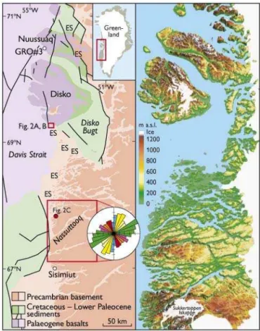
Fig. 1. Left: Study area with Precambrian basement and cover rocks that are crucial for determining the relative age of palaeosurfaces. The rose diagram summarises the regional lineament patterns, based on field mapping in the framed area (cf. Wilson et al. 2006). The relationship between lineaments onshore and offshore allows for a relative event chronology; colouring refers to timing (cf. Fig. 3). Position of GRO#3 well indicated. ES, etch surface of Late Mesozoic – Paleocene age. Note its position close to cover rocks. Modified from Bonow et al. (2006a).
ously over geological time, but are shortened at a rate that depends on the prevailing temperature, until at temperatures higher than c. 120°C tracks are totally erased (‘annealing’). Fission track age and track length data provide the basis for estimating the time at which a sample began to cool from a palaeo-thermal maximum as well as the magnitude of the maximum palaeotemperature. Cooling can be interpreted as either change of heat-flow within the crust or erosion of over-lying rocks (e.g. Green et al. 2002).
Structural analysis of faults and fracture systems aims to establish a relative chronology of tectonic movements that have changed the stress field, as a change will lead to the for-mation of a new set of faults and possibly the reactivation of older ones. Structural analysis of the area between Nuussuaq and Sisimiut forms the basis for a regional model, explaining different tectonic movements through time (Wilson et al. 2006).
Key results
Geology. The Cretaceous–Palaeogene sedimentary and vol-canic successions within the Nuussuaq Basin record deep incision of valleys in the Maastrichtian and early Paleocene (e.g. Dam et al. 1998), subsidence during volcanism, and deposition of marine sediments within the volcanic succes-sion now at high elevation (Piasecki et al. 1992), which are evidence that both uplift and subsidence of kilometre scale took place during and after rifting (Chalmers et al. 1999). During the Palaeogene the basalts offshore (and probably onshore, Japsen et al. 2006a) became buried below sedi-ments. Seismic sections west of Nuussuaq show that Palaeo-gene and younger sequences have been tilted seawards and truncated at a late date (Chalmers 2000).
34
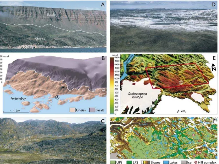
Fig. 2. Views of the etch surface (ES) and the upper and lower planation surfaces (UPS and LPS) formed in basement rocks. A: The re-exposed ES at Fortunebay, southern Disko. The white line shows the approximate border between Paleocene basalt and gneiss. Area location in Fig. 1. Photo location in B. B: 3D model of the Fortunebay area. Note the Oligocene–Miocene planation surface at high elevation across the basalt. Modified from Bonow (2005).
Geomorphology. Three different palaeosurfaces in the Pre -cam brian basement have been identified in West Greenland, viz. a surface formed by deep weathering and stripping of the weathering mantle (etch surface, ES), and an upper and lower planation surface (UPS and LPS; Bonow 2005; Bonow et al. 2006a, b). The ES is characterised by distinct hills (Fig. 2A) and re ceived its final shape in part prior to the deposition of Upper Cretaceous deltaic sediments and in part prior to the extrusion of Palaeogene basalts (Fig. 2B). The ES can mainly be identified at low elevations and close to cover rocks (Figs 1, 2C). The UPS has low relative relief compared to the ES (Fig. 2D) and must be younger as it cuts across both mid-Eocene basalts and the etch surface. The UPS forms the sum-mits of differentially tilted, fault-bounded tectonic blocks. A planation surface cannot be formed as an inclined plain because any tilt would cause valleys to incise and the relief to rejuvenate towards the baselevel (Bonow et al. 2006b, fig. 6). The LPS was formed in response to lowered baselevel (uplift) and became incised into the UPS (Fig. 2E). Furthermore, summits of distinct hill complexes above the UPS (Fig. 2F)
may relate to a sub-Ordovician palaeosurface because rem-nants of Lower Palaeozoic rocks suggest that West Greenland may have had a long-lasting Palaeozoic cover (Bonow et al. 2006a). Consequently, erosion of Precambrian basement rocks has been limited since the early Palaeozoic, but this does not ex clude deposition and subsequent removal of thick sequences of Phanerozoic cover rock as indicated by AFTA data.
Thermochronology. AFTA data from Cretaceous sedimen-tary rocks define three major Cenozoic cooling episodes, while basement samples define major Triassic and Jurassic cooling episodes (related to rifting?), and also earlier (Palaeo zoic) episodes (Table 1). The deepest samples in the 3 km deep GRO#3 well on Nuussuaq are totally annealed (Fig. 1; Japsen
et al. 2005). The progressive development of fission tracks can therefore be followed through the sedimentary section, giving a rare opportunity to resolve the details of the late Ceno zoic cooling history. Oligocene cooling involved both exhu -mation and a decrease in basal heat flow, while Miocene and Pliocene cooling episodes were dominantly related to exhu -mation. The two latest cooling events constrain the cooling events into the present.
Faults and fractures.Analysis of regional lineament trends shows five main systems that fit a two-stage model (Wilson et al. 2006). A system of N–S- and NNW–SSE-trending nor-mal faults reflects the fault patterns in the Davis Strait during the Late Cretaceous to Paleocene. This system was over-printed and reactivated by strike-slip faults associated with a later NNE–SSWtrending sinistral wrench system that re -flects the development of the Ungava transform system dur-ing the Eocene.
35
The model and future implementation
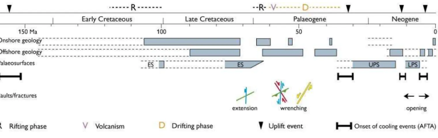
Our model shows where in time independent constrained data exist and time-frames for uncertainties and lack of data (Fig. 3). The model shows that each discipline has long peri-ods of no data, but when combined only few periperi-ods have no data representation at all. In particular, landscape analysis and AFTA data complement each other, because palaeosurfaces show that rock was exposed at the landsurface, whereas AFTA data indicate when and by how much a palaeosurface has been buried. This approach shows that the present summits were buried below up to 1 km of rocks prior to Eocene–Oligocene uplift, and that the UPS formed during the Oligocene– Miocene due to stable baselevel conditions. Similarly, uplift in the late Miocene resulted in valley incision (the LPS) and tilting of the UPS. Final uplift in the ?Pliocene resulted in the present-day mountains. Late uplift reactivated and opened the fault and fracture systems, thus facilitating both weather-ing and the development of a coastal escarpment (Bonow et al. 2006c). Our model is also used in ongoing uplift studies in South-West Greenland (Japsen et al. 2006b).
The integration of data from geomorphology, thermo -chrono logy, geology and fault/fracture patterns to show that the present landscape of West Greenland is the result of tec-tonic movements throughout the Phanerozoic with signifi-cant movements also in the Neogene and even into the present (Fig. 3). The approach presented here may be applied to understand landscape development along other passive continental margins.
Acknowledgements
This work was supported by the Carlsberg Foundation, the Bureau of Minerals and Petroleum, the Danish Natural Science Research Council, the Swedish Research Council, Arktisk Station, Stiftelsen Margit Althins stipendiefond, Svenska Sällskapet för Antropologi och Geografi and John Söderbergs stiftelse.
References
Bonow, J.M. 2005: Re-exposed basement landforms in the Disko region, West Greenland – disregarded data for estimation of glacial erosion and uplift modelling. Geomorphology 72, 106–127.
Bonow, J.M., Lidmar-Bergström, K. & Japsen, P. 2006a: Palaeosurfaces in central West Greenland as reference for identification of tectonic movements and estimation of erosion. Global and Planetary Change
50, 161–183.
Bonow, J.M., Japsen, P., Lidmar-Bergström, K., Chalmers, J.A. & Pedersen, A.K. 2006b: Cenozoic uplift of Nuussuaq and Disko, West Greenland – elevated erosion surfaces as uplift markers of a passive margin. Geomorphology 80, 325–337.
Bonow, J.M., Klint, K.E.S. & Japsen, P. 2006c: The Nordre Isortoq Escarpment. Field report summer 2005. Danmarks og Grønlands Geologiske Undersøgelse Rapport 2006/13, 68 pp.
Chalmers, J.A. 2000: Offshore evidence for Neogene uplift in central West Greenland. Global and Planetary Change 24, 311–318.
Chalmers, J.A., Pulvertaft, C., Marcussen, C. & Pedersen, A.K. 1999: New insight into the structure of the Nuussuaq Basin, central West Green -land. Marine and Petroleum Geology 16, 197–224.
Dalhoff, F., Chalmers, J.A., Gregersen, U., Nøhr-Hansen, H., Rasmussen, J.A. & Sheldon, E. 2003: Mapping and facies analysis of Paleocene – mid-Eocene seismic sequences, offshore southern West Greenland. Marine and Petroleum Geology 20, 935–986.
Dam, G., Larsen, M. & Sønderholm, M. 1998: Sedimentary response to mantle plumes: implications from Paleocene onshore successions, West and East Greenland. Geology 26, 207–210.
Green, P.F., Duddy, I.R. & Hegarty, K.A. 2002: Quantifying exhumation from apatite fission-track analysis and vitrinite reflectance data: preci-sion, accuracy and latest results from the Atlantic margin of NW Europe. In: Doré, A.G. et al. (eds): Exhumation of the North Atlantic margin: timing, mechanisms and implications for petroleum explo-ration. Geological Society Special Publication (London) 196, 331–354. Japsen, P., Green, P.F. & Chalmers, J.A. 2005: Separation of Palaeogene and Neogene uplift on Nuussuaq, West Greenland. Journal of the Geological Society (London) 162, 299–314.
Japsen, P., Bonow, J.M., Green, P.F., Chalmers, J.A. & Lidmar-Bergström, K. 2006a: Elevated, passive continental margins: long-term highs or Neogene uplifts? New evidence from West Greenland. Earth and Planetary Science Letters 248, 315–324.
Japsen, P., Bonow, J.M., Peulvast, J.-P. & Wilson, R.W. 2006b: Uplift, ero-sion and fault reactivation in southern West and South Greenland. Field report summer 2006. Danmarks og Grønlands Geologiske Undersøgelse Rapport 2006/63, 77 pp.
Pedersen, A.K., Larsen, L.M., Pedersen, G.K. & Dueholm, K.S. 2006: Five slices through the Nuussuaq Basin, West Greenland. Geological Survey of Denmark and Greenland Bulletin 10, 53–56.
Piasecki, S. 2003: Neogene dinoflagellate cysts from Davis Strait, offshore West Greenland. Marine and Petroleum Geology 20, 1075–1088. Piasecki, S., Larsen, L.M., Pedersen, A.K. & Pedersen, G.K. 1992:
Palynostratigraphy of the lower Tertiary volcanics and marine clastic sediments in the southern part of the West Greenland basin: implica-tions for the timing and duration of the volcanism. Rapport Grønlands Geologiske Undersøgelse 154, 13–31.
Wilson, R.W., Klint, K.E.S., van Gool, J.A.M., McCaffrey, K.J.W., Holdsworth, R.E. & Chalmers, J.A. 2006: Faults and fractures in central West Greenland: on-shore expression of continental break-up and sea-floor spreading in the Labrador – Baffin Bay Sea. Geological Survey of Denmark and Greenland Bulletin 11, 185–204.
Authors’ addresses
J.M.B., P.J., J.A.C., K.E.S.K. & J.A.M.v.G., Geological Survey of Denmark and Greenland, Øster Voldgade 10, DK-1350 Copenhagen K, Denmark. E-mail: jbon@geus.dk
P.F.G., Geotrack International, 37 Melville Road, Brunswick West, Victoria 3055, Australia.
R.W.W., Reactivation Research Group, Department of Earth Sciences, University of Durham, Durham, DH1 3LE, UK. K.L.-B., Department of Physical Geography and Quaternary Geology, Stockholm University, SE-106 91 Stockholm, Sweden. A.K.P., Geological Museum, University of Copenhagen, Øster Voldgade 5–7, DK-1350 Copenhagen K, Denmark.