65
In 2004 the Geological Survey of Denmark and Greenland (GEUS) initiated a study of the origin and tectono-meta-morphic evolution of greenstone belts and important regio-nal structures in the central Godthåbsfjord region, southern West Greenland (Fig. 1; Hollis et al. 2004). Like other Ar-chaean belts worldwide, these greenstone belts are locally host to gold mineralisation. Their complexity requires a com-bination of detailed geological mapping, geochemistry, pe-trographic work and geochronological studies to develop models of their geological setting, evolution and gold minerali-sation.
Regional geology
The greenstone belts in the Godthåbsfjord region represent remnants of Archaean intrusive and extrusive mafic rocks, and minor chemical and clastic sediments. These were once
thought to be dismembered parts of the same greenstone belt, but are now known to belong to unrelated groups of differ-ent ages, occurring within several distinct contindiffer-ental crustal terranes – the Færingehavn, Akia and Tre Brødre terranes (Fig. 1; e.g. Schiøtte et al. 1988). These terranes were amal-gamated at 2950–2700 Ma (e.g. Friend & Nutman 2005). The 3850–3300 Ma Færingehavn terrane largely comprises early Archaean tonalitic orthogneiss, granite, ultramafic and gabbroic rocks, together with rocks of inferred supracrustal origin, all of which are intruded by mafic Ameralik dykes. The 3200–2975 Ma Akia terrane comprises orthogneiss and greenstones. The 2826–2750 Ma Tre Brødre terrane, which is in tectonic contact with the Færingehavn terrane in many parts of the central Godthåbsfjord region, and also with the Akia terrane (Fig. 1), is dominated by late Archaean (c. 2825 Ma) orthogneiss, but also includes metasedimentary and mafic volcanic rocks and gabbro-anorthosite. The boundary
Greenstone belts in the central Godthåbsfjord region,
southern West Greenland
Julie A. Hollis, Jeroen A.M. van Gool, Agnete Steenfelt and Adam A. Garde
Geological Survey of Denmark and Greenland Bulletin 7, 65–68 (2005) © GEUS, 2005
Atan eq f
ault
Ivinngu it fa
ult
3 1
2
Qus suk
God thåb
sfjo
rd
Store Malene
Storø
Sermitsiaq
Bjørn e-øen
Qussuk peninsula
Q
Kangersuneq
Sto rø s
hear zo
ne
Kobb efjordf
ault
Ko bbefjor
d
Akia (c. 3200–2975 Ma)
Tre Brødre (c. 2826–2750 Ma) Færingehavn
(c. 3850–3300 Ma)
Kapisillik (c. 3075–2960 Ma) Tasiusarsuaq (c. 3000–2800 Ma) Amphibolite Metasedimentary rocks Qorqût granite Archaean terranes
64°15´N 64°30´N 64°45´N
51°30´W 51°00´W
between the Tre Brødre and Akia terranes is the high-grade mylonitic Ivinnguit fault (c. 2720–2710 Ma; e.g. Friend et al. 1987), which can be traced continuously for tens of kilome-tres (Fig. 1). The emplacement of the Qôrqut sheeted granite complex (c. 2530 Ma; Fig. 1) in central Godthåbsfjord post-dated regional terrane assembly. Post-Archaean events in-clude emplacement of Proterozoic dolerite dykes (2400 –2200 Ma) and regional-scale faulting, e.g. the NE–SW-trending Kobbefjord and Ataneq faults (Fig. 1).
Greenstone belts: structure, lithology and
mineralogy
Three distinct NNE–SSW-trending greenstone belts can be recognised in the central Godthåbsfjord region: the Storø, Bjørneøen and Qussuk greenstone belts (Fig. 1). Based on cross-cutting relationships and existing geochronological data, these belts lie in the Akia (Qussuk and Bjørneøen belts) and the Tre Brødre (Storø belt) terranes (Fig. 1).
The Bjørneøen greenstone belt
The Bjørneøen greenstone belt (> 2975 Ma, Akia terrane) is a continuous NNE–SSW-trending belt which shows tight to isoclinal folding, large-scale, upright folding, NW-directed thrusting along NE–SW-striking high strain zones, and late brittle to semi-ductile reworking of ductile structures. The Ivinnguit fault forms a tectonic base to part of the Bjørneøen greenstone belt (Fig. 1).
The belt is dominated by mafic amphibolites, with lesser intermediate schist, metagabbro and ultramafic rocks, and minor garnet- and tourmaline-rich rocks of inferred sedi-mentary and volcanic origin. The mafic amphibolites are
variably calc-silicate banded with rare pillow structures pre-served in areas of low strain (Fig. 2). Schists of intermediate composition also preserve angular clasts of inferred volcanic origin in areas of low strain. Thin packages of layered metasedimentary and metavolcanic rocks are seen at Store Malene, Sermitsiaq and south-east Bjørneøen (Fig. 1) and commonly contain tourmaline-rich layers; in some cases they define refolded folds. They have been interpreted as strata-bound syngenetic deposits, closely associated with the tung-sten mineral scheelite (CaWSO4; Appel & Garde 1987). Laminated quartzofeldspathic rocks may represent tuffs. Relatively minor units of garnet-bearing quartzite and gar-net-biotite schist ± muscovite, zoisite, chlorite and tourma-line occur, along with anthophyllite-cordierite-bearing mag-nesian schists and cordierite-bearing quartzitic rocks. This belt reached only upper greenschist to lower amphibolite facies conditions.
The Qussuk greenstone belts
The Qussuk greenstone belts (> 2975 Ma, Akia terrane) may be contiguous with the Bjørneøen belt. They occur as NNE–SSW-trending, isoclinally folded and steeply dipping units of kilometre-thickness. Rock types present include intermediate and mafic amphibolites, with lesser amounts of metagabbro, ultramafic rocks and minor garnet- and tour-maline-rich rocks of inferred sedimentary and volcanic ori-gin. The amphibolite units are dominated by rocks of in-termediate composition. In areas of low strain these preserve decimetre-scale angular clasts inferred to be volcanic in origin (Fig. 3). These fragmental rocks commonly occur in associa-tion with laminated quartzofeldspathic rocks that may have been tuffs. Rare quartz-rich garnet and locally
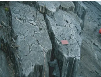
tourmaline-66
Fig. 2. Deformed pillow lavas on south-east Bjørneøen, looking east, showing eastward younging direction.
bearing rocks may be volcanogenic-exhalative or hydrother-mal in origin, similar to the tourhydrother-maline-rich rocks from the Bjørneøen belt.
The Storø greenstone belt
The Storø greenstone belt is interpreted as part of the Tre Brødre terrane because of intrusive contacts with inferred late Archaean orthogneiss at the structural base of the belt on Storø. The outcrop of this belt on Storø – the focus of gold exploration in the region – is largely controlled by the 200–300 m wide Storø shear zone and associated kilometre-scale folds (Fig. 4). The Storø shear zone runs parallel to the older Ivinnguit fault along the north-west coast of Storø, and has excised part of the belt along this section (Fig. 1). Outside the Storø shear zone, the belt preserves tight to isoclinal folds reflecting earlier deformation.
The Storø belt is dominated by mafic amphibolites with rare pillow structures, banded amphibolites, mica schists, sil-limanite- and mica-bearing quartzites, thin iron formations, and lenses of ultramafic rocks. A gabbro-anorthosite body at the structural base of the belt forms the core of two large dou-bly plunging antiforms in the hanging wall of the Storø shear zone. North and south of Storø the belt thins and metasedi-mentary rocks are rare. Pelitic schists throughout the Storø belt preserve amphibolite facies mineral assemblages, which pre-date the Storø shear zone and include garnet, biotite, pla-gioclase, quartz ± sillimanite ± muscovite ± cordierite ± graphite ± staurolite.
Primary depositional environments and
plate tectonic setting
In the Bjørneøen belt the common occurrence of tourmaline (indicating boron-rich compositions) and scheelite in strata-bound settings, together with the spatial association with pil-low structures in mafic amphibolite, are consistent with a submarine exhalative setting with associated alteration via hot circulating fluids (cf. Appel & Garde 1987). In the Qussuk belts tourmaline-rich quartzitic rocks may be indica-tive of a similar setting. Mafic amphibolites from the Qussuk and Bjørneøen belts preserve flat rare-earth element (REE) spectra consistent with an oceanic plateau environment. However, intermediate rocks from both belts show elevated light REE spectra, and some mafic amphibolites from the Bjørneøen belt show mixed signatures, suggestive of a possi-ble island-arc environment. This indicates more than one im-portant magmatic source for the Qussuk and Bjørneøen belts.
The gabbro-anorthosite body at the structural base of the Storø greenstone belt may be indicative of an oceanic, rift-related setting, an interpretation supported by rare pillow structures in mafic amphibolites and the occurrence of ultra-mafic lenses that may represent former dykes. However, the inferred tuffite origin of intermediate amphibolite and the occurrence of quartzite units indicate a significant continen-tal source. These observations fit with an island-arc proximal to a continent, or a change in environment during formation of this belt. Further geochemical analyses and geochronolo-gical constraints are required.
67
Fig. 4. East-closing synform in the footwall of the Storø shear zone, on the south-western slopes of Qingaaq mountain on Storø (see Fig. 1 for loca-tion).
metadolerite
NW SE
anorthosite 1190 m
orthogneiss
Storø Shear Zone in greenstone belt
sub-vertical dip moderate NW dip
68
Mineral occurrences and implications for
mineral exploration
Regional studies have identified a NNE–SSW-trending zone through central Godthåbsfjord with anomalous gold, and gold pathfinder elements (Steenfelt et al. 2003). This zone is parallel to the trace of the Ivinnguit fault. High gold values have been reported from mica schists and amphibolite on Storø (NunaMinerals A/S, licence number 2002/07; e.g. Appel et al. 2000), where exploration and prospecting activi-ties continue.
Trace element data for rock, stream sediment and soil sam-ples obtained in 2004 corroborate the high gold values previ-ously found on Bjørneøen (Skyseth 1998; Smith 1998), but also identify previously unrecognised gold occurrences on the Qussuk peninsula. Here values of 1.4 and 2.3 ppm Au were measured in samples of respectively an intermediate amphi-bolite and a tourmaline-bearing quartzitic rock of inferred hydrothermal origin. This may be indicative of a link be-tween early hydrothermal processes (possibly in a submarine volcanic environment) and gold mineralisation.
Mapping in 2004 and geochemical analyses of samples from altered zones related to shear zones and faults (inclu-ding the Ivinnguit and Ataneq faults) did not identify a rela-tionship between these structures and anomalous gold values. In fact, field relationships point to mineralisation early in the tectono-metamorphic history. Geochemical results show gold occurrences in all three greenstone belts and – particu-larly in the case of the Qussuk belt – not necessarily related to shear zone or fault structures. The NNE–SSW-trending anomalous zone may simply be a reflection of the trend of greenstone belts in this region, rather than indicative of a relationship to NNE–SSW-trending structures, such as the Ivinnguit fault terrane boundary.
Further work
Further geochemical analyses of key major and trace elements are required to build on correlations and develop models for primary tectonic settings. Important issues include the deter-mination of absolute timing constraints on regional struc-tures, the deposition history of sedimentary and volcanic rocks, and the metamorphic history. Over 70 structurally constrained samples have been collected for this purpose. Further fieldwork is also required to investigate some of the important findings, and to extend the study to greenstone belts further afield in the Godthåbsfjord region.
Acknowledgements
This project was financially supported by the Bureau of Minerals and Petroleum, Nuuk, Greenland and undertaken in parallel with related GEUS projects.
References
Appel, P.W.U. & Garde, A.A. 1987: Stratabound scheelite and stratiform tourmalinites in the Archaean Malene supracrustal rocks, southern West Greenland. Bulletin Grønlands Geologiske Undersøgelse 156, 26 pp.
Appel, P.W.U., Bliss, I.C., Coller, D.W., Grahl-Madsen, L. & Pedersen, J.S. 2000: Recent Au discoveries in Archaean rocks of central West Greenland. Transactions of the Institution of Mining and Metallurgy (Sect. B: Appl. Earth Sci.) 109, B34–B41.
Friend, C.R.L. & Nutman, A.P. 2005: New pieces to the Archaean terrane jigsaw puzzle in the Nuuk region, southern West Greenland: steps in transforming a simple insight into a complex regional tectonothermal model. Journal of the Geological Society (London) 162, 147–162. Friend, C.R.L., Nutman, A.P. & McGregor, V.R. 1987: Late-Archaean
tec-tonics in the Færingehavn – Tre Brødre area, south of Buksefjorden, southern West Greenland. Journal of the Geological Society (London) 144, 369–376.
Hollis, J.A., van Gool, J.A.M., Steenfelt, A. & Garde, A.A. 2004: Greenstone belts in the central Godthåbsfjord region, southern West Greenland: preliminary results from field work in 2004. Danmarks og Grønlands Geologiske Undersøgelse Rapport 2004/110, 110 pp. + 1 DVD.
Schiøtte, L., Compston, W. & Bridgwater, D. 1988: Late Archaean ages for the deposition of clastic sediments belonging to the Malene supra-crustals, southern West Greenland: evidence from an ion probe U-Pb zircon study. Earth and Planetary Science Letters 87, 45–58. Skyseth, T. 1998: Gold exploration on Storø 1997, South West Greenland,
25 pp. Unpublished report, NunaOil A/S, Nuuk, Greenland (in archives of Geological Survey of Denmark and Greenland, GEUS Report File 21601).
Smith, G.M. 1998: Report on the structure and geometry of the gold mine-ralization at Qingaq Storø, Nuukfjord, South West Greenland, 13 pp. Unpublished report, NunaOil A/S, Nuuk, Greenland (in archives of Geological Survey of Denmark and Greenland, GEUS Report File 21602).
Steenfelt, A., Moberg, E. & Appel, P.W.U. 2003: Geochemical data indica-tive of mineral occurrences. In: Appel, P.W.U. et al.: Economic poten-tial of the greenstone belts in the Nuuk area. General geology and evaluation of compiled geophysical, geochemical and ore geological data. Danmarks og Grønlands Geologiske Undersøgelse Rapport 2003/94, 58–66.
Authors’ address