THE SPATIAL DISTRIBUTION OF SETTLEMENTS IN
THE BÂRG
Ă
U MOUNTAINS
CORNEL COSTEA
1ABSTRACT – Based of the specific geomorphologic and hydrologic background, the Bârgău
Mountains have faced an extensive and prolonged human process, the main vectors being the two morpho - hydrographic axes (Ilva-Leşu and Bârgău-Bistriţa), including the interfluvial areas, which
were introduced, in different degrees, into the humanized territory. Thus, two habitational zones are distinguished, the one of Ilva and Leşu (in the central part) and the one of Bârgău and Bistriţa, in the
south. The present study aims at emphasizing the main aspects connected to the territorial distribution of habitats in the Bârgău Mountains, from a double perspective: quantitative and morphological. The analysis of the quantitative distribution of settlements was made starting from the calculation of some synthetic indicators (the settlement density, the area coefficient, the dispersion indicator, the average distance between two localities). As altitude plays an important role in the spatial distribution of habitats, four “generations” of settlements were identified depending on the elevation levels. The most numerous localities in the Bârgău Mountains (16 out of the total of 20)
are situated between 601 and 1100 m, illustrating the specific morphometrical features of the territory. Besides the role that the terrain plays in the distribution of habitats, the swarming processes (through displacement and saltation) have to be mentioned, as they contributed to the confinement of the forest surfaces, so that, now, the Bârgău Mountains represent a strongly humanized area.
Keywords: quantitative distribution, morphological distribution, settlement density, area coefficient, dispersion indicator, average distance
INTRODUCTION
The Bârgău Mountains, through the presence of Ilva and Leşu, which cross through the middle
the mountain unit, as well as Bârgău and Bistriţa, at the southern margin of the mountain space, have
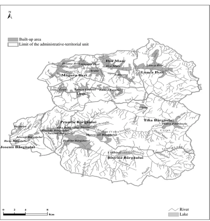
faced an extensive anthropogenic process, whose beginning looses itself in the mists of time. It is the space in which, based on the archaeological research performed in the area, the presence of man dates back to at least the Neolithic (around 5500 – 1900 BC). Each historical era has left traces of the presence of man in this mountain area, the specific features of the landscape leaving their mark both on the establishment of the first settlements (temporary), and also on the subsequent developments of the settlement system of the Bârgău Mountains (Figure 1).
The spatial distribution of settlements is a very important component in the analysis of the habitat of a certain geographic space and it could be approached from two points of view: quantitative
and morphologic.
THE QUANTITATIVE DISTRIBUTION
It is highlighted with the help of some indicators: the settlement density, the area coefficient, the dispersion indicator, and the average distance between two localities. The data on the basis of
which these indicators were calculated are those from the 2002 census.
a) The settlement density represents a key synthetic indicator in the analysis of the territorial
distribution of settlements. The Bârgău Mountains cover an area of 1,307 km², on which 21 rural
1 Ph.D. student, Babeş-Bolyai University, Faculty of Geography, 5-7 Clinicilor Street, 400006, Cluj-Napoca, Romania.
settlements are present. Thus, it results an average density of 1.6 localities/100 km². Consequently, the space of the Bârgău Mountains belongs to the category of regions with low density of settlements, the value being much under the national average of 5.6 localities/100 km². The low density of settlements is a consequence of the high share of large and very large villages (57.1%), to which medium-sized villages are added (19.05% of the total number of rural settlements in the Bârgău Mountains). The morpho – hydrographic axes represented vectors of territorial colonization, favouring the framing of some large and very large rural habitation entities.
Figure 1. Bârgău Mountains. The settlement network (2011)
At the level of the territory, there are obvious contrasts in what concerns the density of settlements, from 1.1 localities/100 km², in the case of Bistriţa Bârgăului and Lunca Ilvei communes, to 7.2 localities/100 km², in the case of Josenii Bârgăului commune. Bistriţa Bârgăului commune covers a larger area (186.27 km²), which represents 14.3% of the entire Bârgău Mountains area, in the conditions
Built-up area
Limit of the administrative-territorial unit
Figure 2. Bârgău Mountains. The settlement density (2002)
in which it has only two villages. In the case of Lunca Ilvei commune, the low density of settlements is owed to the fact that this administrative territorial unit comprises only one village (Table 1).
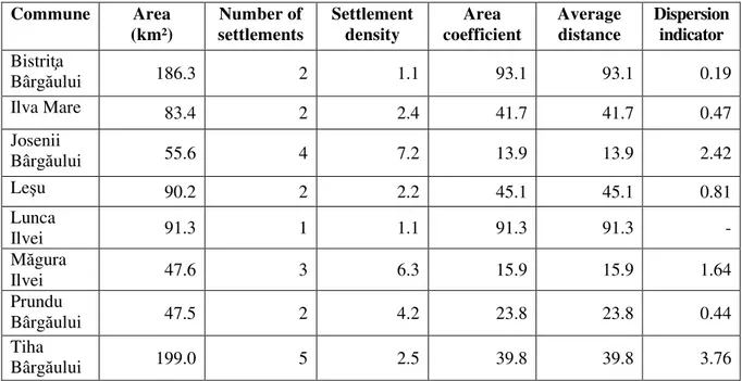
Table 1. Thequantitative distribution of settlements in the Bârgău Mountains Commune Area
(km²) Number of settlements Settlement density Area coefficient Average distance Dispersion indicator Bistriţa
Bârgăului 186.3 2 1.1 93.1 93.1 0.19
Ilva Mare 83.4 2 2.4 41.7 41.7 0.47
Josenii
Bârgăului 55.6 4 7.2 13.9 13.9 2.42
Leşu 90.2 2 2.2 45.1 45.1 0.81
Lunca
Ilvei 91.3 1 1.1 91.3 91.3 -
Măgura
Ilvei 47.6 3 6.3 15.9 15.9 1.64
Prundu
Bârgăului 47.5 2 4.2 23.8 23.8 0.44
Tiha
Bârgăului 199.0 5 2.5 39.8 39.8 3.76
The density of settlements exceeds the average of the region in all the other communes in the Bârgău Mountains. Two groups are noticed in relation to the density of settlements at national level: communes having a density below the national average (Ilva Mare, Leşu, Prundu Bârgăului and Tiha Bârgăului) and communes having densities over the national average (Josenii Bârgăului and Măgura Ilvei). In the case of Josenii Bârgăului commune, the high density of settlements is a consequence of the great number of villages (4) that occupy a small area (55.58 km²). One can thus notice a heterogeneous distribution of this indicator in what concerns the territorial profile, at the level of the Tiha - Bistriţa morpho - hydrographic axis emphasizing the increase in the density of settlements from upstream to downstream: Bistriţa Bârgăului (1.1), Tiha Bârgăului (2.5), Prundu Bârgăului (4.2) and Josenii Bârgăului (7.2) (Figure 2).
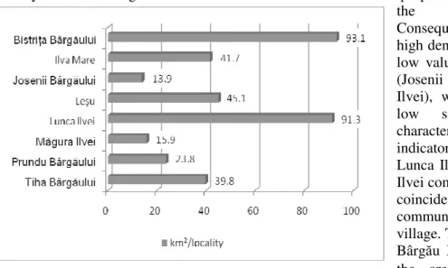
b) The area coefficient represents the relation between the area and the number of settlements,
namely the area covered by one settlement. At the level of the Bârgău Mountains, the value of the area coefficient is of 62.2 km²/locality, value which is much above the national average (18.1 km²/locality). The high level of the area coefficient reflects the reality of the territory, as the Bârgău Mountains occupy an area of 1,307 km² and include 21 localities, mostly large rural settlements, both in terms of area and the demographic aspect.
At the level of communes, the area coefficient varies between 13.9 km²/locality and 93.1 km²/ locality. It is interesting that this indicator is in a relation of inverse proportionality in comparison with the settlement density. Consequently, the communes with high density of settlements register low values of the area coefficient (Josenii Bârgăului and Măgura Ilvei), while the communes with low settlement density are characterized by high values of this indicator (Bistriţa Bârgăului and Lunca Ilvei). In the case of Lunca Ilvei commune, the area coefficient coincides with the area of the commune as it comprises a single village. The other communes in the Bârgău Mountains have values of the area coefficient under 50 (Figure 3).
Thus, Prundu Bârgăului commune, having only two villages, has an area coefficient of 23.8 km²/locality, in the conditions in which its area does not exceed 50 km². On the other hand, Tiha Bârgăului commune, although it belongs to the category of large administrative-territorial units (199 km²), the average area occupied by a settlement does not exceed 40 km², being formed of 5 villages.
c) The average distancebetween two localities is obtained on the basis of the area coefficient
(a), according to the formula: m.d. = 1.2√a. The average distance between two localities in the Bârgău Mountains is 9.5 km, which is above the national average of 5.1 km. It must be mentioned that in the case of Lunca Ilvei commune, the average distance between two localities has not been calculated because it has only one village. This indicator is in direct proportionality with the area coefficient, on the basis of which it is calculated. The average distance between two localities varies between 4.5 km (Josenii Bârgăului) and 11.6 km (Bistriţa Bârgăului). Măgura Ilvei commune stands out through an average distance below the national one, being, however, less than 10 km (Figure 4).
Figure 3. Bârgău Mountains. The area coefficient (2002)
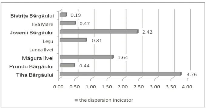
d) The dispersion indicator also highlights the territorial relations between settlements. In
order to obtain it, we have used A. Demangeon’s formula: Id = (N-N’)xn/N, where N – the total number of inhabitants; N’ – the number of inhabitants from the village of residence; n – the number of villages which are not residence. Similarly to the case of the average distance between two localities, the dispersion indicator could not be calculated for Lunca Ilvei commune, N being equal to N’.
The value of the dispersion indicator of the communes in the Bârgău Mountains ranges between 0.19 and 3.76. Thus, starting with the reality of the territory, one could make the following typology:
- communes with a very low dispersion indicator (0.1-1) are those which are formed of two villages (Bistriţa Bârgăului, Ilva Mare, Leşu and Prundu Bârgăului) and are included in the category of large villages from the population size viewpoint, with the exception of Prundu Bârgăului that belongs to the category of very large rural settlements;
- communes with a low dispersion indicator (1.1-2), such as Ilva Mare, composed of three villages, with the commune centre included in the group of large-sized villages;
- communes with a medium dispersion indicator (2.1-4) have the highest number of villages in the region (Josenii Bârgăului – 4 villages, Tiha Bârgăului – 5 villages) and large commune centres (more than 1500 inhabitants) (Figure 5).
Figure 5. Bârgău Mountains. The dispersion indicator (2002)
THE MORPHOLOGICAL DISTRIBUTION
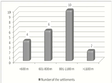
In the Bârgău Mountains, the depth of the terrain fragmentation exceeds 1000 m, if we consider the fact that the Bistriţa Valley is situated at the absolute altitude of 430 m in the perimeter of Rusu Bârgăului village and that the highest peak reaches 1611 m (Heniu Peak). In what concerns the distribution of settlements on elevation levels, the space narrows, from 430 m, at the exit of the Bistriţa river from the mountain space, at over 1100 m, in the eastern end, within Colibiţa village. For that reason, Colibiţa Depression is situated at an altitude ranging between 900 and 950 m and, as a result of dispersion, the farms are located on the mountain sides at altitudes that exceed 1100 m.
In case of a homogenous distribution of settlements in the Bârgău Mountains, a number of 5.3 settlements would be given to each altitude level. However, the morphological distribution is uneven, a small number of settlements situated at more than 1100 m height are noted (Piatra Fântânele and, partially, Colibiţa), while the majority of the localities (16) are grouped at two altitude levels: 601-800 m and 801-1100 m, respectively (Figure 6). The lower level, below 600 m, includes the villages that belong to Josenii Bârgăului commune, situated in the western part of the Bistriţa Valley (Mijlocenii Bârgăului, Josenii Bârgăului and Rusu Bârgăului) or in the area of Strâmba Ghat (the name sake village), through which the connection with Ilva Mică Depression is made. The settlements situated at altitudes ranging between 601 m and 800 m have developed in depression areas, where there is a slight tendency of dispersion on the mountainsides. They can be grouped, depending on their position within the region, in two alignments:
- the southern alignment, consisting of Bistriţa Bârgăului, Prundu Bârgăului and Susenii Bârgăului, developed in Prundu Bârgăului Depression, representing 50% of the settlements situatedat this elevation level;
- the northern alignment, including the localities of Măgura Ilvei, Poiana Ilvei and Leşu. In the case of Măgura Ilvei village, most part of the households was built on the 3-5 m terrace of the Ilva River. A fragment of the 10 m terrace located on the left bank of the river was preserved upstream the village church.
The greatest number of settlements in the Bârgău Mountains (10) has developed between 801 m – 1000 m, representing almost half of the total of settlements (45.6%).
This fact reflects the reality of the territory and the ability of the habitats to adapt to the conditions of the orographic factors. Two settlement groups can be highlighted at this level, too:
- the settlements between the Someşul Mare Valley and the Leşul Valley, presenting an
obvious tendency to dissipate on both banks of the Ilva. Lunca Ilvei village, axially developed along the Ilva River, mostly on the lower terrace of 3-5 m, has extended both to the north, reaching the border of Şanţ commune and also to the south, on the right bank of the upper stream of the Ilva until the border with Tiha Bârgăului commune. Arşiţa and Ivaneasa are situated on the interfluves of the Ilva and the Leşu, while Ciosa village is “nested” at the foot of Ciosa Hill (1187.2 m), between the upper stream of the Ilva and the upper stream of the Leşu.
- the settlements between the Leşul Valley and the Bistriţa Valley belong to Tiha Bârgăului commune and are characterized by an accentuated dissipation of farms, until they merge with those that belong to Colibiţa village, on the interfluves between the Bistriţa and the Tiha, in the case of Mureşenii Bârgăului village, or through the linear extension along the Tureacul brook (tributary to Bârgău). In this case, too, there are dissipated farms, to the north of the settlement towards Bârgău Hill (1362 m) and Erboasa Peak (1294 m).
CONCLUSIONS
The formation and evolution of the settlement network in the Bârgău Mountains were mainly conditioned by the orographic factor and by the existence of the hydrographic arteries. Due to the particular features of the natural environment, this mountain unit has represented, since ancient times, a favourable framework for the population to become sedentary. The forest, but also the other elements of the natural environment (climate, underground resources, morphological peculiarities, etc.) contributed in time to the extension of the habitation nuclei and to the occurrence of new ones.
The specific geographical-physical conditions determine an uneven distribution of settlements. Their density, at the level of the Bârgău Mountains, is below the national average as a consequence of the dominant presence of large and very large villages, which represent more than half of the total of settlements of the mountain unit. Significant differences have been noticed as regards the manifestation of the indicators expressing the distribution of settlements, both at the commune level and at subregion level. Thus, the density of localities is lower in the eastern part of the two morpho - hydrographic axes (Ilva-Leşu and Bârgău-Bistriţa) and higher in the central and western sectors.
The main vectors for the development of the settlement system were, without a doubt, the depression areas within the morpho-hydrographic axes (Ilva with Leşu and Bistriţa with Bârgău, respectively). The most representative habitats of the Bârgău Mountains are present at their level, although, in the case of some of them there is a tendency to dissipate on the mountainsides. On the other hand, the role that the processes of swarming (through displacement and saltation) from the mountain space to its contiguous territory (the Someşul Mare Valley) should not be neglected. Thus, Ilva Mare is a result of the swarming through saltation of some farms from the old settlements located in the Someşul Mare Valley (Rodna and Maieru). The same situation is found in the case of the settlements located the present perimeter of the commune Măgura Ilvei, but also of the localities Leşu and Poiana Ilvei. Consequently, the symbiosis between the natural environment (through its hallmark at the level of the mountain unit) and the processes induced by the human component has contributed to the genesis and the framing of the settlement system in the Bârgău Mountains, influencing both the number of settlements and the relation between them (the quantitative distribution) and also their
altitudinal distribution (the morphological distribution).
REFERENCES
COCEAN, P. (2004), Plan de Amenajare a Teritoriului Regiunii de Nord-Vest [North-West Region
Spatial Plan], Edit. Presa Universitară Clujeană, Cluj-Napoca.
CUCU, V. (1995), România. Geografie Umană [Romania. Human Geography], Edit. Glasul
Bucovinei, Iaşi.
ERDELI, G. (coord.) (1999), Dicţionar de geografie umană[Dictionary of Human Geography], Edit.
Corint, Bucureşti.
SURD, V. (1993), Introducere în geografia rurală [Introduction to Rural Geography], Edit.
Interferenţe, Cluj-Napoca.
*** (2002), Recensământul general al populaţiei din 18 martie 2002 [The General Census of