57
© 2013 GEUS. Geological Survey of Denmark and Greenland Bulletin 28, 57–60. Open access: www.geus.dk/publications/bull
Lineament mapping and geological history of the
Kangerlussuaq region, southern West Greenland
Knud Erik S. Klint, Jon Engström, Andrew Parmenter, Timo Ruskeeniemi,
Lillemor Claesson Liljedahl and Anne Lehtinen
How could future ice ages affect deep nuclear waste reposito-ries in crystalline basement rocks? Deep repositoreposito-ries may be affected by a number of glacially induced processes includ-ing, but not limited to, (1) fault activation or re-activation and associated seismicity, (2) changing hydraulic and chemi-cal groundwater dynamics and (3) enhanced erosion. Such processes are likely to affect not only man-made barriers in spent fuel repositories such as copper canisters and bentonite clay buffers, but also the rock masses that contain and iso-late the repositories. In order to increase our understand-ing of this problem, an international study (the Greenland Analogue Project) was set up in 2008. The aim of the study was to use crystalline bedrock at the margin of the Inland Ice near Kangerlussuaq airport in West Greenland as an
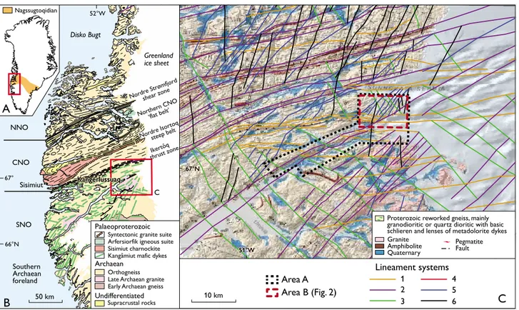
analogue for future nuclear fuel waste repositories affected by glaciation in Fennoscandia and Canada. Accordingly, a wide range of field surveys were conducted for the analogue project (Fig. 1). This paper describes a detailed structural investigation of lineament zones and the establishment of an event succession for fault and fracture zone evolution in central parts of the study area (Figs 1B, 2), as well as an inter-pretation of the distribution of fracture and fault zones with potentially increased permeability. Three deep holes were drilled in the study area, and instruments were installed in two of them for subsequent down-hole sampling and moni-toring of groundwater to a depth of c. 600 m. The cores were used to compare the subsurface fracture patterns with those established on the basis of surface mapping.
Fig. 1. A: Map of Greenland showing the extent of the Nagssugtoqidian orogen and the location of Fig. 1B (rectangle). B: Regional geology of southern
West Greenland, modified from Garde & Hollis (2010) and Garde & Marker (2010). CNO, NNO and SNO are central, northern and southern
Nagssug-toqidian orogen, respectively. C: Lineament map of the area around Kangerlussuaq airport. Areas A and B were mapped in detail. Sisimiut
Disko Bugt
Lineament systems
1 2 3
5 6 4
Area A Area B (Fig. 2)
10 km C
Proterozoic reworked gneiss, mainly granodioritic or quartz dioritic with basic schlieren and lenses of metadolorite dykes
Orthogneiss Late Archaean granite Early Archaean gneiss Syntectonic granite suite Arfersiorfik igneous suite Sisimiut charnockite Kangâmiut mafic dykes
Archaean Palaeoproterozoic
Undifferentiated
Supracrustal rocks
Granite Amphibolite Quaternary
Pegmatite Fault 51°W
51°W 67°N
67°N
steep belt shear zone
‘flat belt’ Northern CNO
C
52°W
A
Greenland ice sheet
67°
66°N
B 50 km
Southern Archaean foreland
Nagssugtoqidian
NNO
CNO
SNO
Kangerlussuaq Kangerlussuaq
58 58
Geological setting
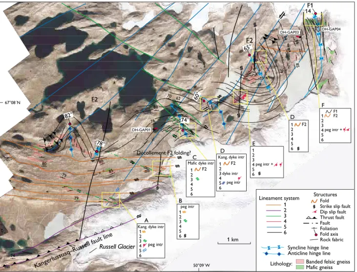
The Kangerlussuaq area is located close to the southern mar-gin of the c. 1.85 Ga old collisional Nagssugtoqidian orogen (van Gool et al. 2002). The study area covers a 100 × 50 km large area in front of and below the western margin of the In-land Ice (Fig. 1). Detailed geological mapping was carried out along a transect from Kangerlussuaq airport to the margin of the Inland Ice, and of a smaller area around the three drilling sites in the valley in front of the Inland Ice (Fig. 2).
The bedrock is mainly reworked Archaean orthogneiss with minor Palaeoproterozoic metavolcanic amphibolite and metasedimentary rocks that were deformed under high-grade metamorphic conditions during the Nagssugtoqidian orogeny (van Gool et al. 2002). The Nagssugtoqidian struc-tures are generally ductile and include a penetrative gneissic fabric, macroscale folds and pronounced shear zones.
Oc-casional, deformed mafic dykes also occur, mainly members of the rift-related Nagssugtoqidian Kangâmiut dyke swarm that preceded the Nagssugtoqidian orogeny (Mayborn & Lesher 2006). Brittle structures such as faults and fractures are abundant and were probably formed in a younger, shal-lower, colder and hence more rigid environment.
Regional lineament mapping and geology
of the study area
Most lineaments in crystalline rocks represent structural features such as faults and shear zones, rock fabrics and lineaments that were created at discontinuities due to dif-ferences in rheology or competence. Our lineament mapping comprised four steps. First, lineaments were identified using remotely sensed GIS-data compiled from aerial photographs,
Fig. 2. Aerial image of area B (Fig. 1C) with mapped and inferred rock fabric (foliation), rock types and structural elements. Local event stratigraphic models were developed for locations A–F. The macro-scale structures outline large-scale ductile folds overprinted by various shear and fault zones. Three deep holes were drilled (DH-GAP01, DH-GAP03 and DH-GAP04).
!!! !!!! ! ((( ((((( ((( ((( ( 65° 14
Mafic dyke intr
F1 F2
Kang. dyke intr 74° 60° DH-GAP01 DH-GAP03 DH-GAP04 78° 82°
Décollement F2 folding?
dyke intr ( 74 85 80 80 79 79 84 84 85 79 86 76 62 70 88 67°08´N
Kang. dyke intr
1 km
Fold Strike slip fault Dip slip fault Thrust fault Fault Foliation Fold axis Rock fabric
Banded felsic gneiss Mafic gneiss
Structures
Syncline hinge line Anticline hinge line 1 2 3 4 5 6
Kangerlussuaq–Russell fault line
Lineament system
peg intr +
50°09´W Lithology: F1 F2 F2 F2 A B C peg intr F2 peg intr peg intr D E
59 topographical and geological maps and geophysical data. The
second step was a descriptive and kinematic field analysis of the remotely detected lineaments. In the third step, a local event succession model was developed by determination of overprinting relationships. Finally, the local geological histo-ry of the Kangerlussuaq area was interpreted and correlated with the regional geological evolution (van Gool et al. 2002; Garde & Hollis 2010).
In order to provide an overview of the geological frame-work of the study area, the measured and interpreted struc-tures (foliation, fold hingeline, fault and shear zone traces) are shown on a high-resolution aerial image (Fig. 2). Close to the margin of the Inland Ice in the north-eastern part of the area, the bedrock is characterised by folded mafic gneiss that defines an open, NNW-trending and shallowly plung-ing (c. 14°) F1 fold structure. This structure gradually turns into a tight to isoclinal fold that can be traced southward and westward around an open, steeply-plunging, kilometre-scale F2 fold structure with a NW- to N-trending axial surface (Figs 1C, 2).
Five general lineament systems were outlined from the GIS analysis, and a sixth, subhorizontal system was identified by the field work, during which also the curvilinear nature of the foliation traces became apparent and highlighted the su-perposition of the F1 and F2 fold phases. On a regional scale, system 1 lineaments are generally distributed between the system 2 steep belts (Fig 1). These lineaments dominate in some parts of the southern study area and consist of ductile,
E–W-trending, 10–100 m wide, foliation-parallel, steeply in-clined and steeply N-dipping dextral shear zones (Figs 1C, 2). These shear zones may have acted as décollement planes for the F2 folding (see below).
System 2 lineaments constitute the most pronounced lin-ear feature and represent regional, SW-trending shlin-ear zones, including the zone outlining Søndre Strømfjord itself and es-pecially the northern margin of Sandflugtdalen that extends from Kangerlussuaq to Russell Glacier, hereafter named the Kangerlussuaq–Russell fault line. Other lineaments farther north with similar orientations (Fig. 1B) comprise the Iker-tôq zone (van der Molen 1984), the Nordre Isortoq steep belt and the Nordre Strømfjord shear zone (van Gool et al. 2002). Along the Kangerlussuaq–Russell fault line this lineament is dominated by sinistral strike-slip movement overprinting elements of thrust faulting dipping towards the north. Large boudins of deformed Kangâmiut mafic dykes (Mayborn & Lesher 2006) are included in this zone, which is therefore younger than the intrusion of the Kangâmiut dykes.
System 3 lineaments are a major NW-trending system along pronounced valleys and extend all the way up to Aas-siaat and Disko Bugt (Fig. 1A). Locally within the study area they form semi-brittle, sinistral strike-slip fault zones that displace the system 1 shear zones.
System 4 lineaments form oblique to sub-horizontal frac-ture systems trending NNE and are not represented by any pronounced topographic lineaments. These structures may also be related to a population of normal faults and younger, Age General tectonic events in central West Greenland Correlation to the Kangerlussuaq area
Table 1. Event succession of the Kangerlussuaq area compared with the general history of central West Greenland*
* based on van Gool et al. (2002) and Garde & Hollis (2010) † Kangerlussuaq–Russell fault line
>2.5 Ga (Archaean) Formation of ‘banded gneiss’ protoliths F1 folding + multiple healed structures
c. 2.04 Ga Continental rifting coupled with mafic dyke intrusions Intrusion of Kangâmiut mafic dykes
1.92–1.75 Ga Nagssugtoqidian orogen. Continental collision. Reworking, System 1 dextral, strike-slip shear and F2 folding folding and thrusting of gneiss/mafic rocks followed by System 2 WSW–ENE-trending faulting (K–R fl†)
peak metamorphism and large-scale folding during N–S Reactivation of Kangerlussuaq–Russell fault sinistral contraction. Finally formation of steep belts with sinistral strike slip
movements System 3 sinistral strike-slip shear zones
c. 1.78 to present day Various stress conditions. Formation and reactivation System 4 normal faults with shallow dip towards of open mode fractures at more shallow depths during SE and NW accompanied by pegmatite intrusions 20–25 km uplift
1.2 Ga Diamond-bearing, ultramafic lamprophyre intrusions S and W of Kangerlussuaq
600 Ma Kimberlite intrusions S and W of Kangerlussuaq
100–50 Ma Faulting related to sea-floor spreading during the System 5 sinistral strike-slip faults trending NE–SW opening of Labrador Sea and Baffin Bay. NNE–SSW System 6 dextral strike-slip faults trending N–S sinistral strike-slip faulting and conjugate dextral strike-
slip faulting
At least the last 2 Ma Repeated glaciations resulting in erosion, glacier-induced Reactivation of existing fault zones reactivation of fractures during glacial subsidence and
60 60
NNE-trending pegmatites orientated parallel with the nor-mal faults. They overprint the system 1 and 3 lineaments, but no cross-cutting relations to system 2 lineaments have been noticed.
System 5 lineaments are semi-brittle, sinistral, strike-slip faults trending NE and dipping to the NW. This system outlines the pronounced escarpment in the central to north-eastern part of the study area (Fig. 2). Local zones of WSW-striking thrust faults with both northerly and southerly dips are regarded as representing local transpression in a wrench fault system related to the overall system 5 lineaments.
System 6 lineaments consist of N–S-trending, brittle, dextral, strike-slip faults. This system may be conjugate with system 5. Lineaments with this orientation near the outer coast of central West Greenland have been related to the rift-ing between Greenland and Canada durrift-ing the last 100 Ma (Wilson et al. 2006).
Preliminary geological history
As demonstrated by its structural complexity (Fig. 2), the study area has undergone several episodes of deformation. These episodes have been compiled into a local event his-tory that recognises seven types of structural overprint (Ta-ble 1). Two stages of folding (F1 and F2) are identified. F1 may be of Archaean age, while F2 seems to be Nagssugtoqi-dian and contemporary with the system 1 shear zones, since the Kangâmiut dykes were folded during this event. The Kangerlussuaq–Russell fault line of system 2 lineaments has been reactivated with sinistral, strike-slip movement, dur-ing which the Kangâmiut dykes were deformed, but a clear, cross-cutting relation with systems 1 and 3 has not yet been documented. The system 3 lineaments clearly overprint system 1 and the F2 folds. The normal faulting and NNE- trending pegmatites of system 4 either indicate a general, extensional stress regime or local transtension during strike-slip movements. The timing of this event is highly specula-tive. The youngest geological events are related to the type 5 and 6 lineaments that form two, generally brittle, strike-slip
fault systems. These are also regarded as the primary hydrau-lic zones in the Kangerlussuaq area.
The absolute ages of the different types of ductile and brittle deformation are uncertain because of lack of radio-metric ages. However, in relative terms, it is suggested that the Kangerlussuaq–Russell fault line and most other semi-ductile shear zones are ancient features related to the Nagssugtoqidian orogeny (van Gool et al. 2002). The system 3 and 4 semi-brittle lineaments may be of intermediate ages related to postorogenic tectonic events, whereas the youngest and most brittle deformations may be related to the opening of the North Atlantic Ocean, the Labrador Sea and the Baf-fin Bay over the last 100 Ma (Wilson et al. 2006).
Acknowledgement
The study was funded by the Swedish, Finnish and Canadian nuclear waste management organisations.
References
Garde, A.A. & Hollis, J.A. 2010: A buried Palaeoproterozoic spreading ridge in the northern Nagssugtoqidian orogen, West Greenland. Geo-logical Society Special Publications (London) 338, 213–234. Garde, A.A. & Marker, M. 2010: Geological map of Greenland, 1:500 000,
Søndre Strømfjord – Nuussuaq. Copenhagen: Geological Survey of Denmark and Greenland.
Mayborn, K.R. & Lesher, C.E. 2006: Origin and evolution of the Kangâ-miut mafic dyke swarm, West Greenland. In: Garde, A.A. & Kals beek, F. (eds): Precambrian crustal evolution and Cretaceous–Palaeogene faulting in West Greenland. Geological Survey of Denmark and Green-land Bulletin 11, 61–86.
van Gool, J.A.M., Connelly, J.N., Marker, M. & Mengel, F.C. 2002: The Nagssugtoqidian orogen of West Greenland: tectonic evolution and regional correlations from a West Greenland perspective. Canadian Journal of Earth Sciences 39, 665–686.
van der Molen, I. 1984: Dykes and deformation in the Ikertôq zone of the Nagssugtoqidian at Søndre Strømfjord Airport, West Greenland. Bul-letin of the Geological Society of Denmark 32, 101–106.
Wilson, R.W., Klint, K.E.S., van Gool, J.A.M., McCaffrey, K.J.W., Holds-worth, R.E. & Chalmers, J.A. 2006: Faults and fractures in central West Greenland: onshore expression of continental break-up and sea-floor spreading in the Labrador – Baffin Bay Sea. Geological Survey of Denmark and Greenland Bulletin 11, 185–204.
Authors’ addresses
K.E.S.K., Geological Survey of Denmark and Greenland, Øster Voldgade 10, DK-1350 Copenhagen K, Denmark. E-mail: kesk@geus.dk J.E. & T.R., Geological Survey of Finland, P.O. Box 96, SF-02151 Espoo, Finland.
L.C.L., Swedish Nuclear Fuel and Waste Management Co, Box 250, SE-101 24, Stockholm, Sweden.