Neural Network Based Parking via Google Map Guidance
A.Saranya
1, Mr.R.Balamurugan
2II ME CSE1 Adhiparasakthi Engineering College Melmaruvathur-603319. Assistant Professor2 Adhiparasakthi Engineering College Melmaruvathur-603319.
Abstract
Intelligent transportation systems (ITS) focus to generate and spread creative services related to different transport modes for traffic management and hence enables the passenger informed about the traffic and to use the transport networks in a better way. Intelligent Trip Modeling System (ITMS) uses machine learning to forecast the traveling speed profile for a selected route based on the traffic information available at the trip starting time. The intelligent Parking Information Guidance System provides an eminent Neural Network based intelligence system which provides automatic allocate ion of parking's through the Global Information system across the path of the users travel. In this project using efficient lookup table searches and a Lagrange-multiplier bisection search, Computational Optimized Allocation Algorithm converges faster to the optimal solution than existing techniques. The purpose of this project is to simulate and implement a real parking environment that allocates vacant parking slots using Allocation algorithm.
Index Terms
- Neural networks (NNs), traffic data, trip , and parking slot.I.
INTRODUCTION
In the day-to-day life, car has been used by many people since it is one of the convenient means of transportation. Parking the vehicle after a trip has been a regular one, as the usage of it has been luxurious. Most of the existing car parks are not systematic and manually managed. It takes too much time for the drivers in searching the vacant parking spaces.
Finding a vacant parking space is a common problem in most urban cities which especially occurs in popular and well travelled places like shopping complexes, stadiums and other well travelled areas or tourist attraction spots. This situation has become more serious especially during their peak time, be it holiday seasons, any other festivals. The existing car parks are not well managed and it makes driver frustrated in finding an available parking spaces.
We present in this paper an intelligent system, i.e., Intelligent Parking Information Guidance that performs two functions. First it analyse the time to reach the destination from the source with the help of ITMS (Intelligent Trip Modeling System). Second it displays the available parking areas near the destination and book the slot for the user. Further this project focuses on developing trip modeling techniques that can accurately predict traffic flow, travel speed, and travel time for a given trip route based on the available traffic information at the start of the trip. A trip modeling problem is to develop techniques for generating accurate traveling speed profile from an origin to a destination for a given traveling route.
Intelligent Trip Modeling System (ITMS), is developed using machine learning for the prediction of the entire travelingspeed profile of a given route at the trip starting time. TheITMS consists of two major components: the Speed Prediction Neural Network System (SPNNS) and the Dynamic Traversing Speed Profile (DTSP) algorithm. The SPNNS contains neural networks (NNs) trained to make short-term traffic forecasts at traffic sensor locations. The forecasting is made based on weekdays, traffic congestion levels, and the length of forecasting time intervals. The SPNNS can predict the traffic speed at each sensor location in short terms up to 30 min ahead of thebeginning time of a trip based on traffic sensor data available only at the trip starting time. The second component, theDTSP algorithm, puts the SPNNS together with the dynamic traversing algorithm to generate the whole speed profile from the trip origin to the destination by traversing the space and timedomain and calling the SPNNS with dynamic time intervals. This paper focuses to analyze the traffic between source and destination and predicts the time to reach destination using ITMS. Based on time to reach the destination, slot is allocated for parking the vehicle.
The Intelligent Parking Information Guidance is a system which provides details about the nearby car park and the number of empty slot available to drivers. The information provides the occupancy status of car parks or selected car park around the city. This system provides parking space information and availability of parking spaces. The main purpose of this system is to encourage people in using public
transportation and can leave their vehicle in the provided car park at the public transportation site.
This paper is organized as follows. Section II provides an overview technology related to trip. In Section III, we explain t h e s l o t m a n i p u l a t i o n in detail. The proposed Intelligent Parking Guidance System is explained in section IV and architecture explained in section V. Finally, the conclusion is presented in Section VI.
II.
INTELLIGENT TRIP
MO DE L I N G
TECHNOL O GIES
This section presents the trip modeling methodologies used to develop the ITMS, an intelligent system designed to accurately predict, at the beginning of a trip, the traffic speed and traveling time from the origin to the destination for given freeway route.
The techniques used in trip modeling can be categorized into two models.
A.MODEL-BASED MODEL
A model-based approach predicts future traffic states such as traffic flow and density and average vehicle speed on the route of interest based on theoretical models.
There are three different types of model-based approaches: macroscopic, microscopic, and kinetic. The macroscopic model predicts aggregate traffic variables such as vehicular density (vehicles per kilometer), vehicular traffic flow (vehicles per hour), and average vehicle speed in order to describe the traffic situation. The microscopic model predicts individual vehicle trajectories, based on driver behavior such as car following, gap acceptance, and risk avoidance. There is also an gas-kinetic model which combines the features of macroscopic and microscopic model. This model is also called as mesoscopic model and it represent the traffic rate at intermediate rate. In general, the model-based approaches generally need expertise for design and maintenance of the traffic model and extensive calibration of traffic model parameters on a site-by-site basis.
B.DATA-DRIVEN MODEL
The data-driven traffic a p p r o a c h e s relate observed traffic conditions with current andpast traffic data without using explicit physical traffic models.
These approaches are fast to develop since they do not require extensive expertise on traffic prediction . There are four different types of data-driven approaches: (ARIMA) model, nonparametric regression models, Kalman filtering model, and artificial NN models.
Williams and Hoel used the seasonal ARIMA
modelto predict the 15-min highway traffic flow from two sensor locations on the freeway. Their seasonal ARIMA predictions were compared with three heuristic approaches (random walk, historical average, and deviation from historical average), and they concluded that their seasonal ARIMA model offered better accuracy than three heuristic approaches.
Nonparametric regression (NPR) models predict traffic states based on a dynamic clustering model that identifies group of past cases whose input values or states are similar tothe state of the system at prediction time. You and Kim evaluated a nonparametric forecasting model that estimated link travel times on congested road networks with traffic data fromeight freeway loop detectors during seven days and arterial traffic data from six roadside beacons for a duration of seven days.
Kalman filtering models have been used to predict traffic information based on the o f linear dynamic systems. Suzuki et al. integrated artificial NNswith a Kalman filter to estimate the travel time and flow along a freeway corridor. They selected three origin and destination (O–D) data sets (actually, the two O–D data sets were subsets of the other data set), and the data on spot speed and traffic volume at three O–D pairs were collected every 5 min for 10 hfor two days. A set of mathematical equations provided efficient computational means to estimate the state of process, in a way that minimized the means of squared error.
Suzuki et al. integrated artificial NNs with a Kalman filter to estimate the travel time and flow along a freeway corridor. They selected three origin and destination (O–D) data sets (actually, the two O–D data sets were subsets of the other data set), and the data on spot speed and traffic volume at three O–D pairs were collected every 5 min for 10 h for two days. A set of mathematical equations provided efficient computational means to estimate the state of process, in a way that minimized the means of squared error .NN approaches are capable of learning how to associate and map nonlinear input and output pat-terns. Traffic information predictions such as speed, flow, and travel time are complex nonlinear spatial–temporal problems for which the dynamics in free-flowing or congested conditions are different.
approaches are relatively less sensitive to erroneous or missing data, and they are independent of the particular geometry of the prediction location.
Sing and Lebdeh p r o p o s e d a method that combined conditional independence graphs and the state-space NN to predict the short-term travel time for arterial networks. Sun et al. proposed various Bayesian techniques for short-term traffic flow prediction and, recently, have introduced a method that combined graphical lasso with NNs to forecast the traffic flow. Lee et al. proposed a back propagation NN method to predict the spot speed for the lost link’s speed based on neighboring links’ speed. The NN input layer contained the speed of four neighboring links, the day of the week, and the time of the trip. The ITMS is designed to accurately predict speed at multiple time intervals for every sensor location along a given traveling route at various future time instances.
Fig.1. OVERVIEW OF ITMS
III.
SLOT MANIPULATION
The parking lot is designed as shown below:
Fig.2. Empty parking slot
The parking area is designed with five slots. The slot is indicated by yellow color if the parking lot is empty. If car is parked, then it turns into red color.
Fig.3. Occupied parking slot
Fig.4. Slot with three occupied slot and two empty slot
The parking slot design is done in the Google map. Google map displays the parking lot when user enters the source and destination.
IV.
WORKING OF INTELLIGENT
PARKING GUIDANCE
The Intelligent Parking Information Guidance is a system which provides information about the nearest car park and the number of vacancies available to drivers. The information provides the occupancy status of car parks or selected car park around the city. This system books the available parking area before reaching the destination. This system provides parking space information and availability of parking spaces. Intelligent Parking Information Guidance is designed to predict the time to reach the destination. Based on the time to reach the destination slot is allocated to park the vehicle. Login page is designed to enter the user details. User enters the source and destination and registers the vehicle ID into the database. The user details are stored into the database. Once the details of the user is registered, the map is generated which shows the path between origin and destination.Fig.5. Map showing path between two places
The ITMS contains neural networks to predict short-term traffic speed based on the traveling day of the week, the traffic congestion levels at the locations along the route, and the traveling time and distances to reach location. The accurately predicted traffic information can be used to reduce the uncertainty of the future traffic states, improve traffic mobility, and provide the driver with a realistic estimation of travel times, expected delays, and alternative routes to the destinations.
Fig.6. Route is represented by sequence of sections.
Neural Network (NN) contains collection of traffic data along a given route. The ITMS consists of two major components: the Speed Prediction Neural Network System (SPNNS) and the Dynamic Traversing Speed Profile (DTSP) algorithm.SPNNS algorithm is used to estimate the traffic rate in reaching the destination. DTSP algorithm is used to provide speed profile for the whole journey. The trip modeling problem is formally defined as follows. For a given traveling route O_D from an origin O
to a destination D and the trip starting time t0, a
trip modeling problem is a technique to predict traffic speed along route O_D. In a GIS, a traveling route is defined as a course of roadway segments that leads a traveler from the origin point O to the destination point D. Computationally, without losing generality, we represent such a route as a sequence of sensor locations along O_D, i.e., Ω =
{x0, x1, x2, . . . , xN }, where x0 is the location of the first sensor after the origin location O, and
xN is the location of the last sensor before reaching the destination D of the trip. Fig. 6 illustrates a route as a sequence of sections. A section is defined by the locations of two deployed consecutive traffic sensors; i.e., section p
is the segment of the route between two traffic sensors, namely, xp−1 and xp, where p = 1, . . . , N.
Mathematically, a trip modeling problem is to generate a sequence of predicted traveling speed, i.e., TMO_D = {F(xp|t0,Ω, v0)|p = 1, . . . , N }, where xp is a location of a sensor within a selected route Ω, v0 is a set of traffic
speeds at the trip beginning time t0 provided by
all the traffic sensors along the selected route, and
F is a system that predicts the traffic speed v
ˆ(xp, t0 + tt[O,p]) at sensor location xp in future time tt[O,p] ahead of the trip beginning
time t0, where tt[O,p] is the predicted time needed to travel from origin O to xp.
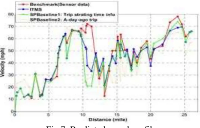
The SPNNS generates a map of the traffic speed at various time instances in the near future for every sensor along the route. The DTSP uses this map and generates the traffic speed profile along the route and a prediction of time needed to travel to any locations along the route from the origin. The predicted speed profile is shown below.
Fig.7. Predicted speed profile
After the time is estimated to reach the destination, available slot near destination is automatically allocated for user. Computational Optimized Allocation Algorithm is used to identify the specific allotment for parking individual vehicle. This is optimal, computationally efficient, Integer-bit power allocation algorithm. Using efficient lookup table searches and a Lagrange-multiplier bisection search, our algorithm converges faster to the optimal solution than existing techniques. Lagrange solutions, Integer-bit restriction, fast algorithm via table look up these are all the methods involved in computational optimized allocation algorithm.
The parking system displays the vacant parking area near the destination. Then user books the slot for parking the vehicle.
V.
ARCHITECTURE OF
INTELLIGENT PARKING
GUIDANCE
In this section architecture of the parking system is discussed. Create a basic frame work for Neural Network based parking via Google map guidance and get the users destination and parking information through Graphical User Interface. The parking slot design is done in the Google map. Google map displays the parking slot when user enters the source and destination.
An interface is developed which provides communication between the user and system. Intelligent Parking Information Guidance provides good interface with user. Configure Google API with developed neural network framework. Login page is designed enter the user name and password. Login ID can be used for both authentication and authorization
of user. The Login ID standard provides a framework for the communication that must take place between the identity provider and the user. New user enters name and password and login to the system to enter further details. A database is created using SQL Server to store and maintain the details of the user. New vehicle registration form is opened after the user login into the system. Then user enters the details such as vehicle ID, mobile number and Email id and register the details into the database. Database store all the details for further process. Then user selects the source and destination of their trip. Once the user specifies the source and destination, the map is generated which shows the path between origin and destination.
Then Intelligent Trip Modeling System is used to calculate the time taken between origin and destination. After the time is estimated to reach the destination, Intelligent Parking Information Guidance displays the available parking areas near the destination.
Fig.10. Flow Chart of Intelligent Parking Information Guidance system
VI.
CONCLUSION
We have presented an Intelligent Parking Information Guidance system provides an eminent Neural Network based intelligence system which provides automatic allocation of parking's through the Global Information system across the path of the users travel. This system also uses ITMS, developed to predict the speed profile from the origin to the destination of a given route.
The system contains two major components, namely, spot speed prediction (SPNNS) and trip speed profile prediction (DTSP). SPNNS algorithm is used to estimate the traffic rate in reaching the destination. DTSP algorithm is used to provide speed profile for the whole journey. These NNs were trained with historic traffic data to predict traffic speed at each traffic sensor location based on the dynamic traffic information available at the trip starting time. The proposed system is effective in slot allocation. Also this system reduces the traffic that occurs during parking. It helps the user informed about the available parking areas. The purpose of this project is to simulate and implement a real parking environment that allocates vacant parking slots using Allocation algorithm.
REFERENCES
[1] Jungme Park, Yi Lu Murphey, Ryan
McGee “Intelligent Trip Modeling for prediction of an origin-destination speed
profile” Ieee Transactions On
Intelligent Transportation Systems, Vol. 15, No. 3, June 2014.
[2] H. Dia, “An object-oriented neural network approach to short-term traffic forecasting,” Eur. J.Oper. Res., vol. 131, no. 2, pp. 253–261, Jun. 2001.
[3] G.-E. Katsargyri, I. V. Kolmanovsky, and J. Michelini, “Optimally con-trolling hybrid electric vehicles using path forecasting,” in Proc. Amer. Control Conf., St. Louis, MO, USA, Jun. 10–12, 2009, pp. 4613–4617.
[4] J. Park, D. Li, Y. Murphey, J. Kristinsson, R. McGee, M. Kuang, and T. Phillips, “Real time vehicle speed prediction using a neural network traffic model,” in Proc. IEEE IJCNN, 2011, pp. 2991–2996.
[5] Y. Bin, Y. Li, Q. Gong, and Z. Peng, “Multi-information integrated tripspecific optimal power management for plug-in hybrid electric vehicles,” in Proc. ACC, 2009, pp. 4607–4612.
[6] S. Jeon, S. Jo, Y. Park, and J. Lee, “Multi-mode driving control of aparallel hybrid electric vehicle using driving pattern recognition,” Trans. ASME, J. Dyn. Syst. Meas. Control, vol. 124, no. 1, pp. 141–149,Aug. 2000.
[7] M. Schulze and J. Z. Riveros, “Impact of electrical vehicles on strate-gic planning of energy infrastructure,” in Proc. Int. Conf. POWERCON, Oct. 24– 28, 2010, pp. 1–6.
[8] M. Lighthill and G. Whitham, “On kinematic waves II. A theory of traffic flow on long crowded roads,” Proc. R. Soc. Lond. A, Math. Phys. Sci.,vol. 229, no. 1178, pp. 317–345, May 1955.
[9] P. Richards, “Shock waves on the highway,” Oper. Res., vol. 4, no. 1, pp. 42–51, Feb. 1956.
[10] H. Payne, “Models of freeway traffic and control,” in Mathematical Models of Public Systems, G. A. Bekey, Ed. La Jolla, CA, USA: Simulation Councils, Inc., 1971, ser. Simulation Council Proceedings Series,pp. 51–61.
[11] I. Prigogine and F. C. Andrews, “A Boltzmann like approach for traffic flow,” Oper. Res, vol. 8, no. 6, pp. 789–797, Nov./Dec. 1960.
[13] D. Helbing, “Gas-kinetic derivation of Navier–Stokes-like traffic equa-tions,” Phys. Rev., vol. E53, no. 3, pp. 2266– 2381, Mar. 1996.
[14] D. Helbing and M. Treiber, “Gas -kinetic-based traffic model explaining observed hysteretic phase transition,” Phys. Rev. Lett., vol. 81, no. 14, pp. 3042–3045, Oct. 1998.
[15] A. Messmer and M. Papageorgiou, “METANET: A macroscopic simula-tion program for motorway networks,” Traffic Eng.Control, vol. 31, no. 9,pp. 466–470, Sep. 1990.
[16] V. P. Sisiopiku, N. M. Rouphail, and A. Santiago, “Analysis of correlationbetween arterial travel time and detector data from simulation and field studies,”Transp.Res. Rec., no. 1457, pp. 166–173, 1994.
[17] I. Okutani and Y. J. Stephanedes, “Dynamic prediction of traffic volume through Kalman filtering theory,”Transp. Res.B, vol. 18, no. 1, pp. 1–11,Feb. 1984. [18] L. Shen, “Freeway travel time estimation
and prediction using dynamic neural networks,” Ph.D. dissertation, Florida Int. Univ, Miami, FL, USA,2008.
[19] B. Williams and L. Hoel, “ and forecasting vehicle traffic flow as a seasonal ARIMA process: Theoretical basis and empirical results,” J. Transp. Eng., vol. 129, no. 6, pp. 664–672, Nov. 2003.
[20] W. Lam, Y. Tang, K. Chan, and M. Tam, “Short-term hourly traffic fore-casts using Hong Kong Annual Traffic Census,” Transportation, vol. 33, no. 3, pp. 291– 310, May 2006.
[21] J. You and T. Kim, “Empirical analysis of a travel-time forecasting model,” Geogr.Anal., vol. 39, no. 4, pp. 397–417, Oct. 2007.
[22] M. G. Cho, Y. Yu, and S. Kim, “The system for predicting the traffic flow with the real-time traffic information,” in Lecture Note in Computer Science. Berlin, Germany: Springer-Verlag, 2006, pp. 904–913.
[23] E. Lee, J. Kim, and W. Yoon, “Traffic speed prediction under weekday, time, and neighboring links’ speed: Back propagation neural network approach,” in Lecture Notes in Computer Science. Berlin, Germany: Springer-Verlag, 2007, pp. 626–635.
[24] T. Bellemans, B. De Schutter, and B. De Moor, “Models for traffic con-trol,” Journal A, vol. 43, no. 3/4, pp. 13–22,
2002.
[25] A. D. May, Traffic Flow Fundamentals. Englewood Cliffs, NJ, USA: Prentice-Hall, 1990.
[26] H. Liu, H. J. van Zuylen, H. V. Lint, Y. Chen, and K. Zhang, “Prediction of urban travel times with intersection delays,” in Proc. 8th Int. IEEE Conf. Intell. Transp. Syst., Vienna, Austria, Sep. 2005, pp. 402–407.
[27] V. Lint and J. W. C. Asd, “Reliable travel time prediction for freeways,” Ph.D dissertation, Civil Eng., Delft Univ. Technol., Delft, Netherland,2004.
[28] H. Suzuki, T. Nakatsuji, Y. Tanaboriboon, and K. Takahashi, “Dynamic estimation of origin– destination travel time and flow on a long freeway corridor,” J. Transp. Res. Board, vol. 1739, pp. 67–75, 2000.
[29] W. Zheng, D. H. Lee, and Q. Shi, “Short -term freeway traffic flow pre-diction: Bayesian combined neural network approach,” J. Transp. Eng.,vol. 132, no. 2, pp. 114–121, Feb. 2006.
[30] L. Vanajakshi and L. Rilett, “A comparison of the performance of artificial neural networks and support vector machines for the prediction of traffic speed,” in Proc. IEEE Intell. Veh. Symp., 2004, pp. 194–199.
[31] J. W. C. Van Lint, S. P. Hoogendoorn, and H. J. Van Zuylen, “Accu-rate freeway travel time prediction with state-space neural networks un-der missing
data,” Transp. Res. C, Emerging
Technol., vol. 13, no. 5/6, pp. 347–369, Oct.–Dec. 2005.
[32] J. W. C. van Lint, “Online learning solutions for freeway travel time prediction,” IEEE Trans. Intell. Transp. Syst., vol. 9, no. 1, pp. 38–47,Mar. 2008. [33] A. K. Sing and G. A. Lebdeh, “State-space