COMUNICAÇÕES OPORTUNÍSTICAS PARA
AQUISIÇÃO DE DADOS DE SENSORES
AMBIENTAIS USANDO UMA REDE VEICULAR
DIOGO MANUEL CASTRO GUIMARÃES
DISSERTAÇÃO DE MESTRADO APRESENTADA
À FACULDADE DE ENGENHARIA DA UNIVERSIDADE DO PORTO EM ÁREA CIENTÍFICA
FACULDADE DE ENGENHARIA DA UNIVERSIDADE DO PORTO
Departamento de Engenharia Electrotécnica e de Computadores
Comunicações oportunisticas para aquisição de
dados de sensores ambientais usando uma rede
veicular
Diogo Manuel Castro Guimarães
Dissertação em
Engenharia Electrotécnica e de Computadores
Dissertação realizada sob a supervisão de: Orientadora: Doutora Tânia Pinto Calçada
Co-Orientadora: Doutora Susana Sargento
Resumo
Esta dissertação foca-se no problema da transferência de grandes quanti-dades de dados recolhidos por sensores espalhados pela cidade do Porto para um servidor central. O principal objetivo é usar infra-estruturas existentes na cidade, como pontos de acesso WiFi e transportes públi-cos, tais como autocarros, taxis e camiões do lixo, para enviar dados de forma fiável, em vez de comunicações celulares, que se tornaria bas-tante caro. A análise ao estado da arte permitiu concluir que o uso de veículos como transporte de dados para recolher e transportar da-dos sem requisitos temporais é muito eficaz e consome poucos recursos. Na abordagem seguida pelo nosso trabalho os sensores ligam-se e en-viam dados oportunisticamente para os autocarros, que anunciam uma rede WiFi publica, e transportam-nos até encontrarem uma unidade fixa perto da estrada onde os descarregam. Esta unidade tem ligação à Internet e envia os dados para a cloud do UrbanSense. O trabalho desenvolvido nesta dissertação inclui uma arquitetura nova de software para os sensores e a cloud do UrbanSense, um mecanismo para permitir aos sensores escolherem entre usar um ponto de acesso WiFi ou a rede veicular para enviar dados, a possibilidade de abordar o envio de dados para os autocarros de duas maneiras diferentes e a realização de testes para confirmar o correto funcionamento do software e analisar o desem-penho do sistema. Os testes efetuados mostram que a solução proposta é capaz de enviar dados de forma fiável para a cloud do Urbansense através da rede veicular e que a percentagem de mensagens entregues ao servidor é aproximadamente 85 %. Esta dissertação apresenta todo o software desenvolvido e a architectura resultante do sistema.
Abstract
This dissertation addresses the problem of transferring large amounts of data gathered by sensors scattered through the city of Porto to a central server. The main focus is to use existing infrastructure in the city, in-cluding public WiFi hotspots and public transports, such as buses, taxis and garbage trucks to send data in a reliable manner, instead of using cellular communications, which would become expensive. An analysis to the state of the art allowed to conclude that the usage of vehicles as data mules to collect and transport data without timely requirements is very effective and has low resource consumption.
In the approach followed by our work the sensors opportunistically con-nect and send data to the buses, which announce a public WiFi network, and then transport it until they find a road side unit to offload it. The road side unit has connection to the Internet and relays the data to the UrbanSense cloud. The work developed in this dissertation includes a new software architecture for both the sensors and the UrbanSense cloud, a mechanism by which a sensor can choose if the data is sent through a WiFi hotspot or through the vehicular network, the possibil-ity of using two different approaches to send data to the buses, and the setup of tests to confirm the functioning of the developed software and analyze the performance of the system. The performed tests showed that the proposed solution is capable of reliably send data from sensors to the UrbanSense cloud through the vehicular network and has a de-livery ratio of messages of roughly 85 %. This dissertation covers the software modules created and the overall architecture of the resulting network.
Acknowledgments
I would like to start by thanking to Dra. Tânia Calçada, for inviting me to be a part of the Future Cities project, and give me the chance to contribute to it’s growing and development, as well as for all the help, council, availability and support provided which were essential for me to complete with success this dissertation.
I would also like to thank to Tiago Condeixa, João Azevedo, Rui Costa, Pedro Santos, Carlos Penichet, Yunior Luis and Dra. Susana Sargento who also contributed with their knowledge and expertise to the success of this work.
Finally, I thank the constant support and motivation of my girlfriend, family and close friends.
Diogo Manuel Castro Guimarães
“A wise man can learn more from a foolish question than a fool can learn from a wise answer.”
Bruce Lee
Contents
1 Introduction 1 1.1 Problem characterization . . . 1 1.1.1 Motivation . . . 1 1.1.2 Objectives . . . 2 1.1.3 Methodologies . . . 31.1.4 Contributions and Results . . . 4
1.2 Outline of the document . . . 5
2 Future Cities Project 7 2.1 Overview . . . 7 2.2 Vehicular Network . . . 8 2.3 UrbanSense Platform . . . 10 2.3.1 DCU architecture . . . 11 2.4 Data management . . . 12 2.4.1 Data Sender . . . 14 2.4.2 Asynchronous communications . . . 15 2.5 Network . . . 16
2.6 UrbanSense and Vehicular network integration . . . . 17
2.7 Summary . . . 19
3 State-of-the-Art 21 3.1 Delay Tolerant Networks . . . 21
3.1.1 Standardization . . . 22
3.1.2 Vehicular Delay Tolerant Networks . . . 23
3.1.3 Data Mulling . . . 24
3.2 Related Projects . . . 26
3.2.1 Routing Protocols in DTNs . . . 26
3.2.2 Data Mulling Implementations . . . 31
3.2.3 DTN Testbeds . . . 33 3.2.4 Sensor Platforms . . . 36 3.3 Summary . . . 37 4 Proposed Solution 39 4.1 Architecture overview . . . 40 4.2 Operation Modes . . . 41
4.2.1 DCU integrated in the DTN . . . 42 ix
x CONTENTS
4.2.2 CoAP data transmission . . . 43
4.2.3 Interaction with the Server . . . 44
4.3 Implementation . . . 45
4.3.1 Sending data to the DTN . . . 45
4.3.2 Acknowledge bundles with VeniamDTN . . . . 47
4.3.3 Integration with Twisted . . . 48
4.4 Summary . . . 50
5 Tests and Results 51 5.1 Lab tests . . . 51
5.1.1 DCU in the DTN . . . 52
5.1.2 CoAP data transmission . . . 53
5.2 Urban scale testing . . . 53
5.2.1 First Link Testing . . . 54
5.2.2 Urban Testbed without UrbanSense Cloud . . 56
5.2.3 Urban Testbed with UrbanSense Cloud . . . . 61
5.3 Summary . . . 64
6 Conclusions and Future Work 65 6.1 Conclusions . . . 65
6.2 Future Work . . . 67
A Experimental Characterization of V2I WiFi
Connec-tions in an Urban Testbed 69
B Poster for EWSN Conference 73
List of Figures
2.1 RSU . . . 9
2.2 OBU . . . 9
2.3 Diagram of the architecture of the system. . . 10
2.4 Deployed DCU. . . 11
2.5 DCU components. . . 12
2.6 DCU software architecture. . . 13
2.7 UrbanSense server architecture. . . 13
2.8 Message sequence of the Data Sender protocol. . . 14
2.9 Structure of a bundle message. . . 15
2.10 Structure of an acknowledgment sent by the server. . 16
2.11 Network topology. . . 17
2.12 Previous work proposed architecture. . . 18
3.1 Comparison between DTN and OSI architectures. . . 23
3.2 Proposed layered architecture for VDTNs. . . 24
3.3 Three layers architecture of data mulling. . . 26
4.1 Implemented architectures. . . 40
4.2 Software architecture in a DCU when it runs Veni-amDTN. . . 43
4.3 DCU final architecture. . . 44
4.4 DCUs interacting with the server. . . 45
4.5 Flow chart of the DataSenderProtocol. . . 46
4.6 Acknowledgments in the DTN. . . 47
4.7 Implemented architectures. . . 48
5.1 Setup used for small scale testing. . . 52
5.2 Path taken by the vehicle with the OBU. . . 55
5.3 First link test results. . . 55
5.4 Urban scale DCU results . . . 58
5.5 Urban scale DTN results. . . 59
5.6 Bundle replication. . . 60
5.7 Contact durations. . . 62
5.8 Sent and Acknowledged bundles. . . 62
5.9 Delay since sample creation to it’s arrival. . . 63
5.10 Collected temperature data. . . 64 xi
Abbreviations
DCU Data Collecting Unit DTN Delay Tolerant Network OBU On Board Unit
RSU Road Side Unit
WSNs Wireless Sensor Networks
CoAP Constrained Application Protocol
STCP Sociedade de Transportes Coletivos do Porto EWSN European Wireless Sensor Networks
VDTN Vehicular Delay Tolerant Networks M2M Mobile to Mobile
V2V Vehicle to Vehicle
V2I Vehicle to Infrastructure GPS Global Positioning System
IEEE Institute of Electrical and Electronics Engineers TCP Transmissions Control Protocol
UDP User Datagram Protocol SSID Service Set Identifier
VLAN Virtual Local Area Network IP Internet Protocol
WAN Wide Area Network
AODV On Demand Distance Vector VANET Vehicular Ad-Hoc Network R2R RSU to RSU
AUV Autonomous Underwater Vehicle USN Underwater Sensor Networks ARQ Automatic Repeat reQuest ADT Adaptive Data Transfer GPRS General Packet Radio Service WWBAN Wireless Body Area Network API Application Programming Interface DHCP Dynamic host Configuration Protocol
Chapter 1
Introduction
1.1
Problem characterization
1.1.1
Motivation
A critical step towards smarter and safer cities is to endow them with the ability to gather a wide variety of data sets for decision support tools and applications [1]. A challenge to this step is the creation of a low-cost infrastructure to gather the massive amount of data from sensors in the city, people and vehicles, to be provided in cities platforms. A possible solution is to use vehicles as data mules for data collected by sensors delivering it to the vehicles op-portunistically. Although several real platforms based on vehicular communications have been developed [2, 3, 4, 5], they mostly run with WiFi (low transmission range) and cellular communications (high cost). A viable solution is to use Delay Tolerant Networks.
Delay-Tolerant Networks (DTNs) are gaining relevance due to their ability to allow a whole new array of applications to emerge. They can be used to allow communications in networks where there is lack of end-to-end connectivity, high latency, high error rates, which is very common in zones affected by natural disasters, in Wireless Sensors Networks (WSNs), in networks with high node mobility and in networks with nodes with low range, for example. DTN can, however, use the mobility existent in the environment,
2 Introduction
for instance in vehicles, pedestrians or even animals to collect and transport data.
Vehicular DTNs are DTNs where vehicles communicate with each other and with fixed nodes in order to disseminate, obtain and share information. This can lead to usages such as notification of traffic information, accident warnings, weather conditions, advertisements, mechanisms to avoid vehicle collisions, Internet access to vehicles, and multimedia sharing. A vehicle can even gather information about the environment around it.
There are three main components in the Future Cities project, the BusNet, the UrbanSense platform and the UrbanSense cloud. The BusNet is an urban-scale vehicular network with 600 nodes such as buses, trucks and road-side units, all communicating through IEEE 802.11p vehicular technology. The UrbanSense platform is a network of Data Collecting Units (DCUs) with 75 nodes. In the city there are also several WiFi hotspots so that a DCU can either connect to a passing bus or to the hotspot. The UrbanSense cloud is the destination of all data and is responsible for sharing the stored information with the city. Following the validation of [6] on using public transportation as data mules, a proof of concept to use ve-hicles to collect data from DCUs was developed in [7]. The data collected is then offloaded to Road Side Units (RSUs) with Internet connection, which relay the data to the UrbanSense cloud. This work is continued in this dissertation, where in a first stage the us-age of the BusNet to collect data from UrbanSense has been tested with a single sensor deployed along a bus route [8]. However, several challenges need to be addressed to evolve our network to efficiently gather data in a smart city, through a delay-tolerant approach.
1.1.2
Objectives
This work is part of the FutureCities project which has the main objective of deploying an urban scale data muling system that uses nodes of the vehicular network, BusNet, existing in Porto’s public transports to collect data from DCUs scattered through the city and send it to the UrbanSense cloud. The main challenges to overcome
1.1 Problem characterization 3
are 3: (1) Each DCU must be able to either send data through the DTN or directly to the server through a WiFi hotspot. The WiFi connection is also important to access the DCUs through SSH con-nections to change configurations or to solve occasional problems with its functioning. (2) Defining and implementing a light and effi-cient software architecture for the DCUs in order to allow the usage of the DTN in large scale, using DTN routing software developed by third-parties. (3) Defining the metrics to evaluate the perfor-mance of the implemented solution, and obtain the corresponding results. The chosen metrics used to evaluate the performance of the DTN are the number of packets sent in each contact between an On Board Unit (OBU) and a DCU, the number of packets that effec-tively reached the OBU, the duration of each contact, the number of packets lost in the DTN and the delay between the instant data is gathered and the instant it reaches the UrbanSense cloud.
1.1.3
Methodologies
This dissertation extends the work started in [7] where a data mulling proof-of-concept was developed to use vehicles to collect data from fixed sensors and deliver them to the cloud through RSUs connected to the municipal fiber optical network. The work in [7] was based on an existent DTN open-source implementation DTN [9]. IBR-DTN has no support for node resource management, nor oppor-tunistic routing optimized for vehicular networks and caused mem-ory problems in the existing nodes of the network. To overcome this problem we propose to use VeniamDTN, an alternative DTN implementation developed by partners of the Future Cities project, which is lighter and has better performance. There are two modes to integrate VeniamDTN. The first is to install it in the DCUs ex-tending the DTN up to the sensors. In the second mode, the DTN is confined to the vehicular network and the DCUs interact with the mules through CoAP [10], a communications protocol designed to run on resource limited devices. To interact with this DTN im-plementation, in both modes, adaptations to the DCU software ar-chitecture were designed and developed. A new software module
4 Introduction
was introduced and adaptations to existent DCU modules were also required. The first mode was implemented and demonstrated in a small scale setup in EWSN conference, 12th European Conference
on Wireless Sensor Networks (EWSN 2015), February 2015, Porto,
and is accepted to be presented at MOBICOM. The second mode is used in a large scale experiment in the city. The first mode of using VeniamDTN had the disadvantage of duplicating some of the functions that were already implemented, such as detecting when an OBU is near and storing the messages waiting to be sent, while there is no OBU nearby. The second mode has the advantage of not having to run on the DCUs. Since the new version brings several advantages, it was the one used in the urban scale implementation.
1.1.4
Contributions and Results
The development of this work allowed the deployment of an urban-scale testbed using several DCUs, STCP buses and RSUs to collect and store environmental data from the city of Porto. The DCUs have mechanisms to choose between using the vehicular network or an WiFi hotspot to send data. The option to include the DCUs in the Delay Tolerant Network is also available. This testbed will not only allow for a better understanding of DTNs and their function-ing, but also will give the opportunity to study the data collected and gather diverse information about the city, and use this infor-mation to improve the citizens quality of life. The tests done in this work allowed to conclude that the main factor that influences the contact time between a DCU and an OBU is the traffic. The number of messages sent in each contact depends on the duration of each contact and on the time elapsed between contacts, since the longer the time between them more samples are collected. It was also possible to see that the average delay since a sample is gathered until it reaches the server is roughly 2 hours and that there was a de-livery rate of messages to the server of 85%. These results show that the proposed solution offers a reliable way of sending data without time restrictions. This work also contributed to a demonstration in the 12th European Conference on Wireless Sensor Networks (EWSN
1.2 Outline of the document 5
[8] which is included in Appendix A. The poster presented in the conference is included in Appendix B.
1.2
Outline of the document
This dissertation is organized in 6 chapters. This chapter contextu-alizes this work and shows why it’s relevant. Chapter 2 presents and describes the Future Cities project, gives an overview of what has been done before the beginning of this work and it’s main character-istics. Chapter 3 presents the fundamental concepts and the state of the art on Delay Tolerant Networks and Vehicular Delay Toler-ant Networks, Data Mulling, and presents some deployed testbeds which use data mulling and apply the concept of Delay Tolerant Networks. Chapter 4 presents a detailed description of all the work developed in this dissertation, and explains what was added to the previous work developed in the Future Cities project. Chapter 5 de-scribes all tests performed as well as the obtained results. Chapter 6 resumes all the work done and the fundamental points discussed in this work. It also suggests some aspects to focus in some future work.
Chapter 2
Future Cities Project
This chapter presents the Future Cities project where the current work is contextualized. The deployed platforms are described, in-cluding the crowdsensing application, the vehicular network and the UrbanSense platform. The main components of the vehicular network are described as well as the way it works. Then the Ur-banSense platform is detailed, including the software and hardware architecture of the Data Collecting Units. The overall architecture of the network topology present in Porto is also described. Finally, the work which serves as a starting point for this dissertation is described to allow a better understanding of the contributions this dissertation added to the Future Cities project.
2.1
Overview
The goal of the Future Cities project is to turn the city of Porto into an urban-scale living-lab, allowing researchers and companies to make and improve the quality of their studies, and minding the results, develop products to improve the citizens’ life quality. To achieve this goal, multi disciplinary work is required involving mul-tiple fields of engineering, computer science, psychology and human sciences. To this point there are three main platforms implemented: a crowdsensing application, a vehicular network and the UrbanSense platform. The latter two will be the main focus of this dissertation.
8 Future Cities Project
The crowdsensing application, SenseMyCity, runs on Android smart-phones to acquire data from its external and internal sensors. Data is then sent to a server in the cloud for analysis and processing. An example of an external sensor is the use of a vital jacket that measures the ECG levels of the user.
The vehicular network is currently spread over 600 vehicles includ-ing buses, taxis and garbage trucks. In each vehicle there is an On-Board-Unit (OBU) able to communicate directly with other OBUs and with Road-Side-Units (RSU) through 802.11p [11] forming the largest Vehicle-to-Vehicle (V2V) network in the world. Road-Side-Units (RSU) are fixed gateways to the Internet and have a 802.11p interface and a connection to the optical-fiber municipal network. OBUs are also mobile WiFi hotspots being used by people and other devices on-board the vehicles, on side walks or in the roads. This is possible through the usage of the 802.11n interface of the OBU. The UrbanSense platform is a large-scale infrastructure for local monitoring. UrbanSense includes 75 Data Collecting Units (DCUs) spread through the city of Porto and a server in the cloud responsible for storing and processing the data. These DCUs are able to gather information about the air quality, noise, meteorology, GPS coordi-nates, Carbone Monoxide, Carbone Dioxide and Nitrogen Dioxide levels, and count pedestrians in a given place using image captured by a video camera. The information obtained with this data can help to identify problems in certain city areas and lead to possible inter-ventions, improve city planning and environmental management.
2.2
Vehicular Network
The main components of the vehicular network are the OBUs, in-stalled on the STCP buses, taxis and garbage trucks, and the RSUs placed near the side of the roads which provide access to the In-ternet for the vehicular network. Currently the vehicular network counts with 600 vehicles including STCP buses, waste management vehicles and taxis, and with 57 access points or RSUs and is being managed by a private company, VeniamWorks, that is part of the
2.2 Vehicular Network 9
Future Cities project consortium. RSUs are connected to the city’s network infrastructure with fiber links.
The available interfaces in the OBUs are IEEE 802.11n, IEEE 802.11p, and cellular (4G). The OBU uses 802.11n to broadcast the network ”STCP | PortoDigital” to which it’s possible to connect to, to gain access to the Internet. IEEE 802.11p is used to communicate with other OBUs and with RSUs. The cellular interface of the OBUs is used when RSUs are not available in order to provide a stable Internet connection to the users on the bus. The OBUs also have a GPS to obtain the position of the vehicle and other localization purposes. The RSUs have an optical-fiber connection to the Inter-net. In figure 2.1 it’s represented a real implementation of a RSU while figure 2.2 depicts and OBU.
Figure 2.1: RSU Figure 2.2: OBU
The vehicular network has to deliver a large amount of data to the UrbanSense cloud. In order to do so, the mobile nodes of the vehicular network apply the store and forward paradigm where they store collected data and, when possible, forward information to the RSUs. This mechanism is standardized and is known as the Delay Tolerant Network (DTN) [12, 13] paradigm. The software responsi-ble for the routing and controlling all data transmission between all DTN elements is VeniamDTN. There is the possibility of using it in two modes, one that has the DTN extending to the sensors and the other which restrains the DTN to the vehicular network. The first mode has to run VeniamDTN in the sensors while he other mode uses CoAP [10] to communicate with the OBUs. CoAP is a software protocol aimed to be used in very simple electronic devices
10 Future Cities Project
that allows them to communicate interactively over the Internet. It is particularly targeted for small low power sensors, switches, valves and similar components that need to be controlled or supervised remotely, through standard Internet networks. This has the advan-tage of not having to run extra software on the sensors thus requiring less processing.
2.3
UrbanSense Platform
The architecture of the UrbanSense platform was designed with both simplicity and flexibility in mind. The main components are sketched in figure 2.3.
Figure 2.3: Diagram of the architecture of the system.
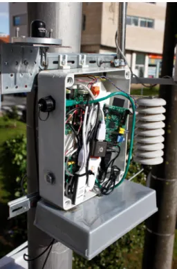
Data is gathered either by fixed Data Collecting Units (DCUs) located at carefully selected locations throughout the city or, by mobile DCUs, located on top of buses that are also part of the vehicular network. When data is collected, it is initially stored in a database running locally on the sensor node. Figure 2.4 shows a real implementation of a DCU.
2.3 UrbanSense Platform 11
Figure 2.4: Deployed DCU.
The use of the local database was motivated by the need to provide consistent and robust persistent storage for the collected data during periods of lack of connectivity. This design has the added advantage of turning the data storage very robust to power cuts and similar incidents. All the collected data is stored in this database while there is no opportunity to upload it to the central database.
Data transport towards storage may be performed by taking advantage either of static public WiFi hotspots provided by Porto Digital, using an Ethernet connection or using OBUs from the ve-hicular network as data mules. In the case of static public WiFi hotspots, nodes tend to be connected permanently to the cloud for exchanging data or for remote management operations. To be able to use the BusNet hotspots, nodes opportunistically connect to a nearby WiFi network provided by the OBU of a passing bus. The latter is the result of the work developed in this dissertation.
2.3.1
DCU architecture
12 Future Cities Project
Figure 2.5: DCU components.
In the figure it’s possible to see that a DCU has three main com-ponents: a sensor board, a control board and a Raspberry Pi. The sensor board contains the environmental sensors and the most basic support circuitry. It’s placed outside of the DCU box and placed inside an appropriate enclosure in a location where the magnitudes to measure are in contact with the sensors. The available sensors are temperature, precipitation, wind speed, wind direction, lumi-nosity, noise, solar radiation, particles, CO, N O, N O2 and CO2.
The control board is in charge of interacting with the actual sensing devices. The Raspberry Pi is in charge of all communications, data storage, interfacing with the control board and with the WiFi cards. In the figure it is possible to see two WiFi cards, one to connect to the DTN and another to connect to a WiFi hotspot.
2.4
Data management
The software architecture of a DCU is portrayed in figure 2.6. The figure shows that the software architecture of the DCU has four main components: (1) the Data Collector, which is in charge of scheduling the polling to each sensor in order to obtain measurement values; (2) a local database, where the sensor samples and the pending messages are stored; (3) the Connection Manager which controls how data is transmitted; and (4) the Data Sender with the function of sending the data stored in the local database to the UrbanSense server, and managing the local database.
2.4 Data management 13
Figure 2.6: DCU software architecture.
The UrbanSense cloud server is in charge of storing data in the central database; its software architecture is displayed in figure 2.7.
Figure 2.7: UrbanSense server architecture.
The server software architecture has two main components: (1) a service that accepts TCP or UDP connections to receive data from
14 Future Cities Project
sensors and store it in the central database; and (2) the database used to store the data permanently.
2.4.1
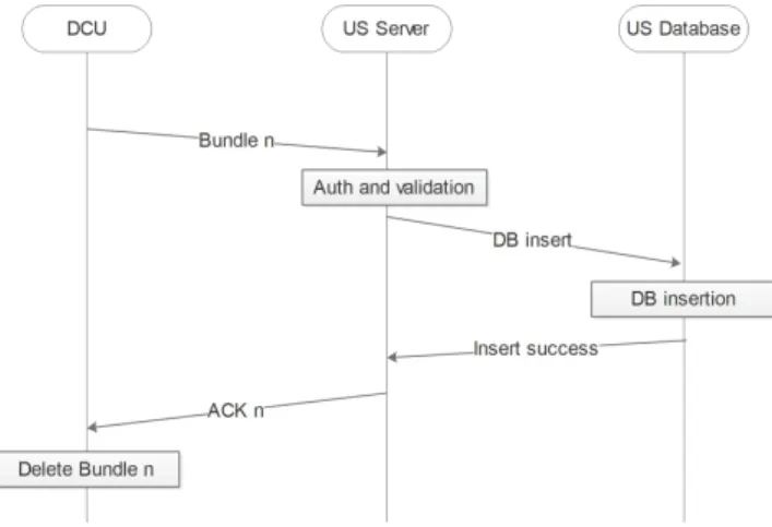
Data Sender
The Data Sender is in charge of sending the data present in the DCUs local database to the central database. For that it communi-cates with a service running in the server, which authenticommuni-cates and validates the data before accepting any data into the database. After the data has been successfully stored, an acknowledgment message is returned to the Data Sender running in the origin DCU. Once it receives this message the Data Sender can delete the corresponding messages from its database. This process is illustrated in figure 2.8.
Figure 2.8: Message sequence of the Data Sender protocol.
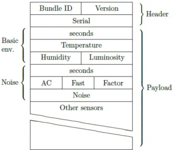
This process involves two types of messages, the Bundle mes-sages and the Acknowledgment mesmes-sages. The Bundle mesmes-sages contain the data intended to send to the UrbanSense cloud while the Acknowledgments confirm the reception of the data. Figure 2.9 contains the structure of the bundle messages, while figure 2.10 rep-resents the acknowledgments.
To form the bundle messages the Data Sender checks every table of the DCU’s database, and adds an entry from every table with data in it. For instance, in figure 2.9 it’s present data from the “Basic Environment” and “Noise tables”.
2.4 Data management 15
Figure 2.9: Structure of a bundle message.
2.4.2
Asynchronous communications
The Data Sender and Data Collector modules mentioned earlier used the Twisted framework [14]. Twisted is an event-driven networking engine written in Python and licensed under the open source MIT li-cense. It’s based on the event-driven programming paradigm, mean-ing that it’s possible to write short callbacks which are called by the framework. It’s a very powerful tool to handle asynchronous tasks. This tool is designed for complete separation between logical proto-cols and physical transport layers. The connection between a logical protocol and a transport layer happens at the last possible moment. The logical protocol is informed of the transport layer instance and can use it to send messages.
A major concept of Twisted is the deferred. A deferred is an in-stance of a class designed to receive and process a result which has not been computed yet. They can be passed around, but cannot be asked for their value. Each deferred supports a callback chain. When the deferred gets the value, it is passed to the functions on the callback chain, with the result of each callback becoming the input for the next. Deferreds make it possible to arrange to operate on the result of a function call before its value has become available. Another major concept is the reactor. The reactor is the core of
16 Future Cities Project
Figure 2.10: Structure of an acknowledgment sent by the server.
the event loop within Twisted. The event loop is a programming construct that waits for and dispatches events or messages in a pro-gram. The reactor provides basic interfaces to a number of services, including network communications, threading, and event dispatch-ing.
In Twisted there is also an important class which is the factory. The factory is a Twisted object that creates an instance of the communi-cations protocol when the connections are made, and decides what to do when the connection is lost or when an attempt to connect fails.
In our modules Twisted is used to implement all communication tasks. This includes the Data Collector communication with the control board and all the Internet based communications in the Data Sender. The most relevant component of the Data Sender module is the DataSenderProtocol class. This class implements the communication protocol that is discussed in section 2.4.1. Because it is a class intended to implement a protocol, it inherits directly from the Protocol class defined by twisted.
2.5
Network
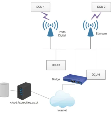
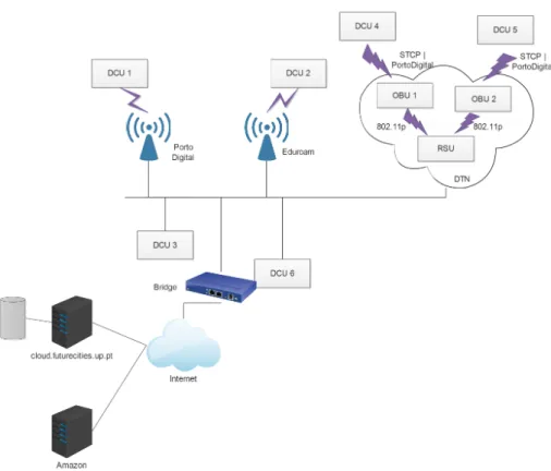
The DCUs can send data to the UrbanSense server through two different ways, using Ethernet or public WiFi hotspots. The network topology used to make this possible is present in figure 2.11.
Currently a DCU has the option to connect through public WiFi hotspots provided by Universidade do Porto and Associação Porto Digital. Besides the existing "Eduroam" and "WifiPortoDigital" SSIDs, the hotspots in Universidade do Porto and Associação Porto Digital, also have configured the non broadcasted SSID "PortoLiv-ingLab" which is used by DCUs. Traffic exchanged through the SSID "PortoLivingLab" is switched in a VLAN (Virtual LAN) that
2.6 UrbanSense and Vehicular network integration 17
Figure 2.11: Network topology.
spans the Universidade do Porto and Porto Digital Networks. The "bridge" server hosted at FEUP is the default gateway of this VLAN and routes its traffic to the Internet.
In the UrbanSense cloud there is the server, responsible for receiv-ing data from the DCUs and storreceiv-ing it in the cloud database. In the case where a DCU uses a hotspot, it sets a TCP connection directly with the UrbanSense cloud and data is exchanged directly between both parts. The DCU sends sensor’s data and the server, after storing it in the database sends back the acknowledgments.
2.6
UrbanSense and Vehicular network
integration
In [7] a proof-of-concept was developed to use vehicles to collect data from DCUs and carry it until it reaches an RSU which, through the connections it has to the municipal fiber optical network, delivers the data to the UrbanSense server. The Authors propose the archi-tecture in figure 2.12. When a DCU detects an OBU, it sends the data stored in its local database. The OBU carries and stores this
18 Future Cities Project
data and later delivers it to a RSU. This process is known as data-mulling. The RSU forwards the data to the UrbanSense server that extracts, processes, stores and acknowledges the information. The Acknowledgments are then sent back to the original DCU. When a DCU receives an Acknowledgment confirming the reception and storage of a sample, it deletes the respective sample from its local database.
OnBoardUnit
802.11p
3G
Road Side Unit Sense Unit
802.11p Optic Fiber
Future Cities Server and Database
Figure 2.12: Previous work proposed architecture.
For the routing and communication between the DTN nodes this work used an open-source implementation IBR-DTN [9], which has no support for node resource management, nor opportunistic rout-ing optimized for vehicular networks and caused memory problems in the existing nodes of the network.
Currently, the partners operating the vehicular network have the proprietary VeniamDTN implementation running in the network. The VeniamDTN implementation is lighter and faster, and solves the performance issues of IBR-DTN by reducing the OBU’s mem-ory, communication and processing demands. The performance im-provements have been made at the expense of giving away some functionalities such as the support for bidirectional communications which were supported in [9]. In order to use the VeniamDTN soft-ware, a new software architecture is required, for both the DCUs
2.7 Summary 19
and the server. In the current thesis, we design, implement, deploy and test the required interface.
2.7
Summary
This chapter is a summary of the project before the contributions added in this dissertation. It describes in a few topics the current solution and it gives insight on the main components of the project. The vehicular network, the UrbanSense platform and the DCU ar-chitecture are described in more detail because they are the areas with more relevance to this dissertation.
Chapter 3
State-of-the-Art
In this chapter the fundamental concepts used in this dissertation and in the practical work are introduced, such as Delay Tolerant Networks (DTN), Vehicular Delay Tolerant Networks (VDTN), and Data Mulling, along with insights on work done in these areas. Delay Tolerant Networks gained relevance due to their potential capabil-ity of transmitting data in conditions where end-to-end connection is not guaranteed. They can be extremely useful in disseminating safety information in VDTNs [15, 16], in wireless sensor networks, in providing Internet connectivity to remote locations [17, 18] and pro-viding a mean for communications for rescue teams in catastrophe scenarios [19]. Data Mulling is a solution to implement a store-carry-and-forward mechanism that allows a mobile node to carry data when it has no neighbor nodes and upload it to the destination on another node with better connection conditions. This chapter ends with the exposure of several testbeds already implemented, and how they compare to the work developed in this dissertation.
3.1
Delay Tolerant Networks
DTNs are networks which appear to deal with scenarios unable to provide end-to-end connectivity, due to the constant connection breaks between its nodes, caused by their movement, harsh environ-mental conditions, physical obstacles or limited range transmission.
22 State-of-the-Art
This kind of topology is usually used in extreme environments such as underwater networks, interplanetary networks, sparse wireless sensor networks, people networks, military tactical networks, tran-sient networks and vehicular networks. The network should be able to transport information from the source to the destination, even if this process takes hours. DTN routing protocols take advantage of temporal paths created in the network as nodes encounter their neighbors and exchange messages they have been asked to forward. There are several approaches to deal with the connection problems in DTNs that depend on use cases such as Data Mulling and Ve-hicular Delay Tolerant Networks (VDTN). VDTNs take advantage of the mobility of vehicles to disseminate data between nodes, while applying the same paradigm. Data mulling is the process of obtain-ing information from a node, fixed or mobile, and carryobtain-ing it until it’s possible to deliver the information to the destination, thus the vehicle is functioning as a data mule.
3.1.1
Standardization
As seen above, in DTNs loss of connection, extreme delays, lack of an end-to-end connection, low transmission reliability are issues very present, and currently there is a lot of research being made to cope with these issues, in fact the DTN Research Group proposed an architecture [12] and a communication protocol for DTNs [13]. The work in [12] defines a “bundle layer”, an end-to-end message-oriented overlay placed above the transport layer. Every node inte-grating the DTN runs this new layer. The function of the bundle layer is to provide persistent storage to combat lack of connectivity. The DTN architecture can be seen in figure 3.1. The stack in the left is the standard OSI architecture, while the right is the one pro-posed in [12] by the DTN Research Group.
The bundle layer is responsible for aggregating data from the application into bundles, which are the protocol data units for this layer. Bundles are defined as the protocol data unit at the DTN bun-dle layer, and represent aggregates of packets with common charac-teristics, such as the same destination node. It also includes a
hop-3.1 Delay Tolerant Networks 23
Figure 3.1: Comparison between DTN and OSI architectures.
by-hop transfer of reliable delivery responsibility (custody transfer) and an optional end-to-end acknowledgment (return receipt). It also uses a flexible naming scheme based on Uniform Resource Identi-fiers [20] capable of encapsulating different naming and addressing schemes in the same overall naming syntax.
3.1.2
Vehicular Delay Tolerant Networks
VDTNs are DTNs that use vehicles to disseminate bundles through the network. The vehicles can be the origin node, the destination node or used to relay bundles. These networks have special char-acteristics such as: predictable mobility, because movements are not random since vehicles have to stay on the road; high mobility, the network topology changes rapidly because of vehicle speed and the network topology evolves depending on time and location; large scale since all vehicles are potential nodes; partitioned networks, since the communication range is limited; no significant power of computation constraints since a vehicle can generate sufficient power [21].
The mobility of the vehicles is used to collect bundles from fixed nodes and carry them to the destination. If necessary the mobile nodes can interact with each other to achieve a better performance. In scenarios where there is a low density of mobile nodes, it’s pos-sible to use relay nodes, with store-and-forward capabilities where vehicles can obtain or deposit information. These networks can be used to carry emergency and traffic information between vehicles [22].
24 State-of-the-Art
In [23] a layered architecture for the implementation of VDTN is proposed. The main characteristic of this proposal is that separates the data plane from the control plane. This means that, when two nodes connect, control information is exchanged in order to adjust the connection characteristics to support the appropriate transmis-sion and reception of data, thus improving the performance of the network. In contrast with the regular DTN layered architecture, it’s proposed that the bundle layer instead of being on top of the trans-port layer, is placed below the network layer, like in the figure 3.2.
Figure 3.2: Proposed layered architecture for VDTNs.
Since the components needed for the VDTN to work are in the two bottom layers, it can lead to a faster processing of protocol data units. Also, it allows that in cases where mobile nodes only forward bundles, only the bottom layers can be implemented, thus increas-ing the speed at which the bundles are processed and transmitted. Another advantage is that it’s possible to aggregate IP packets with the same destination into a bundle. It’s also proposed alternatives to bundle aggregation such as combining packets from the same ap-plication or with the same QoS. With security in mind, the necessity of nodes authentication is also emphasized. The BusNet, however, implements the standard DTN implementation because this archi-tecture has not been yet tested.
3.1.3
Data Mulling
Nowadays, sensor networks have an incredibly wide set of potential usages. Typically, sensors are deployed over a large geographical
3.1 Delay Tolerant Networks 25
area and form a dense ad-hoc network where multi-hop communi-cation is used to send data to a gateway. However, there are situa-tions where fine-grain sensing is not needed, and therefore, a sparse sensor network would be enough, such is the case with environmen-tal monitoring. This allows reducing costs because less equipments are used. When compared to other categories of wireless networks, wireless sensor networks possess two fundamental characteristics: multi-hop transmission and constrained energy sources. First, since sensor nodes have limited transmission ranges and organize them-selves in an ad hoc fashion, two wireless sensor nodes that cannot reach each other directly rely on other sensor nodes to relay data between them. In general, data packets from the source node need to traverse multiple hops before they reach the destination. Second, since sensors are usually small and inexpensive, they are assumed to have constrained energy sources, and any protocols to be deployed in sensor networks need to be aware of energy usage [24].
The monitored area could be far away from the nearest gate-way. When the distance between sensors and gateways becomes too big, communication between them becomes impossible. This is the perfect scenario for the utilization of data mules, where a mobile component of the network called mule collects information from the sensors and carries it until it reaches a gateway. A mule can differ from scenario to scenario, in a city traffic monitoring ap-plication vehicles can act as mules, in a habitat monitoring scenario the role can be served by animals, and in a park monitoring scenario people can be mules. To improve system performance mules can ex-change data with each other, allowing a multi-hop mule network to be formed, thereby reducing the latency times on the mules and in-creasing overall reliability from replication of data. Usually the data mulling architecture consists of three layers: a bottom layer made of fixed or mobile wireless sensor nodes, a middle layer of mobile transport agents (mules) and a top tier of WAN connected devices [25, 26, 24]. Figure 3.3 illustrates the data mulling architecture.
This architecture is also scalable as deployment of new sensors or mules requires no network configuration. Also, since sensors only rely on mules to transmit data and mules are interchangeable, the
26 State-of-the-Art
Figure 3.3: Three layers architecture of data mulling.
failure of any number of mules does not mean connectivity failure. It’s important to refer that no sensor depends on any individual mule, hence failure of any particular mule does not disconnect the sensor from the sparse network. Although a failure of a mule does not cause lack of connectivity, the primary effect of a mule failure on the overall system is a slight increase in latency as there are now fewer mules to pick up data. Usually, in this kind of networks, energy consumption of the sensors is a concern, as explained in [25] and [27], so the mule discovery and the data transfer processes must be energy efficient [24], in order to prolong the lifetime of the sensors. In this kind of network topologies, where data mulling is implemented, unlike the architectures mentioned in the previous sections, there are always mobile nodes that have the function to carry data. In the DTN and VDTN architectures there is the concern to make the network deal with connection loss in the best way possible.
3.2
Related Projects
3.2.1
Routing Protocols in DTNs
Currently there are several proposals for routing and application protocols to implement DTNs such as [28, 29, 30, 31, 32, 33]. DTN routing protocols can be classified as either forwarding-based [30, 31] or replication-based [29, 32, 33]. Forwarding-based protocols keep a copy of a message in the network and attempt to forward that copy
3.2 Related Projects 27
toward the destination at each encounter. In contrast, replication-based protocols insert multiple copies, or replicas, of a message into the network to increase the probability of message delivery. Many of these protocols trade overhead and computational complexity for increased successful delivery. Since there are no guarantees that a route will ever be available, many current DTN routing protocols ap-ply epidemic-style techniques, leveraging the fact that an increased number of copies of a particular message in the network should im-prove the probability that the message will reach its intended desti-nation. However, such techniques come at a high price in terms of network resources, resulting in the rapid deletion of buffer space and energy on resource-limited devices, the rapid depletion of available bandwidth, and the potential to greatly increase end-to-end delay.
Many DTN protocols make routing and forwarding decisions based on advertised contact information, allowing for denial-of-service attacks over the already intermittently connected network. The work in [28] tries to avoid some of these issues by taking advantage of the fact that in environments targeted by DTNs, such as disaster scenarios and certain vehicular networks, different classes of nodes naturally tend to have more node encounters than others. It uses an encounter-based metric for optimization of message passing that maximizes message delivery ratio while minimizing overhead, both in terms of extra traffic injected into the network and control over-head, as well as minimizing latency as a second order metric.
The protocol proposed in [29] optimizes a specific routing metric, such as the worst-case delivery delay or the fraction of packets that are delivered within a deadline. The key insight is to treat DTN routing as a resource allocation problem that translates the routing metric into per-packet utilities, which determine how packets should be replicated in the system. This protocol was evaluated through a prototype deployed over a VDTN testbed of 40 buses and simula-tions based on real traces.
The routing in [30] is based on prioritizing both the schedule of packets transmitted to other peers and the schedule of packets to be dropped. These priorities are based on the path likelihoods to
28 State-of-the-Art
peers according to historical data and also on several complemen-tary mechanisms, including acknowledgments, a head-start for new packets, and lists of previous intermediaries. This work was tested in a DTN deployed in 30 buses.
A protocol that uses a probabilistic metric called delivery pre-dictability, PRoPHET is proposed in [31], and is established at each node for each known destination indicating the predicted chance of that node delivering a message to that destination. When a node encounters another node, they exchange information about the de-livery predictabilities they have and update their own information accordingly. Based on the delivery predictabilities, a decision is then made on whether or not to forward a certain message to this node. However, this work is only theoretical and was not simulated nor tested.
In [32] a routing protocol is described, and it prioritizes bun-dles based on costs to destination, source, and expiry time. Costs are derived from per-link “average availability” information that is disseminated in an epidemic manner. This maintains a gradient of replication density that decreases with increasing distance from the destination, and simulations show that it outperforms AODV, a routing protocol for Ad-Hoc networks.
A protocol called Spray and Wait was developed in [33] that “sprays” a number of copies into the network, and then “waits” until one of these nodes meets the destination. Through theory and simulations, it was shown that this protocol is higly scalable and maintains a good performance under a large range of scenarios.
In [34], an efficient way to disseminate information from a RSU to every node in VANETs is described. The disseminated informa-tion distributed is usually for safety support, advertisement, news delivery and passenger entertainment. In the cited work the sce-nario studied is a bidirectional linear highway where several RSUs are available. Their main goal is to optimize the physical distance from a RSU where a vehicle can obtain its data, which depends on the throughput available using store-and-forward routing. This is done by keeping the density of packets as a function of the
dis-3.2 Related Projects 29
tance from the RSU at the desired level set for the target decoding distance. Due to the constant changes of the network topology, traditional methods of routing and forward will not perform well, therefore, the proposed method combines vehicle to vehicle (V2V) and RSU to RSU (R2R) communication in a way that a vehicle can potentially carry packets from several sources simultaneously to achieve reliable transfer of information. Rateless coding is applied, which is suitable for this type of application due to the fact that it avoids issues related to rate choice and have low coding and de-coding complexity. However this work has been thought for a linear highway which does not serve our purposes.
The impact of network coding in collaborative downloading in VANETs is analyzed in [35]. Collaborative downloading takes ad-vantage of the fact that when a content is desired by a subset of vehicles in a network, a peer to peer content distribution V2V ad hoc network is a very efficient way to distribute data, and is a data dissemination protocol that has the objective of distributing infor-mation among all the nodes of the network. Data dissemination in VANETs consists of two main phases, communication RSU to vehicle, when a vehicle uploads data from a RSU, and V2V commu-nication, when vehicles exchange information with each other when they are out of the range of the RSU. A large file to be transmitted is divided into several segments, and a vehicle who wants said file, when in contact with an RSU will only obtain a fraction of the total number of fragments; thus, it needs to tell the RSU which segments it needs. This means that part of the time that a vehicle is connected to an RSU is for signaling only. In the previously cited document network coding is used instead and there is no need for the RSU to know which segments the vehicle already has. With network coding the RSU sends the vehicle a combination of all the segments of the file, and then the vehicle shares this combination with other vehicles that will then get a different combination from the RSU. The vehicle can decode the information when it gets enough linearly indepen-dent packets. Although this reduces the number of transmissions needed to send a file, it increases the computational complexity. In cases where energy is a concern this may not be a good solution.
30 State-of-the-Art
The algorithms proposed in [36] attempt to deliver data from vehicles to fixed infrastructures in an urban setting. They alternate between data mulling and multi-hop forwarding, and have local or global knowledge of the traffic conditions. The goal of these algo-rithms is to allow the vehicles to transfer data to RSUs. The main difference between these algorithms and the previously mentioned protocols, is that information in the mules may be relayed multi-ple times, from mule to mule before reaching an RSU. They both alternate between multi-hop forwarding, when a vehicle forwards information to other vehicles that are better positioned to deliver the required information to an RSU, and data mulling, when a ve-hicle decides to store the information and carries it until it reaches an RSU. An additional difference from existing work is that these algorithms treat each buffered message in a different way depend-ing on its remaindepend-ing delay budget, that is, the same vehicle may decide to adopt the Multihop Forwarding strategy for one message and data mulling for another. They are differentiated by the us-age of information local to a node or information obtained from the network.Multi-hop forwarding is used when the network is dense enough, while data mulling is preferred when traffic is more sparse. Using these algorithms in the BusNet could provide useful because they optmize the routing in VDTNs.
The work in [37] is part of the Future Cities project and evalu-ates the performance of several DTN routing protocols in real world vehicular networks with different degrees of connectivity to under-stand if it’s plausible to use in real vehicular environments. The authors study and compare 3 routing protocols: epidemic, static and PRoPHET [31]. The tests are made using vehicular networks deployed in the harbor of Leixões in Porto, and the vehicular net-work described in section . In the cited net-work was concluded that routing protocol designs for DTNs must: support networks that are partially long-time connected and partially intermittently con-nected; have a acknowledgment dissemination strategy, in order to save resources; keep the status of variables in the periods where the devices are turned of; replicate messages in an adequate manner according to the network resources; and consider the patterns of
3.2 Related Projects 31
mobility and interaction in the network to make next-hop decisions.
3.2.2
Data Mulling Implementations
3.2.2.1 Node Mobility Present in the Scenario
A number of researchers have proposed mobility as a solution to the problem of data gathering. In some cases the mobility al-ready present in the environment can be used, like suggested in [38, 25, 39, 40, 27]. The first two works introduce the basics of data mulling and the characteristics of the resulting network explained in the previous section, while the rest offer solutions for specific environments. The work in [39] offers a solution for a biological in-formation acquisition system that captures data from whales whilst using them as mules to transport the acquired data. In this sce-nario data is offloaded to fixed stations placed on buoys that have connectivity to the shore. When a whale comes in proximity to an-other whale, the stored information may be transmitted and stored in the other whale’s memory as well. Anytime a whale comes within transmission range of a station, the information from the whale is transmitted to the station and erased from the tag.
Another work that uses animal mobility to carry and transmit data is ZebraNet [40], a wireless sensor network aimed at wildlife track-ing. This system includes custom tracking collars carried by animals under study across a large wild area. The collars operate as a peer-to-peer network to deliver logged data back to researchers. This work aims to use the least energy, storage and other resources nec-essary to maintain a reliable system with a very high success delivery rate.
There is also research done in order to save power in sensor networks based on predictable mobility of the data mule [27]. This work was thought for networks where the mules are vehicles due to the fact that these mules have a source of power that is more than sufficient for communicating, storing and processing data, which means that they are not power constrained like sensor nodes. Also, if the vehi-cles are public transportations, their movement becomes much easier to predict. The main aspect that allows a lower energy consump-tion is that in this case the data is pulled by the mule by waking
32 State-of-the-Art
up the nodes when it is close to them. Since the sensor nodes only transmit when the mule is close to them, the power requirements are significantly reduced.
In the UrbanSense platform both the DCUs and RSUs are connected to the power line and the OBUs are connected to the vehicles bat-tery, which means that our platform is not energy restricted. Data mulling is currently deployed in [18]. DakNet provides asynchronous digital connectivity to remote villages at a very low cost. It takes advantage of existing infrastructures for communications and trans-portations to do so. This is possible because data is transferred wirelessly from kiosks to mules, with the mules being mules or mo-torcycles, which physically carries data between kiosks or an access point. DakNet has been implemented in schools, in telemedicine clinics, governor’s offices, and some other locations.
3.2.2.2 Node Mobility added to the Scenario
On the other hand, there are cases where mobility is added to the system [41, 42, 43, 44, 45]. In [41] mobile components are deliber-ately built into the system infrastructure for enabling functionalities that are very hard to achieve using other methods. The addition of these nodes that physically carry data increases the network capac-ity. They also present adaptive algorithms that are used to control mobility and a communication protocol supporting a fluid infras-tructure and long sleep durations on energy constrained devices. This work has been implemented in a prototype system in which infrastructure components move autonomously to carry out impor-tant networking tasks.
This work is carried forward in [43] and [42]. They describe an ap-proach to data mulling named Message Ferrying but in the latter the nodes that wish to communicate are static while in the former they are mobile. This approach utilizes a set of special nodes called message ferries to provide communication service for nodes in the deployment area. The main ideia behind Message Ferrying is to in-troduce non-randomness in the movement of the nodes and exploit such non-randomness to help deliver data. The knowledge of ferry
3.2 Related Projects 33
routes allows that other nodes can move close to a ferry and com-municate with it. In both works the ferrys move proactively to meet nodes and that is the main difference between this work and other solutions that exploit node mobility.
The work in [45] presents algorithms, systems and experimental results for underwater data mulling. In these systems Underwa-ter Sensor Nodes (USN) and an Autonomous UnderwaUnderwa-ter Vehicle (AUV) are utilized. The AUV can locate USNs and can download or upload data from or to them or carry information to another physical location. These systems allow the monitoring of underwa-ter environments, the measurement of the impacts of weather and ground activities on water quality, between many other cases of uti-lization.
In [46], an Automatic Repeat reQuest (ARQ) window based data transfer protocol named Adaptive Data Transfer (ADT) combines efficiency and adaptability to external conditions. Authors show analytically that the average transfer time is reduced significantly when compared to currently used protocols, where simple stop and wait protocols are used as in [41], [47]. What allows ADT to improve the performance of data transfer is the usage of a window larger than one, and the fact that with ADT the sensor, based on the knowl-edge it has on the movement of the mule and periodical beacons sent by the mule, tries to guess the instant of time where the mule will be at the minimum distance from it. The main motivation for this protocol is energy efficiency. [26] continues the work previously mentioned, but explains that ADT does not consider the impact of the mule discovery on the subsequent data transfer phase. Thus, using the joint impact of mule discovery and data transfer proto-cols, it manages to transfer information on a more efficient way.
3.2.3
DTN Testbeds
The work developed in [48], Harbornet, is a real testbed for research and development in vehicular networking, deployed in the harbor of Leixões in Porto.To obtain a wide range of experiments, they collect data from moving elements of the harbor, like trucks, cranes, tow
34 State-of-the-Art
boats, patrol vessels and deliver the data to roadside-units connected to optical fiber. Their goal was to o build a real-world testbed for vehicular networks that could offer high density of vehicles in a man-ageable space, continuous availability and frequent mobility (close to 24 hours a day), fiber optical backbone for the roadside infrastruc-ture, and internet access for remote experimentation. Harbornet has a structure similar to our urban-scale testbed, consisting of OBUs which offload data to RSUs, which through optical fiber relay it to a cloud. The total number of nodes in the cited work is 35 and it covers a total area of approximately 1 km2. This offers the possi-bility to test and experiment communication protocols and security mechanisms for vehicular networks.
Cabernet [49] is a system to share information between vehicles using WiFi hotspots placed on the road. The use of WiFi from mov-ing vehicles imply connectivity problems, the time of connection is short and the hotspot do not offer constant coverage zones. How-ever, when there is connectivity data transfers occur at broadband speed. This system is good for applications that do not have real-time requirements and don’t have the necessity to have an end-to-end connection between the origin and the source, such as message deliveries. To improve throughput, they developed CTP, a trans-port protocol that handles high non-congestive wireless loss rates by running a lightweight probing protocol between a sender and the access point to isolate congestion events on the Internet path from last-hop losses. They have deployed a vehicular network which consists of 25 taxis in the area of Boston.
CarTel [3] is a mobile sensor computing system designed to col-lect, process, deliver, and visualize data from sensors located on mobile units such as automobiles. A CarTel node consists of a pro-cessing unit, such as a computer, connected to a set of sensors. The data collected from the sensors is processed by the computer and delivered to a central portal, in charge of storing data in a database. In the automotive context, a variety of on-board and external sensors collect data as users drive. CarTel provides a sim-ple query-oriented programming interface, handles large amounts of heterogeneous data from sensors, and handles intermittent and variable network connectivity. To communicate with the portal,
op-3.2 Related Projects 35
portunistic WiFi and Bluetooth is used, as well as data mules, such as other vehicles, mobile phones or USB keys. CarTel is a small scale testbed consisting of six cars deployed in Boston and Seattle. Data is collected as cars drive, and by the means previously exposed send it to the central portal. It has been used to analyze metropolitan WiFi deployments, car diagnostics and commute times.
In [50], the cooperation of ad-hoc vehicle-to-vehicle communica-tions and roadside infrastructure is analyzed and it’s argued that it’s a fundamental aspect in order to broaden the supported appli-cations. In the cited work a model where a mesh network consisting of RSUs to make the interface between vehicles and the Internet is presented. They aim at building a network where V2V and V2I are optimized in order to allow optimal performance of the applica-tions used, for example, crash prevention and intelligent transport applications would not be feasible or effective relying only on pure car-to-car communications only under sparse vehicle distributions. Their testbed, C-VeT consists of 60 vehicles circulating in the Uni-versity of California at Los Angeles and has the goal to help to understand the interaction between the vehicular network and the wireless mesh networks.
A testbed for large-scale mobile experimentation, Diverse Out-door Mobile Environment was built in [5], in order to study and address the difficulties inherent to mobile networks, such as node mobility and density, channel and radio characteristics and power consumption. This testbed has been running since 2004 and in-cludes 40 transit buses equipped with computers and a variety of wireless radios, 26 stationary WiFi mesh access points, thousands of organic access points and 6 nomadic relay nodes. It also sup-ports diverse radio technologies, such as WiFi, 900MHz, 3G, and GPRS. It covers an area of 150 square miles and provides spatial diversity; parts of the network form a sparse, disruption tolerant network while others are denser. The testbed can support research ranging from infrastructure-based networking to sparse and dense ad hoc networks. Furthermore, it can be used as a valuable in-frastructure to collect real-world information about mobile users in various scenarios at a large scale.
36 State-of-the-Art
3.2.4
Sensor Platforms
In the work developed in [51] a study of using wireless sensor net-works in real-world habitat monitoring is made. The authors de-velop a set of system design requirements which include the hard-ware design of the nodes, the design of the sensor network and the capabilities for remote data access and management. Then a sys-tem architecture is proposed to address the defined requirements. The authors have deployed a network consisting of 32 nodes on a small island off the coast of Maine which streams live data onto the web. The proposed architecture consists in wireless mesh sensor networks which send data through the sensor networks gateway.The gateway is responsible for transmitting sensor data from the sensor patch through a local transit network to the remote base station that provides WAN connectivity and data logging. The base sta-tion connects to database replicas across the Internet. Finally, the data is displayed to scientists through a user interface.
The work in [52] focuses on wireless personal networks for health monitoring. The authors discuss implementation issues and de-scribes a prototype sensor network for health monitoring that uti-lizes off-the-shelf 802.15.4 compliant network nodes and custom-built motion and heart activity sensors. The user has a number of wireless medical sensor nodes that are integrated into a Wear-able Wireless Body Area Network (WWBAN). Each sensor node can sense and process one or more physiological signals. Then there is an application that runs on a PDA or in a home personal com-puter, responsible for a number of tasks, providing a transparent interface to the wireless medical sensors, an interface to the user and an interface to the medical server. The last component is the medical server(s) accessed via Internet. This server runs a service that connects to the user application and collects reports from it. Then based on this reports the server generates recommendations or alerts.
SmartSantander [53] proposes a city-scale experimental research fa-cility in support of typical applications and services for a smart
3.3 Summary 37
city. They aim to enable researching and experimentation of archi-tectures, key enabling technologies, services and applications for the Internet of Things.
The work in [54] explores the concept of smart-cities as environments of open and user-driven innovation for experimenting and validating Future-Internet enabled services. The authors gathered some tasks needed to address in order to make a city smart, such as: the devel-opment of broadband infrastructure combining cable, optical fibre, and wireless networks, offering high connectivity and bandwidth to citizens and organizations located in the city, the enrichment of the physical space and infrastructures of cities with embedded systems, smart devices, sensors, and actuators, offering realtime data man-agement, alerts, and information processing, and the creation of applications enabling data collection and processing, web-based col-laboration, and actualisation of the collective intelligence of citizens. The project Open Cities [55] provides three different types of contri-butions: new understandings on how to approach Open Innovation from the Public Sector and especially towards Smart Cities, func-tioning platforms for Open Data and Open Networks encompassing several important cities in Europe and actual Future Internet Ser-vices provided by developers using this platforms.
3.3
Summary
As we can see, the DTN paradigm is gaining relevance and becom-ing an area of high interest, due to its potential to transmit data in harsh conditions, and its ability to interconnect several machines that without mechanisms implemented in DTNs would not be ca-pable of sending of obtaining data from a distant machine. VDTNs bring the possibility of using V2V and V2I communications to bring a new array of applications, such as traffic information dissemina-tions, media dissemination, along with the possibility of a vehicle to collect information from the environment around it and disseminate that information. The testbed implemented during this dissertation will be a significant step towards this reality, and will allow for a more profound knowledge of DTNs and mobile networking, while at
38 State-of-the-Art
the same time being a innovation in the manner in which data is collected from sensors and sent to the UrbanSense cloud using data mulling.