sensing framework in an urban context
Dissertation submitted by Ngo Manh Khoi to apply for the joint doctorate degree from the Universitat Jaume I, Universidade Nova de Lisboa and Universit ¨at
M ¨unster.
European Joint Doctorate Marie Sklodowska-Curie in
Geoinformatics
Doctoral School from Universitat Jaume I
Ngo Manh Khoi
Supervisors:
Sven Casteleyn Edzer Pebesma Roberto Henriques
(Universitat Jaume I) (Universit ¨at M ¨unster) (Universidade Nova de Lisboa)
Castell ´o de la Plana (Spain) November 2018
within the Marie Skłodowska-Curie Actions (ITN-EJD). Grant Agreement num. 642332 - GEO-C - H2020-MSCA-ITN-2014.
Acknowledgments
I would like to thank Dr. Sven Casteleyn, Prof. Dr. Edzer Pebesma and Dr. Roberto Henriques for their guidance and support throughout this work. Their supervision and expertise within the field has been an inspiration during this time and has made my work both enjoyable and stimulating. This report is the result of a long process, with many tiring days, late nights working with the programming codes, sleepless nights, joyful moments of getting good results, sadness when something went wrong suddenly. This thesis is dedicated to my dear supervisors.
At the same time, I would like to thank the two reviewers for their valuable comments based on which I can significantly improve my thesis.
Throughout my Ph.D program, I am grateful for receiving the various kinds of support from Sergi Trilles Oliver and Auriol Degbelo. Without their helps, my research work would have not been successful.
Along with the professors, my colleagues are an important part of motivation. I would like to thank Diego, Mehdi, Fernando, Manuel and Mijail for giving me helps and inspirations.
My parents and my fianc ´ee, Bich Diep, are the ones I often talked to when I felt most tired or frustrated. They always encouraged me to go forward, relieved me of worries and sadness. Without them, it was impossible for me to finish this thesis work.
Resumen
En las ciudades modernas, existe una gran demanda de diferentes tipos de informaci ´on urbana que pueden ser procesados y analizados con la finalidad de ayudar a la planificaci ´on urbana. Los m ´etodos tradicionales de recopilaci ´on de informaci ´on urbana, como son las redes de sensores inal ´ambricas, han mostrado diferentes debilidades, como su alto coste, la baja resoluci ´on espacial o el no adaptarse r ´apidamente a nuevos cambios. La llegada de nuevos dispositivos conectados a Internet con sensores integrados y capacidades multimedia, ha dado lugar a una alternativa para los m ´etodos tradicionales de recopilaci ´on de datos: detecci ´on participativa. La que permite a un gran n ´umero de usuarios funcionar como si de sensores inteligentes el movimiento se tratase, que contribuyen con una gran variedad de informaci ´on, desde observaciones subjetivas y opiniones hasta mediciones sensoriales y/o contenidos multimedia.
Aunque la detecci ´on participativa tiene varios potenciales para ser utilizados como un m ´etodo para recopilar informaci ´on a gran escala, tambi ´en tiene varias debilidades propias que podr´ıan entrometer su efectividad. En otras palabras, la detecci ´on participativa plantea varios desaf´ıos de investigaci ´on, como la calidad de los datos recopilados, la distribuci ´on espacial desigual (y temporal) de los participantes, la privacidad y seguridad de los usuarios, la falta de una muestra adecuada de usuarios o su reutilizaci ´on de los framewoks de detecci ´on parti-cipativa. Esta tesis tiene como objetivo abordar las siguientes tres preguntas de investigaci ´on: 1 / RQ1: ¿Cu ´ales son las caracter´ısticas y funcionalidades necesarias de un framework de detecci ´on participativa? 2 / RQ2: ¿C ´omo se comportan los participantes en un contexto de detecci ´on participativa? 3 / RQ3 -¿C ´omo pueden los organizadores motivar a los participantes a contribuir en la detecci ´on participativa?
concepto de detecci ´on participativa, existe una lista amplia y creciente de aplica-ciones de detecci ´on participativa. Esta tesis empieza con una revisi ´on extensa de las aplicaciones de detecci ´on participativa. Las que, pueden clasificarse seg ´un la participaci ´on del usuario humano, el alcance de la recopilaci ´on de datos, el tipo de fuentes de los datos recopilados y la arquitectura del sistema de detecci ´on parti-cipativa. En t ´erminos de funcionalidad, las aplicaciones de detecci ´on participativa se pueden dividir en dos grupos: aplicaciones de funci ´on ´unica y aplicaciones mul-tiprop ´osito (framewoks de detecci ´on participativa). Las aplicaciones de detecci ´on participativa de funci ´on ´unica se han utilizado en escenarios como la medici ´on del ruido, la monitorizaci ´on del tr ´afico o de se ˜nales de radio, la monitorizaci ´on ambiental o el reporte de incidentes en una ciudad. De forma desigual, cada uno de los framewoks de detecci ´on participativa revisados en la tesis puede funcionar en m ´as de un escenario. Estos frameworks representan un cambio significativo en la realizaci ´on del concepto de detecci ´on participativa, lo que resulta beneficioso por diferentes razones. En primer lugar, desde la perspectiva de los organizadores de detecci ´on participativa, el coste del desarrollo de software se reduce sustancialmente ya que hay menos plataformas de software para desar-rollar y mantener. En segundo lugar, los usuarios finales tendr ´an que utilizar un n ´umero menor de plataformas, lo que les ayudar ´a a familiarizarse con el concepto de detecci ´on participativa m ´as r ´apidamente. En tercer lugar, estos frameworks pueden adaptarse facilmente a las nuevas demandas de recopilaci ´on de datos modificando su estructura de datos interna y flujos de trabajo. Finalmente, estos frameworks permiten a los investigadores y otras partes interesadas estudiar los comportamientos y preferencias de los usuarios cuando los usuarios se enfrentan simult ´aneamente con una serie de tareas y solicitudes de detecci ´on. La revisi ´on de los trabajos contin ´ua con la comparaci ´on de aplicaciones y frameworks de detecci ´on participativa basados en varias caracter´ısticas importantes: la flexibil-idad de la herramienta, la presencia de incentivos, la selecci ´on de recolectores de datos, la entrega de resultados, la identidad de los recolectores de datos y la flexibilidad del proceso de detecci ´on. Estas caracter´ısticas est ´an directamente relacionadas con los desaf´ıos de investigaci ´on mencionados. Posteriormente, la comparaci ´on ofrece como resultado una lista de 7 requisitos funcionales y 2 no funcionales para el marco de detecci ´on participativo. Los requisitos funcionales son: 1) Requisito F1 - Capacidad multiuso; 2) Requisito F2 - Permitir interrup-ciones en la red; 3) Requisito F3 - Capacidad para identificar a los participantes;
4) Requisito F4 - Capacidad para especificar con flexibilidad el contenido de la campa ˜na de detecci ´on; 5) Requisito F5 - Detecci ´on sensible al contexto; 6) Requisito F6 - Incentivo para los participantes; 7 / Requisito F7 - Seguridad y privacidad para los datos recopilados. Los requisitos no funcionales son: NF1 -Inclusividad y NF2 - Transparencia.
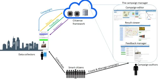
Una vez identificados los requisitos para la detecci ´on participativa, se propone un framework propio de detecci ´on participativa, llamado Citizense. Este framework incorpora todos los requisitos identificados con anterioridad en su dise ˜no e imple-mentaci ´on. Citizense est ´a dise ˜nado como un framework gen ´erico de detecci ´on participativa orientado al usuario, con el objetivo de hacer que la detecci ´on particip-ativa sea accesible para todos los usuarios, independientemente de su funci ´on (es decir, definici ´on de campa ˜nas de recopilaci ´on de datos, recopilaci ´on de los datos necesarios) y experiencia. El principio de dise ˜no central de Citizense es dividir un proceso complejo de participaci ´on en varias tareas de participaci ´on at ´omicas, donde cada tarea se ocupa de un solo tipo de dato o sensor. De esta manera, la campa ˜na de detecci ´on participativa se puede dise ˜nar a trav ´es de una interfaz gr ´afica de usuario donde los detalles t ´ecnicos complejos y las especificaciones se transforman en elementos visuales simples y comprensibles. Al mismo tiempo, el framework puede reutilizarse en diferentes escenarios y recopilar una amplia variedad de datos. Dos actores principales interact ´uan con Citizense: autores de campa ˜nas y recolectores de datos. Los primeros definen el proceso de detecci ´on participativa para recopilar ciertos datos y los ´ultimos proporcionan a los primeros los datos necesarios.
El framework de Citizense adopta una arquitectura cliente-servidor tradicional, con una plataforma central que contiene la l ´ogica de back-end (que incluye, gesti ´on de incentivos y contextos, l ´ogica de detecci ´on participativa general, manejo y pro-cesamiento de resultados), almacena todos los datos (es decir, datos administrat-ivos, campa ˜nas, resultados de participaci ´on) y sirve los resultados a las diversas aplicaciones de administraci ´on de campa ˜nas basadas en la Web ( Campaign Editor, Feedback Manager o Result Visualizer), y desde la parte del cliente, que consiste en la aplicaci ´on m ´ovil, que se conecta al servidor central y permite a los ciudadanos participar en campa ˜nas. Hay 4 componentes principales en la arquitectura de Citizense: el objeto campa ˜na, el servidor central, el administrador de la campa ˜na y la aplicaci ´on m ´ovil.
todos los detalles de una campa ˜na de detecci ´on participativa. El editor de la campa ˜na es capaz de crear un objeto campa ˜na, luego lo almacena en el servidor central y lo env´ıa a la aplicaci ´on m ´ovil para su ejecuci ´on.
A este servidor central se le asignan tres tareas principales: (i) facilitar a los recolectores de datos las campa ˜nas relevantes para el contexto en el que se encuentren, (ii) procesar los datos enviados por los recolectores, (iii) enviar retroalimentaci ´on en tiempo real a los recolectores de datos. El administrador de la campa ˜na tiene asignadas dos tareas principales: (i) crear los objetos de la campa ˜na, y (ii) visualizar los resultados. Finalmente, la aplicaci ´on m ´ovil se instala en los dispositivos de los recolectores de datos y se le asignan dos tareas principales: (i) recibir y visualizar objetos campa ˜na, y (ii) ser el punto de entrada para los recolectores de datos.
Este framework fue probado por validar su escalabilidad, que es una cara-cter´ıstica importante de la detecci ´on participativa. Durante estas pruebas de estr ´es, el framework Citizense mostr ´o estabilidad. Espec´ıficamente, el tiempo de respuesta se midi ´o en tres escenarios diferentes: un gran n ´umero de campa ˜nas; campa ˜nas complicadas con una gran variedad de tipos de tareas y par ´ametros; y con un gran n ´umero de solicitudes simult ´aneas. Las pruebas de estr ´es afirmaron que Citizense se desempe ˜n ´o bien en estas duras condiciones. M ´as concreta-mente, el tiempo de respuesta medio fue inferior a 500 milisegundos. Adem ´as, el despliegue en la nube permite de forma sencilla su ampliaci ´on, en caso de que se requiera un rendimiento m ´as estricto.
Se implement ´o un framework operacional de Citizense en dos escenarios del mundo real, en los que las funcionalidades y caracter´ısticas del framework se probaron con participantes reales y se obtuvieron resultados para el an ´alisis y discusiones adicionales. En el primer despliegue, se us ´o Citizense para recopilar comentarios de los participantes del marat ´on anual de la ciudad de Castell ´on. Se cre ´o una campa ˜na mediante el creador de Citizense, la que estuvo disponible en espa ˜nol, catal ´an e ingl ´es, y estaba formada de 28 preguntas. Esta campa ˜na se ca-racteriz ´o por tener sus preguntas vinculadas mediante transiciones condicionales e incondicionales. Hubo 180 participantes involucrados en este despliegue, entre ellos 140 participantes enviaron sus comentarios. Se recibieron 10 env´ıos realiza-das en modo fuera de l´ınea.
El segundo despliegue tuvo lugar en el campus de la Universitat Jaume I, en el que participaron 359 usuarios en 20 d´ıas. Entre estos 359 participantes, hubo
230 recolectores de datos (99 hombres y 131 mujeres). En este despliegue, hubo 44 campa ˜nas lanzadas secuencialmente, entre ellas 7 campa ˜nas se aplicaron con 3 mecanismos de incentivos diferentes (loter´ıa, micropago fijo y micropago variable). Respecto a la autor´ıa de las campa ˜nas, 10 campa ˜nas fueron creadas por el organizador y el resto (34 campa ˜nas) las crearon los usuarios, utilizando el administrador de campa ˜nas. Durante el per´ıodo de 20 d´ıas, este despliegue recibi ´o 4.167 solicitudes y 2.944 env´ıos de datos para las 44 campa ˜nas.
A trav ´es de las 7 campa ˜nas aplicadas con incentivos, se estudi ´o la reacci ´on de los usuarios. Se observ ´o que los mecanismos de incentivo aumentan sustan-cialmente la participaci ´on de los recolectores de datos. Entre los mecanismos de incentivos implementados, el micropago fijo supero al micropago variable. El orden de aceptaci ´on general que se pudo fijar fue: micropago fijo > pago al estilo de loter´ıa > micropago variable > sin incentivo. Adem ´as, se comprob ´o la reacci ´on de los usuarios dependiendo del g ´enero y la edad. El mismo orden entre los mecanismos de incentivo mostrado de forma general, se puede establecer en los diferentes grupos de recolectores de datos masculinos, femeninos, j ´ovenes y an-cianos. Finalmente, se observa que existe una correlaci ´on negativa entre la edad y la cantidad de env´ıos, a edad m ´as avanzada menos env´ıos se presentan. Usando la hora y la ubicaci ´on de los env´ıos, se pueden obtener varias conclusiones sobre el comportamiento del usuario. En primer lugar, los recolectores de datos tienden a presentar datos durante la noche. Sin embargo, para ciertas campa ˜nas, como las adaptadas al contexto, los env´ıos se realizaron en el momento en que los usuarios accedieron a la campa ˜na. En segundo lugar, distinguimos dos grupos de recolectores de datos: un grupo m ´as activo de recolectores de datos, que usan regularmente la aplicaci ´on m ´ovil, y un mayor n ´umero de recolectores de datos regulares, que usan la aplicaci ´on m ´ovil con menos frecuencia. Tercer punto, si una campa ˜na ten´ıa un contexto geogr ´afico, un porcentaje significativo de los env´ıos se realizaba dentro del ´area definida. En conclusi ´on, la tesis ha abordado completa-mente las preguntas de investigaci ´on. La tesis ha contribuido a la creaci ´on de Citizense, un framework de detecci ´on participativa y al estudio de diferentes as-pectos del comportamiento del usuario en el contexto de la detecci ´on participativa. Tambi ´en se presentan diferentes direcciones de futuras investigaci ´on.
Palabras clave: detecci ´on participativa, comportamiento del usuario, incentivos,
Abstract
The widespread use of mobile devices has given birth to participatory sensing, a data collection approach leveraging the sheer number of device users, their mobility, intelligence and device’s increasingly powerful computing and sensing capabilities. As a result, participatory sensing is able to collect various types of information at a high spatial and temporal resolution and it has many applications ranging from measuring cellular signal strength or road condition monitoring to observing the distribution of birds. However, in order to achieve better results from participatory sensing, some issues needed to be dealt with. On a high level, this thesis addressed two issues: (1) the design and development of a participatory sensing framework that allows users to flexibly create campaigns and at the same time collect different types of data and (2) the study of different aspects of the user behaviors in the context of participatory sensing.
In particular, the first contribution of the thesis is the design and development of Citizense, a participatory sensing framework that facilitates flexible deployments of participatory sensing campaigns while at the same time providing intuitive interfaces for users to create sensing campaigns and collect a variety of data types. During the real-world deployments of Citizense, it has shown its effective-ness in collecting different types of urban information and subsequently received appreciation from different stakeholders. The second contribution of the thesis is the in-depth study of user behavior under the presence of different monetary incentive mechanisms and the analysis of the spatial and temporal user behavior when participants are simultaneously exposed to a large number of participatory sensing campaigns. Concerning the monetary incentive, it is observed that par-ticipants prefer fixed micro-payment to other mechanisms (i.e., lottery, variable micro-payment); their participation was increased significantly when they were given this incentive. When taking part in the participatory sensing process,
par-ticipants exhibit certain spatial and temporal behaviors. They tend to primarily contribute in their free time during the working week, although the decision to respond and complete a particular participatory sensing campaign seems to be correlated to the campaign’s geographical context and/or the recency of the parti-cipants’ activities. Participants can be divided into two groups according to their behaviors: a smaller group of active participants who frequently perform participat-ory sensing activities and a larger group of regular participants who exhibit more intermittent behaviors
Keywords: participatory sensing, user behavior, framework, monetary incentive,
Contents
Resumen v Abstract xi Acronyms xxiii 1 Introduction 1 1.1 Motivation . . . 11.2 Research challenges in participatory sensing . . . 4
1.3 Contributions . . . 7
1.4 The GEO-C joint doctorate program . . . 11
1.5 Thesis organization . . . 13
2 Backgrounds and related works 15 2.1 Participatory sensing . . . 15
2.1.1 Introduction . . . 15
2.1.2 Classification of participatory sensing . . . 17
2.1.3 Participatory sensing applications . . . 18
Noise monitoring . . . 18
Traffic monitoring . . . 19
Radio signal monitoring . . . 19
Environmental monitoring . . . 19
City incidents monitoring . . . 20
Other applications . . . 20
2.1.5 Comparison of participatory sensing applications and
frame-works . . . 25
2.2 The use of incentive in participatory sensing . . . 32
2.2.1 Classification of incentives . . . 32
2.2.2 Deployments of monetary incentive in a real context . . . . 34
2.3 Users’ spatial and temporal behaviors . . . 36
2.3.1 The use of spatial and temporal coverage in user recruitment for participatory sensing . . . 36
2.3.2 The users’ spatial and temporal behavior in contributing data 38 3 The Citizense framework 41 3.1 The design principle . . . 41
3.2 The Citizense architecture . . . 43
3.2.1 The campaign object . . . 43
3.2.2 The central platform - Storage layer . . . 45
3.2.3 The central platform - Application logic layer . . . 46
3.2.4 The central platform - Application layer . . . 47
3.2.5 The mobile application . . . 47
3.3 The implementation . . . 48
3.3.1 The campaign object . . . 48
3.3.2 The central platform - Storage layer . . . 48
3.3.3 The central platform - Application logic layer . . . 48
3.3.4 The central platform - Application layer . . . 52
Campaign creator . . . 52
Result visualization and feedback manager . . . 55
3.3.5 The mobile application . . . 58
3.3.6 Comparison of Citizense and other applications . . . 62
3.4 Technical testing of the framework . . . 65
3.4.1 Accuracy of measurement . . . 65
3.4.2 Scalability of the framework . . . 66
4.1 The Castell ´on marathon . . . 69
4.1.1 The goals of the deployment . . . 69
4.1.2 The setup and progress of the deployment in the marathon 69 4.1.3 The results . . . 70
4.1.4 Discussions . . . 71
4.2 The deployment in UJI campus . . . 72
4.2.1 The goals of the deployment . . . 72
4.2.2 The setup and progress of the deployment . . . 73
4.2.3 The results . . . 77
4.2.4 Discussions . . . 78
4.2.5 Limitations of the UJI deployment . . . 81
5 The effectiveness of monetary incentives 83 5.1 Raw data and descriptive analysis . . . 84
5.2 Overall statistical analysis . . . 90
5.3 Studying the influence of gender . . . 97
5.4 Studying the influence of data collectors’ age . . . 100
5.5 Further analysis on incentive mechanisms . . . 104
5.6 Conclusions of the effectiveness of monetary incentive . . . 109
6 Temporal and spatial user behavior 113 6.1 Temporal user behavior: frequency of use . . . 114
6.2 Temporal user behavior: distribution of use . . . 117
6.3 Spatial user behavior . . . 119
6.4 Conclusions on the user behavior in participatory sensing . . . 126
7 Conclusions 129 7.1 Answers to the research questions . . . 130
7.2 Contributions of the thesis . . . 132
7.3 Results of the thesis . . . 133
7.4 Limitations . . . 134
A The campaign on usability and user feedback 139
B The details of the campaigns in the UJI depoyment 141
List of tables
2.1 Analyzing the selected participatory sensing applications . . . 27
2.2 Analyzing the selected participatory sensing applications (continued) 28 2.3 Analyzing the selected participatory sensing applications (continued) 29 3.1 The campaign object. . . 49
3.2 The participant object. . . 50
3.3 The object result. . . 50
3.4 Definitions of the primitives used in the logical expression . . . 55
3.5 How can Citizense substitute other existing participatory sensing applications and frameworks . . . 64
4.1 The different parameters of the campaigns with incentives. . . 76
5.1 The results of the Mann-Whitney U test with and without BH cor-rection for all pairs of incentive mechanisms, using the number of opens during the full period (all) and only weekdays. . . 94
5.2 Average openings per incentive mechanism, for all campaigns C1–C4. 94 5.3 The results of the Mann-Whitney U test with and without BH cor-rection for all pairs of incentive mechanisms, using the number of submissions during the full period (all) and the weekdays. . . 95
5.4 Average submissions per incentive mechanism, for all campaigns C1–C4. . . 96
5.5 The results of the Mann-Whitney U tests with and without BH cor-rection for all pairs of incentive mechanisms, using the number of submissions from female and male data collectors. . . 98
5.6 Average submissions per incentive mechanism by all female and male data collectors, for all campaigns C1–C4. . . 100 5.7 The results of the Mann-Whitney U tests, with and without BH
correction for all pairs of incentive mechanisms, using the number of submissions from younger and older data collectors. . . 103 5.8 Average submissions per incentive mechanism by younger and
older data collectors, for all campaigns C1–C4. . . 104
6.1 The on-target ratio of the geographically-related campaigns with different values of buffer distance d. . . 124
A.1 The questions on the usability of the Citizense mobile application . 139 A.2 The questions on the the concept of participatory sensing . . . 140
B.1 Overview of all campaigns available during the deployment, sorted by the number of submissions. . . 142 B.2 Overview of all campaigns available during the deployment, sorted
List of figures
1.1 The structure of the GEO-C program. . . 12 1.2 The general structure of the thesis. . . 13
3.1 The Citizense application ecosystem. . . 42 3.2 The architecture of Citizense framework. . . 43 3.3 Activities performed by the data collectors using the central platform
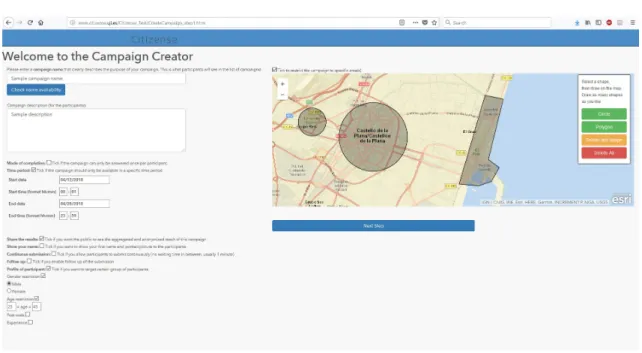
- application layer. . . 53 3.4 The graphical campaign creator. Creating a campaign, step 1:
Specifying the various parameters of the campaign. . . 54 3.5 The graphical campaign creator. Creating a campaign, step 2:
Defining the atomic sensing tasks and their transitions. . . 56 3.6 The visualization of the results. (left) The grouping by submission,
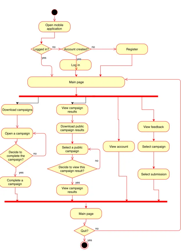
each submission’s status can be updated, at the bottom of the picture. (right) The grouping by task. . . 56 3.7 Visualizing the results on a map . . . 57 3.8 Activities performed by the data collectors using the mobile application. 59 3.9 The client mobile application. From left to right (1) An atomic sensing
task. (2) The list of available campaigns. (3) The details of a participant’s account. (4) The status/feedback of the submissions. 61
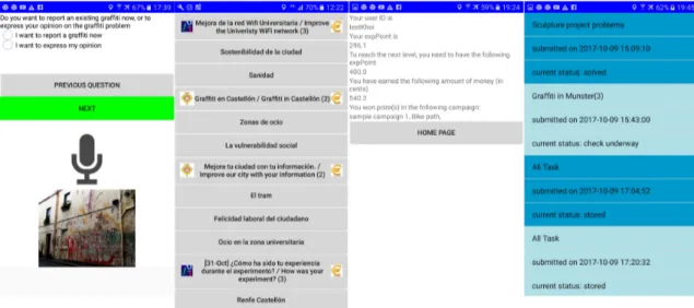
4.1 Example of the submissions during the deployment displayed by the Citizense result visualizer. (upper) The different text answers to a text-input task. (lower) The pictures and locations of the graffiti gathered by data collectors. . . 79
5.1 The number of list views of the campaigns. For each individual bar, dark (bottom part) and light color (top part) represent weekdays
and weekends, respectively. . . 85 5.2 The number of opens of the campaigns. For each individual bar,
dark (bottom part) and light color (top part) represent weekdays
and weekends, respectively. . . 86 5.3 The number of submissions of the campaigns. For each individual
bar, dark (bottom part) and light color (top part) represent
week-days and weekends, respectively. . . 87 5.4 The completion ratios of the campaigns based on all days. . . 88 5.5 The general completion ratios of the campaigns based on all days. 89 5.6 The attraction indexes of the campaigns based on all days. . . 89 5.7 The age count and average number of submissions per person per
age, for campaigns C1–C4. . . 102 5.8 The approximate order of the incentive mechanisms, for the
over-all data collectors and their subgroups based on number of sub-missions (significance level of 0.05). The significant differences between the mechanisms are marked by red arrows. . . 108
6.1 An illustrative example of requests sent by a typical data collector over time, each request is represented by a blue dot. A session is a cluster of requests, marked by the red ellipses. . . 115 6.2 The number of sessions (blue) and average number of request per
session (red) for every data collector throughout the deployment considering a separation time x = 600 seconds, decreasingly ranked according to the number of sessions. . . 117 6.3 The distribution of all received requests and submissions throughout
the deployment rendered in a 24-hour time frame. . . 118 6.4 The distribution of submissions from different campaigns throughout
the deployment rendered in a 24-hour time frame. (upper) The campaigns having different patterns than the overall submission pattern. (lower) The campaigns having a similar pattern to the overall submission pattern. . . 119 6.5 The taxonomy of campaigns used in the Citizense deployment. . . 121
6.6 The data collectors’ spatial pattern in different campaigns. (left) submissions from campaign 1 (geographically-neutral) addressing the topic of citizen participation, with the black rectangular frame covering the map extent on the right side. (right) submissions from campaign 14 (geographically-related) asking feedback on the city’s only tram line, with the blue line representing the tram route and the purple area representing the buffer of 400 meters. . . 122 6.7 The submissions of the campaign ”City tram line”, represented by
the red points. (left) The 400-meter catchments around the tram stations. (right) The 400-meter circular buffers around the tram stations. . . 126
Acronyms
AES Advanced Encryption Standard
API Application programming interface
APK Android Package
BSSID Basic Service Set Identifier
CPU Central processing unit
CSM Cross-community mining and sensing
CSS Cascading Style Sheets
GPS Global Positioning System
GSM Global System for Mobile communications
HTML Hypertext Markup Language
HTTP Hypertext Transfer Protocol
ICT Information and communications technology
iOS a mobile operating system created and developed by Apple
JSON JavaScript Object Notation
LTE Long-Term Evolution, a 4G mobile communications standard
OCT Open City Toolkit
PR Public relations
SSID Service Set Identifier
SUS System Usability Scale
UJI Universitat Jaume I
Chapter 1
Introduction
The main goal of this introductory chapter is to familiarize the readers with the concept of participatory sensing. In this chapter, we define what is participatory sensing, why it is needed in the current urban context and the challenges facing participatory sensing. We continue with examples of existing participatory sensing applications and frameworks, and subsequently point out their strengths and weaknesses. As a result of this analysis, this thesis is dedicated to the introduction of Citizense participatory sensing framework and the study of the framework’s effectiveness in collecting urban information as well as the participants’ behavior in the participatory sensing context.
Chapter 1 is organized as follows: Section 1.1 presents the motivation for the development of participatory sensing. The research challenges in the field of participatory sensing are presented in Section 1.2. Section 1.3 details the contribution of this thesis to the participatory sensing body of knowledge. Section 1.4 describes the Geo-C Joint Doctorate program, aiming to enable Open cities. In this context, the Citizense framework acts as a tool for citizens to collect different types of urban data and communicate with the local authority. Finally, Section 1.5 details the outline of the thesis.
1.1
Motivation
The world population is growing at a considerably fast pace. Based on the num-ber given by the United States Census Bureau, the world population is at 7,475
billions1 (as of today 26 May 2018). According to well-established projections, the world population will reach at least 8.75 billions in 2050 (Lutz et al., 2017) and 11,184 billions in 2100 (United Nations, 2017). This growing population have caused problems such as depletion of natural resources and degradation of envir-onment. Another problem with the growing population is its uneven distribution, with more people living in urban areas than anywhere else. It is reported that 54% of the world population are currently living in metropolitan areas, and this number is expected to reach 66% by 2050 (United Nations, 2014). As a result, the term ”megacities” is coined to represent cities whose population exceed 10 millions inhabitants (Cross, 2001; United Nations, 2008). The list of megacities is also growing; some examples are Tokyo, Delhi and Shanghai (in Asia), Paris, London and Moscow (in Europe), Lagos (in Africa), New York (in North America) and S ˜ao Paulo (in South America).
The process of urbanization can bring about positive changes as it allows easier access to education, health care, transportation, energy supply and water for a sub-stantially large number of inhabitants. However, at the same time, this urbanization process has its inherent problems and issues. Examples are overcrowdedness, traffic congestion, environmental pollution, crime and safety issues, the impact of natural disasters, unemployment and lack of housing. The United Nations, in their report, suggested the use of Information and Communication Technology (ICT) to resolve the problems brought by urbanization (United Nations, 2014).
Specifically, this use of ICT in cities and urban areas are directly related to the concept of Smart Cities - a concept that aims to provide a sustainable, safe and liveable environment for all the inhabitants. Due to its importance, Smart Cities have gained the attention of many scholars, practitioners, the government and citizens; there have been many definitions of Smart cities (Albino et al., 2015). From a holistic point of view, the Smart cities concept typically includes 6 domains: smart economy, smart people, smart governance, smart mobility, smart environment and smart living (Rudolf et al., 2007). At the center of the Smart Cities concept is the demand to collect different types of information in an efficient and proper manner and later process, store and visualize the obtained information. Historically, information was obtained through the use of wireless sensor networks (WSN) (Yick et al., 2008). Recently, the advent of modern Internet-connected
smartphones with powerful sensing and processing capabilities has given birth to a new data collecting approach: participatory sensing, which combines the mobility of people and the computing power of these devices. Specifically, participatory sensing is the concept in which a (large) group of people contribute (sensory) information to form a body of knowledge. To illustrate this participatory sensing concept, let us consider the following example of creating a noise map in the city. Noise pollution has been proven to cause many adverse effects on the human health, such as contribution to cardiovascular effects and an increased incidence of coronary artery disease (M ¨unzel et al., 2018; Hoffmann et al., 2006). As a result, there is a demand for the control of noise pollution, especially in big cities and urban areas. A necessary condition for implementing noise control is the creation of a city’s noise map. Traditionally, this noise map can be created by interpolating the measurements from the relatively few dedicated measuring stations across the city. Accurate noise measurements are recorded at these fixed locations, while the measurements in other locations has to be computed from these established values. In contrast, participatory noise measuring can quickly provide a high-resolution city-wide weather map compiled from thousands of in-situ measurements spread across the city produced by the participants’ smartphones. In this noise measuring example, the participatory measuring approach shows its merits as noise data can be collected with high granularity in space and time (D’Hondt et al., 2013).
In parallel with the issue of measuring noise, there is a demand for reporting the presence of mosquitos in the city due to the surge of malaria caused by mosquitos. It is believed that computers and sensors are not effective in detecting the presence of mosquito, or it takes a considerable amount of time, money and efforts to build a system that can effectively detect mosquitos. In contrast, humans are quicker and more effective in detecting the mosquitos surrounding them. As a result, the task of detecting mosquitos can be completed much quicker and with higher accuracy by humans. Information on the presence of mosquitos produced by a large number of individuals might be aggregated into a comprehensive real-time map of mosquitos in the city2.
In these two simple examples, the advantages of participatory sensing are revealed. In the first example of noise measuring, participatory noise measuring
leverages the vast amount of smartphones to produce a large number of meas-urements (or data in general). In the second example of reporting mosquitos, the involvement of humans are decisive when computers cannot handle the task efficiently. Furthermore, as the participants constantly move in the city, the spa-tial coverage of this participatory sensing is much more extensive than WSN. In terms of capital, participatory sensing is relatively affordable as it does not require any new investment in terms of hardware; it reuses the existing communication infrastructure (LTE, WiFi) which is becoming more pervasive over time. The big task (i.e., measuring noise and reporting mosquitos) in a city-wide scale is divided among the large number of participants, each participant is expected to carry out several simple measurements/observations. In the ideal case, if all the inhabitants of the city join this participatory sensing effort then the resulting high-quality noise map/mosquito map will cover the whole city with several reports in each location. In general, participatory sensing is a promising approach to collect data, espe-cially in urban context, as it takes advantage of the massive number of participants who own devices with advanced sensing and processing capabilities, their constant mobility and the pervasive communication network. As a result, the data produced by participatory sensing processes have high spatial and temporal resolution. Furthermore, participatory sensing can be applied in a variety of domains, as demonstrated in the surveys of (Khan et al., 2013; Guo et al., 2015; Jaimes et al., 2015; Lane et al., 2010).
1.2
Research challenges in participatory sensing
In order to fully exploit the strength of participatory sensing, there are several obstacles that must be overcome. Scholars have pointed out these obstacles in different works such as (Kanhere, 2011; Kapadia et al., 2009; Guo et al., 2015; Gao et al., 2015b; Guo et al., 2016; Montori et al., 2018b). The main research challenges in the field of participatory sensing are the followings:
• Challenge 1 - Privacy of the participants (Christin, 2016; Montori et al., 2018b): The prime actor behind participatory sensing are humans, who
actively collect data for the common good of the society. During this process, they intentionally or unknowingly reveal the context of the data collection, which in some cases is sensitive. For example, the location and time of the data is added to the measurement to make it meaningful and complete. As
a result, some participants might lose their interest in joining participatory sensing activities as they fear that their data privacy is not protected. Certain privacy mechanisms need to be exercised to ensure the participants’ privacy, such as using a unique pseudonym (Deng and Cox, 2009), periodic pseud-onym (Christin et al., 2012), data perturbation (Zhu et al., 2013) and spatial cloaking (Agir et al., 2014).
• Challenge 2 - Enhancing and guaranteeing the quality of the collected data (Budde et al., 2017): The result of participatory sensing is built on
the data contribution of the participants, therefore it can be affected by several factors, both subjective and objective. Subjective factors include the malicious intentions or unintentional errors from the participants while objective factors can be privacy regulations, device calibration and lack of information/participants. This challenge spans across several domains such as user recruitment (Yao et al., 2015), incentive mechanism (Peng et al., 2015; Gao et al., 2015a) and device calibration (Luo et al., 2018; Markert et al., 2016).
• Challenge 3- The reusability of the participatory sensing platforms (Tangmunarunkit et al., 2015): The list of participatory sensing
applica-tions has been growing. However, many of them are designed to function within limited use cases. As a result, there are a multitude of applications sharing the same functionalities, workflow or data to be collected. From the participants’ point of view, a large number of applications with limited functionality, and their overlapping purposes can cause confusion and hinder their effective participation. In order to avoid the limitations of these ap-plications, the idea of reusable participatory sensing applications has been developed and realized in several implementations (Brunette et al., 2013; Zaman and Meuter, 2015; Kim et al., 2013). The resulting participatory sensing applications are able to collect a variety of data types and they can be used across different scenarios.
• Challenge 4 - Incentivizing the participants (Restuccia et al., 2016): The
results produced by the participatory sensing approach are meaningful only if there is a relevant number of participants producing an adequate number of contributions. In this process, participants might be negatively affected
by subjective obstacles (i.e., privacy concerns, distraction by other mobile apps) and objective obstacles (i.e., battery and mobile data consumption, memory occupation). Therefore, it is recommended to compensate the costs occurred during the participatory sensing process and motivate the participants through the use of incentives. The incentives can come in the form of monetary incentives (Reddy et al., 2010a) and non-monetary incentive, which includes reputation points (Ueyama et al., 2014; Silva et al., 2013b), gamification techniques (Arakawa and Matsuda, 2016), and the exchange of useful information (Yan et al., 2011).
• Challenge 5 - Integrating participatory sensing with participatory so-cial media (Guo et al., 2014): Apart from the physical world, another
valu-able source of user-generated information is from the virtual societies (e.g., social media networks). For instance, for the same sensing object (e.g., an event in the city), it might be reflected in different ways through participat-ory sensing and social media networks. However, the reflections from the physical and virtual world usually complement each other, resulting in the need for the integration and fusion of the information from these worlds. In this direction, cross-community sensing and mining (CSM) is a new research area that addresses this demand. In this area, researchers tries to link the virtual world and the physical world through tools such as location-based social networks (Lima and Musolesi, 2012) and event-based social networks 3. Other works focus on the definition of cross-community modeling and measurement metrics, which can shed more light on the complex interaction between the physical and the virtual world. In parallel with these works, the question whether it is possible to transfer knowledge between one world (e.g., physical) to another (e.g., virtual) is crucial as it can enhance the performance of the latter (Tang et al., 2012).
• Challenge 6 - Trust and reputation (Mousa et al., 2015): As participatory
sensing entirely relies on the voluntary data contribution of the users, it might be subjected to erroneous data, produced intentionally or unintentionally by the users. Therefore it is desirable to monitor the user behavior closely so that estimation on the users’ honesty can be made. On one hand, malicious
users can launch different types of attack (e.g., corruption attack, on-off attack, GPS spoofing (Premchaiswadi et al., 2011), discrimination and Sybil attack (Wei et al., 2012)) to the participatory sensing system. On the other hand, several trust and reputation system have been built (Zhang et al., 2012; Irissappane et al., 2012)
• Challenge 7 - Fairness (Montori et al., 2018b): Fairness is crucial in
participatory sensing as it helps to keep users being involved and prevent them from dropping out as they are not selected as data collector. This characteristic is in direct contrast with data trustworthiness, in which data quality takes precedence over broad participation of users. Fairness are often tackled in conjunction with incentive mechanism Lee and Hoh (2010a), in which a balance between optimal data quality and the well-being of users is the ultimate goal.
• Challenge 8 - Interoperability (Montori et al., 2018b): As the number
of participatory sensing applications and the amount of data generate by these applications grow constantly, many of these applications function as silos. They have full control on the process of collecting and aggregating data and do not allow co-operation among each other. Therefore, it is desirable to increase the interoperability among applications by allowing them to exchange data, such as the works from (Soldatos et al., 2015) and (Montori et al., 2018a)
1.3
Contributions
Among the aforementioned research challenges, this thesis focuses on the issues of reusability in participatory sensing and incentivizing the participants. As the current trend in participatory sensing, reusable participatory sensing applica-tions offer several benefits for different stakeholders. For end-users, they can have a smaller number of applications to deal with, resulting in better user experience. For the participatory sensing organizers, they can drastically reduce the cost of building and maintaining their software applications. For the researchers, they can study several aspects of the user behavior, interaction and preference as users are simultaneously exposed to a number of participatory sensing campaigns and topics.
Participatory sensing entirely relies on the voluntary involvement of users to collect a large amount of information in different spatial and temporal context. Furthermore, users have to bear tangible costs (e.g., energy consumption, data consumption) and intangible cost (e.g., the fear of losing privacy) caused by this data collection process. Therefore, it is desirable to provide users with certain incentives to compensate these costs.
Based on the focuses mentioned above, the following three research questions are formulated:
• RQ1 - What are the necessary characteristics and functionalities of a (multi-purpose) participatory sensing framework?
Due to the different benefits of reusable participatory sensing applications, it is desirable to create such a reusable participatory sensing application (participatory sensing framework). However, there are a large number of participatory sensing applications and several participatory sensing frameworks already existing and they greatly differ from each other in terms of functionality and characteristics. As a result, it is necessary to build such a framework that possesses all the necessary features. The answer to this research question will provide a list of characteristics and functionalities required for the implementation of the framework in question, which is one of the solution for research challenge 3.
• RQ2 - How do participants behave in a participatory sensing context?
The study of user behavior in participatory sensing will provide more under-standing on how users perform their sensing tasks. Once these information are obtained, they can be used to improve the participatory sensing process as well as the applications. The answer to this research question can be partially used to address research challenge 2.
• RQ3 - How can organizers motivate the participants to contribute in particip-atory sensing through the use of monetary incentive?
This research question is directly related to research challenge 4. RQ3 seeks to understand what kinds of monetary incentive are effective in boosting the involvement of users in participatory sensing. Monetary incentive is selected as
it is generic and can potentially be incorporated in every participatory sensing applications.
This thesis has three main objectives. The first objectives is to identify and study the important characteristics of participatory sensing. Second, based on the identified characteristics, a multi-purpose participatory sensing framework is then designed and implemented, incorporating the identified characteristics. Finally, the resulting framework is then tested in real-world scenarios to verify its characteristics and to discover the different aspects of user behavior in the participatory sensing context. Due to the fact that the developed framework is used as a vehicle to study user behavior in participatory sensing, the research challenge 5 and 6 and the accuracy of results (part of research challenge 2) are not tackled in this thesis. However, certain aspects of other research challenges are throughly considered during the development of the framework. Research challenge 1 is partially addressed by the use of pseudonym for each data collectors in the framework. A rigid user recruitment based on location, time and user profile is proposed as one of the solutions to research challenge 2. Challenge 3 is fully addressed in this thesis by the creation of the Citizense multi-purpose participatory sensing framework. Subsequently, the research challenge 4 is one of the main focuses of this thesis as it seeks to study how the users react under the presence of (monetary) incentives. Research challenge 7 is partially considered through the theoretically fair nature of the monetary incentives implemented in the framework. Finally research challenge 8 is partially answered as the Citizense framework incorporates a data gateway which allows other applications to query data collected by this framework.
Concerning the research question RQ1, I have identified the set of requirements for a participatory sensing framework. This set stems from the extensive review of existing participatory sensing applications; it contains 7 functional requirements and 2 non-functional requirements. The functional requirements are the following:
• F1 - Multi-purpose: the participatory sensing framework should be able to collect different types of information (e.g., sensory input, multimedia content, input from human participants).
• F2 - Coping with network interruptions: the participatory sensing framework should be able to tolerate disruption in the communication network.
• F3 - Participant identity: The participatory sensing framework should be able to identify participants.
• F4 - Ability to flexibly specify content for the sensing campaign: the author of a sensing campaign should be able to manage the content of a sensing campaign.
• F5 - Context-aware information gathering: the participatory sensing frame-work should be able use the participants’ context information to select eligible participants.
• F6 - Incentives for participants: Incentives should be used to motivate parti-cipants and compensate the costs resulted from the their sensing activities.
• F7 - Security and privacy for collected data: The collected data should be protected from unauthorized access.
The non-functional requirements are the following:
• NF1 - Inclusiveness: The framework should be easily understandable and us-able, given the diverse backgrounds of participants in an urban environment, possibly those with limited computer knowledge.
• NF2 - Transparency: The participatory sensing process should be transpar-ent to the participants (e.g., participants should be able to view the submitted results and to receive feedback on their submissions).
Based on this set of requirements, we have designed and developed Citizense, a multi-purpose participatory sensing framework that aims to make participatory sensing accessible to all users, regardless of their role (i.e., defining data collection campaigns, gathering the required data) and computer skills. As a multi-purpose participatory sensing framework, Citizense is designed as a union of other ap-plications; it combines and extends the functionalities of existing participatory sensing applications and frameworks. Subsequently, Citizense was deployed in two occasions in which the framework was used by hundreds of people. In these deployments, its designed functionalities were showcased and the framework
was appreciated by different stakeholders. Particularly in the second deployment, Citizense has been proved to be effective in collecting urban data.
By using the Citizense as a vehicle to study the participant’s behaviors, we were able to answer research question RQ2 by studying the participants’ behaviors and identifying their (spatial and temporal) patterns, which is under-investigated. It can be concluded that (i) the Citizense framework can effectively help parti-cipants to design data collecting processes and collect the required data, (ii) data collectors primarily contribute in their free time during the working week; much fewer submissions are done during the weekend, (iii) the decision to respond and complete a particular participatory sensing campaign seems to be correlated to the campaign’s geographical context and/or the recency of the data collectors’ activities, (iv) data collectors can be divided into two groups according to their behaviors: a smaller group of active data collectors who frequently perform parti-cipatory sensing activities and a larger group of regular data collectors who exhibit more intermittent behaviors.
Finally, through one of the deployments of Citizense, we studied the effectiveness of monetary incentives in motivating participants to contribute their data; this study addresses the third research question RQ3. It is concluded that (i) in general, monetary incentives work to improve participation rate; (ii) for the overall population, a general descending order in terms of effectiveness of the incentive mechanisms can be established: fixed micro-payment first, then lottery-style payout and finally variable micro-payment.
1.4
The GEO-C joint doctorate program
Urbanization has been a key trend for centuries and is expected to continue throughout the 21st century as well. Cities have to continuously strive to provide a sustainable, safe and liveable environment for their ever-increasing populations. In recent years, the term ‘smart cities’ has been coined for initiatives that monitor and analyse different aspects of urban life, and manage service provision intelligently. A key gap in this area relates to how people can understand the processes driving smart cities and their services, and how they can gain a sense of control rather than being controlled by the services provided by a smart city. In this context, GEO-C, a Joint Doctorate program in GeoInformatics, was created to further research in this direction. Specifically, GEO-C aims to contribute methods and
tools to realize smart and open cities, in which all groups of society can participate on all levels and benefit in many ways.
Figure 1.1: The structure of the GEO-C program.
The main goal of GEO-C is to make substantial scientific progress towards the notion of open cities, i.e. smart cities that are open to all citizens and facilitate participation on all levels. To do so, the GEO-C program has three main research strands: analysis and fusion, deep participation and services (see Figure 1.1); there will be 15 theses completed during the GEO-C program. The topic of this thesis (ESR 06) lies in the strand of deep participation as this thesis looks into the interactions among the citizens, the ICT platforms, the data available in the city and the local authorities.
Throughout the GEO-C program, different findings turned into reusable tools for cities are compiled in the Geo-C Open City Toolkit (OCT). Aiming to enable open cities, the OCT compiled and aggregated different tools useful for cities looking to increase citizens participation and transparency. My contribution to the OCT includes the Citizense participatory sensing framework and a guideline for effective usage of the framework.
My first contribution, the Citizense framework, consists of a front-end web interface, a front-end mobile application, and a back-end server. After thorough laboratory testings and several field deployments, this framework is added to the OCT in the category of ”App and Services”. As an open source software, the source code of the Citizense framework is accessible from the project’s OCT repository (Geo-C Joint Doctorate program, 2018), and it is redistributed under the Apache v2 license, which effectively makes the code reusable. As a result,
interested users can download, customize and deploy Citizense in their own ICT infrastructure.
My second contribution to the OCT is the guideline for using the Citizense participatory sensing framework. This guideline provides detailed description about the Citizense framework, its functionalities and steps to create a participatory sensing campaign using this framework. This guideline is added to the OCT in the category of ”Guidelines”. The intended readers of the guideline are prospective users (to operate the framework) and software engineers (to modify or customize the framework).
1.5
Thesis organization
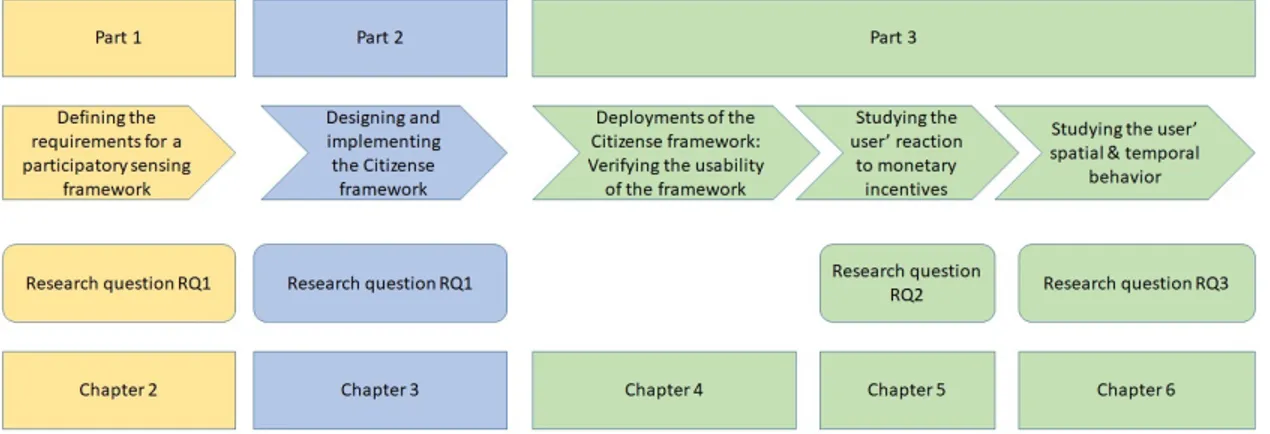
On a high level, the thesis is composed of three parts: the summary of the related works, the design and implementation of the Citizense framework and finally the discussions and analysis on the results of the Citizense deployments. In this structure, the research question RQ1 is fully answered in the first part. In the second part, the design and implementation of the Citizense framework will further clarify the answers to RQ1 as each characteristic and functionality will be explained using the Citizense framework. In the last part of the thesis, research question RQ2 will be addressed through the analysis of the user behaviors. Finally research question RQ3 will be answered by looking at the participants’ responses to the monetary incentives administered in a Citizense deployment.
Figure 1.2: The general structure of the thesis.
In terms of chapters, the thesis is composed of 7 chapters. Chapter 1 introduces the readers to the content of the thesis. Chapter 2 is dedicated to the summary of
the related works for the thesis. This chapter addresses the topic of participatory sensing, the use of incentive in participatory sensing and the user behaviors in participatory sensing. In this chapter, a set of key requirements for participatory sensing frameworks is formed. Chapter 3 details the design and implementation of the Citizense framework, which incorporate the identified requirements. Each component of the framework is described in this chapter. Chapter 4 details the various real-world deployments of the Citizense framework and their results. In Chapter 5, the users’ behaviors under the presence of monetary incentives are studied. Then in Chapter 6, the users’ spatial and temporal behaviors are studied and the corresponding patterns are analyzed. Finally Chapter 7 concludes the thesis.
Chapter 2
Backgrounds and related works
2.1
Participatory sensing
In this chapter we review the works concerning the participatory sensing concept, the classification of participatory sensing, different participatory sensing applica-tions and frameworks.
The rest of this chapter is organized as follows: In Chapter 2.1.1, the concept of participatory sensing is formally introduced. In addition, we also present the list of concepts and terms that are similar to participatory sensing. In Chapter 2.1.2, the classification of participatory sensing is provided. Chapter 2.1.3 describes examples of participatory sensing applications. Examples of participatory sensing frameworks are detailed in Chapter 2.1.4. Finally, in Chapter 2.1.5 we present a comparison of selected participatory sensing applications. At the end of this chapter, we formally define the set of key technical requirements that a participatory sensing application should possess.
2.1.1
Introduction
The term ”participatory sensing” was first coined in 2006 (Burke et al., 2006). In its definition, participatory sensing leverages modern mobile devices to create interactive and participatory sensor networks that allows people to collect, analyze and share information on certain topics. Specifically, this concept takes advantage of an increasing number of Internet-connected mobile devices incorporating em-bedded sensors with powerful sensing and computing capabilities; it also exploits
the mobility and intelligence of the device owners. From the definition, it is clear that the device owners (the people) are at the center of the data collecting process, which makes participatory sensing unique compared with other concepts such as WSN (Yick et al., 2008). An example of participatory sensing is the Waze application1 in which users actively report real-time traffic and road information for the benefit of the whole community.
Apart from participator sensing, there are several other concepts that repres-ent the process of collecting information through the contributions from a large number of participants. Notably, participatory sensing shares some similarities with ”citizen science”, ”crowdsensing”, ”volunteered geographic information” and ”user-generated content”. Each concept involves a variant of this information collecting process. For example, volunteered geographic information focuses on the collection of geographic information such as event location (Goodchild, 2007) while citizen science often includes the participation of non-expert users collecting environmental data across a large area over an extended period of time (Bonney et al., 2009). For the former, real-world implementations include OpenStreetMap 2(OSM), a worldwide project to create free and editable map data, where users collectively contribute the geographical contents. For the latter, there are several implementations that allow users to document various features of the surrounding environments such as presence and behaviors of birds3, light pollution at night 4 and changes in the weather 5; many of these implementations are indexed at scistarter6 and CitizenScience.org 7. Crowdsensing involves the collection of data sensed or generated from mobile devices which is later aggregated and analyzed in the cloud (Guo et al., 2015). While participatory sensing focuses on the active involvement of the users in the process of collecting and sharing data, opportunistic sensing represents a group of applications in which the users are not necessarily involved in that process (Campbell et al., 2006). However, the degree of user involvement in this data collecting and sharing process can vary among the applications or even among the users. As a result, mobile crowdsensing
1www.waze.com
2OpenStreetMap - https://www.openstreetmap.org
3Main bird atlas - https://www.maine.gov/ifw/fish-wildlife/maine-bird-atlas/index.html 4https://www.globeatnight.org/
5ISeeChange - https://www.iseechange.org/ 6https://scistarter.com/
reflects this broad range of user participation in which participatory sensing and opportunistic sensing are at the two opposing sides (Ganti et al., 2011). Other related terminologies describing the crowdsensing process are community sensing (Krause et al., 2008), urban sensing (Campbell et al., 2006) and people-centric sensing (Campbell et al., 2008).
2.1.2
Classification of participatory sensing
Based on the main characteristics of participatory sensing, it can be classified into different groups. The main characteristics in question are the involvement of the human user, the scope of the data collection, the source of the collected data and the architecture of the participatory sensing system.
The involvement of the human user significantly affects the operation of the participatory sensing concept; this concept emphasizes on the active participation of the users in the data collecting process (Khan et al., 2013). In contrast, if this active participation of the user is not required, the data collecting process can be branded as opportunistic sensing (Capponi et al., 2017).
Concerning the scope of participatory sensing, it can be classified as personal sensing, social or group sensing and public sensing (Khan et al., 2013). Personal sensing helps the users to collect and monitor data for themselves. An example of this personal scope is from Lu et al. (2009), the authors developed a standalone mobile application that classifies the sound types exposed by the users. Group sensing allows the data to be collected and shared among members of a group. For example, Bao and Roy Choudhury (2010) developed MoVi, a mobile phone-based video highlighting system. In its largest scope, public participatory sensing aims to collect and share data, which usually is environmental data, with everyone for the common good. For example, NoiseTube is a participatory noise mapping tool that transforms several individual noise measurements into a noise map in certain parts of the city.
Concerning the data source, participatory sensing can take data from the embed-ded sensors in the mobile device (e.g., microphone, GPS receiver, accelerometer) or the mobile social networks (Amintoosi and Kanhere, 2014). It is known that participatory sensing favors the use of data from the device’s embedded sensors (Zhang et al., 2016).
architectures. Due to the fact that the participatory sensing concept relies on the mobile devices to collect data and these devices have different sensing and computing capabilities, there are two approaches for the processing of data (Guo et al., 2013). In the first approach, data are processed in a centralized manner as the mobile devices send all the collected data to a central server for further processing. While in the second approach, the data are processed inside the mobile devices.
2.1.3
Participatory sensing applications
As mentioned in Section 2.1.2, participatory sensing has varying scopes. Among them, the public participatory sensing attracted the most attention as its results and outcomes can potentially benefit a large population. As a consequence, public participatory sensing is also the focus of this thesis. Furthermore, due to its potential to collect different types of data at a high spatial and temporal resolution, the concept of participatory sensing has been realized in a large number of applications, including public sensing applications.
In this section, we are going to review a number of selected participatory sensing applications; they represent the diversity and complexity of participatory sensing. These applications differ from each other in terms of age, theme, domain and characteristics. For a more comprehensive survey of existing participatory sensing application, we refer the readers to (Khan et al., 2013; Lane et al., 2010; Guo et al., 2015).
Noise monitoring
In this category, we selected Earphone (Rana et al., 2010), NoiseTube (D’Hondt et al., 2013) and SoundOfTheCity (Ruge et al., 2013) as the representatives for a large number of participatory noise measuring applications. These three applications turn the mobile devices into noise measuring devices by collecting the noise measurements produced by the device’s microphone and the GPS location of the corresponding measurements and later sending them to the back-end server for further processing and visualization. As a result, a collective noise pollution map can be generated based on the large number of individual submissions made by the participants.
Traffic monitoring
Waze is a well-known mobile application for reporting real-time traffic and road information such as accidents, congestions and potential dangers on the road (Silva et al., 2013b). All contributions from the users will be labeled with pre-defined categories; each contribution typically includes a text description, a photo and the current GPS location of the user.
In the same way, CrowdOut (Aubry et al., 2014) is an application dedicated to the reporting of traffic-related issues in cities. This application allows users to describe an issue using text, pictures, date, time and GPS location in a fixed structure. While having similar purposes and type of collected data, CrowdOut and Waze differ from each other in terms of scope and origin. The former is a prototype created by university researchers and tested in a small scope while the latter is a completed product from the industry and used by millions of users worldwide.
Radio signal monitoring
OpenSignal 8 is one of the most popular cellular signal strength monitoring applications incorporating the participatory sensing concept. It allows any smart-phone users to report various parameters of their received cellular signal (i.e., GSM, 3G, 4G LTE). Each report is attached with the exact GPS location of the signal measurement. Based on the numerous submissions from users, a detailed coverage map of the service providers can be generated for a city, a region or a country.
Environmental monitoring
The participatory sensing concept can be used in environmental monitoring. In this example, a bird watching platform take advantage of people’s observation on birds to collect various information that helps bird conservation (Wang et al., 2016). Specifically, users are asked to detail their observation with bird’s sound, pictures, text description and the observation’s location. These information are then processed in a central server and shared with the public. As a result, ecologists and biologists can benefit from the collected data while the public can raise their awareness on bird conservation.
BugMap is an research-oriented mobile application that enables users to report the location where a specific type of bug appears (Malek et al., 2018). Each report includes the date and time, geographic location, pictures of the bug, location of the bug (e.g., indoor, outdoor, green urban areas, bushes) and other parameters. Users will subsequently receive a feedback once their reports are analyzed by experts in this field.
MosquitoAlert9is a platform realizing the citizen science concept. Anyone with their mobile device can contribute data to the study of mosquito by reporting the presence of mosquito and especially the tiger mosquito and their breeding sites. Each report includes pictures, text description and location of the observation, among other details. Users also receive notifications and feedback after their report is validated by experts. To guarantee the quality of the collected information, users can also verify the submissions from their peers to accurately identify the tiger mosquitos among other types of mosquito.
City incidents monitoring
In cities and urban area, there is a large demand for reporting various issues such as illegal car parking and potholes in the street. As a result, there exists an array of applications for this purpose; they allow citizens to quickly report is-sues related to their safety and comfort to the city authority. In this section, we analyze SeeClickFix (Mergel, 2012), FixMyStreet (Walravens, 2013), ImproveMy-City (Tsampoulatidis et al., 2013), PulsoDeLaCiudad (Sanchez et al., 2014) and Cityzen Mukherjee et al. (2014) as representatives of this group of applications.
Users can use the aforementioned applications to report any incident they feel important and relevant to the city authority, such as graffiti, fly tipping, broken pav-ing slabs, or street lightpav-ing. Usually their reports fall in the pre-defined categories; each report often contains text description, pictures and the exact location of the incident. As a result, the city authority will have a global view on the different types of incidents in the city and their geographical distribution.
Other applications
Biketastic is an application that enriches the cycling experience by allowing users to find new cycling routes and sense cycling-related information such as