A framework to support the tourist’s information-needs
Based on a ubiquitous approach
António Carvalho, EsACT - Polytechnic Institute of Bragança, Mirandela, Portugal, [email protected] Carlos R. Cunha, EsACT - Polytechnic Institute of Bragança, Mirandela, Portugal, [email protected] Elisabete Paulo Morais, EsACT - Polytechnic Institute of Bragança, Mirandela, Portugal, [email protected]
Abstract
Nowadays, tourists are increasingly thirsty for information on anything that surrounds him. With the Information Communication Technologies (ICT) evolution that supports the ubiquity, it is necessary to rethink the available models of information and services to tourists. With the evolution of mobile devices, with wireless access, together with the decreasing of the network traffic costs and with the increasing number of access points of wireless access, becomes more common and attractive. Therefore, in this paper we present an analysis of the state of the art of the support applications for tourists for mobile environments, setting them according to the development technologies. In addition, it is also presented a suitable framework to support the tourist’s needs based on a ubiquitous approach.
Keywords: ubiquity, tourism, contextualization.
Introduction
Tourism is an activity that has thousands of years, but only in the second half of the twentieth century is that it assumes the role that remains to this day. Although already in the nineteenth century Thomas Cook (Towner, 1995) have created the first package of history and subsequently has appeared the concept of hospitality as we know, much thanks to Cesar Ritz (Jones, 1999), is in the second half of the twentieth century is that the tourism approaches the current concept, mainly driven by financial players because it is an agent of rapid economic development (Apostolopoulos, et al., 1996).
If a few years ago, a tourist to choose a touristic destination consulted prospectus in a travel agency, nowadays the same is not true. A tourist of today wants more. Want to be able to search all over the target region before choose to visit it. Tourist wants to have real time support when he is visiting the place, and also want easily to share is experiences with other users with the assurance that the information available after the visit will be useful to those who plan to go to the same place. These data justify the introduction of new information systems to support the tourists and tourism (Brown & Chalmers, 2003). With the advent of the Internet some of these services were extended to customers, but according to Watson et al. (2004) there are three fundamental problems with existing systems: first, tourists before the trip has a lot of information, which will have to filter, and will have to spend too much time to find useful information. Secondly there are few systems that support mobility of tourists, and finally after the journey of the outcome of experiments are not easily shared.
So why not take advantage of these technologies to create value through systems based on ubiquitous environments? The tourism is a sector that handles billions of euro annually in Portugal, it becomes essential to have a system that allows the interconnection of different technologies to create an environment in which visitors can at any time have a personal guide context-sensitive to direct and assist in the visiting place.
Although tourism is a ubiquitous activity, in our research we have found almost only Personal Computer (PC) based applications and focused on the “before and after trip” moments. Being logic that the choice of the place to visit by the tourist is made typically by website information consulting (reach trough PC), “during the trip” when tourist want to know more about almost everything he sees around itself, website-based information, consulting trough a PC isn’t typically available. In this context the tourist will have in most cases a cell phone, and even that modern cell phones enables internet access, most websites don’t are designed for cell phones characteristics, and, even possible, the tourist will not find quickly the information needed. This problem can be solved if contextualization mechanisms could be merged with surrounding tourist relevant objects.
For the "after trip" there are some websites to share information, in this domain there are several social networks, like “facebook.com”, that enable an easy share of experiences among tourists. But the interesting question to answer is: how to feed the social network system? In our opinion that should be enabled “during the trip” when tourist is realizing is experience, and not when he arrives at home. Also in this point a mobile devices approach can bridge the gap for feed its social network profile (e.g. add photos and comments in real time).
For "during the trip", that is when the tourist needs more information; there aren’t almost support applications, based on a ubiquitous approach. However the “during the trip” process is clearly ubiquitous; by clearly ubiquitous we mean that the needs of information by the tourist are about the surround environment (e.g. monuments, buildings) that is constantly being updated; and there are no warranties that the tourists have access to fixed information structures.
This paper explores ubiquitous mechanisms as contextualization-technologies and mobile devices. Is also presented a ubiquitous framework specially designed to support tourists’ information needs “during the trip”, but also covering the “before and after the trip” process. The presented framework is based on mobile devices and multi-contextualization technologies such as GPS, 2D visual tags and radio-frequency tags.
State of the art
During the visit, usually, the tourists do not have the PC and will need to get information from other types of devices. In this situation the bridge the gap mechanism could be the mobile devices, which may be available to support the tourist region exploration. This is a market still unexplored and therefore there are few software applications.
Next are presented some major projects that have successfully implemented applications for mobile devices to support the tourist’ needs. Some examples can be presented such as Cyberguide (Abowd, et al., 1997), GUIDE (Cheverst, et al., 2000), LoL@ (Pospischil, et al., 2001), HIPS (Broadbent & Marti, 1997) and CRUMPET (Schmidt-Belz, et al., 2003).
Cyberguide
system for location and also had maps to present the same information, but due to the weak capability of mobile devices in 1997 coupled with the high price of communications, made it impossible to obtain the desired results.
GUIDE
The GUIDE (Cheverst, et al., 2000) follows the same orientation line and the focus is the promotion of hypermedia information, and model development is based on client-server framework.
In this system the contextualization method isn’t the GPS, but cells that communicate directly with the server, placed in strategic locations, detecting the presence of the user in a place. In this case the tourist receives contextual information through a wireless network. The system before transmitting the information, already know where is the visitor and will focus on the presentation of information to the point of interest visited. Another feature that also has is that you can create routes to nearby points of interest indicating the shortest paths and some basic information, and other information will be provided when the tourists visit this new place.
Lol@
The LoL@ (Pospischil, et al., 2001) obtain the location from a communication network Universal Mobile Telecommunications System (UMTS) to offer navigation in the city to tourists.
When it was developed, there were two guiding ideas: to create value for the user using the potential of mobile devices and see if it was feasible to develop an application of this kind and would be able to meet the needs on the ground.
The development team of Lol@ identified several scenarios for the use of the application: in one case the tourist is a hotel and from your room you will create your routes for later visit places of interest. Another case is when the tourist is in motion by the city on the map and chooses a point of interest, the application locates where the tourist, giving tourists the chance to say what street it is, and traces the route to the point of interest. There is also the setting for the user to use the application after making a visit and wants to access the history of places visited in this case the application connects to a server where they guard the routes of users and allows for consultation of these routes is also possible to download these routes for PC after user authentication.
HIPS
The project HIPS (Hyper-Interaction Within Physical Space) (Broadbent & Marti, 1997), is an electronic guide to the mobile device that enables tourists visiting a city or a sailing museum not only by physical space but also information related to this space at the same time. The HIPS guide the tourists to explore the physical environment and provides contextualized and personalized information when is detected the tourists’ presence in a place.
The system guides the user through audio message in which the user can obtain instructions for finding points of interest listening the descriptions with references to previously visited points (and to visit), and also to get yet another type of information and suggestions for alternative routes.
type of information is most appropriate in each context. This information is provided according the user's location, his preferences and the information early provided.
The communication of the location is made by infrared, radio or GPS and connectivity to the server is made by Wireless. The application runs on Personal Digital Assistants (PDA's) and only requires a headset to hear the indications.
CRUMPET
The project's objectives Crumpet (Creation of User-friendly Mobile Services Personalised for Tourism) (Schmidt-Belz, et al., 2003) are implementing a system for adding value through services to users via fixed or mobile networks and to evaluate the technology in terms of acceptability, performance and best practices for an approach to create robust and scalable mobile services.
The system provides a simple interface for managing services. The main features are:
• Recommendation of services, e.g. tourist attractions based on the personal interests of tourists and close to the place;
• Interactive maps overview of the area, highlighting the current user position. The user can also highlight points of interest and can extended them;
• Information on tourist attractions (made with small text information, route maps and images);
• Proactive alerts are given when the user approaches a site that might be of its interest.
The client system is a software application running over a mobile device where the location is determined by GPS. This approach, unlike the Wireless Application Protocol (WAP) was not ready for devices with limited resources and that requires that the device has sufficient resolution to be able to display maps and HyperText Markup Language (HTML) pages.
This project resulted in a prototype version available for testing in four cities: Heidelberg/DE, Helsinki/FI, London/UK and Aveiro/PT. Each application has a specific focus to allow comparing different variables such as the contents are available in each city.
Critical analysis of the applications
The applications for mobile environment studied are too specific, i.e. they are limited to one context element. For example, in an application where the location to obtain content is done by GPS, there is another method of getting the tourist to relate to the site without being the coordinates of that location. There are no applications that can interconnect several mechanisms of contextualization based on the ubiquitous paradigm although smart spaces going forward more and more a reality in the near future.
Mobile Technologies
According to ANACOM (2009) at the end of the third quarter of 2009, the penetration of mobile communication services amounted to 146.2 per 100 inhabitants. If we link this to the fact that the cell phone potential are in constant evolution, and have growing capabilities to support context technologies, it becomes a key technology for access to information and services: a client platform that aims to support the concept of ubiquity.
Positioning mechanisms
Global Positioning System (GPS)
The GPS is a satellite-based radio navigation system designed, financed, developed and operated by the U.S. department of defense as a military navigation and positioning system, but soon opened it up for civilian use. The object was to design and deploy an all-weather, 24h, global satellite-based navigation system to support the positioning requirements of the US armed forces and its allies (Saeed, et al., 2010), GPS was conceived for military purpose; consequently the signals available to civil user terminals are always different than the signals for U.S. military use.
The GPS is the first and the only fully functional satellite navigation system as of 2008. It allows users to determine their three-dimensional position, speed and time 24h a day, under all weather conditions. The use of GPS receivers alone and in conjunction with hand held devices such as PDAs is very common now. Currently, GPS technology acts more and more importantly in daily life, especially in vehicle and ship navigation. However it was needed to get to know the accuracy and reliability of this technology for a pedestrian user interacting with digital city architectural information system on site.
Contextualization mechanisms
RFID (Radio-Frequency Identification)
Radio Frequency Identification (RFID) is the term given to a set of technologies that use radio frequency (RF) to transmit data. This technology has been available for many decades but it was the century that began a new era in terms of development and use of RFID (Klym, et al., 2006). RFID technology automatically detects objects at a distance without having to be a contact between reader and tag. With that accomplished by data communications in real time.
Currently RFID technology is used among others in: point of sale (POS), automatic vehicle identification systems, access control to buildings or spaces in buildings, warehouse management and logistics, tracking goods in supply chains of many other uses.
An RFID system basically consists of two components: a transponder (RF tag) and an Interrogator (RF reader). The transponders are known as tags, labels or chips.
More recently, common usage has described transponders as ‘‘active tags’’ and unpowered devices as ‘‘passive tags’’ (Roberts, 2006). These tags can be so thin that they can easily be integrated into plastic cards or books.
The interrogators are also known to receivers or readers. Make reading the tag, capturing information and act upon the information received. This information can be a number or text, which is usually associated with a back-office supported by databases to interpret the information received (Saeed, et al., 2010).
Reader, depending upon the design and the technology used, may be a read or write/read device (Finkenzeller, 2003). They can add or change (reprogram) the data on a tag. Many models of reader are handheld devices, but readers can also be fixed in place (e.g. on buildings or in doorways) and even hidden, e.g. embedded into ceilings or walls. There are also readers that can be incorporated into handheld devices such as PDAs and mobile phones.
NFC (Near Field Communication)
unregulated RF band of 13.56 MHz. Generally speaking, NFC operating distances is 0-20 centimeters in air. Currently, it offers data transfer rates of 106 kbit/s, 212 kbit/s and 424 kbit/s, and higher rates are expected in the future (Innovision Research & Technology, 2006).
The NFC can operate in either of two modes: active and passive. In active mode, both devices generate their own radio field to carry and transmit the data. In passive mode, only one device generates a radio field. The passive mode of communication is very important for battery-powered devices like mobile phones and PDAs that need to prioritize energy use (Innovision Research & Technology, 2006).
NFC devices' mode of operation, can be categorized as, ticketing and payment, peer-to-peer, and service initiation. Transportation is the initial leading use of NFC technology. Contactless tickets have already begun to revolutionize the speed and ease with which all consumers can use public transport (for example, the Oyster cards systems in London, Hong Kong and other places) and access controlled environments like parking garages.
2D Visual Codes
Another technology explored for accurate and reliable real-time position and routing information on site is the 2D barcode system. 2D barcode system also has ability to deliver any information, which may include text, audio, video, and graphics (2D/3D), on location.
Every day, we see barcodes in the world around us. Barcodes are in supermarkets, on labels, greeting cards and consumable goods. Since their invention in the 20th century, barcodes have slowly become an essential part of modern civilization. A single pack of chewing gum was the first retail product sold using a conventional barcode and scanner, at a supermarket in Troy, Ohio, USA in June 1974 (BBC News Magazine, 2006). Now, their use is widespread, and the technology behind barcodes is constantly improving. However, 1D barcodes only store a key to the relevant database entry and when it is scanned the information is retrieved by running a database query. The need for a barcode to be a portable database rather than just a database key leads to the development of 2D barcode. The main advantage of using 2D barcodes is that a large amount of easily and accurately read data can ride with the item to which it is attached. Figure 1 shows different kinds of 2D barcode symbol.
The mobile device as the interconnection technology
The technical characteristics of current mobile phones has long been leaking the concept of mobile phone – initial definition of mobile devices - now constituting a device that, among other capabilities includes: a processing capacity reasonable, permanent connectivity, camera and ability to perform applications outside of its core - the operating system installed from scratch - (e.g. Java ME). These capabilities enable today see it as very important technological device frameworks ubiquitous.
The mobile device in the context of framework that was developed has a central role, since it is through him that the user access the information available through the technologies listed previously. To access information, the device uses the communication networks (also shown above) and with the aid of an application developed for this purpose, the results obtained by linking access to information available in each context.
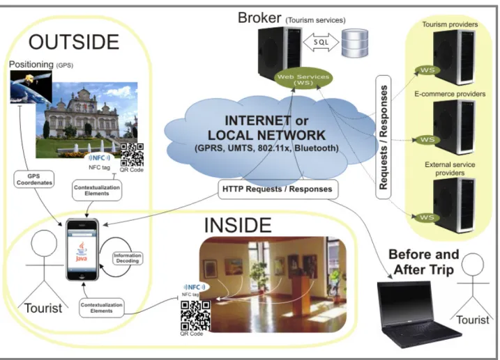
Proposal Framework
Applications for helping tourists “during the trip”, when exists, are mainly focused in a single indexing-technology. Although sometimes one unique contextualization-mechanism can meet the necessary requirements to help tourists, when we only have one technology available, we are limiting the users to problematic situations such: lack of compatible devices with the technology used, or, situations where this technology does not respond in the best way at the requested.
In the case of tourism there are specific situations where we have to use different technologies to satisfy the tourists’ needs. As an example: we can have GPS technology that is very good at tracking and helpful for the establishment of paths and trails for tourists but has an error in the approximation at distances of less than one meter. Also, if the tourist is in a place with many points of interest distancing between them less than one meter of each other and if the technology used to interact with tourists is the GPS, it’s impossible identify which object is to be seen at any given time.
To bridge this gap and the fact that there is no GPS signal indoors (e.g. museums), there are other technologies such as QRCode or NFC tags, that allow a closer interaction with the tourist, that not only have a smaller scope, but also allow only-spreads information to those who request it, being a interaction-aware logic-of-use.
The framework presented in Figure 1, allow insertion and updating of information. The given-nature of information to be incorporated, make the managing information system a PC-based solution. So, besides the integrated system for mobile technologies, there still a part of management and administration system which will link by other means (web) to the server of the application to make the insertion and/or updating the content available to tourists.
The framework, and then a part of providing information to tourists implemented for mobile system using the Java technology to implement the necessary services and technologies required to link the context in which to meet the tourist and have a part accessible from the PC where those who manage the system may change the information available and these changes are propagated in real time to the tourist.
This framework is targeted at mobile devices by integrating multiple mechanisms that background in order to always serve the tourist whatever the circumstance in which he is. Whether it is indoor or outdoor, depending on many conditions to tourist’s contextualization at any given time, the system will always give adequate information to tourists at the time he needs it. To serve the tourist is also aggregated by the external service platform in a common interface and still offers the visitor access via a PC where you can have a range of options available and many times these options do not necessarily have to be consulted during the trip. As an example refer to the ability to book hotel before visiting the site to visit. Any of these external services, whether for the period of travel or off, is obtained through a network of partners, providers of these services and they are made available in the system services provided and the conditions under these services will be provided.
The tourist has on is mobile device a Java application that communicates with the server application to retrieve information when needed, supporting several mechanisms for positioning or contextualization enabling the interaction with the application and obtain relevant information for the tourist.
application, always ensuring the integration of information among the parties and the rapid updating of content available.
Fig 1. Framework Proposal
Conclusion
This century saw an unprecedented increase in the number of users, applications and mobile networks available. The proliferation of mobile devices with increasingly technological features are enabling applications that can render pervasive computing, allowing that information can be accessible anytime and anywhere and, probably, based on user’s location and context (Bahl, et al., 2002).
The proposed framework aims to be an enabler of innovative ways to provide information and services to tourists and establish itself as a gateway to a business network. This work is currently on development stage where we are creating a prototype in order to validate the proposed framework.
References
Abowd, G., Atkeson, C., Hong, J., Long, S., Kooper, R. and Pinkerton, M. (1997) ‘Cyberguide: A mobile context-aware tour guide’, Wireless Networks, 3 (5), 421-433.
ANACOM, (2009), “Serviço Telefónico Móvel - 3º trimestre de 2009”. [Online], [Retrieved April 05, 2010], http://www.anacom.pt/render.jsp?contentId=995208
Apostolopoulos, Y., Leivadi, S. and Yiannakis, A. (1996) The sociology of tourism: theoretical and empirical investigations, Routledge.
Bahl, P., Balachandran, A., Miu, A. K. L., Russell, W., Voelker, G. M. and Wang, Y. (2002) ‘PAWNs: Satisfying the Need for Ubiquitous Connectivity and Location Services,’ IEEE Personal Communications Magazine (PCS), 9 (1).
BBC News Magazine, (2006), “How Do 2D Barcodes Work?”. [Online], [Retrieved April 02, 2010], http://news.bbc.co.uk/2/hi/uk_news/magazine/5362740.stm
Broadbent, J. and Marti, P. (1997) ‘Location Aware Mobile Interactive Guides: Usability Issues’ Fourth International Conference on Hypermedia and Interactivity in Museums (ICHIM97), Paris.
Brown, B. and Chalmers, M. (2003), ‘Tourism and mobile technology’ Proceedings of the eighth conference on European Conference on Computer Supported Cooperative Work.
Cheverst, K., Davies, N., Mitchell, K., Friday, A. and Efstratiou, C. (2000) ‘Developing a context-aware electronic tourist guide: some issues and experiences’ Proceedings of the SIGCHI conference on Human factors in computing systems.
Finkenzeller, K. (2003) RFID Handbook: Fundamentals and Applications in Contactless Smart Cards and Identification 2nd ed., Wiley, Chichester.
Innovision Research & Technology, (2006), “NFC in the Real World - Turning the NFC Promise into Profitable Everyday Applications”. [Online], [Retrieved March 31, 2010], http://www.innovision-group.com/press_view.php?newsID=50
Jones, P. (1999) ‘Operational issues and trends in the hospitality industry’, International Journal of Hospitality Management, 18 (4), 427-442.
Klym, N., Fine, C., Trossen, D. and Tavshikar, M. (2006), “The Evolution of RFID Networks: The Potential for Disruptive Innovation”. [Online], [Retrieved March 31, 2010], http://cfp.mit.edu/groups/core-edge/docs/RFID_Casestudy.pdf
Pospischil, G., Kunczier, H. and Kuchar, A. (2001) ‘LoL@: a UMTS location based service’.
Roberts, C. M. (2006) ‘Radio frequency identification (RFID)’, Computers & Security, 25 (01), 18-26.
Schmidt-Belz, B., Laamanen, H., Poslad, S. and Zipf, A. (2003), Location based Mobile Tourist Services-First User Experiences, Information and Communication Technologies in Tourism 2003, Springer.
Towner, J. (1995) ‘What is tourism’s history?’, Tourism Management, 16 (5), 339-343.
Watson, R., Akselsen, S., Monod, E. and Pitt, L. (2004) ‘The open tourism consortium: laying the foundations for the future of tourism’, European Management Journal, 22 (3), 315-326.
Watson, R.T., Pitt, L.F., Berthon, P. and Zinkhan, G.M. (2002) ‘U-commerce: expanding the universe of marketing’, Journal of the Academy of Marketing Science, 30 (4), 329-343.