Universidade de Lisboa
Faculdade de Ciências
Departamento de Biologia Animal
A low-cost GPS-GPRS telemetry system for otters:
field tests and preliminary data on wild otters
Bruno Herlander Mira Martins
Mestrado em Biologia da Conservação
2010
ii
Universidade de Lisboa
Faculdade de Ciências
Departamento de Biologia Animal
A low-cost GPS-GPRS telemetry system for otters:
field tests and preliminary data on wild otters
Bruno Herlander Mira Martins
Dissertação orientada por:
Prof. Doutor António Mira Prof. Doutora Margarida Santos-Reis
Mestrado em Biologia da Conservação
2010
ii
Acknowledgments
I would like to express my sincere gratitude to everyone that somehow supported me and contributed to this work, and especially to:
My “non official” co-advisor Lorenzo Quaglietta who let me increase my love for animal biology and for the otter world by participating in his PhD “OPA – Otter Project in Alentejo” and, especially, for the supervision of this work, for the support, the concern and all the suggestions and advices that made possible the wrap up of this dissertation even when it seemed unattainable.
Professor António Mira for accepting to be the adviser of this work, for all the expert opinions and for revising the final version of this dissertation.
Professor Margarida Santos-Reis for accepting to be the internal representative and therefore, for the availability with all the bureaucracy process and confidence transmitted along the work.
Addy de Jongh and Tjibee de Jong in the name of the “Dutch Otterstation” for having created and partially sponsirized the GPS devices as well as for their technical and scientific support, during the field work.
All the team from the “OPA” for the help and support to each other, and especially, friendship in all moments, at any time and any place, that will certainly remain the same even after the end of the project.
My family for all the love and care, especially my parents and sister for being always by my side, supporting all my decisions and encouraging me even in my bad mood days, being really helpful to me in overcoming some harder moments.
Ana Rita Tarelho (Kika) for being always present each and every day, for all the love, care and help during the whole work. You are the reason why all things seem easier.
iii And finally, ALL my friends for being always available when I needed them most, even when I was away from home.
iv
RESUMO
Os rios europeus, particularmente os do sul da Europa representam um dos habitats com maior riqueza de espécies que, contudo, continuam a sofrer um acentuado declínio, quase sempre devido a actividades humanas. No que diz respeito às populações de lontra-europeia (Lutra lutra, Linnaeus 1758), sendo um predador de topo destes ecossistemas e com grandes requisitos ecológicos, o impacto sentido nas suas populações, essencialmente pela destruição do seu habitat e consequente diminuição de recursos, é acrescido pela perseguição directa e, cada vez mais, pelo atropelamento acidental.
Actualmente a situação da lontra em Portugal é considerada estável e, ao contrário do que acontece na maioria dos países da sua área de distribuição, este é um dos poucos países da Europa onde ocorrem populações viáveis e com uma distribuição generalizada por todo o território. Este facto atribui a Portugal responsabilidades na conservação e investigação desta espécie, com o objectivo não só, da protecção directa da mesma, mas também da preservação mais eficaz do seu habitat. Esta responsabilidade é acrescida com a necessidade de extrapolação dos conhecimentos adquiridos sobre uma população estável para as regiões onde a sua distribuição é mais restrita.
Deste modo, a necessidade de conhecimento de aspectos importantes acerca da ecologia e da sócio-biologia da lontra-europeia continua a ser essencial no delineamento de uma estratégia de conservação adequada a esta espécie e, apesar do aumento da literatura acerca da mesma ao longo das últimas duas décadas, a informação é ainda bastante escassa. Este resultado, deve-se essencialmente ao comportamento natural das lontras que, como a maioria dos carnívoros, são inactivas durante grande parte do dia e, regra geral, apresentam o pico da sua actividade no período nocturno. Aliado a estas limitações, as lontras são também animais que dependem em grande medida da disponibilidade de água e por isso são
preferencialmente aquáticos, sendo também determinante para a sua distribuição e selecção de habitat, factores como a disponibilidade de recursos, a presença de coberto vegetal com condições de refúgios adequados e a perturbação humana. São por isso animais bastante tímidos e esquivos, o que torna complicado o seu estudo, pois não se consegue facilmente a captura e/ou seguimento eficiente de um número significativo de indivíduos.
Desde o aparecimento do primeiro sistema completo e viável de radiotelemetria, que existe uma ferramenta valiosa para reduzir a falta de informação acerca da lontra. Actualmente a telemetria VHF é a técnica standard utilizada desde o seu aparecimento e uma das metodologias mais utilizadas no seguimento e monitorização da lontra-europeia, bem
v
Resumo
como de outras espécies de lontras. Contudo, desde o desenvolvimento comercial de sistemas de telemetria GPS, que suportam a promessa de melhorar a eficiência e a precisão da telemetria da vida selvagem, que surgiu a necessidade de desenvolvimento desta técnica para aplicação nestes animais. No entanto, os desenvolvimentos a esse respeito nunca foram feitos possivelmente porque, ao contrário de outros animais a aplicação desta tecnologia na lontra apresenta um problema metodológico pela impossibilidade do uso de uma coleira ou de implantação interna, o que exige um método alternativo de fixação externa do dispositivo. Em relação ao desempenho do GPS, a fiabilidade do uso desta nova tecnologia deverá também ser determinada por cuidadosos testes de campo com o dispositivo quanto à precisão e potenciais fontes de erro.
Neste contexto, este estudo propõe-se avaliar a performance, com a lontra-europeia, de um novo sistema de telemetria GPS-GPRS para seguimento de lontras. Os objectivos específicos são quantificar as possíveis fontes de erro, quer pela omissão de dados recebidos quer pela precisão das localizações obtidas com sucesso, bem como descrever a adequabilidade e durabilidade do método alternativo de fixação externa. Por conseguinte pretende-se providenciar informação sobre uma técnica nunca usada anteriormente para a investigação destes animais.
Para alcançar os objectivos propostos, foi inicialmente testado o funcionamento do aparelho bem como a adequabilidade do método de fixação externa, semelhante a uma “mochila GPS”, numa lontra em cativeiro em Maio de 2009. Em seguida, foram realizadas séries de testes estacionários do dispositivo no campo entre Julho e Dezembro de 2009. Durante este período, foram realizados testes tendo em conta actualizações do software do GPS ao longo do estudo e foram identificados outros factores que potencialmente influenciam a obtenção e a precisão de localizações, nomeadamente, o tipo de habitat, a cobertura vegetal ou a submersão do dispositvo na água. Testes mais específicos realizados no habitat rípicola permitiram também testar, para além dos factores anteriormente referidos, outros factores como as condições ambientais, a inclinação do GPS e a posição do mesmo em relação ao leito do rio. Posteriormente, entre Outubro 2009 e Março 2010, seis lontras selvagens foram equipadas com a “mochila GPS” de forma a testar a sua adequação e performance do dispositivo em animais que se movimentavam livremente na natureza.
As probabilidades de obter com sucesso as localizações programadas foram principalmente afectadas pelo efeito da submersão do GPS na água. Este efeito esteve igualmente evidente na precisão das mesmas. As localizações testadas em áreas urbanas apresentaram precisões bastante inferiores em relação aos habitats mais frequentados por estes animais, quer sejam as zonas ripícolas quer as zonas de montado. A actualização do
vi software esteve positivamente associada a um maior sucesso na aquisição de localizações bem como a um aumento evidente da precisão das mesmas. Além de algum efeito negativo causado pela inclinação e pela posição do GPS junto às margens do rio, nos testes nas zonas rípicolas, especialmente em relação à obtenção de localizações, foi novamente o efeito da submersão na água que causou menor taxa de obtenção de dados e menor precisão. No entanto, no geral os resultados obtidos foram bastante satisfatórios, especialmente tendo em conta os resultados finais para a última actualização de software a ser aplicada posteriormente nas lontras selvagens, onde a taxa de localizações obtidas nos testes estacionários programados foi de 63,2% e o erro associado foi <27metros em 95% das localizações. Das seis lontras equipadas com o dispositivo, obtivemos 713 dados com uma taxa de aquisição mais elevada em relação aos testes estacionários (68,2%), mesmo considerando os dois casos onde o GPS não funcionou apropriadamente. O período de acompanhamento de cada animal variou de 4 a 15 dias, para um total de 59 dias. Quanto ao bem-estar animal, em relação à aplicação do método de fixação externo, este provou ser uma boa escolha uma vez que os resultados do seu desempenho foram positivos e não tivemos conhecimento de lesões relacionadas com o equipamento em qualquer lontra monitorizada.
Em suma, os resultados deste estudo permitem propor um novo método de telemetria GPS para lontras, de baixo custo que permite obter um conjunto significativo de informações acerca dos padrões de actividade destes animais. Esta abordagem apresenta-se como uma alternativa vantajosa, permitindo de futuro alargar os conhecimentos existentes sobre esta espécie e consequentemente atingir de maneira mais eficaz os objectivos de conservação propostos para a mesma.
Palavras-chave: baixo custo, lontra, Lutra lutra, mochila GPS, Portugal, precisão, taxa de
aquisição de localizações, telemetria GPS.
viii
SUMMARY
The European otter populations have been suffering a sharp decline especially with the increased pressure on the Riparian habitat causing changes in aquatic systems. Understanding an important element of this ecosystem, as is the Eurasian otter, is an important task in order to raise awareness for wildlife conservation particularly those associated with wetland areas.
The aim of the present study was to evaluate the performance of a new low-cost GPS-GPRS telemetry tracking system on otters Lutra lutra (Linnaeus, 1758). Specifically we aim to assess its bias due to failures in signal acquisition and locations accuracy, as well as report the suitability and durability of a GPS external attachment, and thus to provide information on a new method never used before in otters research.
At a first step, a series of harness stationary field tests concerning the influence of the software updates along the study and several other factors potentially affecting the GPS performance such as habitat type, canopy cover or water submersion were performed. Tests under the particular Riparian habitat testing factors as environmental conditions, GPS inclination and its position on river bed were also analyzed. Later, wild otters were fitted with harnesses to test their suitability and the performance of the GPS device on free ranging animals.
A major negative effect was noticed by the water effect on the fix rate and accuracy of locations. Nevertheless, a software update was positively associated with these data acquisition and precision. The overall performance results were positive on the fix rate success and on accuracy both, on the values of the stationary tests and on the wild otters´ tests.
The development of this technique may give important advances in the way we understand otters’ behavior and space use. Thus, the present study has high importance to the development of methodologies that allow conservation actions to be based on scientifically sound background information.
Keywords: GPS telemetry, accuracy, fix rate, Global Position System (GPS) harness, low-cost, Lutra lutra, otter, Portugal
x
TABLE OF CONTENTS
ACKNOWLEDGEMENTS ………... ii RESUMO ………... iv SUMMARY ……… viii Chapter 1 General Introduction ………. 3 Chapter 2 A low-cost GPS-GPRS telemetry system for otters: field tests and preliminary data on wild otters ……….. 13 2.1 Introduction ………. 13 2.2 Study Area ………... 15 2.3 Methods ………. 16 2.3.1 Equipment Development ……… 16 2.3.2 Field Tests ………... 18 2.3.3 Data Analysis ……….. 202.3.4 Fitting wild otters ………. 20
2.4 Results ………. 21
2.4.1 Equipment development and Field tests ………. 21
2.4.2 Preliminary data on wild otters ……….. 23
2.5 Discussion ………. 25
Chapter 3 Concluding Remarks ……… 37
1
3
General Introduction
Otters in Portugal
In Portugal, the mustelids represent the family of mammals from the carnivores order most diversified and with broad geographic distribution (Nowak 1991). The European Otter (Lutra Lutra Linnaeus, 1758), one of the representatives of this family in the country, is the top predator of our freshwater ecosystems, mainly because it is one of the few European predators that developed the ability to move and feed actively in the water, and so is an important element of biodiversity (Mason and Macdonald 1986, Kruuk 1995, Ruiz-Olmo et al. 2001, Kruuk 2006).
Since the 1950s, the European otter populations have been suffering a sharp decline throughout their wide distribution area (Mason and Macdonald 1986, Macdonald and Mason 1994, Trindade et al. 1998, Kruuk 2006). This is mainly due to the destruction of the riparian vegetation, water pollution and decrease in resources abundance, accidental road kill and hunting (Trindade et al. 1998, Kruuk 2006, Ruiz-Olmo 2008). Currently, it is classified by the International Union for Conservation of Nature (IUCN) with the status of Near Threatened (NT) (Ruiz-Olmo 2008). However, unlike what happens in the majority of the countries of its distribution area, the otter situation in Portugal is considered stable, being one of the most viable in Europe, having this species a widespread distribution throughout the territory (Trindade et al. 1998). Therefore otter is classified according the IUCN categories as Least
Concern (LC) by the Red Book of Vertebrates in Portugal (Queiroz et al. 2005). This assigns increased responsibilities to our country in the conservation and research of this species, aiming not only its direct protection, but also effective conservation of its habitat. This responsibility is enhanced with the need of extrapolating the acquired knowledge from a stable population to others that may be declining in other regions or even to other species of otter.
Despite otters being common in Portugal and the fact that they can be found on small water streams, rivers, dams or even in coastal and estuarine environments (Beja 1989, Trindade et al. 1998, Ruiz-Olmo 2002), they remain largely unknown from the scientific point of view. Nevertheless, it is a very charismatic species and may have an important role in the raise awareness for wildlife conservation, particularly these, associated with wetland areas.
4 The need for knowledge of important aspects of ecology and sociobiology of the otters remains essential in the design of appropriate conservation strategies for these animals and, despite the increased literature about them over the past two decades, the information is still rather scarce (Chanin 2003, Kruuk 2006).
This result is mainly due to the natural behavior of otters that like most carnivores are inactive during much of the day and generally exhibit the peak of its activity at night. Additionally, otters are also mainly aquatic and are very shy and elusive (Chanin 2003, Kruuk 2006), which makes many techniques often used in wildlife studies non-usable, because they cannot be easily captured and/or efficiently monitored with a minimal number of individuals in a human way (Kenward 2001, Powell and Proulx 2003, Harris et al. 2005). Thus, many studies are based on presence/absence of evidences that, despite presenting great limitations, are extremely practical (e.g., Trindade et al. 1998).
Since the first complete and viable system of radio telemetry was design (Cochran and Lord 1963), this provided a valuable tool for increasing knowledge about various aspects of otters life history, making it an obvious choice to fill the gap of information. The advances of this technique made possible the acquisition of detailed data on many aspects of wildlife biology in general, and of the otter in particular, including habitat use, sizes of the vital areas, mortality, survival, migration routes, among others. However, the use of this technique has several requirements that must be taken into account: first, at the humanitarian level because of the invasive nature of these projects; second, at the animal level because they may be subjected to high stress levels or unduly influenced by the capture, marking and tracking techniques and, consequently, they may not show a normal representative behavior of the species. In extreme cases injury or death may be the final result (Resources Inventory Committee 1998, Kenward 2001, Mech and Barber 2002).
Given these considerations, it is clear that planning studies in wildlife telemetry are also of great relevance to conservation and animal welfare. Therefore, along the years, more and more specific guidelines about how to ensure that animals are affected as little as possible during all procedures, have been suggested (Resources Inventory Committee 1998, Kenward 2001, Mech and Barber 2002) allowing the continuous improvement of this research technique.
VHF radio telemetry
The telemetry technique was so revolutionary for the wildlife investigation (Mech 1983) that, despite the need of capturing and marking the animals, up to now there is no other that comes close in relation to its benefits. The VHF radio telemetry is the standard technique
5 used since its appearance in 1963, and has since been applied by different researchers, being currently, the implantation of transmitters into the peritoneal cavity the most used methodology in tracking and monitoring the European otter as well as other species of otters (Saavedra 2002, Poledník 2005, Thomas et al. 2006, Kruuk, 2006, Ó Néil et al. 2008).
The application of this methodology has many practical advantages, including: the wide availability of different materials, allowing its applicability in a wide variety of animals according to their characteristics and research goals; the inherent relatively low cost; the reasonable accuracy of the data obtained for the majority of the desired objectives; and its long duration.
On the other hand, despite its popularity, it also presents several disadvantages. In otters, for instance, it has a strong invasive nature, which requires a qualified veterinarian for the deployment of the device. Moreover, for all species in general it is very labor intensive demanding always the availability of an operator in the field; it often demands long journeys in search of marked individuals, increasing the long-term financial costs of the projects; it is limited to the observation capacity of the full spectrum of activity and behaviors; it is highly influenced by weather conditions, and normally results in a small number of locations in relation to the time spent for obtaining them (Resources Inventory Committee 1998, Mech and Barber 2002).
Nevertheless, at present three types of radio telemetry are available: (1) Very High Frequency (VHF); (2) Satellite Tracking (ST); and Global Position System (GPS); VHF radio telemetry remains at the forefront, being the most versatile, not only to produce animals locations, but also allowing researchers to gather a variety of other types of information (Mech 1980, Mech 1983).
GPS telemetry
Since the commercial development of GPS telemetry systems for monitoring wildlife in 1991, a great variety of configurations were designed for their use by researchers in different situations. In addition, several improvements were made to the size and performance of these systems and despite their costs have dramatically been reduced, they are still often too expensive to be used by the majority of researches that would benefit enormously with the development of alternative GPS devices.
The Global Positioning Systems (GPS) supports the promise of improving the efficiency and accuracy of wildlife telemetry (Rodgers and Anson 1994, Rodgers et al. 1996, Hulbert and French, 2001, Johnson et al. 2002, Urbano 2010) and therefore, are increasingly being used in tracking wildlife and gradually replacing the Very High Frequency (VHF) systems.
6 Although these new systems present high initial costs for its implementation and, at the present, an inferior longevity to the conventional VHF, they have important advantages, including: the shorter time required by the operator for monitoring and tracking the animals; the number of gathered locations is much higher than the one obtained with the VHF system; the flexibility in sampling design, i.e., the locations attempts can be made at intervals set by the user; the high precision of the locations; and the low costs by location (Resources Inventory Committee 1998, Mech and Barber 2002). These characteristics make this system so promising and suitable for studies where intensive and frequent locations are necessary or useful, being fundamental to define new strategies for conservation.
Currently, several studies using GPS collars have shown great success in recording locations, on tracking and monitoring a wide range of species (Johnson 2002, Tomkiewicz et al. 2010). However, the utility of GPS collars varies with the animal, with its habitat and with its behavior. Unlike other animals, the application of this technology on otters has to deal with a methodological issue because a standard collar transmitter is unsuitable, due to the similar diameters of the otter neck and head (Melquist and Hornocker 1979, Kruuk 1995, Zschille et al. 2008). Moreover, the behavioral characteristics of the otter and its habitat become a major challenge to the application of this system on these animals and therefore there are no records in literature on this subject until now. An internal deployment, for the application of this GPS system on otters, is not possible due to the need of an external antenna. The use of an alternative method of external attachment is therefore necessary. To meet this need and avoid the methodological problems, the application of a mounted harness takes priority and while it may be subject of discussion regarding animal welfare and possible associated risks, no significant events are reported in previous studies where they were used on this species (Mitchell-Jones et al. 1984, Ó Néil et al. 2008).
Concerning the GPS performance, these devices were not designed to face dense canopy or repeated water submersion. Several authors have assessed in different studies the effect of many habitat and climate variables, among others, on GPS data acquisition (Rempel et al. 1995, Moen et al. 1996, Dussault et al. 1999, D’Eon et al. 2002, Frair et al. 2004) and location error (Rempel et al 1995, Moen et al. 1996, Hulbert and French 2001, Dussault et al. 2001, D’Eon and Delparte 2005). Many of the variables tested in these studies, that often are part of the otter´s habitat, were reported to influence the GPSs performance (Moen et al. 1997, Rempel and Rodgers 1997, Hulbert and French 2001, Di Orio et al. 2003). So, despite the increasing reliability of these devices, before application on otters, they must be subject to careful field tests for accuracy and potential biases (Edenius 1997, Johnson et al. 2002, Adrados et al. 2003, Gau et al. 2004, Hebblewhite et al. 2010).
7 With a more efficient and practical system to study the ecology, sociology and biology of the European otter and the possibility to use it in other species of otter, we would attain important knowledge to elaborate more efficient measures of conservation and landscape management, in order to better protect not only the otters species but all groups of animals that occur in the same habitats.
In sum, this study aimed assessing the effectiveness of a new GPS-GPRS telemetry tracking system for otters and in this way provided information that can be used in new studies in ecology and biology envisaging the management of this species. The specific objectives were to quantify the number of locations successfully retrieved, their associated error and evaluate potential sources of bias. Additionally, we also wanted to report the suitability and durability of the GPS external attachment.
References
Adrados, C., H. Verheyden-Tixier, B. Cargnelutti, D. Pepin, and G. Janeau. 2003. GPS approach to study fine-scale site use by wild red deer during active and inactive behaviors. Wildlife Society Bulletin 31:544– 553.
Beja, P. 1989. Estudo ecológico de Lutra lutra (Linnaeus, 1758) (Carnivora, Mustelidade) na Costa Sudoeste Portuguesa. Dissertation, University of Lisbon, Lisbon, Portugal. [In Portuguese]
Chanin, P. 2003. Ecology of the European Otter. Conserving Natura 2000 Rivers Ecology Series No. 10. English Nature, Peterborough, U.K.
Cochran, W. W., and R. D. Lord, Jr. 1963. A radio-tracking system for wild animals. Journal of Wildlife Management. 27:9-24
D’Eon, R. G., R. Serrouya, G. Smith, and C. O. Kochanny. 2002. GPS radio telemetry error and bias in mountainous terrain. Wildlife Society Bulletin 30:430–439.
D’Eon, R. G., and D. Delparte. 2005. Effect of radio-collar position and orientation on GPS radio-collar performance, and the implications of PDOP in data screening. Journal of Applied Ecology 42:383–388
Di Orio, A. P., R. Callas, and R. J. Schaefer. 2003. Performance of two GPS telemetry collars under different habitat conditions. Wildlife Society Bulletin 31:372–379.
Dussault, C., R. Courtois, J. P. Ouellet, and J. Huot. 1999. Evaluation of GPS telemetry collar performance for habitat studies in the boreal forest. Wildlife Society Bulletin 27:965– 972.
8
Dussault, C., R. Courtois, J. P. Ouellet, and J. Huot. 2001. Influence of satellite geometry and differential correction on GPS location accuracy. Wildlife Society Bulletin 29:171–179. Edenius, L. 1997. Field test of a GPS location system for moose Alces alces under Scandinavian
boreal conditions. Wildlife Biology 3:39–43.
Frair, J.L., S. E. Nielson, E. H. Merrill, S. R. Lele, M. S. Boyce, R. H. M. Munro, G. B. Stenhouse and H. L. Beyer. 2004. Removing GPS collar bias in habitat selection studies. Journal of Applied Ecology 41:201–212.
Gau, J. R., R. Mulder, L. M. Ciarniello, C. D. Heard, C. D. Chetkiewicz, M. Boyce, R. Munro, G. Stenhiuse, B. Chruszcz, M. L. Gibeau, B. Milakovic, and K. L. Parker. 2004. Uncontrolled field performance of Televilt GPS-Simplex TM collar on grizzly bears in western and northern Canada. Wildlife Society Bulletin 33:693–701.
Harris, S., C. Soulsbury, and G. Iossa. 2005. A scientific review on proposed humane trapping standards in Europe. International Fund for Animal Welfare, Yarmouth Port, Massachusetts, USA.
Hebblewhite, M. and D. T. Haydon. 2010. Distinguishing technology from biology: a critical review of the use of GPS telemetry data in ecology. Philosophical Transactions Of The Royal Society 365, 2303–2312.
Hulbert, I., and J. French. 2001. The accuracy of GPS for wildlife telemetry and habitat mapping. Journal of Applied Ecology 38:869–878.
Johnson, C. J., D. C. Heard, and K. L. Parker. 2002. Expectations and realities of GPS animal location collars: results of three years in the field. Wildlife Biology 8:153–159.
Kenward, R. E. 2001. A manual for wildlife radio tagging. Academic press, London, UK.
Kruuk, H. A. 1995. Wild otters, predation and populations. Oxford University Press, Oxford, UK. Kruuk, H. A. 2006. Otters: ecology, behaviour, and conservation. Oxford University Press,
Oxford, UK.
Macdonald, S. M., and C. F. Mason. 1994. Status and Conservation Needs of the Otter (Lutra lutra) in the Western Palearctic. Nature Environment 67. Council of Europe, Strasbourg, France.
Mason, C.F., and S.M. Macdonald. 1986. Otters: Ecology and Conservation Cambridge. University Press, Cambridge, UK.
Mech, L. D. 1980. Making the most of radiotracking. Pages 85-95 in C. J. Amlaner, Jr, and D. W. Macdonald, editors. A handbook on biotelemetry and radio-tracking. Pergamon Press, Oxford, England.
Mech, L. D. 1983. A Handbook Of Animal Radio-tracking. University of Minnesota Press, Minnesota, USA.
9 Mech, L. D., and S.M. Barber. 2002. A Critique of Wildlife Radio-Tracking and its use in National
Parks, University of Minnesota Press, Minnesota, USA.
Melquist, W. E., M. G. Hornocker. 1979. Methods and techniques for studying and censuring river otter populations. Forest, Wildlife, and Range Experiment Station, Technical Report 8, University of Idaho, Moscow, USA.
Mitchell-Jones, A. J., D. J. Jefferies, J. Twelves, J. Green, R. Green. 1984. A practical system of tracking otters using radiotelemetry and Zn65. Lutra 27:71–74
Moen, R., J. Pastor, Y. Cohen and C. C. Schwartz. 1996. Effects of moose movement and habitat use on GPS collar performance. Journal of Wildlife Management 60:659-668.
Moen, R., J. Pastor, and Y. Cohen. 1997. Accuracy of GPS telemetry collar locations with differential correction. Journal of Wildlife Management 61:530–539.
Nowak, R. 1991. Carnivora: family Mustelidae. Pages 1104-1105 in Walker's Mammals of the World. Fifth edition, Volume 2. Johns Hopkins University Press, Baltimore, USA.
Ó Néil, L., P. Wilson, A. de Jongh, T. de Jong, J. Rochford. 2008. Field techniques for handling, anaesthetising and fitting radio-transmiters to Eurasian otters (Lutra lutra). European Journal of Wildlife Research 54:681-687.
Poledník, L. 2005. Otters (Lutra lutra L.) and fishponds in the Czech Republic: interactions and consequences. PhD thesis, Palacky University, Olomouc, Czech Republic.
Powell, R.A., and G. Proulx. 2003. Trapping and marking terrestrial mammals for research: Integrating ethics performance criteria, techniques, and common sense. ILAR Journal 44:259-276.
Queiroz, A. I., P. C. Alves, I. Barroso, P. Beja, M. Fernandes, L. Freitas, M. L. Mathias, A. Mira, J. M. Palmeirim, R. Prieto, A. Rainho, L. Rodrigues, M. Santos-Reis, M. Sequeira. 2005.
Lutra lutra Lontra. in M. J. Cabral et al. Editors. Livro Vermelho dos Vertebrados de
Portugal, Instituto da Conservação da Natureza, Lisbon, Portugal.
Rempel, R. S., A. R. Rodgers, and K. F. Abraham. 1995. Performance of a GPS animal location system under boreal forest canopy. Journal of Wildlife Management 59:543 – 551.
Rempel, R. S., and A. R. Rodgers. 1997. Effects of differential correction on accuracy of a GPS animal location system. Journal of Wildlife Management 61:525–530.
Resources Inventory Committee. 1998. WildLife Radio Telemetry. Ministry of Environment, Lands and Parks, British Colombia, Canada.
Rodgers, A. R., and P. Anson. 1994. News and applications of the global positioning system. GPS World 5:20–32.
Rodgers, A. R., R. S. Rempel, and K. F. Abraham. 1996. A GPS-based telemetry system. Wildlife Society Bulletin 24:559–566.
10 Ruiz-Olmo, J., J. M. López-Martín, and S. Palázon. 2001. The influence of fish abundance on the otter (Lutra lutra) populations in Iberian Mediterranean habitats. Journal of Zoology 254:325-336.
Ruiz-Olmo, J. 2002. Lutra lutra (Linnaeus, 1758). Pages 278-281 in L. J. Palomo and J. Gisbert editors. Atlas de los Mamíferos Terrestres de España. Dirección General de Conservación de la Naturaleza- SECEM-SECEMU, Madrid, Spain.
Ruiz-Olmo, J., A. Loy, C. Cianfrani, P. Yoxon, G. Yoxon, P. K. de Silva, A. Roos, M. Bisther, P. Hajkova and B. Zemanova. 2008. Lutra lutra. in IUCN 2010, IUCN Red List of Threatened Species. Version 2010.3. (www.iucnredlist.org).
Saavedra, D. 2002. Reintroduction of the Eurasian otter (Lutra lutra) in Muga and Fluvia basins (North-eastern Spain): viability, development, monitoring and trends of the new population. Thesis, Girona University, Barcelone, Spain.
Thomas, A. G., J. D. Erb, B. R. McMillan, and D. J. Martin. 2006. Space use and sociality of river otters (Lontra canadensis) in Minnesota. Journal of Mammalogy 87:740-747.
Tomkiewicz, S. M., M. R. Fuller, J. G. Kie, and K. K. Bates.2010. Global positioning system and associated technologies in animal behavior and ecological research. Philosophical Transactions Of The Royal Society 365, 2163–2176
Trindade, A., N. Farinha, and E. Florêncio. 1998. A distribuição da Lontra Lutra lutra em Portugal - situação em 1995 in Estudos de Biologia e Conservação da Natureza, 28. Instituto da Conservação da Natureza, Lisbon, Portugal. [in Portuguese]
Urbano, F., F. Cangnacci, C. Calenge, H. Dettki, A. Cameron, and M. Neteler. 2010. Wildlife tracking data management: a new vision. Philosophical Transactions Of The Royal Society 365, 2177–2185
Zschille, J., N. Stier, R. Mechthild. 2008. Radio tagging American Mink (Mustela vison) - experience with collar and intraperitoneal implanted transmitters. European Journal of Wildlife Research 54:263–268.
11
13
A low-cost GPS-GPRS telemetry system for otters: field tests and
preliminary data on wild otters
AbstractGlobal positioning system (GPS) telemetry is a technique extensively used on wildlife research worldwide. However, due to its susceptibility to biases resulting from data omission and spatial inaccuracies, rigorous testing is essential especially when new alternative materials are planned to be used. Given the usual budget limitations, the price of equipment is also a priority. A low-cost GPS-GPRS harness system was developed and applied on European otter (Lutra lutra) and the results of its performance in stationary tests and in harnessed free-ranging otters in Central Alentejo region, Portugal are presented here. Initially, several factors that may influence the GPS performance like habitat type, canopy cover and water submersion on GPS fix success rate and accuracy of locations were examined. Then, specifically under the Riparian habitat the effect of environmental variables as well as harness position in the river bed and GPS inclination towards satellite acquisition were also assessed. Additionally, attention was given to the effects caused by the GPS software updates throughout the study. The probability of the GPS successfully acquiring location fixes was mainly affected by water submersion that also affected accuracy, being this last also habitat-dependent. Software update was positively associated with fix success and accuracy of locations. Besides some negative effect of the GPS inclination and position, under the riparian habitat, especially related with the fix acquisition, it was the water submersion that mainly caused fix bias and lower accuracy. Rate of fixes acquired on the programmed stationary scheduled tests for the final software version was 63,2% and location error was <27m for 95% of the locations. Of the 6 GPS harness fitted on otters, 713 locations were stored with a fix rate higher than the stationary testes (68.2%). Monitoring period of each animal lasted from 4 days to 15 days, for a total 59 days. This approach generates reliable information about activity patterns of the otters and as a low-cost method it seems to be a very useful tool in otters´ research.
KEY WORDSaccuracy, fix rate, Global Position System (GPS) harness, GPS telemetry, low-cost, Lutra lutra, otters, Portugal.
2.1 Introduction
The increased availability of Global Positioning System (GPS) devices, due to their continuous technological improvements along with prices’ reduction, is resulting in their increased use in animal tracking (Johnson 2002, Tomkiewicz 2010), slowly replacing Very High Frequency (VHF) telemetry. This is mainly because GPS technologies are expected to improve the efficiency and accuracy of animal locations (Rodgers and Anson 1994,Hulbert and French 2001, Johnson et al. 2002, Urbano 2010). In addition, several improvements made to their size, weight and software capabilities allow new and powerful tracking tools that add higher spatial accuracy of locations, flexibility in sampling design, and often higher cost-effectiveness data acquisition (Rodgers and Anson 1994, Rodgers 2001, Johnson et al. 2002, Adrados et al. 2003, Urbano 2010).
In the last fifty years, the Eurasian otter (Lutra lutra Linnaeus, 1978) worldwide distribution has shown a sharp decline (Mason and Macdonald 1986, Macdonald and Mason 1994, Trindade et al. 1998, Kruuk 2006), and, in spite of its apparent recovery in several countries, its Near Threatened status indicates that conservation concerns still remain for this
14 species (Ruíz-Olmo 2008). Therefore, the need to gain deeper insights into the behavioral ecology of the Eurasian otter as well as of other otter species remains crucial because, besides the increase in literature over the last two decades, the information available is still scarce (Chanin 2003, Kruuk 2006). Currently the VHF radio-tracking, with intraperitoneal implantation of a transmitter, is the most used technique in tracking otter species (Saavedra 2002, Poledník 2005, Thomas et al. 2006, Kruuk 2006, Ó Néil et al. 2008). Due to advantages cited above, the development of GPS devices to track otters could be highly beneficial for studying the ecology of this particularly elusive and shy mammal (Chanin 2003, Kruuk 2006).
Since the abdominal implantation of a GPS device is not possible due to the need of an external antenna, the application of this technology on otters, unlike other animals, has to deal with a methodological constraint, because a standard collar transmitter is unsuitable for otters due to the similar diameters of their neck and head (Melquist and Hornocker 1979, Kruuk 1995, Zschille et al. 2008). The use of an alternative method of external attachment is therefore needed. The application of a mounted harness has been already used (Mitchell-Jones et al. 1984, Ó Néil et al. 2008), although concerns regarding animal welfare and possible risks exist (e.g. Kruuk 2006). However, no significant events are reported in the cited studies, making so far this structure the most reliable possibility for the application of GPS on otters.
Although costs of GPS devices have been reduced in the last years, they are often still too expensive leading to the need of using alternative materials and less expensive techniques in projects constrained by budget limitation.
So far, and into the best knowledge, the performance of GPS devices in wildlife telemetry has never been tested under the peculiar Riparian habitat type, despite the fact that it is one of the most commonly selected habitat types by many taxa (Matos et al. 2009). Nevertheless, several studies have assessed the effect of variables as habitat type, canopy cover, vegetation structure, cloud cover and day period on GPS data acquisition (Rempel et at 1995, Moen et al. 1996, Dussault 1999, D’Eon et al. 2002, Frair et al. 2004) and location errors (Rempel et al 1995, Moen et al. 1996, Hulbert and French 2001, Dussault et al. 2001, D’Eon and Delparte 2005). In this respect, it is known that otters are selective in choosing their habitats that are commonly constituted by dense riparian vegetation (Blanco and González 1992, Ruiz-Olmo 2002, Trindade et al. 1998), and some of these habitat characteristics have been reported to highly influence GPSs performance (e.g. Hulbert and French 2001, Di Orio et al. 2003). Moreover, repeated water submersion may also potentially impede or highly limit the proper functioning of GPS devices. Consequently, before application on otters, the reliability of the use of GPS technologies must be determined by careful field testing, also
15 concerning accuracy and potential biases in such habitat types (Edenius 1997, Johnson et al. 2002, Adrados et al. 2003, Gau et al. 2004, Hebblewhite et al. 2010).
A low-cost, self made GPS-GPRS system was developed, aiming to fit it on otters through mounted harnesses. The device was repeatedly tested under field conditions, in three habitat types including the riparian one. Its design and performance were previously evaluated by mounting it onto an otter in captivity. Finally, for the first time so far, wild otters (Lutra
lutra) were fitted with GPS-harnesses. The main objective of this paper was to assess the rate
of locations acquisition and accuracy of our GPS-GPRS system under urban, open woodland and riparian habitat types. Moreover, a preliminary report on deployment of GPS on Eurasian otters is presented, where advantages and limitations of our GPS-GPRS system are discussed.
2.2 Study Area
Otter situation in Portugal is very favorable with a generalized distribution throughout the country, being the Portuguese otter population considered one of the most stable and viable in Europe (Trindade et al 1998). The current study was conducted from April 2009 to May 2010 in a nuclear area of 1307.04 km² in the central Alentejo Province of Évora, Southern Portugal (Fig 1.). However an additional case occurred outside this area (Fig 1.).The climate is typically Mediterranean (Carmel and Flather 2004), sometimes with Atlantic influence. The annual rainfall is of 600-700 mm but distributed throughout the year unevenly and annual mean temperatures are around 15 - 16 Cº, where the summer is hot and dry and winters are relatively mild and rainy (IMP 2010). The area ranges from 150 to 400 meters high and is mostly plain with smoothed elevations. The dominant land use is the traditional open woodland designated “montado”, predominantly populated by Cork oaks Quercus suber and Holm oaks Quercus ilex combined with extensive agriculture, forestry and livestock grazing (Pinto-Correia 1993). Water courses, dams and several small streams are common, providing an almost continuous water network. However, all rivers, tributaries and creeks have an intermittent character. In the vicinity of the water lines, the riparian vegetation is dominated by brambles Rubus ulmifolius and arboreal vegetation comprising Alders Alnus glutinosa, Poplars Populus nigra and Willows Salix atrocinerea which provide refuge for otters (Beja 1996, Trindade et al 1998, Ruiz-Olmo, 2002). Human settlements are concentrated in cities and farmhouses scattered throughout the landscape.
16
Fig 1. A – Nuclear study area in central Alentejo, Évora. B – CRASSA location.
2.3 Methods
2.3.1 Equipment Development
As GPS transmitter it was used a Telit GE863-GPS, the smallest combined GSM/GPRS (Global System for Mobile Communications/General Packet Radio Service) module in the market available at the time of the study, integrating full 20-channel GPS functionality (Dutch Otterstation Nederland ©). This GPS measured 41.4 x 31.4 x 3.6 mm; on it, a VARTA LiPo battery with 2500 mAh capacity and a GPS antenna were fitted, the total overall dimensions reaching approximately: 70 mm length x 45 mm width x 28 mm thickness for a total weight of 84g or 1.9% of the smallest otter on which the device was applied. These components were encased together with polyethylene foam around them in a transmitter case. The case was made by a shrinkable tube of Thermoplastic Polyofelin sealed through heat to prevent water penetration and provide support and shock protection. Thought to withstand repeated complete immersions in water the encased tube was attached to the leather, the body of the harness, with glue and two stripes of polypropylene tied perpendicularly. A small VHF radio transmitter was added to the GPS unit to ensure that the device would be recovered when it would fall from the animal. Each harness weighted approximately 220g, including the GPS and VHF devices inside the case, and this accounted for 4.8% of the weight of the smallest otter fitted with the device
GPS collars are usually programmed by users to record locations based on the sampling schedule requested and on battery limits. This device was incorporated with a
17
Python ™application script interpreter (Dutch Otterstation Nederland ©) that allowed this functionality and also performed low-consumption cycles (Merrill and Mech 2003, Gau et al. 2004, Cain et al. 2005) on which at each attempt, the unit recorded a location during a 10–380 second period and then turned to a low consumption operation mode.The 2500 mAh battery used had an estimated average life of 42 days providing 4 location records per day.
Three different versions of GPS software were updated during the study period. In all of them, data locations were retrieved by the combined GSM/GPRS service from a pre paid SIM card of any national mobile operator whenever the GSM network was available. Locations were accessed by internet through a page created for this purpose, without the need to recapture the animal or recover the device, allowing also seeing them directly on a Google map. The second version differed from the first one for having a data logger, capable of storing locations whenever GSM network was not available, sending all the recorded information in the subsequent programmed attempt (the first one with good GSM coverage), causing no data lost. Finally, the last version was upgraded with a longer time period for logging of each location. This modification, allowing the search for satellites for a longer time, aimed giving an expected higher accuracy.
Each successful fix provided the following information: geographic coordinates, date, time, battery state, fix status which informs about the acuity of the position fix upon to the number of satellites detected and thetime employed by the unit to log a location.
The harnesses were fitted on otters following the approach of Mitchell-Jones et al. (1984) and Ó Néil et al. (2008). At first, this approach was evaluated on a wild born female otter in captivity in April 2009, at the “Centro de Recuperação de Animais Selvagens de Santo André (CRASSA)” (Fig 1.), in order to allow redefining the best protocol for the wild animals. The harness was fitted to the back of the animal, distributing the weight closer to the animal center of gravity. The neck and chest strips were joint dorsally, to avoid restraining the otter´s movements as well as to keep its abdomen free of restriction (Fig 2.); regarding this, a very conservative approach was adopted regarding the harness mounting operations by not tightening it too much, because of previous concern about the possibility that the otter could drawn if it get entangled.
Harnesses were partly constructed beforehand in order to only activate and fit the GPS in the field, in the lowest time possible. This avoided longer handling periods, enabled turning on the GPS only when animals were caught and also allowed the necessary initial good reception of satellites at open sky.
18 After the first trial onto the otter in captivity, it was realized the need for extra protection of the case, and the tube was covered with a thin layer of Epoxy Adhesive Super Glue for a stronger protection from water, bites or scrape against rocks or bushes (Fig 2.).
Fig 2. A - Captive female otter fitted with the harness in the “Centro de Recuperação de
Animais Selvagens de Santo André”, 2009. B – Wild female otter after the release, in Central Alentejo, 2009. Note the encased tube on the harnesses carrying the Global Positioning System.
2.3.2 Field Tests
During July /December 2009, two series of field tests were performed using the second and third software versions for sessions of 5 and 6 days, respectively. In each session, the GPS harness was placed in test sites above the ground at the same level as an otter or underwater at a mean deep of 0.49±0.26 meters for the water submersion tests (based on direct observation of fishing otters in the study area). All test sites were selected by stratified random sampling (Caughley 1977), from the different typologies of habitat used by otters monitored with VHF radio telemetry within the framework of an extensive ecological project on the behavioral ecology of Eurasian otters in Southern Alentejo “OPA – Otter Project in Alentejo” (L. Quaglietta, PhD thesis, Rome University, in prep.) (Table 1.). During each session, besides taking into account the software versions updates, different variables were also tested like canopy cover, day period and water submersion (Table 1.). Besides that, other variables were also evaluated for tests done specifically under the riparian habitat, including weather conditions (climatic data available by the Geophysics Centre of Évora), GPS inclination towards the sky, GPS position within the river bed and depth at which the device was placed underwater (Table 1.). All these tests were done in order to evaluate the effect on fix success rate and on location error values (table 1.).
Two types of fix success rate were defined: the “GSM success rate” (GSM SR) was computed as the proportion of scheduled locations transmitted by the GSM device even if it
B A
19 resulted in no fix, meaning that the GPS was not able to acquire enough satellites information for computing position coordinates but the GSM service was available to send the data; secondly, the “GPS success rate” (GPS SR) was obtained as the proportion of scheduled telemetry fix attempts that resulted in successful acquisition of a two-dimensional (2D) or three-dimensional (3D) fix, that is, whit an acceptable level of satellite availability (Bowman et al. 2000, D’Eon et al. 2002, Di Orio et al. 2003).
Harness Location Error (HLE) was calculated through the Euclidean distance in meters between each individual test location and the reference or “true position”, established by a portable Garmin eTrex® H with high-sensitivity, WAAS-enabled GPS receiver. For this, it was used the formula [(∆x)2 + (∆y)2]0.5 (Cargnelutti et al. 2007), where ∆x and ∆y are the differences between the true and the observed x and y coordinates, respectively. “Fix accuracy” was given as the error value or degree of closeness of GPS locations to their actual “true” value.
The first software version, used only on the captive otter, was not tested in the field because successive improvements predicted a better final product. Thus, data collected and analyzed from the field tests only included the two latest GPS software versions. The test sessions lasted between 1 and 9 hours (average = 5.54 h), with a scheduled fix attempt of one location every 10 or 20 minutes. In total 390 fix attempts were performed for the field tests, with 85 corresponding to the first update and 305 to the second.
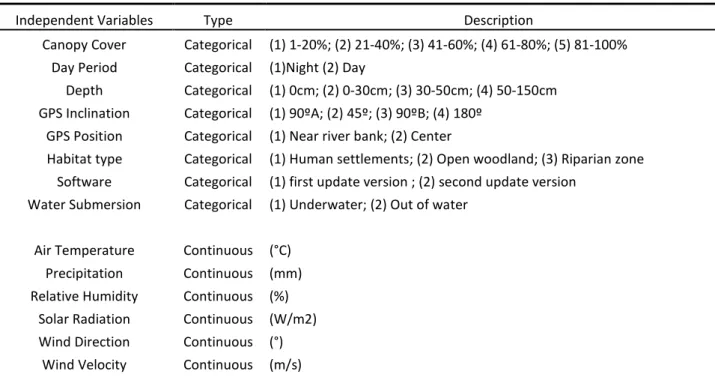
Table 1. Variables used in the evaluation of the GPS performance. Climatic data were provided
by the Geophysics Centre of Évora (http://www.cge.uevora.pt/).
Independent Variables Type Description
Canopy Cover Categorical (1) 1-20%; (2) 21-40%; (3) 41-60%; (4) 61-80%; (5) 81-100% Day Period Categorical (1)Night (2) Day
Depth Categorical (1) 0cm; (2) 0-30cm; (3) 30-50cm; (4) 50-150cm GPS Inclination Categorical (1) 90ºA; (2) 45º; (3) 90ºB; (4) 180º
GPS Position Categorical (1) Near river bank; (2) Center
Habitat type Categorical (1) Human settlements; (2) Open woodland; (3) Riparian zone Software Categorical (1) first update version ; (2) second update version
Water Submersion Categorical (1) Underwater; (2) Out of water Air Temperature Continuous (°C)
Precipitation Continuous (mm) Relative Humidity Continuous (%)
Solar Radiation Continuous (W/m2) Wind Direction Continuous (°)
Wind Velocity Continuous (m/s)
20
Dependent Variables Description
GPS fix success rate Proportion of scheduled fix attempts resulting in successful acquisition (%) HLE Error value of GPS locations to their actual “true” value (m)
2.3.3 Data Analysis
To evaluate first the influence of the variables “Canopy cover”, “Day period”, “Habitat type”, “Water submersion” as well as the “Software” version on the GPS success acquisition, the latter was modeled as a binary response variable (1 - successful location; 0 - unsuccessful location) in a generalized linear mixed-model (GLMM) with a binomial distribution. It was named as “Overall GPS acquisition model” and the date and local of field test trials were used as random terms.
Later, the effects of the same explanatory variables on accuracy of the GPS were addressed by modeling the HLE as a response variable, through a Gaussian GLMM,using only local as random term, because no significant variability was attributed to date on these particular tests. This model was named as “Overall GPS accuracy model”. As an high level of dispersion was noticed in this response variable it was log-transformed.
Finally, to better evaluate the performance of the device under specific otter habitat, two new models of the same type as the previous were built, using only the data acquired by the last GPS version (the one to use later on wild otters) and only under the Riparian habitat. Those two models were named as “Riparian GPS acquisition model” and “Riparian GPS accuracy model” respectively. They allowed better evaluating the GPS performance in the particular riparian habitat and to test new specific variables as “GPS inclination”, “GPS position” within the riverbed, and “Depth” at which the GPS was submerged (table 1). In these models, due to the lower variation in locals used in the field test trials, only date was used as random term.
All variables selected were previously checked for extreme values (potential outliers) and for collinearity. Whenever two variables were collinear, only the ones with more “biological sense” were kept in the analysis. Model selection was performed following Zuur et al. (2009). All the analyses were made using R version 2.11 software (R Development Core Team - 2009).
2.3.4 Fitting wild otters
Once comfortable about harness design and GPS performance, began the fitting of harnesses coupled with the GPS-GPRS device and the small VHF radio transmitter onto wild live-trapped otters between October 2009 and May 2010. GPSs were scheduled to record
21 locations during the night hours, coinciding with the period of major activity by otters (Ruiz-Olmo et al. 2007, Kruuk 2006, L. Quaglietta, unpublished data); eventually, fix schedules may be later adapted to the daily patterns of activity observed and taking into account the GPS functioning in relation to the GSM network coverage.
After releasing the animal, a daily check of the retrieved data was done to see if there was a proper functioning upon the fix rate and to verify if the animal was moving. It was assumed that if harnessed otters were strongly affected, no movements would be detected or some obvious difference in relation to the behavior of otters radiotracked by VHF telemetry in the same project would emerge.
Although it was not necessary for the purpose of downloading data, when harnesses were lost from the otter an attempt to recover them in the field was done, starting the search from the last location received and through the VHF radio fitted in the transmitter case.
Data from all otters marked with GPS harnesses were used to compute the overall GSM and GPS success rate and consequently their reliability in free ranging animals. The durability (days while harnesses remained onto the otters) was accounted from the release of the animals until the moment when it was confirmed that they were able to break free.
2.4 Results
2.4.1 Equipment development and field tests
The initial evaluation upon the harness and the first GPS software version on the wild born otter in captivity was positive. The animal appeared to move naturally and after the first two hours it seemed to behave normally, showing progressively less attention to the device on its back. The HLE, although not measurable in this phase, was estimated by comparison of acquired locations on the map with reference points while the animal was inside the captive facility and appeared to be within a buffer area < 40 meters. After a release process, the GPS worked very satisfactory with all the 66 scheduled locations successfully retrieved and only on 6 it did not acquired enough satellites information to compute position coordinates.
Stationary field test harnesses successfully acquired locations at the different tests sites. From all the 390 attempts, 263 locations were successfully retrieved by the GSM service, giving a GSM SR of 67.4 %. Satellites were successfully acquired in 239 occasions, giving a GPS SR of 61.2%; within these successful locations, 98.8% were 3D fixes and 1.2% 2D fixes. GPSs took an average of 145.2 (SE=112.1) seconds to acquire locations. The Harness Location Error varied widely, from <1meter to 400meters (mean HLE = 19meters), considering both software versions used. However, only in relation to the final software update, the one used afterwards
22 on the wild otters, the observed variance was smaller, from <1meter to 41meters (mean HLE = 8.94) where 50% of locations were within 6meters and 95% were within 27meters.
The average GPS SR of the two software versions used in the field tests was respectively 54.1% and 63.2%. Although the two values were not significantly different, as revealed by a T-test (p=0.0843), a slightly improvement on the GPS SR in the second updated version was notorious. Also concerning the accuracy, a T-test confirms that the latest version performed better, and this time significantly (p=0.0000), with a mean HLE of 8.94 meters (SE= 2.92) compared with the 59.06 meters (SE=5.99) of the first version.
The “Overall GPS acquisition model” revealed a very high significant negative influence of water submersion (p = 0.0004) and software version (p = 0.0100) on GPS SR (table 2). Habitat type and percentage of canopy had no significant effect at any studied circumstance. Nonetheless, the effect of the higher dense canopy, even though not significant, seems to have
a positive trend along the coefficients of this categorical variable (Table 2.). The day period resulted in a non significant effect (p = 0.0842) (Table 2.).
According to the “Overall GPS accuracy model”, the Harness Location Error was significantly lower in the “Open woodland” and “Riparian zones” habitat than in the “Human settlements”. The second software update version greatly improved GPS accuracy (p = 0.0000), unlike water submersion that had a high significant negative effect on the accuracy values (Table 2.). Finally, night period seemed to have a slightly positive effect on HLE accuracy.
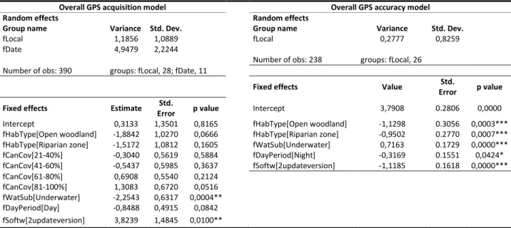
Table 2. Results of the Binomial and Gaussian GLMM models to predict GPS fix success and
accuracy based on all harness tests at respectively 390 sites and 238 sites. The first letter “f” in each variable means factor.
Overall GPS acquisition model Overall GPS accuracy model
Random effects Random effects
Group name Variance Std. Dev. Group name Variance Std. Dev.
fLocal 1,1856 1,0889 fLocal 0,2777 0,8259 fDate 4,9479 2,2244
Number of obs: 238 groups: fLocal, 26
Number of obs: 390 groups: fLocal, 28; fDate, 11
Fixed effects Value Std.
Error p value
Fixed effects Estimate Std.
Error p value Intercept 3,7908 0.2806 0,0000
Intercept 0,3133 1,3501 0,8165 fHabType[Open woodland] -1,1298 0.3056 0,0003*** fHabType[Open woodland] -1,8842 1,0270 0,0666 fHabType[Riparian zone] -0,9502 0.2770 0,0007*** fHabType[Riparian zone] -1,5172 1,0812 0,1605 fWatSub[Underwater] 0,7163 0.1729 0,0000*** fCanCov[21-40%] -0,3040 0,5619 0,5884 fDayPeriod[Night] -0,3169 0.1551 0,0424* fCanCov[41-60%] -0,5437 0,5985 0,3637 fSoftw[2updateversion] -1,1185 0.1618 0,0000*** fCanCov[61-80%] 0,6908 0,5540 0,2124 fCanCov[81-100%] 1,3083 0,6720 0,0516 fWatSub[Underwater] -2,2543 0,6317 0,0004** fDayPeriod[Day] -0,8488 0,4915 0,0842 fSoftw[2updateversion] 3,8239 1,4845 0,0100**
23 Concerning tests done particularly under the Riparian habitat, the “Riparian GPS acquisition model” shows that the “GPS inclination” variable, whatever the angle given to the GPS was, resulted in a fix acquisition significantly worse (Table 2). Also according to this model when the GPS was located near the river bank or underwater, at different depths, its performance was weaker. On the other hand, high levels of solar radiation and air humidity seemed to be related with an increase in the GPS SR.
In the “Riparian GPS accuracy model”, the HLE was mainly limited by water submersion, independently of its depth, and by GPS location near the river bank. No other factors seemed to be relevant on the accuracy values under the riparian habitat.
Table 3. Results of the Binary and Gaussian GLMM models to predict GPS fix success and
accuracy in the Riparian habitat, based respectively on 216 and 137 test sites.
Riparian GPS acquisition model Riparian GPS accuracy model
Random effects Random effects
Group name Variance Std. Dev. Group name Residual Std. Dev.
fDate 26,8360 51,8030 fDate 1,1467 6,1776 Number of obs: 216 groups: dDate, 6 N. of obs: 137 groups: fDate, 6
Fixed effects Estimate
Std.
Error p value Fixed effects Value
Std. Error P value Intercept -11,374705 4,6631 0,0147 Intercept 4,8660 1,4272 0,0009 fPosition[NearRiverBank] -1,511512 0,7059 0,0323* fPosition[NearRiverBank] 4,5606 1,8069 0,0129** fInclination[90ºA] -3,605857 1,8418 0,0503* fDeep[0-30cm] 8,7909 1,8495 0,0000*** fInclination[45º] -3,906528 1,9317 0,0431* fDeep[30-50cm] 8,6080 1,9994 0,0000*** fInclination[90ºB] -3,875649 1,8272 0,0339* fDeep[50-150cm] 7,2067 3,4717 0,0400* fInclination[180º] -3,714997 1,8011 0,0391* fDeep[0-30cm] -4,172830 1,6970 0,0139* fDeep[30-50cm] -3,853845 1,8193 0,0341* fDeep[50-150cm] -3,579300 1,9670 0,0688 SolarRadiation 0,011096 0,0030 0,0002** RelativeHumidity 0,221705 0,0657 0,0007**
2.4.2 Preliminary data on wild otters
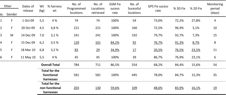
Not considering the wild born captive otter, 6 wild otters were fitted with GPS-GPRS harnesses (Table 4.). Monitoring period of each animal lasted from 4 to 15 days (Table 4.). All otters retrieved data, corresponding to a total of 711 fixes. Four harnesses worked very properly (H1, H2, H3 and H6), being able to obtain all the 581 locations programmed, giving a GSM SR of 100%. Within the retrieved locations, the positional information was successfully
24 acquired 445 times, obtaining a total average GPS SR of 78.0% (Table 4.), with 84.7% in 3D fix and 15.3% in 2D fix. The remaining 2 harnesses (H4 and H5), in spite of having retrieved 130 from the 203 programmed locations (83.9% were 3D fix and 16.1% 2D fix) did not work as supposed, collecting data at irregular times giving an average GPS SR of 48,6% (Table 4.). Likely because of software malfunctioning, the GPS devices have not sent the locations with the requested frequency but instead sent them almost randomly, with the majority of them not corresponding to the programmed scheduled (Table 4.). This however, does not invalidate the quality of these locations.
Table 4. Performance of GPS-GPRS devices fitted on wild otters. The underlined data refers to
the harnesses which did not work properly.
Otter Dates of release Wt (kg) % harness wt No. of Programmed locations No. of Locations retrieved GSM Fix sucess rate No. of Sucessful locations GPS Fix sucess
rate % 3D Fix % 2D Fix
Monitoring period (days) No. Gender 1 F 1 Oct 09 5,5 4 % 74 74 100% 54 73,0% 72,2% 27,8% 4 2 F 20 Oct 09 4,5 4,8 % 221 221 100% 160 72,5% 96,9% 3,1% 10 3 M 14 Dec 09 7,0 3,1 % 241 241 100% 192 79,7% 92,7% 7,3% 15 4 F 15 Dec 09 6,2 3,5 % 120 101 84,2% 92 76,7% 91,3% 8,7% 8 5 F 18 Mar 10 6,8 3,2 % 83 29 34,9% 17 20,5% 76,5% 23,5% 11 6 F 11 May 10 5,5 4 % 45 45 100% 39 86,7% 76,9% 23,1% 6 Overall Total 784 711 86,5% 554 68,2% 84,4% 15,6% 54
Total for the functional harnesses
581 581 100% 445 78,0% 84,7% 15,3% 35
Total for the non functional
harnesses
203 130 59,6% 109 48,6% 83,9% 16,1% 19
Four out of six harnesses (H1, H3, H5 and H6) were recovered from the field. In two cases they were found inside dense bushes constituting otters’ resting sites and in the other two cases on the border of a shallow pool and on the ground between short grass. After being recovered, the harnesses revealed good conditions of the transmitter case (only few minor scratches) with only ventral and dorsal strips weakened by the water, suggesting an easy release by the otters. The harness H2 was recovered with the carcass of the animal killed by humans as revealed by necropsy (L. Quaglietta, unpublished data). It was still in good condition and well suited to the otter’s body so possibly it could have remained attached a few more days. Finally, the harness H4 was lost due to the software malfunctioning and unfortunately was not possible to recover it and, therefore, impossible to better understand what caused the device’s failure. The harnesses recovery allowed also to compute the accuracy of the locations
A low-cost GPS-GPRS telemetry system for otters
25 on real otter places, from the last site where they have lost the harnesses, giving an average HLE value of 4,29meters (n=5).
All animals fitted with GPS harnesses remained in home ranges surrounding the trap sites (Fig 3.), showing space use patterns similar to those of otters monitored by VHF in the same project and area (L. Quaglietta, unpublished data). Importantly, female from harness 5 was recaptured 44 days after she lost the device, being this way possible to document that her body showed no signs of previous injuries and that, more remarkably, she was lactating.
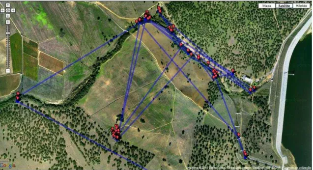
Fig 3. Visualization of the locations obtained by the GPS harness of the male otter monitored
and accessed on the internet directly on map in real time. Note that the red balloons represent each location and the lines that unite them are meaningless, not corresponding to the real course taken by the animal being instead automatically displayed by the software.
2.5 Discussion
The wide applicability and the benefits of GPS technologies in wildlife telemetry are clear (Tomkiewicz 2010, Urbano 2010). However, most tests of GPS performance consider mainly industrial collar devices designed for large mammals. Here, information is provided on the performance of a new manufactured GPS tested under field conditions on natural otter habitat, using a harness designed for this animal.
The performance results from the device on the stationary tests within all habitats in the study area presented, in general, a relatively high failure of the GSM acquisition Success Rate (32.6%) and GPS fix Success Rate (38.8%). These missed fixes were most often affected by