www.adv-geosci.net/27/111/2010/ doi:10.5194/adgeo-27-111-2010
© Author(s) 2010. CC Attribution 3.0 License.
Geosciences
How does climate change affect mesoscale catchments in
Switzerland? – a framework for a comprehensive assessment
N. K¨oplin1,2, D. Viviroli1,2, B. Sch¨adler1,2, and R. Weingartner1,2
1Institute of Geography, University of Bern, Bern, Switzerland
2Oeschger Centre for Climate Change Research, University of Bern, Bern, Switzerland
Received: 2 February 2010 – Revised: 2 June 2010 – Accepted: 9 June 2010 – Published: 28 September 2010
Abstract. Within the framework of this study we identify mesoscale catchments in Switzerland that exhibit sensitivity towards a change in climate with a focus on alterations of the water balance and peak flow conditions. For this study, the hydrological modelling system PREVAH is used, which is a semi-distributed and conceptual yet process-oriented model forced with hourly meteorological input on basis of a spatial resolution of 500×500 m2. We calibrate the model where measured discharge records are available and transfer the cal-ibrated model parameters to ungauged catchments through regionalisation, to arrive at a comprehensive set of model pa-rameters for the entire area of Switzerland. To assess future changes, we apply an extensive set of 16 Regional Climate Models (RCMs) to the catchments. The RCM data are down-scaled to a dense network of meteorological stations for the period from 2021 to 2050 using the Delta Change Approach. This downscaling method incorporates a bias correction of the RCM output and provides change rates and values for precipitation and temperature.
In the present paper we describe the application of a cal-ibration and regionalisation procedure developed previously for Northern Alpine catchments to Southern catchments. The necessity to differentiate between a Northern and a South-ern Alpine region, with their distinct climatologic and phy-siogeographic features, has proved true as the calibrated pa-rameter sets show systematic differences between those re-gions, e.g. for the runoff forming parameters percolation rate (PERC) or storage time for quick runoff (KOH). For the Southern Alpine area, we calibrated two thirds of the avail-able catchments, i.e. 23 out of 36, successfully for standard and flood conditions according to a combined model score of a linear and logarithmic Nash-Sutcliffe-Efficiency (NSE, NSEln) and a mean annual volumetric deviation (VDa). The
Correspondence to:N. K¨oplin (nina.koeplin@giub.unibe.ch)
rate of successfully calibrated catchments is rather small in comparison with the results for the Northern Alpine catch-ments, where 140 out of 159 calibrations have been suc-cessful, and the distribution of the Southern catchments is more irregular. However, as the median NSE and NSElnas
well as the range of VDashow an overall good model fit, a
successful regionalisation may be expected. Next steps are the regionalisation of the Southern Alpine model parame-ters and the application of climate scenarios to the complete set of catchments, i.e. about 200 Swiss mesoscale catch-ments with an average area of 150 km2. Thus we can iden-tify process-based relationships between climate sensitivity and catchment characteristics and provide quantitative infor-mation on future water balance and peak flow conditions of Swiss mesoscale catchments.
1 Introduction
The state of Baden-W¨urttemberg has adapted its Act to Im-prove Preventive Flood Control to the latest findings from the KLIWA project (KLIWA, 2010) that suggests applying a flood adjustment strategy to stave off the consequences of an anticipated climate change. From now on, the determina-tion of design floods has to account for a climate change by adding a climate factor to the HQxx flood runoff (KLIWA,
2006).
112 N. K¨oplin et al.: Climate change impact on Swiss mesoscale catchments frequency of flood events in the last decades just a small
sample of a longer series, where periods with few and fre-quent floods alternate as an analysis by Schmocker-Fackel and Naef (2010) suggests? How will our hydrological sys-tems change in general, if the climate system changes signi-ficantly?
The predominant majority of existing climate change im-pact studies is based on a rather coarse resolution of the employed scenarios both in space and time, in many cases adapted from monthly or seasonal mean values (e.g. Braun et al., 2000; Hagg et al., 2007; Kleinn et al., 2005). More de-tailed investigations, on the other hand, are restricted to mere case studies (e.g. Bultot et al., 1992, 1994; Gurtz et al., 2003; Jasper et al., 2004; Middelkoop et al., 2001; Verbunt et al., 2007).
Impact studies today lack in quantitative assessments of a range of different catchment types, and they also lack in high spatial and temporal resolution of the input data. The latter, particularly, is an essential prerequisite as soon as flood estimation is desired. In addition, so far no study accounts for a change in land cover that a change in climate typically involves, e.g. a decrease of glaciated areas or a shift of tree line.
Our study is unique in terms of examining a broad spec-trum of hydrological systems distributed over the entire area of Switzerland from the lowlands to the high Alpine catch-ments with highly resolved input data and scenarios, and as-sessing not only the impact of a range of climate scenarios, but also a change in land cover, i.e. glaciated and forested area.
2 Study setup and data
The present study is part of the joint research project Climate Change in Switzerland – Hydrology (CCHydro; Volken, 2010), which has been initiated by the Federal Office for the Environment (FOEN) in 2008. Several national research in-stitutions are involved, each of them accounting for a specific aspect of possible climate change impacts on hydrological systems in Switzerland. Within CCHydro, several questions will be investigated in subprojects, concerning the impacts of climate change e.g. on the water balance of Swiss mesoscale catchments and large basins, on the peak flow and low flow conditions, on glacier melt and runoff as well as water tem-perature. Highly resolved scenarios for the hydrologically relevant climate variables are provided, as well as scenarios for glacier retreat and changes in forest cover. These are es-sential input data for the impact studies executed in all sub-projects, which constitutes an added value as the findings will be consistent with respect to the implemented scenarios.
In the subproject that is introduced here, we identify mesoscale catchments exhibiting sensitivity to a change in climate, and quantify the alterations of the water balance and its components, followed by a detailed analysis of the changes in peak flow conditions. We calibrate a
hydrologi-cal model for catchments where measured discharge data is available. However, the number of catchments with uninflu-enced records is limited, due to the high hydropower density in Switzerland (Margot et al., 1992), and their spatial dis-tribution is unbalanced, especially in mountainous regions. Consequently, the model parameters obtained with calibra-tion have to be transferred to ungauged catchments through regionalisation to arrive at a comprehensive set of model pa-rameters for arbitrary mesoscale catchments in Switzerland. Subsequently, the hydrological model is forced with scenario data serving as climate input. This facilitates a quantitative assessment and the identification of catchments that are par-ticularly sensitive to a change in climate. Additionally, land use change scenarios are applied to account for the sensitiv-ity provoked by a change in glaciated area or forest cover.
2.1 Study area
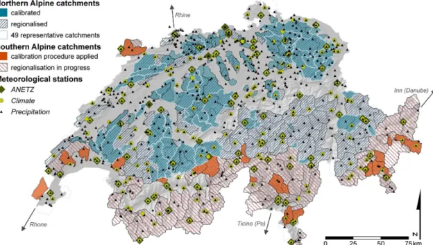
Within the present study, we extend a calibration (Viviroli et al., 2009b) and regionalisation scheme (Viviroli et al., 2009c) which has been developed for and applied to Swiss Northern Alpine catchments in a preceding study to Southern Alpine regions as well (Fig. 1). Southern Alpine catchments are de-fined to be located to the south of the main ridge of the Alps, which incorporates the Inner Alpine valleys in cantons Valais and Grisons, too. To develop the regionalisation procedures, the Southern Alpine catchments were separated from the Northern ones because climatic and geomorphologic char-acteristics differ substantially between those regions, which might have hindered the process.
As soon as we have extended the regionalisation to the Southern Alpine area, a total of about 200 regionalised catch-ments (indicated as blue and red hatched areas in Fig. 1) are available for the application of climate scenarios. With an average area of 150 km2and a range of 30 to 2000 km2they fall into the category of mesoscale catchments. Those lo-cated downstream of larger lakes will not be considered, as their hydrographs are influenced too strongly by lake man-agement. Hence, the slightly irregular distribution of region-alised catchments arises.
2.2 Data base
The required meteorological data are provided by Me-teoSwiss (2008). The variables needed for model forcing are air temperature (◦C), precipitation (mm h−1), relative
hu-midity (%), wind speed (m s−1), global radiation (W m−2)
Fig. 1.Mesoscale catchments for calibration and regionalisation and meteorological network of Switzerland. Those catchments where model parameters were calibrated, validated and regionalised beforehand (Viviroli et al., 2009b,c) are indicated by blue colour, the Southern Alpine catchments presented in this study are shown in red. Note that a few catchments in northwest and west Switzerland belong to the Rhone basin draining southward.
As with the preceding study in the Northern Alpine re-gion by Viviroli et al. (2009b), at least five years of discharge data in hourly resolution are available within the period from 1983 to 2005, which is the case for 36 catchments in the Southern Alpine region. One third of those show quality is-sues, though, which affects their applicability in the present study. The discharge records are provided mostly by the FOEN (2008) and partly by cantonal authorities.
Further input data for the modelling and regionalisation are a digital elevation model as well as maps of land use and soil properties, all of which are provided by the SFSO (2003).
3 Methods
The basics of the methods involved will be explained in this section. A complete documentation of the hydrolog-ical model used is available in Viviroli et al. (2009a), the calibration procedures applied are described by Viviroli et al. (2009b), and Viviroli et al. (2009c) describe the regional-isation scheme developed and tested for the Northern Alpine region.
3.1 Hydrological modelling
The hydrological modelling system PREVAH (Precipitation-Runoff-EVAporation-HRU related model; Viviroli et al., 2009a) is a semi-distributed and conceptual yet process-oriented model that is run on the basis of hourly meteoro-logical input, and at a spatial resolution of 500×500 m2. We
use this model in our study as it has been developed espe-cially to suit conditions in mountainous environments. Fur-thermore, PREVAH has proved to be a reliable and flexible tool for various scopes of application and climate conditions ranging from drought analysis over water balance modelling to flood estimation and forecasting (Viviroli et al., 2009a).
The basic conceptualisation of PREVAH includes an HBV model component (Bergstr¨om, 1976; Lindstr¨om et al., 1997) that is implemented with the semi-distributed approach of hydrological response units (HRUs; Ross et al., 1979; Gurtz et al., 1999). Further modules supplement the model struc-ture, each of which representing an individual process of the hydrological cycle, e.g. interception, soil water storage or snow accumulation and snowmelt as well as glacier melt.
The meteorological station data (Sect. 2.2) have to be in-terpolated, and the spatially distributed meteorological vari-ables are averaged subsequently to 100 m altitude zones to force the model. In this case, interpolation is carried out on the basis of Detrended Inverse Distance Weighting (Viviroli et al., 2007), where detrending is based on elevation depen-dent regression of the climate variables.
3.2 Calibration
114 N. K¨oplin et al.: Climate change impact on Swiss mesoscale catchments
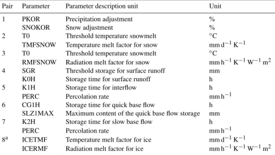
Table 1.Grouping of parameters for successive pair-wise calibration of PREVAH (Viviroli et al., 2009b).
Pair Parameter Parameter description unit Unit
1 PKOR Precipitation adjustment %
SNOKOR Snow adjustment %
2 T0 Threshold temperature snowmelt ◦C
TMFSNOW Temperature melt factor for snow mm d−1K−1
3 T0 Threshold temperature snowmelt ◦C
RMFSNOW Radiation melt factor for snow mm h−1K−1W−1m2 4 SGR Threshold storage for surface runoff mm
K0H Storage time for surface runoff h
5 K1H Storage time for interflow h
PERC Percolation rate mm h−1
6 CG1H Storage time for quick base flow h
SLZ1MAX Maximum content of the quick base flow storage mm
7 K2H Storage time for slow base flow h
PERC Percolation rate mm h−1
8a ICETMF Temperature melt factor for ice mm d−1K−1 ICERMF Radiation melt factor for ice mm h−1K−1W−1m2
aFor glaciated catchments only.
year period within the modelling period from 1983 to 2005 is chosen. Catchments are calibrated using an iterative search algorithm designed to maximize objectivity of the calibration procedure.
A total of 12 tuneable parameters (14 for glaciated catch-ments) are calibrated pairwise and sequentially. An overview of the calibrated parameter pairs is given in Table 1. Every model run is evaluated automatically using a combination of a Nash-Sutcliffe-Efficiency (NSE, Nash and Sutcliffe, 1970) with its logarithmic derivate (NSEln) and a mean annual
vol-umetric deviation (VDa) between observed and simulated
runoff (Viviroli et al., 2009b). In each iteration step per-formed during a calibration, the best model run defines the limits of a reduced parameter space to be tested in the subse-quent step. The tuneable parameters are calibrated for stan-dard and flood conditions, the latter realised through an ad-ditional calibration run and evaluation of peak-flow-sensitive scores (Viviroli et al., 2009b). According to the objectives of our study, both parameter sets (standard and flood calibra-tion) are used for further investigations.
3.3 Regionalisation
The parameter values obtained through calibration are trans-ferred to ungauged catchments subsequently. The region-alisation scheme developed for the Northern Alpine region is a combination of three different approaches of parame-ter regionalisation (Viviroli et al., 2009c), namely Nearest Neighbours (parameter transfer from catchments similar in attribute space), Kriging (parameter interpolation in physical space) and Regression (parameter estimation from relations to catchment attributes).
A total of 82 attributes are collected for every catchment, e.g. geologic, physiographic or hydro-geologic attributes. They were chosen to describe the catchment characteristics best with a view to relevant hydrological, climatological and physiogeographic properties. Sets out of these 82 attributes are used in the individual regionalisation approaches. The resulting hydrographs of each method are combined to one hydrograph by computing their median for each time step. The results are evaluated by cross-validation with the jack-knife-technique (Viviroli et al., 2009c).
3.4 Climate scenarios
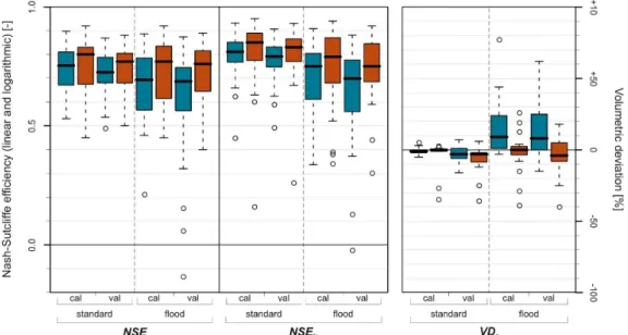
Fig. 2. Box plots for linear and logarithmic Nash-Sutcliffe-Efficiency (NSE, NSEln) and mean annual volumetric deviation (VDa) model scores from 49 representative Northern Alpine (blue boxes, Viviroli et al., 2009b) and 23 Southern Alpine catchments (red boxes) in calibra-tion (cal) and validacalibra-tion (val) periods for standard and flood calibrated parameter sets. Circles denote outliers (distance from upper or lower quartile is greater than 1.5 times the quartile range; Tukey, 1977).
data (measurements and scenarios) for the individual catch-ment to forcing of the calibrated hydrological model. The Institute for Atmospheric and Climate Science (IAC) at ETH Zurich has compiled scenario data for temperature and pre-cipitation as the hydrologically most important climate vari-ables (Bosshard et al., 2009).
A total of 16 RCMs from the ENSEMBLES-project (He-witt and Griggs, 2004) have been interpolated to meteoro-logical station locations and the Delta Change signals have been identified. For each station the mean annual cycle of the Delta Change signal has been calculated for the period from 2021 to 2050 relative to the reference period from 1976 to 2005 with a moving averaging window of 31 days width. In comparison with a commonly used fixed averaging window, e.g. for every month, this allows for a better representation of the annual cycle of the Delta Change signal. Additionally, the annual cycle of the Delta Change has been smoothed with a harmonic model to filter out stochastic signals in the an-nual cycle. The daily Delta values thus calculated are added to (for temperature) or multiplied with (for precipitation) the observed time series to generate a set of climate scenarios with which the model is forced for the individual regionalised catchments.
4 Results and discussion 4.1 Calibration
Within the preceding study for the Northern Alpine region, a total of 140 catchments were calibrated successfully, of which 49 served as representative catchments for extensive evaluation due to their long gauge records covering the
com-plete modelling period from 1983 to 2005 (Viviroli et al., 2009b; see Fig. 1). For the southern region, in contrast, 23 catchments constitute the total set of successfully cali-brated catchments only. Out of the calicali-brated 36 catchments (Sect. 2.2), we had to dismiss 13, due to poor model efficien-cies after calibration. In comparison with the northern catch-ments, where only 19 out of 159 calibrations failed, the pro-portion seems relatively high for the southern region. This can be attributed partly to the abovementioned quality issues with the discharge records, which contain several periods with missing data. Moreover, the interpolation of meteoro-logical station data turned out to be a challenging task, owing to the marked topography in this part of Switzerland and the rather sparse distribution of ANETZ stations. Still, the cali-bration results of the 49 representative Northern Alpine and 23 successfully calibrated Southern Alpine catchments are compared, to assess them for systematic differences between the regions. This information might facilitate the subsequent regionalisation. Furthermore, we are able to verify the appli-cability of the calibration procedure to different climatic or physiogeographic regions.
Without exception, the medians of NSE and NSEln are
116 N. K¨oplin et al.: Climate change impact on Swiss mesoscale catchments
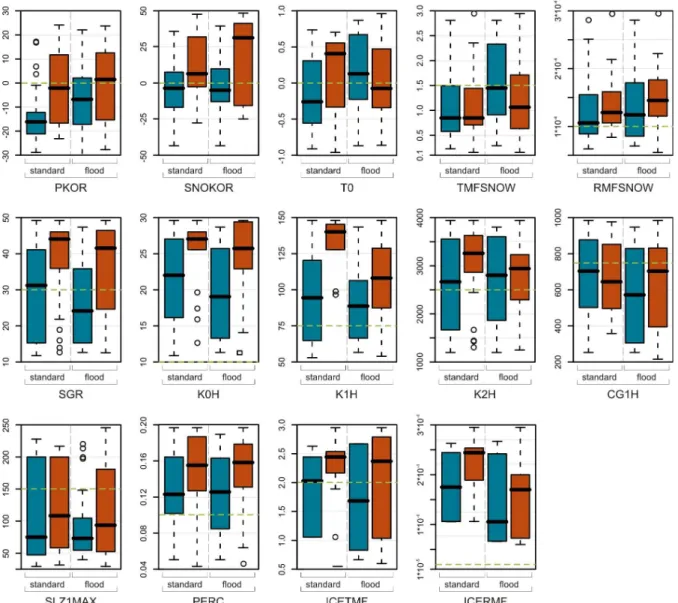
Fig. 3.Box plots for calibrated tuneable model parameters (for acronyms see Table 1) from 49 representative Northern Alpine (blue boxes, Viviroli et al., 2009b) and 23 Southern Alpine catchments (red boxes) for standard and flood calibration mode within the maximum calibration range. The initial value is indicated by a horizontal dashed green line. Circles denote outliers (distance from upper or lower quartile is greater than 1.5 times the quartile range; Tukey, 1977).
with respect to the small number of only 36 catchments for calibration here. This time-consuming procedure, however, was beyond the scope of the previous study by Viviroli et al. (2009b), where an extensive set of 159 catchments was assessed. The comparison of the overall model scores for the Northern and Southern Alpine catchments suggests that the iterative calibration procedure is capable to yield robust pa-rameter estimation for the Southern Alpine region as well. The outliers (Fig. 2) of the Southern Alpine catchments can be attributed to short time series of measured discharge. For the Northern Alpine catchments the outliers are found mainly among small catchments with particularly quick reaction to intense precipitation.
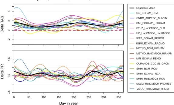
Fig. 4.Annual cycle of the Delta Change Signal for precipitation (PR) and temperature (TAS; Bosshard et al., 2009) using the example of Payerne. The abbreviations in the legend denote the model chain of each RCM as INSTITUTION GCM RCM. For all model chains the SRES emission scenario A1B (IPCC, 2000) was chosen, except for C4I ECHAM RCA where it was A2.
4.2 Climate scenarios
Delta changes are calculated for precipitation and tempera-ture only, as it is the common practice in runoff impact stud-ies (Fowler et al., 2007). Changes in the other hydromete-orological variables needed to force the hydrological model (Sect. 2.2) are not accounted for and will be kept constant when running the model with the climate scenarios, which is a very rough assumption, of course. However, as temper-ature and precipitation are the hydrologically most relevant climate variables, and the most sensitive tuneable model pa-rameters rely on these variables, too, these simplifications are defensible.
The annual cycles of the Delta Change signal for tempera-ture (TAS, Fig. 4) and precipitation (PR) exhibit obvious dif-ferences between the 16 RCMs, which is especially true for the change in precipitation. No clear pattern is observed, ex-cept for a statistically robust increase of autumn precipitation in the Northern Alpine region by about 15 to 25%. Decreas-ing mean precipitation occurs in the summer months and has its largest amplitude of about –15 to –25% in the Western and Southern part of Switzerland. For temperature the pattern is more homogeneous, the increase is strongest in the summer month and for the Alpine regions. The minimum increase can be observed in spring, and no decreasing temperatures are projected (Fig. 4).
5 Conclusion and outlook
In the present study, we introduce a framework in which we will assess the impact of climate change on hydrological sys-tems in Switzerland through hydrological modelling with the semi-distributed and conceptual yet process-oriented PRE-VAH model (Viviroli et al., 2009a). Catchments that are sen-sitive towards a change in climate are determined and the alterations of their water balance and peak flow conditions will be quantified. Land use change scenarios are included in the framework to account for changes of the hydrological systems induced by changes in glaciated and forested area, additionally.
The investigations described in this paper involve the ex-tension of a calibration and validation scheme, which has been developed for Swiss Northern Alpine catchments (Vivi-roli et al., 2009b,c), to Southern Alpine regions as well. Ob-ject of research are about 200 mesoscale catchments with a mean area of about 150 km2, ranging from 30 to 2000 km2. The hydrological model is run at hourly resolution and is forced with spatially and temporally highly resolved climate scenarios from 16 Regional Climate Models, downscaled to meteorological station data using the Delta Approach (Prud-homme et al., 2002).
118 N. K¨oplin et al.: Climate change impact on Swiss mesoscale catchments Viviroli et al. (2009b). The calibrated parameter sets differ
systematically between the Northern and Southern Alpine re-gion, which substantiates the distinction made before. Fur-thermore, this indicates that the calibration procedure is ca-pable of accounting for catchment characteristics found in the Southern Alpine area, too, and yields robust parame-ter estimation. A regionalisation of the model parameparame-ters based on these calibrated catchments, however, we expect to be a challenging task due to the small overall number and their irregular distribution. This likely requires careful re-consideration and extension of the existing regionalisation scheme for the Northern Alpine catchments.
After regionalisation of the model parameters for the Swiss Southern Alpine areas, we will apply the climate narios for the entire area of Switzerland. To check the sce-narios for hydrologic plausibility, we apply them to six test regions first, each of them representing a natural geographic region of the Northern Alps. The results of this plausibility tests will be evaluated, and the scenarios generating physi-cally unreliable results will be excluded from further investi-gations.
On the basis of the previous results, we are confident to identify regions exhibiting climate sensitivity in the period from 2021 to 2050, and specify possible process-based re-lationships between sensitivity and specific catchment char-acteristics. Quantitative information on future water balance and peak flow conditions will be provided. The integration of land use change scenarios, i.e. an alteration of glaciated and forested area, will allow for an additional assessment of land use induced changes of hydrologic systems in Switzerland. As an extensive set of climate scenarios is in use, we will be able to specify the uncertainty range of our findings, too.
Acknowledgements. This study is funded by the Swiss Federal
Office for the Environment (FOEN). The authors would like to thank the FOEN, the Swiss Federal Statistical Office (SFSO) and the Federal Office for Meteorology and Climatology (MeteoSwiss) for providing the necessary input data, as well as Thomas Bosshard (IAC ETHZ) for the calculation of the Delta Change signals.
Edited by: A. Wahren, F. Tavares Wahren, and K.-H. Feger Reviewed by: H. Bormann and another anonymous referee
References
Bergstr¨om, S.: Development and Application of a Conceptual Runoff Model for Scandinavian Catchments, University of Lund, SE, Bulletin Series A, No. 52, 134 pp., 1976.
Bosshard, T., Ewen, T., Kotlarski, S., and Sch¨ar, C.: The annual cycle of the climate change signal – An improved method for use in impact studies, Geophysical Research Abstracts (GRA), 11, EGU2009-7095, 2009.
Braun, L. N., Weber, M., and Schulz, M.: Consequences of climate change for runoff from Alpine regions, Ann. Glaciol., 31, 19–25, 2000.
Bultot, F., Gellens, D., Spreafico, M., and Sch¨adler, B.: Repercus-sions of a CO2doubling on the water balance – A case study in Switzerland. J. Hydrol., 137, 199–208, 1992.
Bultot, F., Gellens, D., Sch¨adler, B., and Spreafico, M.: Effects of Climate Change on Snow Accumulation and Melting in the Broye Catchment (Switzerland), Climatic Change, 28, 339–363, 1994.
FOEN (Federal Office for the Environment): Observed Discharge Time Series of Swiss Rivers, Bern, CH, 2008.
Fowler, H. J., Blenkinsop, S., and Tebaldi, C.: Linking climate change modelling to impacts studies: recent advances in down-scaling techniques for hydrological modelling, Int. J. Climatol., 27, 1547–1578, 2007.
Gurtz, J., Baltensweiler, A., and Lang, H.: Spatially distributed hydrotope-based modelling of evapotranspiration and runoff in mountainous basins, Hydrol. Process., 13, 2751–2768, 1999. Gurtz, J., Zappa, M., Jasper, K., Lang, H., Verbunt, M., Badoux, A.,
and Vitvar, T.: A comparative study in modelling runoff and its components in two mountainous catchments, Hydrol. Process., 17, 297–311, 2003.
Hagg, W., Braun, L. N., Kuhn, M., and Nesgaard, T. I.: Modelling of hydrological response to climate change in glacierized Central Asian catchments, J. Hydrol., 332, 40–53, 2007.
Hewitt, C. D. and Griggs, D. J.: Ensembles-Based Predictions of Climate Changes and Their Impacts, EOS T. Am. Geophys. Un., 85(52), 566, doi:10.1029/2004EO520005, 2004.
IPCC (Ed.): Special Report Emissions Scenarios, Summary for Policymakers, A Special Report of IPCC Working Group III, Geneva, 2000.
Jasper, K., Calanca, P., Gyalistras, D., and Fuhrer, F.: Differential impacts of climate change on the hydrology of two alpine river basins, Clim. Res., 26, 113–129, 2004.
Kleinn, J., Frei, C., Gurtz, J., L¨uthi, D., Vidale, P. L., and Sch¨ar, C.: Hydrologic simulations in the Rhine basin driven by a regional climate model, J. Geophys. Res., 110, D04102, doi:10.1029/2004JD005143, 2005.
KLIWA: Our climate is changing, Consequences-Extend-Strategies, Impact on Water Resources Management in Southern Germany, LUBW “Landesanstalt f¨ur Umwelt, Mes-sungen und Naturschutz” (State Environment, Measurement and Nature Conservation Agency) and “Bayerisches Landesamt f¨ur Umwelt” (Bavarian State Environment Agency, LfU), 2006. KLIWA: http://www.kliwa.de/index.php?pos=\&lang=en, last
ac-cess: 31 January 2010.
KOHS: Auswirkungen der Klima¨anderung auf den Hochwasser-schutz in der Schweiz, Ein Standortpapier der Kommission Hochwasserschutz im Schweizerischen Wasserwirtschaftsver-band (KOHS) (Impact of Climate Change on Flood Protection in Switzerland. A Position Paper of the Commission for Flood Pro-tection of the Swiss Water Resources Society, KOHS), Wasser Energie Luft, 99, 55–57, 2007 (in German).
Lindstr¨om, G., Johansson, B., Persson, M., Gardelin, M., and Bergstr¨om, S.: Development and test of the distributed HBV-96 hydrological model, J. Hydrol., 201, 272–288, 1997.
MeteoSwiss (Federal Office for Meteorology and Climatology): Time Series of Meteorological Variables, Z¨urich, CH, 2008. Middelkoop, H., Daamen, K., Gellens, D., Grabs, W., Kwadijk, J.
C. J., Lang, H., Parmet, B. W. A. H., Sch¨adler, B., Schulla, J., and Wilke, K.: Impact of climate change on hydrological regimes and water resources management in the Rhine basin, Climatic Change, 49, 105–128, 2001.
Nash, J. E. and Sutcliffe, J. V.: River flow forecasting through con-ceptual models part I – A discussion of principles, J. Hydrol., 10, 282–290, 1970.
OcCC: Climate Change and Switzerland 2050, in: Impacts on En-vironment, Society and Economy, OcCC, Bern, CH, 2007. Prudhomme, C., Reynard, N., and Crooks, S.: Downscaling of
global climate models for flood frequency analysis: where are we now?, Hydrol. Process., 16, 1137–1150, 2002.
Ross, B. B., Contractor, D. N., and Shanholtz, V. O.: A finite ele-ment model of overland and channel flow for assessing the hy-drologic impact of land-use change, J. Hydrol., 41, 1–30, 1979. Sch¨adler, B., Frei, C., Grebner, D., and Willi, H. P.: Grundlagen
zum Klima (Climate Fundamentals), Wasser, Energie, Luft, 99, 58–60, 2007 (in German).
Schmocker-Fackel, P. and Naef, F.: More frequent flooding? Changes in flood frequency in Switzerland since 1850, J. Hy-drol., 381, 1–8, 2010.
SFSO (Swiss Federal Statistical Office): GEOSTAT Database Prod-ucts, Licence No. G158000315, ©SFSO, Neuchˆatel, CH, 2003.
Tukey, J. W.: Exploratory data analysis, Addison-Wesley, Reading, MA, 1977.
Verbunt, M., Walser, A., Gurtz, J., Montani, A., and Sch¨ar, C.: Probabilistic Flood Forecasting with a Limited-Area Ensemble Prediction System: Selected Case Studies, J. Hydrometeorol., 8, 897–909, 2007.
Viviroli, D., Gurtz, J., and Zappa, M.: The Hydrological Modelling System PREVAH, Geographica Bernensia P40, Institute of Ge-ography, University of Bern, CH, 2007.
Viviroli, D., Zappa, M., Gurtz, J., and Weingartner, R.: An introduc-tion to the hydrological modelling system PREVAH and its pre-and post-processing tools, Environ. Modell. Softw., 24, 1209– 1222, 2009a.
Viviroli, D., Zappa, M., Schwanbeck, J., Gurtz, J., and Weingart-ner, R.: Continuous simulation for flood estimation in ungauged mesoscale catchments of Switzerland – Part I: Modelling frame-work and calibration results, J. Hydrol., 377, 191–207, 2009b. Viviroli, D., Mittelbach, H., Gurtz, J., and Weingartner, R.:
Con-tinuous simulation for flood estimation in ungauged mesoscale catchments of Switzerland – Part II: Parameter regionalisation and flood estimation results, J. Hydrol., 377, 208–225, 2009c. Volken, D.: CCHydro – Auswirkungen der Klima¨anderung auf