HESSD
10, 3143–3185, 2013Regional and local patterns of bogs and
laggs
S. A. Howie and H. J. van Meerveld
Title Page
Abstract Introduction
Conclusions References
Tables Figures
◭ ◮
◭ ◮
Back Close
Full Screen / Esc
Printer-friendly Version Interactive Discussion
Discussion
P
a
per
|
Dis
cussion
P
a
per
|
Discussion
P
a
per
|
Discussio
n
P
a
per
Hydrol. Earth Syst. Sci. Discuss., 10, 3143–3185, 2013 www.hydrol-earth-syst-sci-discuss.net/10/3143/2013/ doi:10.5194/hessd-10-3143-2013
© Author(s) 2013. CC Attribution 3.0 License.
Geoscientiic Geoscientiic
Geoscientiic Geoscientiic
Hydrology and Earth System
Sciences
Open Access
Discussions
This discussion paper is/has been under review for the journal Hydrology and Earth System Sciences (HESS). Please refer to the corresponding final paper in HESS if available.
Regional and local patterns in depth to
water table, hydrochemistry, and peat
properties of bogs and their laggs in
coastal British Columbia
S. A. Howie1and H. J. van Meerveld2
1
Simon Fraser University, Geography Department, 8888 University Drive, Burnaby, BC, V5A 1S6, Canada
2
VU University Amsterdam, Critical Zone Hydrology Group, De Boelelaan 1085, 1081 HV Amsterdam, The Netherlands
Received: 12 January 2013 – Accepted: 20 January 2013 – Published: 12 March 2013 Correspondence to: S. A. Howie (sarah [email protected])
HESSD
10, 3143–3185, 2013Regional and local patterns of bogs and
laggs
S. A. Howie and H. J. van Meerveld
Title Page
Abstract Introduction
Conclusions References
Tables Figures
◭ ◮
◭ ◮
Back Close
Full Screen / Esc
Printer-friendly Version Interactive Discussion
Discussion
P
a
per
|
Dis
cussion
P
a
per
|
Discussion
P
a
per
|
Discussio
n
P
a
per
|
Abstract
In restoration planning for damaged raised bogs, the lagg at the bog margin is usu-ally not given considerable weight and is sometimes disregarded entirely. However, the lagg is critical for the proper functioning of the restored bog, as it supports the wa-ter mound in the bog. In order to include the lagg in a restoration plan for a raised
5
bog, it is necessary to understand the ecohydrological characteristics and functions of this transition zone. To this end, we studied 13 coastal British Columbia (BC) bogs and identified two different gradients in depth to water table, hydrochemistry, and peat properties: (1) a local bog expanse – bog margin gradient, and (2) a regional gradient related to climate and proximity to the ocean. Depth to water table generally increased
10
across the transition from bog expanse to bog margin, but did not differ regionally. In the bog expanse, pH was above 4.2 in the Pacific Oceanic wetland region (cooler and wetter climate) and below 4.3 in the Pacific Temperate wetland region (warmer and drier climate). Both pH and pH-corrected electrical conductivity increased significantly across the transition from bog expanse to bog margin, though not in all cases. Sodium
15
and magnesium concentrations were generally highest in exposed, oceanic bogs and lower in inland bogs. Ash content in peat samples increased across the bog expanse – bog margin transition, and appears to be a useful abiotic indicator of the location of the bog margin. These gradients highlight both local and regional diversity of bogs and their associated laggs. Knowledge of these gradients is critical if undisturbed bogs are
20
used as templates for the restoration of damaged raised bogs.
1 Introduction
One of the most extensively-studied topics in peatland research is the poor-rich gra-dient (i.e. the continuum from ombrotrophic raised bogs to minerotrophic rich fens) in both vegetation and water chemistry (e.g. Sj ¨ors, 1950; Moore and Bellamy, 1974;
25
HESSD
10, 3143–3185, 2013Regional and local patterns of bogs and
laggs
S. A. Howie and H. J. van Meerveld
Title Page
Abstract Introduction
Conclusions References
Tables Figures
◭ ◮
◭ ◮
Back Close
Full Screen / Esc
Printer-friendly Version Interactive Discussion
Discussion
P
a
per
|
Dis
cussion
P
a
per
|
Discussion
P
a
per
|
Discussio
n
P
a
per
bog expanse – bog margin gradient. This often specifically concerns the mineral soil water limit, which is the boundary between water from only atmospheric sources and mineral soil water. This boundary is often associated with a distinct change in veg-etative communities (Ivanov, 1981; Damman, 1986). Only a few studies have looked at the hydrochemical transition from the bog expanse to the bog margin (e.g. Sj ¨ors,
5
1950; Bubier, 1991; Blackwell, 1992; Mitchell et al., 2008; Richardson et al., 2010). Confounding the ability to conduct research on this transition is a frequent difficulty in locating the lagg, which is the transition zone at the bog margin where water from the bog and the surrounding mineral soil mix and form a vegetative ecotone. This difficulty arises from the variable topography around the margins of raised bogs, and the
re-10
sulting diverse set of transition forms, even around a single bog. Where a topographic depression forms at the margin of a bog, a well-defined lagg ecotone may develop due to a higher groundwater table and mixing of bog water with non-bog water. In other cases, the topographic transition outward from the bog may be less distinct, and veg-etation may change from open bog to forest without a clear lagg ecotone (Howie and
15
van Meerveld, 2011).
The majority of bog studies focus on the central bog expanse; few have included a detailed investigation of the lagg, or have focussed specifically on the bog margin, with the exception of literature related to the development and structure of raised bogs (e.g. Ivanov, 1981; Damman and French, 1987). The lagg is an integral part of the
20
hydrological system of a raised bog because it supports the water mound of the bog and buffers the bog from surrounding minerotrophic water (Schouten, 2002; Damman, 1986). However, marginal zones, such as the lagg, tend to be disturbed first for agri-culture or other development, and are frequently disturbed even for bogs that are in a (near) natural condition in their central parts. A greater understanding of this
tran-25
HESSD
10, 3143–3185, 2013Regional and local patterns of bogs and
laggs
S. A. Howie and H. J. van Meerveld
Title Page
Abstract Introduction
Conclusions References
Tables Figures
◭ ◮
◭ ◮
Back Close
Full Screen / Esc
Printer-friendly Version Interactive Discussion
Discussion
P
a
per
|
Dis
cussion
P
a
per
|
Discussion
P
a
per
|
Discussio
n
P
a
per
|
knowledge about local lagg characteristics also aids in the development of a list of mea-surable lagg indicators (e.g. pH, calcium concentration, ash content of the peat) to be used in restoration strategies or as restoration goals. For example, in the Fraser River delta of British Columbia (BC), government agencies are developing management and restoration plans for several raised bogs; the few small lagg areas that remain in the
5
delta are studied to ensure that this important transition zone is included in restoration planning for the local bogs. As noted by Bragazza et al. (2005), it is not appropriate to compare bogs in geographically distinct regions because they are “not necessarily equivalent from an ecological point of view”. Understanding the regional differences in lagg characteristics is thus needed to ensure an accurate understanding of
ecohydro-10
logical functioning and sound management of the bogs, and bog restoration.
Depth to water table is closely linked to plant community composition. The charac-teristic raised bog vegetation patterns from the bog to the margin consist of (1) central open heath, where a consistently high water table supportsSphagnumand ericaceous shrubs, (2) marginal rand forest, where a lower water table supports tall shrubs and
15
trees, and (3) lagg fen/swamp, where a highly fluctuating water table and mineral soil support fen or swamp vegetation (Damman, 1986). Water level measurements across the bog expanse – bog margin can also provide information about groundwater flow. Outward flow towards the lagg suggests an ombrotrophic raised bog, whereas a mini-mal gradient may indicate a flat bog or poor fen environment.
20
Hydrochemical characteristics also vary across the transition from the bog to the margin. Chemical characteristics are a key parameter in the Canadian System of Wet-land Classification because chemical conditions in peatWet-lands are directly related to precipitation chemistry (oligotrophic peatlands) and groundwater chemistry (eutrophic peatlands) (National Wetlands Working Group – NWWG, 1988). Hydrochemistry also
25
HESSD
10, 3143–3185, 2013Regional and local patterns of bogs and
laggs
S. A. Howie and H. J. van Meerveld
Title Page
Abstract Introduction
Conclusions References
Tables Figures
◭ ◮
◭ ◮
Back Close
Full Screen / Esc
Printer-friendly Version Interactive Discussion
Discussion
P
a
per
|
Dis
cussion
P
a
per
|
Discussion
P
a
per
|
Discussio
n
P
a
per
parameters such as pH, alkalinity, electrical conductivity, and calcium and bicarbon-ate concentrations are sometimes used to determine the boundary between om-brotrophic and minerotrophic conditions at the bog margin (Bragazza and Gerdol, 2002; Bourbonniere, 2009), although this may be a gradual change over several tens of metres without a discrete boundary (Sj ¨ors and Gunnarsson, 2002; Howie and
Tromp-5
van Meerveld, 2011). Cation concentrations (particularly calcium and magnesium), electrical conductivity, and pH generally increase from the bog centre to the bog mar-gin (Bubier, 1991; Bragazza et al., 2005; Richardson et al., 2010), which indicates the increasing influence of minerotrophic water towards the bog margin. Another method used for locating the mineral soil water limit is the Ca : Mg ratio, whereby a ratio less
10
than 1 is often taken as an indication of ombrotrophy (Waughman, 1980; Naucke et al., 1993); however, the specific Ca : Mg ratio at the transition from ombrotrophic to minerotrophic conditions appears to vary regionally and is related to distance from the ocean and annual precipitation (Waughman, 1980; L ¨ahteenoja et al., 2009). This proxy for determining the mineral soil water limit may therefore only be useful where
15
the ratio has been determined for several bogs in the region, as well as for precipitation (Shotyk, 1996).
Closely related to the hydrochemical conditions of a site is the ash content of the peat. The ash content of a peat sample is the amount of non-organic (i.e. mineral) ma-terial in the peat and generally indicates the degree of influence of minerotrophic water
20
(e.g. deposition of sediment from flooding or upland runoff). It may therefore be possible to delineate the lagg area by mapping the ash content of near-surface peat (Bridgham et al., 1996; Rydin and Jeglum, 2006). However, this variable has been cited far less often as an indicator of the mineral soil water limit than gradients in hydrochemistry and vegetation.
25
HESSD
10, 3143–3185, 2013Regional and local patterns of bogs and
laggs
S. A. Howie and H. J. van Meerveld
Title Page
Abstract Introduction
Conclusions References
Tables Figures
◭ ◮
◭ ◮
Back Close
Full Screen / Esc
Printer-friendly Version Interactive Discussion
Discussion
P
a
per
|
Dis
cussion
P
a
per
|
Discussion
P
a
per
|
Discussio
n
P
a
per
|
a clear gradient in surface water chemistry from the outer islands of northern BC to the mainland, where the more oceanic islands were characterized by higher concentra-tions, particularly of sodium and chloride. Riley (2011) observed a positive correlation between pH and distance from the Hudson Bay in central-eastern Canada. In contrast, Glaser et al. (1997) studied raised bogs across northwestern Minnesota (a relatively
5
arid, continental region with no oceanic influences) and found no apparent correla-tion between the westward gradient in precipitacorrela-tion/evapotranspiracorrela-tion and hydrology or water chemistry. Malmer (1986) concluded from a literature review that regional vari-ation in bog vegetvari-ation cannot be attributed to differences in precipitation chemistry, as previously thought, but rather is caused by differences in hydrology, whereby coastal
10
regions have higher annual precipitation and shorter drought periods. These wetter conditions result in higher water tables and the establishment of plant species that tol-erate wet conditions, compared to lower water tables and longer drought periods in continental regions, which support tree growth (Malmer, 1986).
Even though peatlands are common in coastal BC, Canada, due to the cool-moist
15
maritime climate that supports dense vegetation and slows decomposition (NWWG, 1988), research on laggs has been limited to a study of peatlands on Vancouver Island (Golinski, 2004) and Burns Bog in the Fraser River delta (Howie et al., 2009a). Little information exists about regional gradients in bog hydrology and hydrochemistry in coastal BC. The objective of this study was therefore to improve our understanding
20
of the environmental gradients across bog margins, and to determine whether these gradients are consistent for bogs throughout coastal BC.
2 Study locations
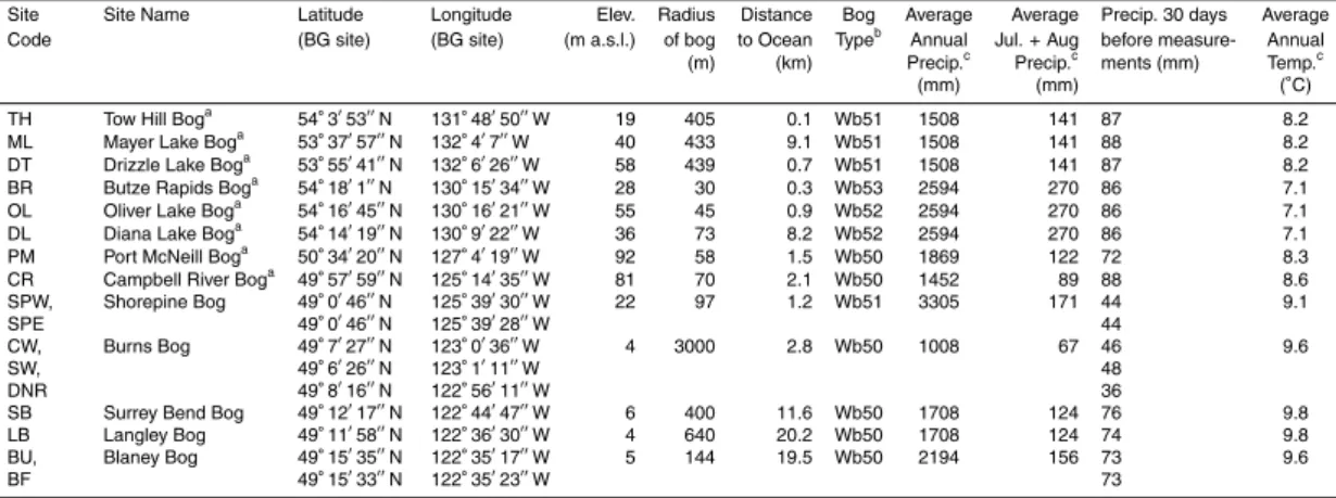
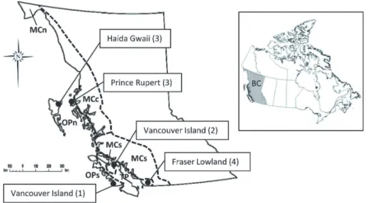
All of the 13 studied bogs are situated along the BC coast between 49 and 54◦N, within 20 km of the Pacific Ocean (including inlets), and are located less than 100 m a.s.l. The
25
HESSD
10, 3143–3185, 2013Regional and local patterns of bogs and
laggs
S. A. Howie and H. J. van Meerveld
Title Page
Abstract Introduction
Conclusions References
Tables Figures
◭ ◮
◭ ◮
Back Close
Full Screen / Esc
Printer-friendly Version Interactive Discussion
Discussion
P
a
per
|
Dis
cussion
P
a
per
|
Discussion
P
a
per
|
Discussio
n
P
a
per
studied in June and July of 2010 and 2011, with the exception of Campbell River and Port McNeill bogs, which were studied in late May 2011 (Table 2).
Wetlands on the Pacific coast of BC fall within two of the seven Canadian wetland regions: Pacific Oceanic and Pacific Temperate (Fig. 1). Canada’s wetland regions are based on broad climatic and vegetation zones, following a north-south temperature
5
gradient and an east-west precipitation gradient (NWWG, 1988). Haida Gwaii and the Prince Rupert area are located within the North Coast subregion of the Pacific Oceanic wetland region. The west coast of Vancouver Island is located in the South Coast sub-region of the Pacific Oceanic wetland sub-region. The North Coast Pacific Oceanic wetland subregion receives the most precipitation (Table 1), resulting in wetlands covering up
10
to 75 % of the landscape; common bog types in this region are slope bogs, basin bogs, and shore bogs (NWWG, 1988). The South Coast Pacific Oceanic wetland subregion is warmer and most bogs are flat bogs or basin bogs. The remainder of the studied bogs are located in the Pacific Temperate wetland region (Fig. 1). Less than 5 % of the landscape in this region is covered by wetlands (NWWG, 1988). The most common
15
types of bog in the Pacific Temperate region are basin bogs and domed bogs.
Three of the studied bogs are located near Prince Rupert (Diana Lake, Oliver Lake, and Butze Rapids). Across Hecate Straight on Graham Island (Haida Gwaii), research was conducted at three bogs (Mayer Lake, Drizzle Lake, and Tow Hill). These six north coast bogs are underlain by acidic basaltic and sedimentary bedrock (NWWG, 1988).
20
Further south on Vancouver Island, studies took place at one bog on the west coast (Shorepine Bog) and two bogs on the east coast (Port McNeill and Campbell River). Shorepine and Campbell River bogs are underlain by sand, whereas Port McNeill bog is underlain by the same basaltic and sedimentary bedrock as the north coast bogs. Four additional bogs were studied in the Fraser Lowland region of southwestern BC.
25
HESSD
10, 3143–3185, 2013Regional and local patterns of bogs and
laggs
S. A. Howie and H. J. van Meerveld
Title Page
Abstract Introduction
Conclusions References
Tables Figures
◭ ◮
◭ ◮
Back Close
Full Screen / Esc
Printer-friendly Version Interactive Discussion
Discussion
P
a
per
|
Dis
cussion
P
a
per
|
Discussion
P
a
per
|
Discussio
n
P
a
per
|
and road construction in Surrey Bend), they are all similar in terms of original form and historic plant communities. The Fraser Lowland bogs represent the southernmost extent ofSphagnum-dominated raised bogs on the west coast of Canada (Vitt et al., 1999).
3 Methods
5
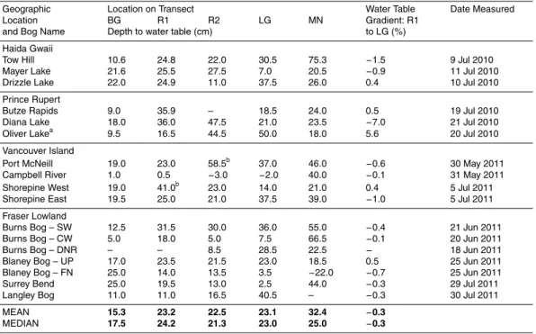
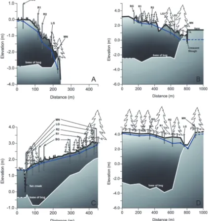
We studied 17 transects consisting of five sampling locations across the laggs of the 13 bogs. Three of the bogs (Shorepine Bog, Burns Bog, and Blaney Bog) contained multiple study transects (Table 1). The five sampling locations on each transect were as follows: (1) inside the bog (“BG”), (2) between the bog and lagg (closer to the bog; “R1”), (3) between the bog and lagg (closer to the lagg; “R2”), (4) approximate centre of
10
the lagg (“LG”), and (5) outside the bog (“MN”) (Fig. 2). Vegetative characteristics were used to determine the five transect locations. BG sites were defined as Sphagnum -dominated heath, LG sites as either Spiraea-dominated or containing larger shrubs and trees than the bog, and MN sites as the forest surrounding the bog. The Burns Bog DNR transect contained no sampling locations between the bog and lagg because
15
of a highway in that transition zone; however, there were two sampling locations in the lagg in order to investigate the differences between two distinct lagg vegetation types, resulting in four sampling locations on the DNR transect. The Burns Bog SW transect also had two sampling locations in the lagg to study differences in lagg vegetation, resulting in a total of six sampling locations on that transect. Butze Rapids bog is very
20
small (60 m diameter), so the transect was shortened to four sampling locations, with only one sampling point between the bog and lagg. All locations were recorded with an Oregon 300 handheld GPS unit, accurate to 5 metres. All transects, except those in Burns Bog, were surveyed with a rod and level; the Burns Bog transect elevations were determined using LiDAR (Light Detection and Ranging) data from September 2008.
25
HESSD
10, 3143–3185, 2013Regional and local patterns of bogs and
laggs
S. A. Howie and H. J. van Meerveld
Title Page
Abstract Introduction
Conclusions References
Tables Figures
◭ ◮
◭ ◮
Back Close
Full Screen / Esc
Printer-friendly Version Interactive Discussion
Discussion
P
a
per
|
Dis
cussion
P
a
per
|
Discussion
P
a
per
|
Discussio
n
P
a
per
a 40 cm slotted section at the bottom. The depth of installation was based on the ob-served water level in the bore holes that were dug prior to piezometer installation. We aimed to place the slotted section of the piezometers as close to the surface of the wa-ter table as possible, while still ensuring an adequate volume of wawa-ter for sample col-lection. The average base of the piezometers was 0.53 m (standard deviation: 0.20 m)
5
below the water table. The piezometers were purged twice and allowed to recharge for a minimum of 24 h, but usually 3–7 days, prior to measuring the water level using an electronic water level probe (Heron Instruments Little Dipper). Previous measurements at Burns Bog showed that the difference in the depth to water level measured with a well (i.e. screening along the entire length) and the depth to water level measured with
10
a piezometer was generally<1 cm and always<2.6 cm. In addition, both the well and the piezometer showed the same temporal pattern. Thus, we assume that the mea-sured depth to water level meamea-sured in the piezometers is representative of the depth to water table (i.e. within 1–2 cm).
Since ombrotrophic bogs receive most (or all) of their water from atmospheric
15
sources, the fluctuation of the water table in bogs is closely linked to precipitation (Egglesmann et al., 1993). For coastal BC bogs, the seasonal rise and fall of the wa-ter table is quite similar between years; the wawa-ter table is highest in winwa-ter, gradually declines through the spring and summer, and is lowest at the end of the summer (i.e. August/September), following the pattern of precipitation in this region (Golinski, 2004;
20
Howie et al., 2009b). Therefore, we measured depth to water table in each bog at roughly the same time of year (June/July) to ensure relatively comparable conditions.
Electrical conductivity and pH were measured at the top 10–15 cm of the water col-umn inside the piezometers with a WTW Multiline P4 water quality meter after allowing the piezometers to recharge after the second purging. Before each measurement, the
25
HESSD
10, 3143–3185, 2013Regional and local patterns of bogs and
laggs
S. A. Howie and H. J. van Meerveld
Title Page
Abstract Introduction
Conclusions References
Tables Figures
◭ ◮
◭ ◮
Back Close
Full Screen / Esc
Printer-friendly Version Interactive Discussion
Discussion
P
a
per
|
Dis
cussion
P
a
per
|
Discussion
P
a
per
|
Discussio
n
P
a
per
|
Water samples were collected for laboratory analysis from all piezometers using a low-flow peristaltic pump (Global Water SP200) and plastic HDPE bottles. The tub-ing of the peristaltic pump was rinsed with water from each new site prior to sample collection in order to avoid contamination. Water was pumped from the piezometers at the rate of recharge whenever possible. Samples were filtered with a 0.45 µm filter
5
within four hours of sample collection in 2010 and in the field in 2011. The water sam-ples for cation analysis were preserved with nitric acid. Samsam-ples were kept on ice and refrigerated until delivery to the Pacific Environmental Science Centre (North Vancou-ver, BC) and were analyzed for the following parameters: Ca2+, Mg2+, Na+, K+, acidity, and dissolved organic carbon (DOC).
10
At each study location along the transect, peat samples were collected at 10, 50, and 100 cm below the surface with an Eijkelkamp flag corer. For each depth, the von Post level of humification was determined in the field using the method described by Rydin and Jeglum (2006). Peat samples from the three depths were wrapped in plastic wrap and sealed in plastic freezer bags for laboratory analysis, transported in a cooler
15
and refrigerated up to one month, or frozen, until laboratory analysis. In the lab, each sample was weighed, oven-dried at 105◦C for 24 h and re-weighed, and then dry-ashed in a 550◦C oven for 24 h and re-weighed a final time to determine the amount of mineral (i.e. non-organic) material in the sample. The depth of peat was recorded at each coring location as well.
20
The measurements were taken in June/July (and late May at Campbell River and Port McNeill) because this was determined to be the most hydrochemically stable time of the year for sampling. Rainfall in coastal BC is generally lowest between May and August; thus, sampling in this period gives the highest probability of avoiding significant rainfall events between purging and sampling that could dilute near-surface pore water
25
HESSD
10, 3143–3185, 2013Regional and local patterns of bogs and
laggs
S. A. Howie and H. J. van Meerveld
Title Page
Abstract Introduction
Conclusions References
Tables Figures
◭ ◮
◭ ◮
Back Close
Full Screen / Esc
Printer-friendly Version Interactive Discussion
Discussion
P
a
per
|
Dis
cussion
P
a
per
|
Discussion
P
a
per
|
Discussio
n
P
a
per
the concentrations of some major cations (e.g. sodium and magnesium) are generally fairly stable over time (Howie and van Meerveld, 2012). For example, in a 1.5-yr study of bogs in southern coastal BC, Howie and van Meerveld (2012) found that pH varied by less than 0.85 and ECcorr varied by less than 88 µS cm−
1
. Measurements in June/July generally were within 0.25 of the long-term average for pH, and within 65 µS cm−1
of
5
the long-term average for ECcorr(85 % of ECcorrmeasurements were within 25 µS cm− 1
of the long-term average) (Howie and van Meerveld, 2012). Bi-weekly and monthly measurements of near surface pore water in an Alberta bog showed that the range in pH was less than 0.5, the range for pH-corrected electrical conductivity was less than 50 µS cm−1, and the range was less than 5mg L−1 for calcium concentration and less
10
than 2 mg L−1for sodium, potassium, and magnesium concentrations (Vitt et al., 1995). Therefore, it was assumed that a one-time sampling event was sufficient to generally characterize the hydrochemistry of the sites.
Spearman rank correlations were used to test the correlation between depth to wa-ter table, the hydrochemical paramewa-ters, or ash content and location on the transect.
15
Pearson linear correlations were used to determine the relation between pH and loca-tion on transect, peat depth, and calcium concentraloca-tion; Spearman rank correlaloca-tions are also shown for these relations. Spearman rank correlations were not performed if the number of observations was less than five. All correlations described in the text are Spearman rank correlations, unless specifically noted as Pearson linear correlations.
20
Spearman rank correlations were also used to determine the correlation between the hydrochemical parameters, peat depth, wetland region, latitude, and annual precipita-tion for the measurements in the BG sites. We used a two tailed t-test to determine if the differences in the measured parameters between the two wetland regions were significant. A significance level of 0.05 was used for all analyses. Tables 3 and 4 also
25
HESSD
10, 3143–3185, 2013Regional and local patterns of bogs and
laggs
S. A. Howie and H. J. van Meerveld
Title Page
Abstract Introduction
Conclusions References
Tables Figures
◭ ◮
◭ ◮
Back Close
Full Screen / Esc
Printer-friendly Version Interactive Discussion
Discussion
P
a
per
|
Dis
cussion
P
a
per
|
Discussion
P
a
per
|
Discussio
n
P
a
per
|
4 Results and discussion
4.1 Depth to water table
4.1.1 Local variation
In coastal BC, one can generally expect to find the water table in hollows of the bog expanse to be within 20 cm of the surface in June and July (Howie and van Meerveld,
5
2012). In this study, the water table was within 25 cm of the surface for all studied BG sites. The depth to water table generally increased across the transition from bog to forest, except in cases where there was a topographic depression that caused water to pond at the bog margin. Depth to water table was smallest for the BG sites (mean: 15 cm below the surface), slightly larger across the transition from bog to lagg (mean
10
for R1, R2, and LG sites: 23 cm), and deepest in the MN sites (mean: 32 cm) (Table 2, Fig. 2a and b). The trend of increasing depth to water table towards the margin of raised bogs is well established (Ingram, 1983; Damman, 1986; Schouten, 2002). However, the variable topography of the individual bogs resulted in this trend being less clear on a site-by-site basis. Spearman rank correlation between depth to water table and
15
position on the transect was significant for only four of 14 transects (three transects had less than five data points and were not included in the analyses) (Table 3). One of the significant correlations was negative (Blaney Bog FN); this transect is located adjacent to a frequently-flooded fen creek, which explains the high water table at the bog margin (Fig. 2c). In other locations (e.g. Mayer Lake, Surrey Bend), the water table was close
20
to the surface in the lagg, due to the lagg being topographically constrained between the bog and an adjacent upland (Fig. 2d).
The (absolute) water table elevation declined from the bog outwards in some cases (10 out of 16 transects), but increased towards the lagg in other cases (6 out of 16 transects). The DNR transect was not included in this analysis because depth to water
25
HESSD
10, 3143–3185, 2013Regional and local patterns of bogs and
laggs
S. A. Howie and H. J. van Meerveld
Title Page
Abstract Introduction
Conclusions References
Tables Figures
◭ ◮
◭ ◮
Back Close
Full Screen / Esc
Printer-friendly Version Interactive Discussion
Discussion
P
a
per
|
Dis
cussion
P
a
per
|
Discussion
P
a
per
|
Discussio
n
P
a
per
and LG sites ranged from 0.1–7.0 % (mean: 1.4 %, standard deviation: 2.0 %) (Table 2). The relatively large positive gradient from bog to lagg at one of the transects (Oliver Lake) may indicate that this bog is either a slope bog or a combination of a flat and a slope bog where the flat bog extends outwards from a basin up the adjacent slope; these types of bogs are common in this part of the study region due to high rainfall and
5
relatively low temperatures (NWWG 1988).
4.1.2 Regional variation
There was no significant difference in early summer depth to water table between the wetland regions (Table 2). The water table in bogs in the Pacific Temperate wetland region was higher overall, but this is likely because most of these bogs were surveyed
10
in late May and June, whereas the bogs in the Pacific Oceanic wetland region were studied in July. In coastal BC, the water table in bogs can be expected to drop 5–10 cm over the month of June, depending on rainfall (Howie et al., 2009b; Howie and van Meerveld, 2012).
The water table was relatively high in MN sites in the Prince Rupert area compared
15
to the other regions. This may be partly explained by the forested slope bogs that are prevalent in the Prince Rupert area. This type of bog is able to persist in this region due to the high annual precipitation and relatively low temperatures (Table 1). The comparatively high water table in the MN sites of Butze Rapids and Diana Lake were likely due to the transects being installed across a transition from open bog to slope
20
HESSD
10, 3143–3185, 2013Regional and local patterns of bogs and
laggs
S. A. Howie and H. J. van Meerveld
Title Page
Abstract Introduction
Conclusions References
Tables Figures
◭ ◮
◭ ◮
Back Close
Full Screen / Esc
Printer-friendly Version Interactive Discussion
Discussion
P
a
per
|
Dis
cussion
P
a
per
|
Discussion
P
a
per
|
Discussio
n
P
a
per
|
4.2 Peat characteristics
4.2.1 Local variation
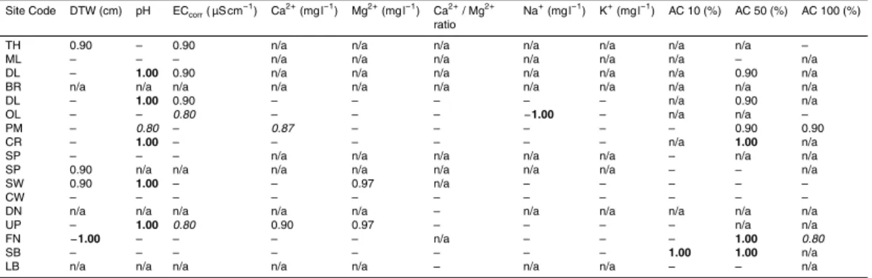
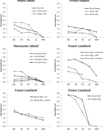
As expected, peat depth decreased from the centre of the bog to the margin for all regions (Fig. 3). There was a significant linear correlation between peat depth and position on the transect for Haida Gwaii, Vancouver Island, and Fraser Lowland bogs,
5
but not for the Prince Rupert bogs, when the transects were combined by region. The linear correlations were significant for 12 of the 17 individual transects. Some MN sites in the Prince Rupert and Fraser Lowland bogs were peaty, whereas all of the MN sites in the Haida Gwaii and Vancouver Island transects were located in mineral soil (Fig. 3). In the Fraser Lowland, this was due to the mineral soil adjacent to the bogs being too
10
rocky to install a piezometer, so the MN study site was instead located in wet, partly organic soil at the margin of the bog. In one transect (Blaney Bog FN), the MN site was located in a large fen at the edge of the bog (Fig. 2c). In Prince Rupert, on the other hand, it is common for open bogs to transition into forested “slope bogs” (NWWG, 1988); the transect at Butze Rapids bog likely cut through this type of transition.
15
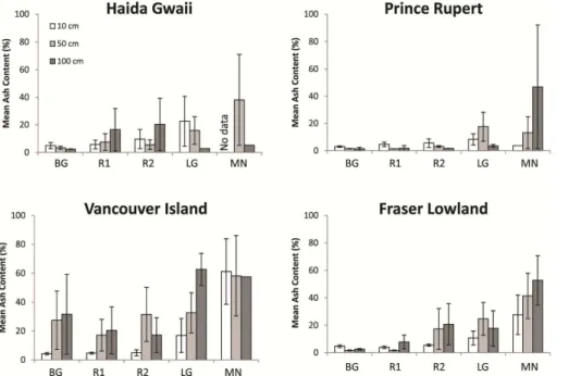
Bog peat normally contains less than 5 % ash content by dry weight, whereas fen peat may have an ash content of up to 35 % (Stoneman and Brooks, 1997; de Vleeschouwer et al., 2010). Our results for BG site peat samples from 10 cm depth generally agreed with these values, except for five bogs (from all regions, except Prince Rupert) that had ash contents between 5–10 %. Peat samples from 50 and 100 cm
20
showed similar results; BG site peat samples contained less than 6 % ash content at 50 cm depth (except for Shorepine Bog) and less than 7 % ash content at 100 cm depth (except for Shorepine Bog). The 50 and 100 cm samples from Shorepine Bog contained significant amounts of sand, which is the substrate beneath the shallow (25 and 60 cm) peat at the two BG sites.
25
HESSD
10, 3143–3185, 2013Regional and local patterns of bogs and
laggs
S. A. Howie and H. J. van Meerveld
Title Page
Abstract Introduction
Conclusions References
Tables Figures
◭ ◮
◭ ◮
Back Close
Full Screen / Esc
Printer-friendly Version Interactive Discussion
Discussion
P
a
per
|
Dis
cussion
P
a
per
|
Discussion
P
a
per
|
Discussio
n
P
a
per
(52 %), and Drizzle Lake bog (58 %). The mean ash content excluding Surrey Bend, Campbell River, and Drizzle Lake was 5 % (standard deviation: 3 %), which falls within the range of ash content of fen peat reported by others. These results are similar to those of Gorham (1950), who found ash content at the outer minerotrophic edge of the lagg of a raised bog near Uppsala to be five times greater than the ash content closer
5
to the centre of the bog.
Ash content was also expected to increase with depth below the surface. However, this was only the case for 44 % of the cores, mostly on Vancouver Island and in the Fraser Lowland. In many cases, ash content was relatively constant, or decreased with depth below surface. Ash content increased with depth twice as often in the LG sites
10
compared to the other locations on the transect. The lagg peat might have received greater amounts of sediment from adjacent upland areas during the accumulation of peat in the bog and lagg. The increasing ash content with depth in the lagg is likely also due to shallower peat in the lagg; the deeper samples were influenced more by mineral soil. Laggs in which the ash content increased with depth had an average peat
15
depth of 0.81 m, whereas laggs where ash content did not increase with depth had an average peat depth of 2.32 m. However, for the other (non-lagg) locations on the transects, depth of peat at the sample site was not related to whether the ash content of the peat cores increased with depth. The most consistent increase in ash content with depth was found for the Shorepine Bog transects; this bog is shallow (<0.8 m) so
20
that the deeper samples were influenced by the sand beneath the peat.
It is generally thought that the level of humification of peat increases with depth below the bog surface (Schouten, 2002), although it has been shown (e.g. Baird et al., 2008) that this trend is not as clear or consistent as might be expected. Our von Post measurements showed a trend of increasing humification with depth in 72 % of the
25
HESSD
10, 3143–3185, 2013Regional and local patterns of bogs and
laggs
S. A. Howie and H. J. van Meerveld
Title Page
Abstract Introduction
Conclusions References
Tables Figures
◭ ◮
◭ ◮
Back Close
Full Screen / Esc
Printer-friendly Version Interactive Discussion
Discussion
P
a
per
|
Dis
cussion
P
a
per
|
Discussion
P
a
per
|
Discussio
n
P
a
per
|
observed that peat from the upper 40 cm of an open bog site was “non-humified”, whereas peat in the upper 20 cm of the adjacent rand forest was “moderately humified”. We found increasing von Post humification from the bog to the lagg in only 33, 60, and 47 % of the transects at 10, 50, and 100 cm depth, respectively. Therefore, von Post humification displayed a more consistent increase with depth than with distance across
5
the transect.
4.2.2 Regional variation
There was a significant difference in peat depth between the Pacific Oceanic and Pa-cific Temperate wetland regions. Peat depth at the BG sites was<0.6 m in the South Coast Pacific Oceanic wetland subregion, and more variable in the North Coast
Pa-10
cific Oceanic wetland subregion (1.1–3.5 m) and Pacific Temperate (1.5–7.6 m) wet-land region. Peat thickness of the Fraser Lowwet-land bogs was generally much greater (average peat depth of BG sites=4.9 m) than those of Haida Gwaii (2.8 m), Prince Rupert (1.7 m) and Vancouver Island (1.2 m). Peat depth was significantly correlated with mean annual precipitation and mean annual temperature. The deepest bogs in our
15
study are located where precipitation is lowest and temperature is highest. In general, the height of raised bogs increases as precipitation increases (Damman, 1979; Clymo, 1984; Ingram, 1983). Our results are not in agreement with this general observation. Bogs also increase in height with increasing mean annual temperature, as long as the water table is high enough thatSphagnum can access water during the growing
sea-20
son (Damman, 1979); our results agree with this observation. However, the height of the peat dome does not only depend on climate, but is also related to the diameter of the bog (Hobbs, 1986; Clymo, 1984; Ingram, 1983). Most bogs in coastal BC are rela-tively small in comparison to those in other areas of Canada, in part due to topographic constraints in this mountainous region (NWWG, 1988). The large bogs of the Fraser
25
HESSD
10, 3143–3185, 2013Regional and local patterns of bogs and
laggs
S. A. Howie and H. J. van Meerveld
Title Page
Abstract Introduction
Conclusions References
Tables Figures
◭ ◮
◭ ◮
Back Close
Full Screen / Esc
Printer-friendly Version Interactive Discussion
Discussion
P
a
per
|
Dis
cussion
P
a
per
|
Discussion
P
a
per
|
Discussio
n
P
a
per
Island, the studied Fraser Lowland and Haida Gwaii bogs are larger (Table 1); the larger diameter of these bogs is likely the main contributing factor to their greater peat depths. We found a significant correlation between bog radius and peat depth (rs=0.58), but not between bog radius and bog height above the lagg (rs=0.50,p=0.082).
Riley (2011) found that peat depth of Hudson Bay peatlands was related to time since
5
glaciation and subsequent isostatic rebound. Coastal British Columbia was glaciated until the end of the Pleistocene (10 000 yr BP); the Cordilleran Ice Sheet covered the mainland and Vancouver Island, whereas Haida Gwaii was covered by its own set of glaciers and large areas may have been ice free (Clague, 1989; Vitt et al., 1990). Some peat deposits in Haida Gwaii predate the end of the last glaciation, supporting
10
the hypothesis that this area was not entirely glaciated (Mathewes and Clague, 1982). Deglaciation in the Prince Rupert area occurred around 12 700±120 BP (Mathewes and Clague, 1982). Sphagnum growth and bog development near Port McNeill oc-curred around 7000 BP as the climate became wetter (Hebda, 1983). The Fraser River delta formed between 7500 and 5000 BP (Clague et al., 1991), and formation of peat
15
in the delta occurred between 5500 and 3500 BP (Hebda, 1977; Clague et al., 1991). Thus, time since last glaciation does not appear to be a primary factor for the observed differences in peat depth in this region.
There was no significant difference in mean ash content at any of the sampled depths for the BG or LG sites between the Pacific Oceanic and Pacific Temperate wetland
re-20
gions. In all 50 and 100 cm LG site peat samples from Prince Rupert and Haida Gwaii, ash content was less than 35 %, except for Drizzle Lake Bog which had 36 % ash content at 50 cm depth (and no sample from 100 cm depth). In contrast, 43 and 81 % of deeper LG site samples from Vancouver Island and the Fraser Lowland, respec-tively, had less than 35 % ash content. The laggs of north coast bogs contain more
25
HESSD
10, 3143–3185, 2013Regional and local patterns of bogs and
laggs
S. A. Howie and H. J. van Meerveld
Title Page
Abstract Introduction
Conclusions References
Tables Figures
◭ ◮
◭ ◮
Back Close
Full Screen / Esc
Printer-friendly Version Interactive Discussion
Discussion
P
a
per
|
Dis
cussion
P
a
per
|
Discussion
P
a
per
|
Discussio
n
P
a
per
|
(prior to dyking) during their development. There was no clear difference in level of von Post humification between the four study regions (Fig. 5).
4.3 Hydrochemistry
4.3.1 Local variation
Pore water pH generally increased across the transects from bog to forest, with the
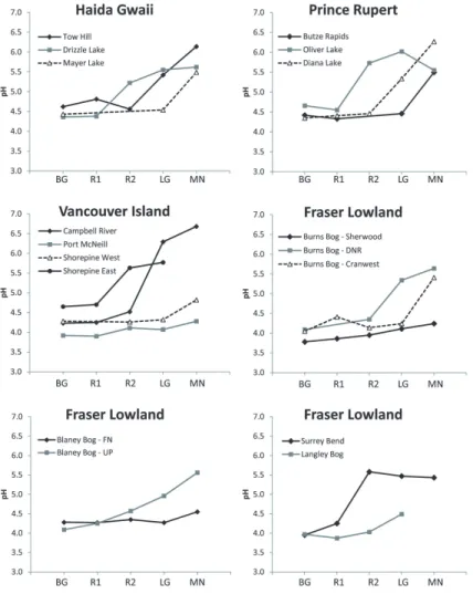
5
lagg pH being transitional between the two ecosystems (Fig. 6). A significant linear correlation between pH and location on the transect was found for all regions when all bogs in a region were analyzed together, but not for all bogs individually. There was a significant correlation between pH and location on the transect for only 5 of the 17 transects (Table 3). Similar to pH, calcium concentrations generally increased across
10
the transition from bog to forest (Fig. 7). However, this correlation was not as consistent or clear as that of pH. The correlation between calcium concentration and position on the transect was only significant for the Prince Rupert and the Fraser Lowland bogs when all bogs in a region were combined, and rarely for individual transects (Table 3). Corrected electrical conductivity (ECcorr) tended to increase across the transects from 15
bog to forest (Fig. 8). There was a significant linear correlation between ECcorr and
location on the transect when bogs were combined by region, except for Vancouver Is-land, but not often for individual transects (Table 3). Mg2+ and Na+ increased from bog to forest for 47 and 35 % of the transects, respectively, and did not appear to be related to position on the transect for the other transects (Table 3). Bubier (1991) found that
20
pH, ECcorr, and Ca
2+ and Mg2+ concentrations increased significantly along a tran-sect from an open bog to a lagg creek in Vermont. Similarly, Bragazza et al. (2005) observed higher pH and concentrations of Ca2+ and Mg2+ in the lagg fens of an Ital-ian and a Swedish bog compared to the open bog expanse. Richardson et al. (2010) found a clear increase in pH at the topographic locations of the laggs derived using
25
HESSD
10, 3143–3185, 2013Regional and local patterns of bogs and
laggs
S. A. Howie and H. J. van Meerveld
Title Page
Abstract Introduction
Conclusions References
Tables Figures
◭ ◮
◭ ◮
Back Close
Full Screen / Esc
Printer-friendly Version Interactive Discussion
Discussion
P
a
per
|
Dis
cussion
P
a
per
|
Discussion
P
a
per
|
Discussio
n
P
a
per
minerotrophic environment for some bogs, the transition of these parameters from the bog to the lagg was neither sharp nor consistent in the coastal BC bogs studied here.
Calcium concentration and pH were not strongly correlated for the BG sites, but were significantly correlated when all sites on all transects were combined (Pearson correlation:r2=0.482; Spearman correlation:rs=0.635). The water samples from the
5
studied sites appear to group into two clusters: (1) pH<4.8, Ca2+<5 mg L−1, and (2) pH>5.0, Ca2+>2.5 mg L−1. Several other researchers have reported a bimodal dis-tribution of pH, where bog pH is less than 4.5–5.0 and fen pH is higher than 5.5–6.0 (Wheeler and Proctor, 2000; Bourbonniere, 2009). “Cluster 1” is representative of typ-ical bog chemistry, whereas “Cluster 2” is representative of fen or minerotrophic water
10
(MacKenzie and Moran, 2004; Bourbonniere, 2009). All of the water samples from the BG and R1 sites belong to Cluster 1, whereas the remainder of the transect points were split between Cluster 1 and Cluster 2: 71 % of R2 samples, 53 % of LG samples, and 27 % of MN samples are part of Cluster 1. Due to the proximity of LG sites to ad-jacent and underlying minerotrophic soils, one would expect most of the LG sites to fall
15
within Cluster 2, but in fact, about half of the LG sites fell within Cluster 1. A possible explanation is that the Cluster 1 LG sites were more affected by bog water than Cluster 2 LG sites, which would explain the lower pH in Cluster 1 LG sites. The topographic evidence for this hypothesis, however, is not strong; 4 out of 10 of the Cluster 1 laggs, and 5 out of 9 of the Cluster 2 laggs, were higher in elevation than the adjacent bog
20
sites, so could not receive much surface runofffrom the bog. The water table elevation at 8 out of the 10 LG sites in Cluster 1 was lower than at the BG sites on the same transect, suggesting subsurface flow towards the lagg. However, subsurface flow to-wards the lagg likely occurred in the other bogs at other times as well (e.g. in winter when water tables are higher). Another reason for the high number of LG sites in
Clus-25
HESSD
10, 3143–3185, 2013Regional and local patterns of bogs and
laggs
S. A. Howie and H. J. van Meerveld
Title Page
Abstract Introduction
Conclusions References
Tables Figures
◭ ◮
◭ ◮
Back Close
Full Screen / Esc
Printer-friendly Version Interactive Discussion
Discussion
P
a
per
|
Dis
cussion
P
a
per
|
Discussion
P
a
per
|
Discussio
n
P
a
per
|
content of Cluster 1 LG peat was only 20 % of the mean ash content of Cluster 2 LG peat at 10 cm depth, and 70 % of the mean ash content of Cluster 2 LG peat at 50 cm depth. Thus, it appears that ash content of the lagg peat may have a stronger influ-ence on the chemical composition of pore water during the drier summer months of the study period than topographic position or peat depth in the lagg. Ash content
there-5
fore appears to be a useful indicator of the change from ombrotrophic to minerotrophic conditions.
A Ca : Mg ratio greater than 1–2 has been proposed as a possible indicator of the mineral soil water limit (Waughman, 1980; Naucke et al., 1993; Bragazza and Gerdol, 1999). For example, Bragazza et al. (2005) found a sharp increase in the Ca : Mg ratio
10
from the bog expanse to the minerotrophic margin in an Italian and a Swedish bog. In our study, the Ca : Mg ratio did not consistently indicate the mineral soil water limit; only 8 out of the 17 transects (47 %) showed an increase in the Ca : Mg ratio from bog to forest. None of the correlations between the Ca : Mg ratio and position on the transect were statistically significant (Table 3).
15
4.3.2 Regional variation
For the BG sites, pH of near-surface pore water decreased significantly with increasing peat depth (Fig. 9); pH also increased with latitude and mean annual precipitation, but these trends were not significant (p=0.064 and 0.066, respectively). Acidity was also significantly correlated with peat depth and latitude, due to its correlation with pH
20
(Table 3). Riley (2011) found a similar relation between pH and latitude for bogs of the Hudson Bay Lowlands, and noted that pH was above 4.0 in bogs with peat depths less than 1.5 m. Riley attributed the geographic variation in pH to isostatic rebound over the past 5500 yr, whereby the land that emerged first has the deepest peat and the lowest pH. Shallower bogs are thought to have a higher pH due to greater nutrient contribution
25
HESSD
10, 3143–3185, 2013Regional and local patterns of bogs and
laggs
S. A. Howie and H. J. van Meerveld
Title Page
Abstract Introduction
Conclusions References
Tables Figures
◭ ◮
◭ ◮
Back Close
Full Screen / Esc
Printer-friendly Version Interactive Discussion
Discussion
P
a
per
|
Dis
cussion
P
a
per
|
Discussion
P
a
per
|
Discussio
n
P
a
per
A regional bimodal distribution in pH was found for the BG sites. For the eight tran-sects in the Pacific Oceanic wetland region (north and south coast subregions), pH in the BG sites was above 4.2; for the nine transects in the Pacific Temperate wetland region, pH was below 4.3 (Fig. 9). The difference in pH between the Pacific Oceanic and Pacific Temperate wetland regions is statistically significant. This difference may
5
be explained by the differences in peat depth, as described above. Another possible explanation is the difference in mean annual rainfall between the two wetland regions: average of 2117 mm yr−1for the Pacific Oceanic region and 1044 mm yr−1 for the Pa-cific Temperate region (NWWG, 1988). In July and August, the studied PaPa-cific Oceanic bogs receive, on average, approximately 60 % more rainfall than the studied Pacific
10
Temperate bogs (Table 1). On average, the studied bogs in the Pacific Oceanic wetland region received 76 mm (standard deviation: 19 mm) of rainfall in the month preceding sampling; the bogs in the Pacific Temperate wetland region received 65 mm (standard deviation: 17 mm) in the month prior to sampling. Higher rainfall in the Pacific Oceanic wetland region may dilute near-surface pore water so that it is less acidic and more
15
similar to rainwater, even in summer. The drier and warmer conditions in the Pacific Temperate wetland region likely result in greater evapotranspiration and concentration of bog water, thereby lowering the pH of near surface pore water. Measurements were taken on different dates and under a variety of weather conditions, leading to some variability due to the time of sampling. However, pH of near-surface pore water tends
20
to have a high temporal stability in bogs and measurements were taken in May–July when the concentration effect due to evapotranspiration isn’t as pronounced as it is in later summer (Howie and van Meerveld, 2012; Vitt et al., 1995; Wieder, 1985). Howie and van Meerveld (2012) showed for two bogs in the Fraser Lowland that pH measured in June was within 0.25 of the mean pH.
25
HESSD
10, 3143–3185, 2013Regional and local patterns of bogs and
laggs
S. A. Howie and H. J. van Meerveld
Title Page
Abstract Introduction
Conclusions References
Tables Figures
◭ ◮
◭ ◮
Back Close
Full Screen / Esc
Printer-friendly Version Interactive Discussion
Discussion
P
a
per
|
Dis
cussion
P
a
per
|
Discussion
P
a
per
|
Discussio
n
P
a
per
|
precipitation annually than those in Haida Gwaii, the low ionic concentrations could be a result of the high rainfall but are likely also caused by differences in precipitation chemistry. Vitt et al. (1990) studied bogs on Haida Gwaii (Graham Island) and in the Prince Rupert area, and similarly found that sodium and chloride (and, to a lesser ex-tent, magnesium) were much higher on Haida Gwaii than in Prince Rupert and islands
5
to the south of Prince Rupert. They attributed this variation to a coastal-inland gradient of decreasing concentrations of cations and anions, particularly sodium and chloride, with distance from the coast. Malmer et al. (1992) reported a similar gradient in surface water chemistry of peatlands across western Canada, including Haida Gwaii and the Prince Rupert area. He found that sodium, magnesium, and chloride concentrations
10
were approximately 9, 8, and 7 times higher, respectively, in Haida Gwaii bogs than in Prince Rupert bogs. It is well established that the ionic concentrations in surface water of ombrotrophic bogs reflect local precipitation (Gorham, 1955; Proctor, 1995), so the clear difference in ion concentrations between Haida Gwaii and Prince Rupert bogs can most likely be attributed to higher ion concentrations in precipitation and
in-15
creased dry deposition at the exposed, hyperoceanic area of Haida Gwaii, compared to the more sheltered bogs on the mainland near Prince Rupert. The Fraser Lowland bogs are located further from the open ocean than the other bogs (Table 1), which may result in lower sodium and chloride concentrations. For example, mean annual precipi-tation chemistry data from 1978–1985 showed that Na+, Mg2+, and Cl−concentrations
20
were all 2.3 times higher in Port Hardy (exposed to open ocean) than at Vancouver International Airport (sheltered by Vancouver Island) (National Atmospheric Chemistry Database, 2012).
The Ca : Mg ratio for the BG sites ranged from 0.4 to 10.0, and showed a distinct regional pattern: the Ca : Mg ratio was lowest in Haida Gwaii and highest in Prince
25
HESSD
10, 3143–3185, 2013Regional and local patterns of bogs and
laggs
S. A. Howie and H. J. van Meerveld
Title Page
Abstract Introduction
Conclusions References
Tables Figures
◭ ◮
◭ ◮
Back Close
Full Screen / Esc
Printer-friendly Version Interactive Discussion
Discussion
P
a
per
|
Dis
cussion
P
a
per
|
Discussion
P
a
per
|
Discussio
n
P
a
per
the Ca : Mg ratio would vary for each location based on local precipitation chemistry. Munger and Eisenreich (1983) compiled several precipitation chemistry datasets for North America and noted that Ca2+ concentrations were lowest in the Prince Rupert area and increased moving southeast; Mg2+ concentrations followed a similar pattern and were correlated with Ca2+ concentrations (r=0.83). The average Ca : Mg ratio
5
in precipitation between 1978–1985 was 1.0 at Port Hardy and 5.4 at Vancouver In-ternational Airport (National Atmospheric Chemistry Database, 2012), also indicating regional patterns in precipitation chemistry.
5 Conclusion
Clear gradients were identified across the bog expanse – bog margin transition,
partic-10
ularly for depth to water table, pH, calcium concentrations, and corrected electrical con-ductivity. Depth to water table, pH and ion concentrations generally increased from the bog expanse to the bog margin. However, the gradients for the hydrochemical parame-ters were not consistent for all bogs. For example, pH and Ca2+ increased consistently from the bog centre to the bog margin for only 14 and 12 of the 17 studied transects,
15
respectively. The mineral content of peat samples usually increased across the bog ex-panse – bog margin transition; ash content in near-surface peat (10 and 50 cm depth) appears to be the most useful abiotic measure for determining the location of the lagg. Regional variability in bog hydrochemistry was related to wetland region, latitude, annual precipitation, and oceanic influence. Specifically, pH increased with latitude and
20
mean annual precipitation, and decreased with increasing peat depth. Na+ and Mg2+ concentrations, and ECcorr, were highest in the Haida Gwaii bogs and lowest in the
Prince Rupert bogs, which suggests a coastal-inland gradient of decreasing cation concentrations.
Local gradients across the transition from bog to forest were larger than regional
25
HESSD
10, 3143–3185, 2013Regional and local patterns of bogs and
laggs
S. A. Howie and H. J. van Meerveld
Title Page
Abstract Introduction
Conclusions References
Tables Figures
◭ ◮
◭ ◮
Back Close
Full Screen / Esc
Printer-friendly Version Interactive Discussion
Discussion
P
a
per
|
Dis
cussion
P
a
per
|
Discussion
P
a
per
|
Discussio
n
P
a
per
|
– bog margin transition for Mg2+ and Na+ concentrations, and acidity. Further work is required to survey bogs in latitudes not covered by this study (e.g. from 50◦34′N to 53◦37′N) and at locations more than 20 km inland.
Despite the apparent similarities in climate and vegetation throughout coastal BC, bogs on islands, sheltered inland locations, and extreme northern or southern
loca-5
tions differ significantly from one another. These regional gradients must be taken into consideration when comparing different bogs and laggs, especially when contemplat-ing the use of data from one bog as a restoration template for another bog. For exam-ple, a bog or lagg restoration project on Vancouver Island should only use data from other nearby bogs (in the same wetland region) with the same climatic conditions to
10
develop a hydrological, hydrochemical, and ecological template for the restoration of the disturbed bog. With this knowledge, one can create an appropriate hydrological and hydrochemical gradient across the lagg using information about the topographic condition at the bog margin and local rainfall data. One can also attempt to re-create appropriate hydrochemical conditions for the restoration of lagg vegetation by using
ex-15
amples of laggs at other local bogs as a guideline. This may involve creation of a “lagg stream” at the bog margin to mix upland runoffwith runofffrom the bog, and perhaps limited diversion of minerotrophic water into this newly created topographic low point.
Acknowledgements. Metro Vancouver Regional Parks (West Area) gave permission for re-search in the Burns Bog Ecological Conservancy Area (BBECA), Metro Vancouver Regional
20
Parks (East Area) for research in Blaney Bog, and The Corporation of Delta for research in the Delta Nature Reserve and a Delta-owned property outside of the BBECA. Thanks to Warren Nottingham for allowing access to the Sherwood Forest lagg, and to Norm Spencer for allowing entry through the Cranwest Farms property to access the lagg south of the farm. Funding for and analysis of the water samples was provided by Environment Canada. Funding for travel was
25
provided by Metro Vancouver Regional Parks. Additional funding for S.A.H. was provided by Simon Fraser University. Field equipment for this research was provided by Simon Fraser Uni-versity, The Corporation of Delta, and Metro Vancouver Regional Parks. Field assistance from Thiago Andrade, Will Howie, Seb Howie, Kate Howie, Jonathan Hughes, Andrew Robinson, Elizabeth Baird, Christina Baird, Angela Danyluk, Erin Riddell, Kim Houghton, Ashley Graham,
HESSD
10, 3143–3185, 2013Regional and local patterns of bogs and
laggs
S. A. Howie and H. J. van Meerveld
Title Page
Abstract Introduction
Conclusions References
Tables Figures
◭ ◮
◭ ◮
Back Close
Full Screen / Esc
Printer-friendly Version Interactive Discussion
Discussion
P
a
per
|
Dis
cussion
P
a
per
|
Discussion
P
a
per
|
Discussio
n
P
a
per
Jing Niu, Adam Snow, Natasha Murphy, Brad Jones, Stephan Zimmerman, Delta surveyors, Delta co-op students, and Metro Vancouver park operators is greatly appreciated.
References
Baird, A. J., Eades, P. A., and Surridge, B. W. J.: The hydraulic structure of a raised bog and its implications for ecohydrological modeling of bog development, Ecohydrology, 1, 289–298,
5
2008.
Baird, E.: Ecohydrological overview of Surrey Bend Regional Park during summer conditions, Report by Simon Fraser University, Burnaby, BC, 2011.
Blackwell, I.: A hydrological study of the lagg zone of Clara Bog, County Offaly, Ireland, Masters thesis, Imperial College, University of London, 1992.
10
Bourbonniere, R. A.: Review of water chemistry research in natural and disturbed peatlands, Can. Water Resour. J., 34, 393–414, 2009.
Bragazza, L. and Gerdol, R.: Hydrology, groundwater chemistry and peat chemistry in relation to habitat conditions in a mire on the South-eastern Alps of Italy, Plant Ecol., 144, 243–256, 1999.
15
Bragazza, L. and Gerdol, R.: Are nutrient availability and acidity-alkalinity gradients related in
Sphagnum-dominated peatlands?, J. Veg. Sci., 13, 473–482, 2002.
Bragazza, L., Rydin, H., and Gerdol, R.: Multiple gradients in mire vegetation: a comparison of a Swedish and an Italian bog, Plant Ecol., 177, 223–236, 2005.
Bridgham, S. D., Pastor, J., Janssens, J. A., Chapin, C., and Malterer, T.: Multiple limiting
gra-20
dients in peatlands: a call for a new paradigm, Wetlands, 16, 45–65, 1996.
Bubier, J. L.: Patterns ofPicea mariana(Black Spruce) growth and raised bog development in Victory Basin, Vermont, B. Torrey Bot. Club, 118, 399–411, 1991.
Clague, J. J.: Quaternary geology of the Queen Charlotte Islands, in: The Outer Shores: Based on the Proceedings of the Queen Charlotte Islands First International Scientific Symposium,
25
edited by: Scudder, G. E. and Gessler, N., University of British Columbia, August 1984, 1989. Clague, J. J., Luternauer, J. L., Pullan, S. E., and Hunter, J. A.: Postglacial deltaic sediments,
HESSD
10, 3143–3185, 2013Regional and local patterns of bogs and
laggs
S. A. Howie and H. J. van Meerveld
Title Page
Abstract Introduction
Conclusions References
Tables Figures
◭ ◮
◭ ◮
Back Close
Full Screen / Esc
Printer-friendly Version Interactive Discussion
Discussion
P
a
per
|
Dis
cussion
P
a
per
|
Discussion
P
a
per
|
Discussio
n
P
a
per
|
Damman, A. W. H.: Geographical patterns in peatland development in eastern North America, in: Proceedings of the International Symposium on Classification of Peat and Peatlands, edited by: Kivenin, E., Heikurainen, L., and Pakarinen, P., International Peat Society, 42–57, 1979.
Damman, A. W. H.: Hydrology, development, and biogeochemistry of ombrogenous peat bogs
5
with special reference to nutrient relocation in a western Newfoundland bog, Can. J. Bot., 64, 384–394, 1986.
Damman, A. W. H. and French, T. W.: The ecology of peat bogs of the glaciated northwestern United States: a community profile, US Fish and Wildlife Service Biological Report 85, 1987. de Vleeschouwer, F., Chambers, F. M., and Swindles, G. T.: Coring and sub-sampling of
peat-10
lands for paleoenvironmental research, Mires Peat, 7, 1–10, 2010.
Egglesmann, R., Heathwaite, A. L., Grosse-Brauckmann, G., Kuster, E., Naucke, W., Schuch, M., and Schweickle, V.: Physical processes and properties of mires, in: Mires: Pro-cess, Exploitation and Conservation, edited by: Heathwaite, A. L. and Gottlich, K., John Wiley & Sons Ltd., Chichester, 171–262, 1993.
15
Environment Canada (National Climate Data and Information Archive): http://www.climate. weatheroffice.gc.ca/climateData/canada e.html, last access: 3 November 2012.
Glaser, P. H.: Vegetation and water chemistry, in: The patterned peatlands of Minnesota, edited by: Wright Jr., H. E., Coffin, B. A., and Asseng, N. E. P., Univ. Minnesota Press, St. Paul, 15–26, 1992.
20
Glaser, P. H., Janssens, J. A., and Siegel, D. I.: The response of vegetation to chemical and hydrological gradients in the Lost River peatland, northern Minnesota, J. Ecol., 78, 1021– 1048, 1990.
Glaser, P. H., Siegel, D. I., Romanowicz, E. A., and Shen, Y. P.: Regional linkages between raised bogs and the climate, groundwater, and landscape of north-western Minnesota, J.
25
Ecol., 85, 3–16, 1997.
Golinski, G. K.: Mires of Vancouver Island, British Columbia: vegetation classification and diff er-ences between disturbed and undisturbed mires, PhD thesis, University of Victoria, Victoria, BC, 2004.
Gorham, E.: Variation in some chemical conditions along the borders of a Carex lasiocarpa fen
30
community, Oikos, 2, 217–240, 1950.
HESSD
10, 3143–3185, 2013Regional and local patterns of bogs and
laggs
S. A. Howie and H. J. van Meerveld
Title Page
Abstract Introduction
Conclusions References
Tables Figures
◭ ◮
◭ ◮
Back Close
Full Screen / Esc
Printer-friendly Version Interactive Discussion
Discussion
P
a
per
|
Dis
cussion
P
a
per
|
Discussion
P
a
per
|
Discussio
n
P
a
per
Hebda, R. J.: The paleoecology of a raised bog and associated deltaic sediments of the Fraser River delta, PhD thesis, University of British Columbia, Vancouver, BC, 1977.
Hebda, R. J.: Late-glacial and post glacial vegetation history at Bear Cove Bog, northeast Vancouver Island, British Columbia, Can. J. Bot., 61, 3172–3192, 1983.
Hobbs, N. B.: Mire morphology and the properties and behaviour of some British and foreign
5
peats, Q. J. Eng. Geol., 19, 7–80, 1986.
Howie, S. A. and Tromp-van Meerveld, I.: The essential role of the lagg in raised bog function and restoration: a review, Wetlands, 31, 613–622, 2011.
Howie, S. A. and van Meerveld, H. J.: Temporal variation in depth to water table and hydro-chemistry in three raised bogs and their laggs in coastal British Columbia, Canada, Hydrol.
10
Earth Syst. Sci. Discuss., 9, 14065–14107, doi:10.5194/hessd-9-14065-2012, 2012.
Howie, S. A., Whitfield, P. H., Hebda, R. J., Dakin, R. A., and Jeglum, J. K.: Can analysis of historic lagg forms be of use in the restoration of highly altered raised bogs? Examples from Burns Bog, British Columbia, Can. Water Resour. J., 34, 427–440, 2009a.
Howie, S. A., Whitfield, P. H., Hebda, R. J., Munson, T. G., Dakin, R. A., and Jeglum, J. K.: Water
15
table and vegetation response to ditch blocking: restoration of a raised bog in southwestern British Columbia, Can. Water Resour. J., 34, 381–392, 2009b.
Ingram, H. A. P.: Hydrology, in: Ecosystems of the World, 4B, Mires, swamp, bog, fen and moor, Regional studies, edited by: Gore, A. J. P., Elsevier, Oxford, 67–158, 1983.
Ivanov, K. E.: Water Movement in Mirelands, Academic Press, London, 1981.
20
L ¨ahteenoja, O., Ruokolainen, K., Schulman, L., and Alvarez J.: Amazonian floodplains harbour minerotrophic and ombrotrophic peatlands, Catena, 79, 140–145, 2009.
Mackenzie, W. H. and Moran, J. R.: Wetlands of British Columbia. Land Management Hand-book 52, B. C. Ministry of Forests, Victoria, British Columbia, 2004.
Malmer, N.: Vegetational gradients in relation to environmental conditions in northwestern
Eu-25
ropean mires, Can. J. Bot., 64, 375–383, 1986.
Malmer, N., Horton, D. G., and Vitt, D. H.: Element concentrations in mosses and surface waters of western Canadian mires relative to precipitation chemistry and hydrology, Ecography, 15, 114–128, 1992.
Mathewes, R. W. and Clague, J. J.: Stratigraphic relationships and paleoecology of a
late-30