DISTANCE FROM ROADS AND CITIES AS A PREDICTOR
OF HABITAT LOSS AND FRAGMENTATION IN THE
CAATINGA VEGETATION OF BRAZIL
SANTOS, A. M. and TABARELLI, M.
1Departamento de Botânica, Universidade Federal de Pernambuco, Av. Prof.Morais Rego, s/n, Cidade Universitária, CEP 50670-901, Recife, PE, Brazil
Correspondence to: Marcelo Tabarelli, Departamento de Botânica, Universidade Federal de Pernambuco, Av. Prof.Morais Rego, s/n, Cidade Universitária, CEP 50670-901, Recife, PE, Brazil, e-mail: [email protected]
Received May 14, 2001 – Accepted December 20, 2001 – Distributed November 30, 2002
(With 5 figures)
ABSTRACT
Roads and cities represent huge sources of degradation for adjacent ecosystems regarding nutrient cycling, energy, water flow and species composition. In this study we test the hypothesis that dis-tance from roads and cities is associated with habitat loss and fragmentation in the caatinga vegetation-a dry forest to scrub vegetvegetation-ation thvegetation-at covers cvegetation-a. 736,000 km2 of northeast Brazil. The study site
com-prised a 2,828.8 km2 piece (64 km
x 44.2 km) of Xingó region (09o36'S, 37o50'W), which is located between the States of Alagoas and Sergipe. Based on satellite imagery we mapped the remaining vegetation, 145 km of paved roads and the seven small-sized cities set in the study site. A positive correlation was found between the combined distance from roads and cities and the percentage of remaining vegetation as it dropped from 18% at 12 km distant to 5.9% at 1 km distant from cities and roads. Thus, remaining vegetation was reduced by one third near cities and roads. A positive correlation was also found between distance from cities and roads and the percentage of fragments larger than 200 ha, which ranged from 3.6% (within 3 km distance class) to 23.3% (15 km distance class) of all fragments. Our results suggest a road/city-effect zone of 12 to 15 km width, over which habitat loss and fragmentation extend throughout the caatinga vegetation. These findings should be considered in the regional polices for biodiversity conservation and economic development of the caatinga region.
Key words: caatinga vegetation, effects of roads, habitat fragmentation, habitat loss.
RESUMO
Distância de rodovias e cidades como preditor de perda e fragmentação de habitats na vegetação de caatinga brasileira
Estradas e cidades representam enormes fontes de degradação dos ecossistemas adjacentes no que se refere à ciclagem de nutrientes, energia, fluxo de água e à composição de espécies. Neste estudo testa-se a hipótese de que a distância de cidades e rodovias está associada à perda e à fragmentação da caatinga, um tipo de floresta seca e scrub que cobre ca. 736.000 km2 do Nordeste do Brasil. A
área de estudo compreende um polígono de 2.828,8 km2 (64 km x 44,2 km) na região de Xingó
(09o36'S, 37o50'W), divisa dos Estados de Alagoas e Sergipe. Com base em imagens de satélite, a
(na classe de 3 km de distância) e 23,3% (na classe de 15 km) de todos os fragmentos. Os resultados encontrados sugerem um efeito rodovia/cidade que se prolonga entre 12 e 15 km para o interior da vegetação adjacente. Tais resultados deveriam ser considerados na definição de áreas prioritárias para a conservação da biodiversidade e na elaboração de planos de desenvolvimento econômico da região da caatinga.
Palavras-chave: caatinga, efeito de estradas, fragmentação de habitats, perda de habitats.
INTRODUCTION
Roads and cities are recognised as huge sources of degradation for natural ecosystems (Forman, 1999). There are evidences that both cities and roads can disrupt or preclude nutrient cycling, energy and water flow (Tinker et al., 1998). Moreover, birds (Forman & Deblinger, 2000), mammals (Goosem, 2000), amphibians (Maynadier & Hunter, 2000), ants (Stiles & Jones, 1998), and plants (Winter et al., 2000) can be affected by roads in terms of migration, survivorship, and population isolation. Findlay & Bourdages (2000) found that species richness shows continuous declining for a long time after roads are built. Thus, recent reviews (Forman & Alexander, 1998; Spellerberg, 1998) have increased the claims for assessing the major ecological effects of roads on natural ecosystems.
Habitat loss and fragmentation represent the most negative effects of roads and cities on surrounding ecosystems, since these two worldwide processes are considered important factors that lead species to extinction (Laurance
et al., 2001). In the Rocky Mountains, for instance, roads dissect large patches into smaller pieces and convert forest interior habitat into edge habitat (Reed et al., 1996). In several tropical forests, roads are a pre-condition for timber exploitation and habitat fragmentation (Stone, 1998), which are in turn associated with other anthropogenic disturbances. In the Amazon region, forest fragmentation also increases fire susceptibility by creating dry, fire-prone forest edges (Gascon et al., 2000). In many cases, local extinction of large-bodied vertebrates in tropical forests results from both habitat fragmentation and subsistence hunting (Robinson, 1996; Peres, 2000). Distance from roads and cities may therefore predict habitat loss, fragmentation, hunting, and species loss and on the other hand, the location of the best preserved tracts of ecosystems.
The caatinga vegetation is a kind of dry forest and scrub vegetation (Sampaio, 1995), which covers ca. 736,000 km2 (the caatinga region) of
northeast Brazil (IBGE, 1985). In this region the economic activities are limited by a semiarid climate and thus they have historically been concentrated on plant collecting, extensive raising cattle and subsistence agriculture (Vasconcelos Sobrinho, 1971; Lins, 1989; Sampaio, 1995). More recently, large projects of land irrigation have been set to produce exotic fruits (e.g., grapes and mango). Both traditional and new forms of ecosystem use are transforming the whole ecosystem in unpredictable ways (SUDENE, 1983; Coimbra-Filho & Câmara, 1997; Brasil, 1999). Recent reports by Rodrigues (1998) and Rodrigues
et al. (1995) reveal that conversion of the caatinga vegetation into agricultural lands has promoted changes in regional climate, soil fertility, water flow and regional biodiversity. Since Vasconcelos So-brinho (1971) there are empirical evidences that in the caatinga region roads and cities are positively associated with habitat loss and fragmentation. While this is clearly alarming from the point of view of habitat loss and biodiversity conservation, it provides a unique opportunity to investigate the effects of roads and cities on the caatinga ecosystem.
This study examines the hypothesis that distance from roads and cities is positively associated with habitat loss and fragmentation in caatinga vegetation. More specifically, we quantify the percentage of remaining vegetation and its distribution in size classes of fragments through classes of distance from roads and cities considering a 2,828.8 km2 region in northeast
MATERIAL AND METHODS
Study site
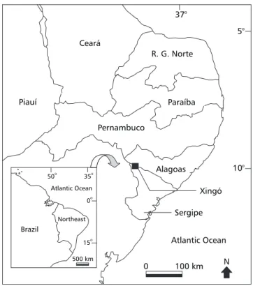
The study site comprises a 2,828.8 km2 piece
(64 km x 44.2 km) of Xingó region (09o36'S,
37o50'W), which is located between the States of
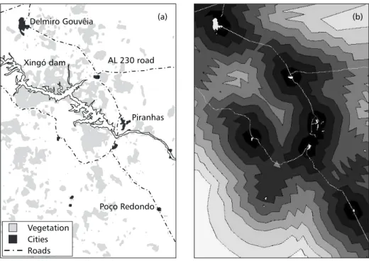
Alagoas and Sergipe, northeast Brazil (Fig. 1). The central point of the study site is the Xingó hydroelectric power station, from which seven small-sized cities (i.e., Poço Redondo, Delmiro Gouvêia, Canindé do São Francisco, Olho d’Água do Casado, Piranhas, Entremontes and Capim Grosso) are spread around and connected by 145 km of paved roads. The study site is over sedimentary basins, mountains, plateau and ravines that surround the São Fransico river in this region (IBGE, 1985). All vegetation types found in Xingó match the physiognomic types of caatinga vegetation, which range from seasonally tropical dry forest (sensu Mooney et al., 1995, Pennington
et al., 2000) to scrub vegetation (Sampaio, 1995). Throughout the caatinga region (736,000 km2), the
caatinga vegetation is constrained by an annual rainfall that ranges from 250 to 900 mm. This gradient of annual rainfall support well developed stands of dry forest with canopy trees 17 m tall and 2,220-28,020 plants ha–1 (stem diameter at soil
level ≥ 3 cm) to 5 m tall scrub types with 619 plants ha–1 (Sampaio, 1996).
At present, Xingó is a regional centre of economic development in the caatinga region due to the establishment of large infrastructure projects associated with land irrigation for agriculture. Delmiro Gouveia, Canindé do São Franciso, Pi-ranhas, Olho d’Água do Casado and Poço Redondo have approximately 2,000 and 40,000 inhabitants. In 1985, before the establishment of the irrigation projects, the rural population had reached 10-20 inhabitants km2 (IBGE, 1985). Therefore it is now
expected that cities become larger, new roads are under construction and more vegetation has been cleared for agricultural purposes. Such large-scale changes will probably cause severe damages on the caatinga biota throughout this region.
Northeast
Pernambuco
Xingó Alagoas
100 km Piauí
R. G. Norte
Paraíba
Atlantic Ocean 5°
10° 37°
Ceará
Sergipe
Atlantic Ocean
Brazil 50o
35o
0o
15o
500 km
0
Maps of remaining vegetation, roads and cities
In order to analyse the relationships between roads, cities and the remaining vegetation in the study site we produced the following digital maps: (1) the map of the remaining vegetation in the study site (Fig. 2a) based on the analysis of satellite imagery (type Landsat 1995, bands 1, 2 and 3) using ERDAS 8.2 software; and (2) the map of the primary and secondary paved roads and cities in the study site (Fig. 2a), based on digitised information from maps (1:1,000,000) produced by SUDENE and from those cities and roads identified by satellite imagery. Based on the first map we calculated the percentage of remaining vegetation in the study site and its distribution in the following classes of fragment size: < 10, 10-100, 100-200, and > 200 hectares. These four fragment size-classes were used in order to obtain a sufficient number of fragments within each size-class and therefore to conduct statistical analysis. We used the digital map of cities and roads to produce a third map using the spatial analyst – calculation procedure of Arc View 3.1 (ESRI, 1998): the map of distance, which mapped all the points distancing between 0 km and 15 km from roads and cities in our study site (Fig. 2b). The distances to
any point represented mean combined values of distances from both cities and roads. We used combined distances from roads and cities because they are spatially related.
Remaining vegetation, habitat fragmentation vs. distance from roads and cities
In order to investigate the relationships between the combined distance (hereafter distance) from roads and cities and: (1) the % of remaining vegetation, and (2) habitat fragmentation, we combined the vegetation map and the map of distance, using Arc View 3.1 (Extension: spatial analyst). Thereby we obtained the percentage of remaining vegetation and of fragments (within size-classes) for each class of distance from roads and cities.
Statistical analysis
We used Spearman correlation coeficients (Sokal & Rohlf, 1995) to analyse the relationships between the classes of distance from roads and cities and: (1) the percentage of remaining vegetation, (2) the percentage of fragments within classes of size; and (3) the percentage of remaining vegetation within classes of fragments size.
(a) (b)
Xingó dam
Piranhas AL 230 road Delmiro Gouvêia
Poço Redondo
Vegetation Cities Roads
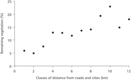
Percentage of remaining vegetation was assigned to distance classes of 1 km width, while fragments were assigned to distance classes of 3 km width based on the geographic location of their centres. We adopted this procedure to guarantee enough data to conduct statistical analysis. Analyses were conducted until the distance from roads as cities reached 15 km, which corresponded to the border of our study site. All the analyses were carried out in Systat 6.0 package (Wilkinson, 1996).
RESULTS
In the study site the remaining vegetation was reduced to 13% from its original cover. We found a positive correlation between distance from roads and cities and the percentage of remaining vegetation (rs = 0.83; p = 0.003; N = 12, Fig. 3). More specifically, in the 1 km distance class, only 5.9% of remaining vegetation was found. In contrast, 18% of remaining vegetation was found in the 12 km distance class. Thus, remaining vegetation was reduced by one third near roads and cities. Percentage of remaining vegetation in the border of our study site (> 12 km distant) was not associated with distance from roads and cities. Among the 1,188 fragments found in the study site, 22.2% (263) were larger than 10 ha and 77.8% (925) were smaller. We did not find any
relationship between the classes of distance and the percentage of fragments < 10 ha. In contrast, the percentage of fragments larger than 200 ha increased from 3.6% within 0 to 3 km class of distance to 23.3% within the12 to 15 km class (Fig. 4; rs = 0.9; p = 0.03; N = 5). In addition, the percentage of remaining vegetation within fragments larger than 200 ha significantly increased from 52.7% to 85.5% considering the same classes of distance (Fig. 5; rs = 1.0; p < 0.0001; N = 5).
DISCUSSION
Cities, roads, habitat loss and fragmentation in caatinga vegetation
Our study site represents a heavily fragmented portion of the caatinga vegetation (1,188 fragments spread over 2,828 km2), which has been reduced
to a small fraction of its original cover. As expected our analyses suggest that the combined distance from roads and cities is a predictor of habitat loss and fragmentation in the caatinga vegetation, although on the border of our study site this relationship was not significant. More specifically, the caatinga vegetation was reduced by one third near roads and cities (i.e., 0 to 1 km distant), and fragments larger than 200 ha were significantly more frequent throughout an increasing distance from roads and cities.
0 5 10 15 20 25
0 2 4 6 8 10 12
Classes of distance from roads and cities (km)
Remaining
vegetation
(%)
0 20 40 60 80 100
1 2 3 4 5
Classes of distance from roads and cities
> 200 100-200 10-100 Fragment size (ha)
N = 28 N = 47 N = 36 N = 49 N = 30
Fragments
(%)
Fig. 4 — Percentage of fragments within classes of size vs. distance from roads and cities in Xingó region, Brazil. Each class of distance represent 3 km and numbers above each vertical bar represent the number of fragments examined in each category.
Fig. 5 — Percentage of remaining vegetation within classes of fragment size vs. distance from roads and cities in Xingó region, Brazil. Each class of distance represent 3 km and numbers above each vertical bar represent the number of frag-ments examined in each category.
0 20 40 60 80 100
1 2 3 4 5
Classes of distance from roads and cities
> 200 100-200 10-100 Fragment size (ha)
N = 28 N = 47 N = 36 N = 49 N = 30
Fragments
(%)
Studies in tropical forests (Laurance, 2000; Laurance et al., 2001), suburban areas (Forman & Deblinger, 2000), wetlands (Findlay & Bourdages, 2000) and protected areas (Clevenger & Waltho, 2000; Rivard et al., 2000) report road-effect zones ranging from 0.1 km to 50 km. Laurance et al. (2001) stated that in the Amazon region both roads and highways averaged about 30% forest loss within the 0 to 10 km zone, but
suggest that the city/road-effect zone (sensu Forman & Deblinger, 2000) may reach from 12 to 15 km width (the border of our study site).
The relationships among roads, cities, habitat loss and fragmentation in our study site are in part due to the regional economic activities, which are based on cattle raising, subsistence agriculture (manioth, maize) and, most importantly, on vegetation harvesting to provide firewood (Lins, 1989; Sampaio, 1995). Just the state of Pernambuco demands 5-6 millions m3 of firewood per year
(Silva, 1993). Such amount comes from illegal harvesting of caatinga vegetation, which provides only 30-80 m3 of firewood per hectare (Silva,
1993). Thereby nearly 70,000 hectares of caatinga vegetation are harvested every year to supply this demand. Firewood exploitation, as well as agricul-ture and cattle raising, probably takes advantage of proximity from roads and cities since it facilitates the access and reduces the costs of goods transportation. An evidence of these relationships is the price of land, directly associated with the proximity from urban areas (Banco do Nordes-te, 1998). Therefore, the caatinga vegetation that surrounds cities and roads is expected to be continuously harvested to provide firewood, crops and livestock. It is reasonable to hypothesise that in our study site, cities create a demand for na-tural resources while roads facilitate their supply by permitting the exploitation of surrounding areas. Specifically in tropical forests, habitat loss and fragmentation associated with roads are first due to timber exploitation followed by forest conversion into agriculture since human activity is facilitated by roads (Laurance et al., 2001). Moreover, several studies report the perversely association among roads, habitat loss and forest fragmentation, which in turn increase fire, hunting and species loss (Fearnside, 1991; Stone, 1998; Findlay & Bourdages, 2000; Laurance, 2000; Laurance et al., 2001). Therefore, the ecological effects of roads and cities on caatinga biota, including the secondary effects resulting from habitat fragmentation, need further and urgent investigation. This statement is in accordance to Vasconcelos Sobrinho (1971) who declared 30 years ago that “dense and well-developed stands of caatinga vegetation only remain in those places in where roads have not yet arrived”.
Implications for conservation
A basic implication of our results regards setting prioritie areas for conservation of caatinga biodiversity. The caatinga’s system of protected natural areas covers 0.87% of the caatinga region (Tabarelli et al., 2000). In addition, current economic activities are projected to eliminate or seriously degrade large portions of this ecosystem (Coimbra-Filho & Câmara, 1997). Large efforts by the national government and research institutions have thus been conducted to identify priority areas for conserving caatinga biodiversity (Silva & Tabarelli, 2000). This is a difficult task since caatinga is poorly known scientifically (see Heyer, 1988; Brasil, 1998). The best approaches for setting priority areas still remain dependent on species distribution databases (Margules & Pressey, 2000), which are incomplete or absent for caatinga species. A logical prediction from our results is that the large between-roads patches contain the last low-altered portions of this ecosystem, once roads and cities are related to habitat loss and fragmentation. A regional plan for setting priority areas for conservation of caatinga should thus consider road and city density as a predictor of previously disturbed areas and as potential sources of habitat degradation regarding future protected areas.
Our results have also implications for the spatial planning of economic activities in the caatinga region. At present, the caatinga region has over than 20,000 km of roads (IBGE, 1985). As road density is higher near the major cities, there are large undeveloped areas, for which development programs are still in debate (Sampaio, 1995). Our results suggest a 12 to 15 km road-city effect in terms of habitat loss and fragmentation of caatinga vegetation. According to (Casteleti et al., 2000) a 10 km road-effect may drastically alter 50% of the caatinga region. Similar situations have been described for other regions in Brazil. In the 80 decade the pavement of road Cuiabá-Porto Velho (BR-364) facilitated the harvesting of 30,000 km2
vegetation exploitation (Vasconcelos Sobrinho, 1971; SUDENE, 1983; Lins, 1989; Sampaio, 1995), land-use planning and programs of regi-onal development should assess the primary and secondary ecological effects of roads and cities before they are set.
In conclusion, our results are evidences that roads and cities play an important role for habitat loss and fragmentation in the caatinga vegetation. The reduction in the percentage of remaining vegetation and in the number of large fragments are probably due to the facilities that cities and roads offers to the exploitation of adjacent natural resources. The results also indicate a city/road-effect zone of 12 to15 km width. Further studies are needed to verify the direct and indirect effects of roads and cities on the caatinga vegetation considering spatial scales shorter and larger than that adopted in this study.
Acknowledgments— We thank the Brazilian Science and Research Council (Conselho Nacional Científico e Tecnológico, CNPq) for funding this study and Programa Xingó/CHESF-CNPq-SUDENE for logistic support.
REFERENCES
BANCO DO NORDESTE, 1998, Manual de avaliação de propriedade rural: terra nua e cobertura vegetal. Relatório Técnico, Recife.
BRASIL, 1998, Primeiro relatório para a Convenção sobre Diversidade Biológica. Ministério do Meio Ambiente, dos Recursos Hídricos e da Amazônia Legal, Brasília. BRASIL, 1999, Desertificação: caracterização e impactos.
Ministério do Meio Ambiente, dos Recursos Hídricos e da Amazônia Legal, Brasília.
CASTELETI, C. H. M., SILVA, J. M. C., TABARELLI, M. & SANTOS, A. M. M., 2000, Quanto resta da Caatinga? Uma estimativa preliminar. In: J. M. C. Silva & M. Tabarelli (coord.), Workshop Avaliação e identificação de ações prioritárias para a conservação, utilização sustentável e repartição de benefícios da biodiversidade do bioma Caatinga, www.biodiversitas.org.br./caatinga. CLEVENGER, A. P. & WALTHO, N., 2000, Factors influencing the effectiveness of wildlife underpasses in Banff National Park, Alberta, Canada. Conser. Biol., 14: 47-56.
COIMBRA-FILHO, A. F. & CÂMARA, I. G., 1997, Os limites originais do bioma Mata Atlântica na região Nordeste do Brasil. Fundação Brasileira de Conservação da Natureza, Rio de Janeiro.
ESRI, 1998, Arcview GIS 3.1. ESRI, United States of America.
FEARNSIDE, P. M., 1991, Rondônia: estradas que levam a devastação. Ciênc. Hoje, Volume especial Amazônia, pp. 116-122.
FINDLAY, R. T. T. & BOURDAGES, J., 2000, Response time of wetland biodiversity to road construction on adjacent lands. Conserv. Biol., 14: 86-91.
FORMAN, R. T. T. & ALEXANDER, L. E., 1998, Roads and their major ecological effects. Ann. Rev. Ecol. Syst., 29: 207-231.
FORMAN, R. T. T. & DEBLINGER, R. D., 2000, The ecological road-effect zone of a Massachusetts (USA) suburban highway. Conser. Biol., 14: 36-46.
FORMAN, R. T. T., 1999, Land mosaics: the ecology of landscape and regions. Cambridge University Press, Cambridge.
GASCON, C., WILLIAMSON, B. & FONSECA, G. A. B., 2000, Receding forest edges and vanishing reserves. Science, 288: 1356-1358.
GOOSEM, M., 2000, Effects of tropical rainforest roads on small mammals: edge changes in community composition.
Wild. Resear., 27: 151-163.
HEYER, R. H., 1988, On frog distribution patterns east of the Andes, pp. 245-273. In: P. E. Vanzolini & R. H. Heyer (eds.), Proceedings of a Workshop on Neotropical Distribution Patterns. Academia Brasileira de Ciências, Rio de Janeiro, Brasil.
IBGE, 1985, Atlas nacional do Brasil. IBGE, Rio de Janeiro. LAURANCE, W. F., 2000, Mega-development trends in the Amazon: Implications for global change. Environ. Monit. Asses., 61: 113-122.
LAURANCE, W. F., COCHRANE, M. A., BERGEN, S., FEARNSIDE, P. M., DELAMÔNICA, P., BARBER, C., D’ANGELO, S. & FERNANDES, T., 2001,The Future of the Brazilian Amazon. Science, 291: 438.
LINS, R. C. (Coord.), 1989, As áreas de exceção do agreste de Pernambuco. Sudene, Recife.
MARGULES, C. R. & PRESSEY, R. L., 2000, Systematic conservation planning. Nature, 405: 243-253. MAYNADIER, P. G. & HUNTER, M. L., 2000, Road effects
on amphibian movements in a forest landscape. Nat. Ar. J.,20: 56-65.
MOONEY, H. A., BULLOCK, S. H. & MEDINA, E., 1995, Introduction, pp. 1-8. In: S. H. Bullock, H. A. Mooney & E. Medina (eds.), Seasonally dry tropical forests.
Cambridge University Press, Cambridge,
PENNINGTON, R. T., PRADO, D. E. & PENDRY, C. A., 2000, Neotropical seasonally dry forests and quaternary vegetation changes. J. Biog., 27: 261-273.
PERES, C. A., 2000, Synergistic effects of subsistence hunting and habitat fragmentation on Amazonian forest vertebrates. Conser. Biol., 14: 240-253.
RIVARD, D. H., POITEVIN, J., PLASSE, D., CARLETON, M. & CURRIE, D. J., 2000, Changing species richness and composition in Canadian national parks. Conser. Biol, 14: 1099-1109.
ROBINSON, J. G., 1996, Hunting wildlife in forest patches: an ephemeral resource, pp. 111-130. In: J. Schellas & R. Greenberg (eds.), Forest patches in tropical landscapes. Island Press, London.
RODRIGUES, S. M. C. B., 1998, Florística e fitossociologia de uma área em processo de desertificação no município de Gilbués-PI. Dissertação de Mestrado, Universidade Federal de Pernambuco, Recife.
RODRIGUES, V., LINHARES, M. C., OLIVEIRA GALVÃO, A. L. & GORGÔNIO, A., 1995, Avaliação do quadro da desertificação no Nordeste do Brasil: diagnóstico e perspectivas, pp. 263-302. In: G. M. Gomes, H. R. Souza & A. R. Magalhães (eds.), Desenvolvimento sustentável no Nordeste. IPEA, Brasília.
SAMPAIO, E. V. S. B., 1995, Overview of the Brazilian Caatinga, pp. 35-63. In: S. H. Bullock, H. A. Mooney & E. Medina (eds.), Seasonal dry tropical forests. Cambridge University Press, London.
SAMPAIO, E. V. S. B., 1996, Fitossociologia, pp. 203-224.
In: E. V. S. B. Sampaio, S. J. Mayo & M. R. V. Barbosa (eds.), Pesquisa botânica nordestina: progressos e perspectivas. Sociedade Botânica do Brasil, Seção Regional de Pernambuco, Recife.
SILVA, J. M. C. & TABARELLI, M. (Coord.), 2000,
Workshop Avaliação e identificação de ações prioritárias para a conservação, utilização sustentável e repartição de benefícios da biodiversidade do bioma Caatinga. www.biodiversitas.org.br./caatinga.
SILVA, P. S., 1993, Consumo de energéticos florestais do setor industrial/comercial no Estado de Pernambuco. PNUD/FAO/IBAMA, Recife.
SOKAL, R. R. & ROHLF, F. J., 1995, Biometry. W. H. Freeman and Company, New York.
SPELLERBERG, I. F., 1998, Ecological effects of roads and traffic: a literature review. Global Ecol. Biog. Lett., 7: 317-333.
STILES, J. H. & JONES, R. H., 1998, Distribution of the red imported fire ant, Solenopsis invicta, in road and powerline habitats. Lands. Ecol., 13: 335-346. STONE, S. W., 1998, Using a geographic information system
for applied policy: the case of logging in the Eastern Amazon. Ecol. Econ., 27: 43-61.
SUDENE, 1983, Processos de desertificação no Nordeste. Relatório Técnico, SUDENE, Recife.
TABARELLI, M., SILVA, J. M. C., SANTOS, A. M. M. & VICENTE, A., 2000, Análise de representatividade das unidades de conservação de uso direto e indireto na Caatinga: análise preliminar. In: J. M. C. Silva & M. Tabarelli (Coord.), Workshop Avaliação e identificação de ações prioritárias para a conservação, utilização sustentável e repartição de benefícios da biodiversidade do bioma Caatinga. www.biodiversitas.org.br./caatinga. TINKER, D. B., RESOR, C. A. C., BEAUVAIS, G. P., KIPMUELLER, K. F., FERNANDES, C. I. & BAKER, W. L., 1998, Watershed analysis of forest fragmentation by clearcuts and roads in a Wyoming forest. Lands. Ecol., 13: 149-165.
VASCONCELOS SOBRINHO, J., 1971, As regiões naturais do Nordeste, o meio e a civilização. Conselho de Desenvolvimento de Pernambuco, Recife.
WILKINSON, L., 1996, SYSTAT, version 6.0. SPSS, Chicago, USA.