Community Page
The Common Oceanographer: Crowdsourcing the
Collection of Oceanographic Data
Federico M. Lauro1,2*, Svend Jacob Senstius3, Jay Cullen4, Russell Neches5, Rachelle M. Jensen1, Mark V. Brown1, Aaron E. Darling6, Michael Givskov2,7, Diane McDougald2,8, Ron Hoeke9, Martin Ostrowski10, Gayle K. Philip11, Ian T. Paulsen10, Joseph J. Grzymski12*
1School of Biotechnology and Biomolecular Sciences, The University of New South Wales, Sydney, New South Wales, Australia,2Singapore Centre on Environmental Life Sciences Engineering (SCELSE), Nanyang Technological University, Singapore,3Department of Transport, Technical University of Denmark, Copenhagen, Denmark, 4School of Earth and Ocean Sciences, University of Victoria, Victoria, British Columbia, Canada,5Genome Center, University of California, Davis, California, United States of America,6The ithree institute, University of Technology Sydney, Ultimo, New South Wales, Australia,7Costerton Biofilm Center, Department of International Health, Immunology, and Microbiology, Faculty of Health and Medical Sciences, University of Copenhagen, Copenhagen, Denmark,8Centre for Marine Bio-Innovation, University of New South Wales, Sydney, New South Wales, Australia,9Centre for Australian Climate and Weather Research, CSIRO, Aspendale, Victoria, Australia,10Department of Chemistry and Biomolecular Sciences, Macquarie University, Sydney, New South Wales, Australia,11VLSCI Life Sciences Computation Centre, University of Melbourne, Melbourne, Victoria, Australia,12Division of Earth and Ecosystem Sciences, Desert Research Institute, Reno, Nevada, United States of America
We live on a vast, underexplored planet that is largely ocean. Despite modern technology, Global Positioning System (GPS) navigation, and advanced engineer-ing of ocean vessels, the ocean is unfor-giving, especially in rough weather. Coast-al ocean navigation, with risks of running aground and inconsistent weather and sea patterns, can also be challenging and hazardous. In 2012, more than 100 international incidents of ships sinking, foundering, grounding, or being lost at sea were reported (http://en.wikipedia.org/ wiki/List_of_shipwrecks_in_2012). Even a modern jetliner can disappear in the ocean with little or no trace [1], and the current costs and uncertainty associated with search and rescue make the prospects of finding an object in the middle of the ocean daunting [2].
Notwithstanding satellite constellations, autonomous vehicles, and more than 300 research vessels worldwide (www. wikipedia.org/wiki/List_of_research_ vessels_by_country), we lack fundamental data relating to our oceans. These missing data hamper our ability to make basic predictions about ocean weather, narrow the trajectories of floating objects, or estimate the impact of ocean acidification and other physical, biological, and chem-ical characteristics of the world’s oceans. To cope with this problem, scientists make probabilistic inferences by synthesizing models with incomplete data. Probabilistic modeling works well for certain questions of interest to the scientific community, but it is difficult to extract unambiguous policy recommendations from this approach.
The models can answer important questions about trends and tendencies among large numbers of events but often cannot offer much insight into specific events. For example, probabilis-tic models can tell us with some precision the extent to which storm activity will be intensified by global climate change but cannot yet attribute the severity of a particular storm to climate change. Probabilistic modeling can provide important insights into the global traffic patterns of floating debris but is not of much help to search-and-rescue personnel struggling to learn the likely trajectory of a particular piece of debris left by a wreck.
Oceanographic data are incomplete because it is financially and logistically impractical to sample everywhere. Scien-tists typically sample over time, floating with the currents and observing their temporal evolution (the Langrangian ap-proach), or they sample across space to cover a gradient of conditions—such as temperature or nutrients (the Eulerian approach). These observational paradigms have various strengths and weaknesses, but
their fundamental weakness is cost. A modern ocean research vessel typically costs more than US$30,000 per day to operate—excluding the full cost of scien-tists, engineers, and the cost of the research itself. Even an aggressive expan-sion of oceanographic research budgets would not do much to improve the precision of our probabilistic models, let alone to quickly and more accurately locate missing objects in the huge, moving, three-dimensional seascape. Emerging au-tonomous technologies such as underwater gliders and in situ biological samplers (e.g., environmental sample processors) help fill gaps but are cost prohibitive to scale up. Similarly, drifters (e.g., the highly success-ful Argo floats program) have proven very useful for better defining currents, but unless retrieved after their operational lifetime, they become floating trash, add-ing to a growadd-ing problem.
Long-term sampling efforts such as the continuous plankton recorder in the North Sea and North Atlantic [3] provide valuable data on decadal trends and leveraged English Channel ferries to accomplish much of the sampling.
The Community Page is a forum for organizations and societies to highlight their efforts to enhance the dissemination and value of scientific knowledge.
Citation:Lauro FM, Senstius SJ, Cullen J, Neches R, Jensen RM, et al. (2014) The Common Oceanographer: Crowdsourcing the Collection of Oceanographic Data. PLoS Biol 12(9): e1001947. doi:10.1371/journal.pbio. 1001947
PublishedSeptember 9, 2014
Copyright: ß2014 Lauro et al. This is an open-access article distributed under the terms of the Creative Commons Attribution License, which permits unrestricted use, distribution, and reproduction in any medium, provided the original author and source are credited.
Funding:The authors acknowledge financial support from the School of BABS (University of New South Wales), the ithree Institute (University of Technology Sydney), the Costerton Biofilm Center (University of Copenhagen), the Singapore Centre on Environmental Life Sciences Engineering (Nanyang Technological University), the Desert Research Institute, and the University of Victoria. JTC was supported by the Natural
Competing Interests:The authors have declared that no competing interests exist. * Email: [email protected] (FML); [email protected] (JJG)
Modernizing and expanding this approach is a goal of citizen science initiatives. How do we leverage cost-effective technologies and economies of scale given shrinking federal research budgets?
Citizen Scientists Can Make an Important Contribution
There are many actions that can be taken to improve the precision of our models, but the most obvious is to increase spatial and temporal density of our observations. However, the cost of ocean-ographic research vessels makes this im-practical. The inevitable conclusion is that observations must be obtained by some other means. We propose a worldwide effort to empower sailors and retrofit sailboats to increase coverage of sample and data collection along common routes around the world.
Modern oceanographic research vessels are large and expensive because they are designed to be general-purpose scientific platforms. They are sophisticated labora-tory facilities that serve the diverse needs of the scientific community for many decades. These vessels are costly because their scientific capabilities are both wide ranging and deep penetrating. The ocean is too vast for any vessel to see very much of it, no matter its capabilities. Maximizing the number of observers, rather than the capabilities of observers, requires a very different approach to the choice of vessel, personnel, instrumenta-tion, and protocol.
Can meaningful data be collected with the kind of narrowly focused, low-cost instrumentation that is easily mass pro-duced and deployable? If so, what vessels will carry it, and what personnel will operate it? Many aspects of modern oceanography, such as locating an un-derwater object, require sophisticated equipment and trained experts. However, some of the most important types of observations require only that one be in the right place at the right time with simple instrumentation or sampling equipment. Important data can be gath-ered by anyone who can follow basic instructions. This is the premise of ‘‘citizen science’’ (Box 1). Rather than dispatching scientists into the environ-ment to collect data, scientists may instead train people who already interact with the environment to apply the scientific method to phenomena they already observe. With or without an invitation, citizen scientists exist. There is an urgent need to make a place for them in the scientific community.
Historical Perspective
A mistaken and modern perception is that science is an elitist profession, rele-gated to well-funded laboratories with complex instrumentation run by professors with years of advanced education. Histor-ically, this was not always the case. In fact, people who conducted scientific research as a hobby achieved some of the greatest discoveries in history. For example, Leo-nardo da Vinci painted portraits for income while doing science in his spare time. Gregor Mendel, an Augustinian friar, discovered the basis of genetic inheritance while working in the garden of his monastery, and Michael Faraday laid the foundation of electromagnetic induction while working as an apprentice bookbinder and bookseller, educating himself. Arguably the most famous ‘‘citi-zen oceanographer’’ was Charles Darwin, who had no formal training in biology but became one of the most celebrated and influential evolutionary biologists in histo-ry. He detailed the geology and formation of coral reefs during the 1832–1836 voyage of HMSBeagle. Similarly, Benja-min Franklin, also a ‘‘citizen oceanogra-pher,’’ published a number of ideas on Atlantic Ocean currents, catamaran hulls, and sea anchors and designed a spill-proof bowl for eating soup on board a ship in stormy seas.
Despite this long tradition, the involve-ment of amateurs in oceanographic dis-coveries declined in the 20th century, perhaps contributing to the growing mis-understanding of scientific jargon by the public when it pertains to ocean and atmospheric circulation. This has led to the current political shape-shifting of scientific results (e.g., the climate change debate). In the last few years, mostly due to technological breakthroughs, we have witnessed revitalization in the participa-tion of civilians in data collecparticipa-tion: Alan Irwin described the social aspects of this revolution in 1995 [4] and coined the term ‘‘citizen science.’’
The United States National Weather Service Cooperative Observer Program (NWS-COOP) is a great example of a successful citizen science initiative. The program was established in 1890 and utilizes a network of more than 11,000 volunteers to provide observational data of basic weather parameters. Similarly, the USA National Phenology Network is a group of scientists and trained citizen scientists who collect observations about plant and animal phenology. This multi-decadal program helps scientists, for example, better understand climate change [5].
With thoughtfully designed and well-tested equipment and protocols, citizen scientists can gather vast quantities of oceanic data or samples for analysis (Box 2). Three technologies have provided the technical means for networked data col-lection: the miniaturization of sample collection devices, the progressive reduc-tion in the cost of sequencing, and the computing and easy data sharing of cloud-based analysis [6].
Oceanography using large ships has a significant carbon and economic footprint, but spatially extensive and temporally intensive data are needed. More specifi-cally, in marine microbiology, data collec-tion has become the bottleneck, since it is currently impossible to quantify the total-ity of oceanic microbial communities and their environmental drivers by remote sensing or individual research cruises. Expansive budgetary cuts to environmen-tal sciences around the globe and the concurrent need to renew an aging fleet of ocean vessels [7] underscore the urgency.
Long-Term Oceanographic Research with Citizen Scientists
How do we increase temporal and spatial coverage of the ocean? A single oceanographic research vessel can cover a small fraction of the ocean. During a continuous year at sea, without stopping for fuel or crew change, a single research Box 1. Citizen Science Primer
Citizen science is a manner of collecting data and observations in which collaborators who may lack credentials and formal institutional affiliation can contribute to the work. Because one does not vet collaborators on the basis of affiliation and credentials, a citizen science research project must be specific and self-contained in terms of what is asked of collaborators.
vessel could cover ,3% of ocean-area sampling at a distance of 1 degree, traveling at 10 knots between stations and only stopping at each station for two hours. Despite this being an enormous area, representing 9.7 million km2 (area calculation from the Goode Homolosine projection), it conservatively would cost at least US$15 million for the boat, the crew, the science, and the scientists. Twenty vessels would be required to operate at this intensity to cover the midlatitude region, putting into perspective the costs of conducting oceanography on a global ocean-basin scale. The carbon footprint of this effort would be enormous. The costs would exceed US$300 million dol-lars, and the results would still exclude the entire high-latitude oceans.
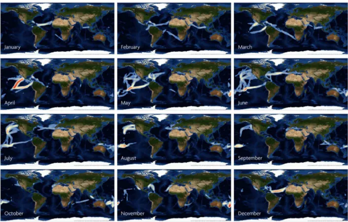
Citizen oceanography, specifically sci-ence conducted aboard sailing yachts, would overcome many of these hurdles and empower civilian scientists with the pride of data contribution to science, providing an incredible opportunity for outreach as well as improving science education and increasing public awareness. Participation of a small fraction of the thousands of vessels that continu-ously cruise remote parts of the oceans (Figure 1) could comprise a global ocean-ographic monitoring network that would boost the predictive power of scientific models. This would be a natural group of citizen scientists inherently motivated by their love of sailing and empirical knowl-edge of the beauty, power, and vastness of the world’s oceans. Given the complexities and importance of the coastal ocean, an obvious question is, why not include
coastal recreational sailors in this call to action? The coastal waters present prob-lems related to permitting, and deregulat-ed sampling would infringe on the exclu-sive economic rights of nations’ territorial waters. However, other initiatives such as Ocean Sampling Day [8] can be extended to cover multiple days throughout the year. In partnership with coastal schools and universities, this is a huge pool of citizen scientists and citizen data collec-tors.
As a specific example, we know rela-tively little about the inventory of microorganisms and their variability in the oceans. Biological sampling by citizen scientists could be accomplished using mass-produced Niskin bottles, preloaded with fixatives, for flow cytometry and nutrient analysis. A basic conductivity-temperature-depth (CTD) device could be manufactured using standard mass-market consumer electronic practices for measur-ing physical properties. Inexpensive digital weather stations already exist for record-ing conditions and are commonplace on small, private vessels. A wide-angle camera and an inexpensive embedded computer could be used to automatically identify and catalogue debris with image-process-ing software.
Repetitive sampling through time is important to grasp the complexities of dynamic systems (cf. [9–11]). The long-term ecological research (LTER) model for understanding ecosystem function and change across relevant temporal scales has produced numerous significant observa-tions [12,13]. Two important long-term research observatories in the Atlantic
(Bermuda Atlantic Time-series Study [BATS]) and Pacific (Hawaiian Ocean Time-series [HOT]) have revolutionized our understanding of biology and chemis-try in the ocean [14]. Yet, these are only two stations in the middle of vast oceans.
There is repetitive, seasonal yacht traffic along common sailing routes around the globe (Figure 1). At least 5,000 sailing yachts travel the oceans every year using several popular routes. For example, ,400 yachts per year embark on the Pacific Coconut Milk Run, which is approximately a 6,000 nautical mile jour-ney from the western US or Panama Canal to New Caledonia in the Southwest Pacific. This popular route is marked by relatively mild weather and easterly trade winds. The Atlantic Ocean has similar seasonal and favorable sailing routes. The trade wind route (westward from Canaries to the Caribbean) is mostly sailed in winter, while the Bermuda-Azores (east-ward) is popular in the summer (Figure 1). Both attract hundreds of sailors every year, as they are a part of every sailor’s ‘‘wish list,’’ having been used since the Age of Discovery in the early 15th century. If a metadata and sample collection system were in place, sailors on popular routes such as these could be a part of a larger, LTER-like sampling collective. Ocean-going sailors have an extensive network already in place for communication, passage notes, weather, etc. (e.g., http:// www.cruiserswiki.org/; http://pangolin. co.nz/); expanding this infrastructure is trivial compared to current research vessel costs. These routes can be used to monitor the ocean repetitively for interannual and long-term changes, much like the NWS-COOP or National Phenology Network programs.
Any data gaps in areas with lower density of recreational sailors (e.g., high latitudes) could be filled by engaging commercial shipping companies, which have vessels that operate in those waters [15].
Lessons Learned from the Indigo V Indian Ocean Expedition
Many projects have struggled with the unique technical, logistical, organizational, and ethical issues that arise for each discipline when researchers endeavor to involve citizen scientists. In 2013, the Indigo V Indian Ocean Expedition was conceived as a pilot project and learning laboratory for citizen science approaches to oceanography. The team sailed S/Y Indigo V—a 61-foot Nautor Swan sailing Box 2. Citizen Scientists Could Collect Several Types of
Important Oceanographic Data
N
Biological samplesevaluate the effect of human activities depends on quantifying the microbial. Our ability to monitor the status of the world’s oceans andcommunities in all ocean basins and understanding their community structure and function in response to natural and anthropogenic perturbations. Marine microbes are the foundation of the planet’s trophic networks and play a critical role in planetary biogeochemical processes. They are the sentinels of the sea and respond rapidly to perturbations (e.g., Deepwater Horizon [22]).
N
Basic physical parameters. Temperature and conductivity, coupled with depth, reveal the hidden structure of ocean currents. Much of these structures cannot be directly observed with satellite and other remote-sensing technologies.N
Surface weather conditionssophisticated Doppler radar systems used in terrestrial weather forecasting.. Most of the world’s oceans are not covered by theWeather satellites can reveal a great deal by observing clouds from above but have limited ability to directly observe conditions underneath them. Simple rainfall observations and observations of sea surface and wave heights would be helpful for modeling.
yacht—across the Indian Ocean from Cape Town, South Africa, to Phuket, Thailand. The three legs of the journey covered approximately 5,800 nautical miles. During this expedition, instruments and methods adaptable to citizen scientist deployment were tested aboard small vessels not designed or equipped for research. In all but the heaviest seas, the crew was able to inventory the surface water population of bacterioplankton using a simple pump and filtration appara-tus and make basic measurements of ocean physics and chemistry. DNA and RNA were successfully recovered from samples preserved using a nontoxic salt solution (RNAlater, Qiagen, Valencia, California).
The prototype ocean sampling microbial observatory (OSMO) is currently being ruggedized and automated for citizen-science-based collections of bacterioplank-ton samples. This device is being developed as a collaboration between the Indigo V team members in their laboratories in the US, Singapore, and Australia and will auto-nomously sample microbial populations
onto filters and preserve them. The sail-or/scientist would be responsible for meta-data collection, uploading that meta-data to a central database, and shipping the samples back to the lab for processing. The total cost of design, prototyping, field-testing, and commercializing this device is less than US$200,000. Ultimately, the total cost of microbial sample collection, processing, and sequencing using this approach and device could be reduced to,US$1,500 per sample or less. It will be cost-effective to inventory the microbial community of an ocean basin. The citizen science can be extended to the data analysis phase by online annotation tutorials.
Many aspects of science aboard a sailing yacht are similar to science aboard a research vessel. There is an intense focus on collecting samples; by simplifying the sample collection methodology, this task can be taught to sailors. Similarly, obser-vations aboard a sailing yacht are a part of daily life—situational awareness is essential for the safety of the crew and the boat. Wind speed, sea state, sea height,
and currents are observational data that can be collected by sailors to im-prove global ocean models (or verify predictions).
By employing sail power, the Indigo V project demonstrated that an entire four-month expedition, sampling a wide range of waters with a variety of instruments, costs the equivalent of a day or two of ship time aboard an oceanographic research vessel. Relative to a typical research vessel, the use of sail power reduced carbon emissions resulting from vessel operations by approximately 1000-fold. For compari-son, a recent global oceanographic project (http://www.expedicionmalaspina.es/) col-lected samples at 180 stations with a budget of US$23 million [16,17], and another (http://oceans.taraexpeditions.org/) sam-pled 375 stations with a budget of over US$12 million [18–21]. The Indigo V Indian Ocean Expedition collected samples at 50 stations for less than US$75,000. Imagine what the thousands of yachts that are already out on the water could do.
Figure 1. Month-by-month maps of sailing yacht transits around the world.Data are collected from the YOTREPS network (http://www. pangolin.co.nz/) of cruising yachts worldwide and plotted with Esri ArcGIS 10.2.1. Density of yacht traffic is highest in red. Note the seasonal patterns of transits in the various oceans: high density of traffic during the ‘‘Coconut Milk Run’’ in the Pacific beginning in April, eastward Atlantic ocean traffic during the boreal summer and westward during the boreal winter, and passages to Alaska in the heart of the boreal summer. Used with permission. Esri, DigitalGlobe, 2014.
Acknowledgments
We thank the many volunteers who sailed S/Y
Indigo V: Trent Goldsack, Joshua (Jeff Gold-blum) Goldstein, Ruth McCance, Raymond
Pennotti, Lilia Pitacco, Joseph Podvorec, Alain Talbot, and Jasna Zarkovic.
We also thank Xie Chao, Daniela Drautz, Thomas Jeffries, Helder Marcal, Sophie Maz-ard, Brett Neilan, Iva Neveux, and Rohan
Williams for technical assistance and insightful discussions as well as guidance and encourage-ment. We thank Mike Harris for generously sharing the YOTREPS data.
References
1. McNutt M (2014) The hunt for MH370. Science 344: 947.
2. Allen TW (2010) U.S. coast guard faces change, challenges head-on. Sea Technol 51: 13–14. 3. Warner AJ, Hays GC (1994) Sampling by the
continuous plankton recorder survey. Progr in Oceanog 34: 237–256.
4. Irwin A (1995) Citizen Science: A Study of People, Expertise and Sustainable Development. Oxon, United Kingdom: Routledge.
5. Ault TR, Henebry GM, de Beurs KM, Schwartz MD, Betancourt JL, et al. (2013) The False Spring of 2012, Earliest in North American Record. EOS 94: 181–182.
6. Haklay M (2012) Citizen Science and Volun-teered Geographic Information – overview and typology of participation. In: Sui DZ, Elwood S, Goodchild MF, editors. Crowdsourcing Geo-graphic Knowledge: Volunteered GeoGeo-graphic Information (VGI) in Theory and Practice. Berlin: Springer. pp. 105–122.
7. Cressey D (10 June 2013) US science fleet’s future is far from ship-shape. Available: http://www. nature.com/news/us-science-fleet-s-future-is-far-from-ship-shape-1.13164. Accessed 5 August 2014.
8. Davies N, Field D, Amaral-Zettler L, Clark MS, Deck J, et al (2014) The founding charter of the Genomic Observatories Network. GigaScience 3: 2. 9. Hobbs RJ, Yates S, Mooney HA (2007) Long-term data reveal complex dynamics in grassland
in relation to climate and disturbance. Ecol Monogr 77: 545–568.
10. Walther GR, Post E, Convey P, Menzel A, Parmesan C, et al. (2002) Ecological responses to recent climate change. Nature 416: 389–395. 11. Wootton JT, Pfister CA, Forester JD (2008)
Dynamic patterns and ecological impacts of declining ocean pH in a high-resolution multi-year dataset. Proc Natl Acad Sci U S A 105: 18848–18853.
12. Ainsworth EA, Long SP (2005) What have we learned from 15 years of free-air CO2enrichment (FACE)? A meta-analytic review of the responses of photosynthesis, canopy properties and plant production to rising CO2. New Phytol 165: 351– 372.
13. Montes-Hugo M, Doney SG, Ducklow HW, Fraser W, Martinson D, et al. (2009) Recent changes in phytoplankton communities associated with rapid regional climate change along the western Antarctic Peninsula. Science 323: 1470– 1473.
14. Siegel DA, Karl DM, Michaels AF (2001) Interpretations of biogeochemical processes from the US JGOFS Bermuda and Hawaii time-series sites. Deep-Sea Res II 48: 1403–1404. 15. Kaluza P, Ko¨lzsch A, Gastner MT, Blasius B
(2010) The complex network of global cargo ship movements. J R Soc Interface. doi:10.1098/ rsif.2009.0495
16. Malaspina (2010) About Malaspina: Project structure. Available: http://scientific.expedi cionmalaspina.es/#!/n/about-malaspina/264/ project-structure. Accessed 6 August 2014. 17. UPV, EHU (2014) Projects - Marine Microbes
Research Group. Available: http://www.ehu.es/ en/web/marinemicrobes/proiektuak. Accessed 6 August 2014.
18. EMBL (2014) Tara Oceans science - Facts & Figures. Available: http://www.embl.de/tara-oceans/start/facts_figures/index.html. Accessed 6 August 2014.
19. Tara Expeditions (2014) Rapport d’activite´ 2009 du fonds tara. Available: http://oceans. taraexpeditions.org/wp-content/uploads/2014/ 06/rapport-activite-2009.pdf. Accessed 6 August 2014.
20. Tara Expeditions (2014) Rapport d’activite´ 2010 de Tara Expe´ditions. Available: http://oceans. taraexpeditions.org/wp-content/uploads/2014/ 06/rapport_2010_tara_expeditions.pdf. Accessed 6 August 2014.
21. Tara Expeditions (2014) Rapport d’activite´ 2011. Available: http://oceans.taraexpeditions.org/wp- content/uploads/2014/06/rapport-activite-2011def.pdf. Accessed 6 August 2014. 22. Hazen TC, Dubinsky EA, DeSantis TZ,