.ufc.br
1/15
ISSN: 1984-2201
Copyright © 2002, Universidade Federal do Ceará
URBAN-REGIONAL DYNAMICS IN INTERNAL
BORDER TERRITORIES
ABSTRACT
This work aims to understand the Upper West Potiguar as an internal border region, located in Rio Grande do Norte (RN) state, between the states of Paraíba (PB) and Ceará (CE), scaled by the urban-regional dynamics led by the municipality of Pau dos Ferros / RN, as a polarizing center. To this end, a theoretical course was set involving the concepts of territory, borders and urban-regional dynamics, and also a metho-dological course, which articulated these concepts to the analysis of residential data regarding the origin of higher education students and the commuting movements of people for study and work in Pau dos Ferros. It was found that the Upper West Potiguar is characterized as an internal region-border because it is located on the limits of states whose development was marked by this condition, distant from the ecumenes, and
because it contains specific urban-regional dynamics, in the tempo of a polarizing center that converges
hodiernal social and economic dynamics to itself.
Keywords: Upper West Potiguar; Region-border; Internal border; Urban-regional Dynamics; Pau dos Ferros-RN.
RESUMO / RESUMEN
DINÂMICAS URBANO-REGIONAIS EM TERRITÓRIOS DE FRONTEIRA INTERNA
Este trabalho objetiva compreender o Alto Oeste Potiguar como uma região de fronteira interna, localizada no Rio Grande do Norte (RN), entre os estados da Paraíba (PB) e do Ceará (CE), dimensionada pelas dinâmicas urbano-regionais lideradas pelo município de Pau dos Ferros/RN, como centro polarizador. Para tanto, faz-se um percurso teórico que envolve os conceitos de território, fronteiras e dinâmicas urbano--regionais, e um percurso metodológico, em que articula esses conceitos à análise de dados de origem residencial de alunos de ensino superior e de movimentos pendulares de pessoas para estudo e trabalho em Pau dos Ferros. Constatou-se que o Alto Oeste Potiguar se caracteriza como uma região-fronteira interna por se situar nos limites de estados cujo desenvolvimento foi marcado por essa condição, distante dos
ecúmenos, e por conter específica dinâmica urbano-regional, ao compasso de um centro polarizador que
converge para si hodiernas dinâmicas sociais e econômicas.
Palavras-chave: Alto Oeste Potiguar; Região-fronteira; Fronteira interna; Dinâmicas Urbano-regionais; Pau dos Ferros-RN.
DINÁMICAS URBANO REGIONALES EN TERRITORIOS DE FRONTERA INTERNA
Este trabajo objetiva comprender el Alto Oeste Potiguar como una región fronteriza interna, ubicada en el Río Grande del Norte (RN), entre los estados de Paraíba (PB) y Ceará (CE), dimensionada por las dinámicas urbano-regionales dirigidas por el municipio de Pau dos Ferros/RN como centro polarizador. Para tanto, se hace una trayectoria teórica que envuelve los conceptos de territorio, fronteras y dinámicas urbano-regionales, y un trayecto metodológico que articula esos conceptos con el análisis de datos de origen residencial de alumnos de la enseñanza superior e de movimientos pendulares de personas para estudio y trabajo en Pau dos Ferros. Se comprobó que el Alto Oeste Potiguar se caracteriza como una re-gión fronteriza interna que está ubicada en los límites de los estados cuyo desarrollo fue marcado por esta
condición, distante de las zonas habitables o aptas, y por contener una dinámica específica urbano-regional,
al compás de un centro de polarización que converge para la dinámica social y económica en la actualidad.
Palabras clave: Alto Oeste Potiguar; Región fronteriza; Frontera interna; Dinámicas Urbano-Regionales. (*)CORRESPONDING AUTHOR
Address: UERN, Campus de Pau dos Ferros, BR 405, KM 150, S/N, CEP: 59900000, Pau dos Ferros (RN), Brasil. Tel: (+55 84) 33512560 E-mail: [email protected]
Article history:
Received 10 November
, 2017
Accepted 10 January
, 2018
Publisher 15 February
, 2018/
(a) Phd in Geography. Professor State University of Rio Grande do Norte (UERN). ORCID ID: https://orcid.org/0000-0003-2232-9539. CURRICULUM LATTES: http://lattes.cnpq.br/3254661019394995
(b) Phd in Geography. Professor State University of Rio Grande do Norte (UERN). ORCID ID: https://orcid.org/0000-0002-1028-9878. CUR-RICULUM LATTES: http://lattes.cnpq.br/4433766427566452
(c) Phd in Linguistics and Portuguese Language. Professor State University of Rio Grande do Norte (UERN). ORCID ID: https://orcid.org/0000-0001-7637-0751. CURRICULUM LATTES: http://lattes.cnpq.br/3773731288635522
ALVES, Larissa da Silva Ferreira; a * DANTAS, Joseney Rodrigues de Queiroz; b
www
.mercator
INTRODUCTION
The focus of this study is the Upper West Potiguar, located in Rio Grande do Norte (RN), and which is bordered by municipalities of the states of Paraíba (PB) and Ceará (CE), in the interior of the semi-arid Northeast, far from the state capitals and other population centers. The Upper West Potiguar is a region historically marked by low human development indexes, by the great droughts
that lead to prolonged periods without rain, by insufficient public policies favoring social and eco
-nomic dynamics, and by the lack of action on the part of research institutions, such as universities. Considering these issues and in view of the need for research and contributions to this theme, the purpose of this work is to understand the region of the Upper West Potiguar as an internal border region (or internal border-region), located between the states of RN, PB and CE, and shaped by the urban-regional dynamics led by the municipality of Pau dos Ferros / RN, as a polarizing center.
The interest in studying this region is also justified by the small amount of research linked to urban-regional planning in the semi-arid. As an academic field that traditionally studies space for its regional-metropolitan scope, it is currently including the dynamics of interiorized areas with
singularities in relation to the characteristics of the reproduction of space of ecumenes1 as an area
of interest for study. Historically, the semi-arid region has been regarded as a scenario for territorial planning in the face of its specific climatic conditions characteristic of an insulated dry area in the humid South American continent, which has developed a complex internalized network of socially and culturally evolved urban centers by a wide dependence of its regional context (AB’SABER, 2003).
The Brazilian semi-arid region is currently undergoing territorial reconfiguration, largely mo
-tivated by transversal public policies that have guaranteed more investments in interiorized areas of the country, establishing and attracting populations and also leading to a decentralization of services. These reconfigurations that the semi-arid is passing through are intensified in the Upper West Potiguar region, which has singularities and demands academic and scientific studies that interpret and explain it in its urban-regional configuration.
Recently, in the twenty-first century, there has been a strengthening of higher education in the region leading to the emergence of studies in the field of urban-regional planning. This is the case, for example, of the creation of the Postgraduate Program in Planning and Territorial Dynamics in the Semi-Arid (PLANDITES) of the State University of Rio Grande do Norte (UERN), Pau dos
Ferros Campus, which aims to discuss this territorial and thematic field (the semi-arid), articula
-ting nuances permitted by the study of the territory, such as boundaries, cultures, urban-regional dynamics, internalized networks, identity, planning and public policies.
Linked to the PLANDITES, this work aims to contribute to the understanding of a specific urban-regional dynamic experienced in the internal border region of the Upper West Potiguar. This region-border is articulated by the municipality of Pau dos Ferros, insofar as its municipal core
functions as a medium-sized city in the region, although it does not have a significant population.2
It also seeks to reflect on internal borders (located within the boundaries of federative states of the
same nation) and how border areas reinvent themselves, creating specific forms of social reproduc
-tion and development marked by this spatial condi-tion.
To reflect on the region under study, two questions were taken into account in the development of the present article: first, what are the guiding elements for the formation of an internal border region in the extreme west of the state of Rio Grande do Norte, with regard to the various elements that fragment and disarticulate it with the social-spatial context of its state? Secondly, what are the urban-regional dynamics that allow the measurement and characterization of a regional border unit?
(1) Inhabited parts of the Earth; concentration of populations.
Mercator, Fortaleza, v. 17, e17003, 2018
.ufc.br
Urban-Regional Dynamics in Internal Border Territories
The theoretical and methodological reflections for this research come from approaches that can be articulated to analyze the problematics in question. The conceptualizations on territory are based on the understanding of Castro (2009), who visualizes territory as a space circumscribed by the actions of political institutions, but also as the space of conflicts. Various authors are used to comprehend the border, such as Moraes (2008), who understands borders as ideological construc-tions of State formation; Becker (2004), who sees them as spaces for projecting the future; and Haesbaert (2011) and Almeida (2005), who conceive them as the space of the other, of otherness. To understand the internal border-region, in this case the Upper West Potiguar, the studies of Geiger (1993) were adopted, which understand borders from the perspective of classical border regions with a low density of activities and populations, located on state boundaries and whose development is marked by this condition, but also as geographic areas that are now new phases of development. To conceptualize the urban-regional dynamics, we adopted the concepts of Egler (2011), for whom these dynamics are linked to interpretations of commuting flows and mutual dependence between territories.
The methodological procedures adopted in this article articulate the concepts of territory, boundaries and urban-regional dynamics to the analysis of the residential data of higher education
students and the commuting movements3 of people to study and work to Pau dos Ferros, the
po-larizing center. The residential data of students studying at UERN, Pau dos Ferros Campus, were obtained directly from the Campus (UERN, 2016). The decision to use the UERN data is due to the fact that this institution is the oldest in Pau dos Ferros and region, because it had the most students enrolled and it also had the largest number of undergraduate and postgraduate courses. Data on commuting in the region was also used, based on the commuting mobility microdata of the IBGE census (2010), for which the Commuting Efficiency Index (IEPend) and the matrix of mobility flows for study and work in the Upper West Potiguar region-border were prioritized.
This paper is organized into five sections: the current section, the Introduction, reflects on the object of study, problems, objectives, justifications, theoretical and methodological references and the structuring of the article; the section Territory and border seeks to draw the theoretical-conceptual bases of territory and border; the section The region of the Upper West Potiguar: urban-regional dynamics in an internal border zone, gives a brief history of the Upper West Potiguar region, in order to situate the reader in the historical context for the conceptual and empirical understanding of the current urban-regional dynamics in the region; the section entitled The internal region-border of the Upper West Potiguar: Pau dos Ferros in the urban-regional dynamics, which suggests an understanding of certain social-spatial indicators that justify and characterize the unity of the Upper West Potiguar region-border, polarized by the convergence of education and work services that Pau dos Ferros accrues for itself, corroborating the specificities of development and regional identity of the Upper West; and the section Conclusion, in which the singular characteristics that point to the Upper West Potiguar as an internal region-border are taken up, being articulated and conditioned by its location between the borders of three federative states, distant from ecumenes and polarized by Pau dos Ferros.
TERRITORY AND BORDER
Territory, a category of geographic analysis that conditions elements linked to power and to objective or subjective (symbolic) possession by a person or group, is an important reference in the scope of reflections on geography and human sciences due to its nature of aggregating varied interpretations, such as territory as a living space, territory as a limit, as a stage for cultural, social, and identity relationships, as an exercise of sovereignty, laws and rules.
(3) The studies based on commuting movements are linked to the identification of areas of influence or functional regions.
www
.mercator
Without the intention of carrying out a theoretical-conceptual salvage of the category in question, but needing it to be defined when articulating the theme of borders, it is worth noting
that since Ratzel’s4 conceptions, territory has been linked to the sovereignty of States that needed
to define it in the face of international political and geopolitical conjunctures.
An indispensable space for human life, this work refers to a territory that falls within the dimension of the State, aligning itself with Castro’s (2009) conceptions of political space, as a space circumscribed by the actions of political institutions that confer limits, actions, norms and regulations upon it, and that have a wide effect on the social. Territory is understood as a space of conflicts, of coercion and
control, configured by interests that are organized in order to systematize structures of power in the space, a power emanated from different sources, such as from the State or from the very absence of it. (LEBRUN, 2003).
An arena of interests of social actors with asymmetric relationships, space is territorialized from the moment it is delineated by facts, political phenomena, limits and ideological conceptions (CASTRO, 2009). It is outlined in borders, in centers and peripheries, in ghettos and regions accor-ding to the form of political-state organization, due to its insertion in the capitalist model, where it is classified according to the international division of labor through zones of condensation and of rarefaction of money (SANTOS, 2006; 2011).
Castro (2009) understands territory as a political space and emanations of power through different sources, in which the forms of territorial experiences of a society share existential and / or
productive relationships. According to Raffestin (1993), from the moment that there is action betwe
-en actors to modify both relationships in contact with nature and social relationships, they modify themselves. This is because power is unavoidable and it is impossible to maintain relationships without establishing it. In this sense, as a field of power and forces, territory is characterized and transformed into multiple forms of territorial experiences of a society.
As one of the forms of territorialization of powers emanating from different fronts, borders are the object of permanent concern of States. As a “place of communication and exchange” (MA-CHADO, 2000, p.10), the border plays an important role in defense, in the diffusion of ideas and in the elaboration of particular forms of reproduction of the territory. Borders are given as historical constructs as regards the search and the definition of territories and the formation of nation-states. They are also seen as a space of struggle for natural and artificial resources that will make one space differentiate itself from another in the consolidation of the ways of life, culture, economics, politics and geographical ideologies. Moraes (2008), when studying Brazil’s specific territorial and historical formation, affirms that the expansion and occupation of the territory could be presented as a basic national project, endowed with sense and identity for the existence of the State. Thus, borders have played a strategic role in the ideological construction of this project in the sense of conquest and legitimation by making them natural and part of the process.
Becker (2004), when studying the current large frontier of natural resources, in the case of Amazonia, states that according to the theory of regional development, the border is a component of the spatial system in formation, characterized by the great potentiality of resources, which attract localized investments for production. They are not perceived just as dividing lines (political border), but as “spaces of projection of the future” (BECKER, 2004, p.19), thus modeling the definition of economic border as exercised in a place with possibilities for the future.
Perceived as a line (political trait) or as a zone (range of its scope), the border is not only a zone of political or economic definition. According to Almeida (2005), its understanding is unequal among the various social segments in it, since “for certain social groups, such as the traditional po-pulations and the sertanejo, the border is a way of life, for others, like the investor or cattle rancher, it is a real or potential resource” (ALMEIDA, 2005, p.107).
Mercator, Fortaleza, v. 17, e17003, 2018
.ufc.br
Urban-Regional Dynamics in Internal Border Territories
As a place of otherness, Almeida (2005) affirms that the border is in people based on their feelings, experiences and perceptions of the world. He further states that the border is the place of
discovery of the other, and of disparity. The disparity and conflict arising from the different concep
-tions of life and visions of the world of each one (...). The disparity of the borders is the disparity of historical temporalities”.
Haesbaert (2011) contributes to the debate by understanding the border through the concept of deterritorialization. Particularly seen from the perspective of the presence of the other and the uprooting of territorial identities, the border is the place where people do not necessarily build links with the territory and, depending on whether conditions for lived experience are favorable or not, many of the autochthonous communities leave it in search of better opportunities to reproduce life in other locations.
However, when borders begin or resume processes of economic growth, the return of their inhabitants becomes a reality, as well as the presence of outsiders, making the border a hybrid zone, and consequently conflictual. This reality refers to the sense of the border of the Upper West Potiguar region, which has lost population but is currently increasing its population flow and its spatial mobility dynamic due to the resumption of new opportunities for population fixation and guarantees of employment, income and access to basic services for their society.
Thus, it can be understood why borders are characterized as spaces of conflicts, not only conflicts over the dominion of territories (possession of the State) or economic dominion, but also conflicts of non-belonging to the territory, added to the direct needs of guaranteed income in certain locations far from their territories of origin.
Costa (2008) approaches borders from the geopolitical perspective, as spaces belonging to the circulation and logic of capital, such as “zones of friction” on a global scale, important in the process of insertion of international political-economic dynamics and the division of labor, as reported by Santos (2006). This understanding of the border as an area of insertion of international economics and politics marries with Geiger’s first conception (1993, p. 54), when typifying the boundaries in the extract below:
1) borders that present themselves as the locus of new economic or technological activities; 2) Classical border-regions, which relate to the settlement of areas of low density of activities and populations; 3) Regions located on state boundaries whose development is marked by this condition; 4) Geographic areas that have been neglected as the ecumene advances or have declined, and which are in a new phase of development; (emphasis added)
www
.mercator
THE BORDER-REGION OF THE UPPER WEST
POTIGUAR: URBAN-REGIONAL DYNAMICS IN THE
INTERNAL BORDER AREA
The Upper West Potiguar region,5 formed by the micro-regions of Pau dos Ferros, Umarizal
and Serra de São Miguel, is located in the state of Rio Grande do Norte (Figure 1). It is composed of 37 municipalities and has a population of 242,021 inhabitants, 162,219 (67.03) of which is an urban population. Some characteristics in this region are striking, such as: a) its geographic location in the extreme west of RN, on the internal border with the states of Ceará and Paraíba, far from the state capitals and other population centers and services; b) its strong territorial fragmentation, with a predominance of small municipalities; c) its low participation in the economy of the state of Rio Grande do Norte; and d) the restricted presence of universities and state and federal management bodies.
Figure 1 - State of Rio Grande do Norte, highlighting the Upper West Potiguar region Source: IBGE Basemap IBGE (2007), adapted by the authors, 2016..
Like most of the interior regions of the Northeast (NE), the Upper West Potiguar emerges in the circulation movement of mercantile capital. First, by the expansion of cattle rearing in the
Nor-theast, through the so-called cattle trails6 and then with the expansion of cotton production. With
the crisis of the latter economy in the 1970s, the region lost its main agricultural product and, due to the characteristics of the semi-arid region, with low rainfall, cyclical occurrences of drought and the absence of public policies of coexistence with the semi-arid it faces socioeconomic problems. In the past, the precarious living conditions caused the population to live in constant migration, contributing to a disjointed, heterogeneous urban system aimed at the reproduction of a poor po-pulation with restricted access to the diffusion of the elements that provided qualitative conditions for their survival, such as the provision of health, education, culture and leisure services.
The region also enters into a differential discussion of borders that are very little studied; that is, internal borders. Commonly understood in terms of external borders (border and boundary) that (5) Although it is not officially recognized by the IBGE, the Upper West Potiguar region is used by the state of RN for studies to
diagnose and implement public policies, such as the Sustainable Development Plan of the Upper West Region (IICA, 2006). It is
also a culturally recognized region, self-identified by its inhabitants. The name potiguar is given to the natives of the state of the RN.
Mercator, Fortaleza, v. 17, e17003, 2018
.ufc.br
Urban-Regional Dynamics in Internal Border Territories
delimit nation-states, the concept of the internal border was already being studied by scholars such as Geiger (1993) and Cataia (2006). Specifically, the latter states that internal borders concern the
division of administrative regions, fruits of regional affiliations, as well as traces of central gover
-nment imposition in order to simplify administration.
Also characterized as a remote region, the Upper West Potiguar brings with it the concept of the “west” that, according to Moraes (2008), when discussing in history the actions taken to oc-cupy the national territory, generates the imaginary of distant spaces, colonization, modernization and the presence of the State. Referring to historical national moments, such as the “March to the West”, the Upper West Potiguar border-region is characterized by the permanencies and absences of socioeconomic, political, cultural and infrastructural practices of the urban-regional of its space. These permanencies are an example of a region that still has little political weight. Max and Oliveira (2009), affirm that borders are areas formed by elites without the force of representativeness of regional interests and with great economic-social disparities, as well as places that reproduce old welfare based practices, identifying the Brazilian sertão.
It is also characterized by the absence of certain devices aimed at the public safety infrastructure (absence of police at federal scale), health (absence of large hospitals and highly specialist clinics), leisure and culture (absence of urban equipment that favor cultural practices and calendars, such as theaters, cinema, etc.) that do not provide socio-cultural experiences that extrapolate the usual lived for decades. According to Geiger (1993), this is a reflection of the country’s interior areas without access to opportunities, whose lack of development is defined by this condition, although the existing infrastructures are responsible for the flow and circulation of people, services and goods, marking a reshaping and enlargement of the urban-regional dynamic that has been concretizing mainly since the mid-2000s, with the presence of transversal public policies that have been guaranteeing invest-ments for internalized areas of the country, establishing and attracting populations and investinvest-ments in the decentralization of services.
It should be noted that although there is no consensus on the term urban-regional dynamics, as it is better understood by the existing relationships between urban networks, be they borders, internalized or not, urban-regional dynamics are linked to interpretations of flows, commuting and mutual dependence between neighboring territories that move a specific hinterland, generally filled by certain territorial particularities, as is the case of the territory under study.
According to Egler et al (2011)
[...] the relationships between territory and economic dynamics rarely concern strictly local phenomena. In general, the urban-regional dynamics of different localities, even imbued with certain territorial particularities, express themselves in more general questions that are better understood under a more comprehensive analysis of the territory. (EGLER et al, 2011, p. 25)
The interim conceptualized by Egler (2011) explains the urban-regional hinterland of the Upper West Potiguar border-region. In its atrophied urban, the rural has always been significant in the definition of its economies and in the policies that ordered the local territory, as well as the particularity of the remarkable presence of Pau dos Ferros.
www
.mercator
Therefore, the urban-regional Upper West Potiguar is understood as the product of a socioeco-nomic dynamic that transcends the countryside-city dichotomy, from a historical-spatial perspective that takes into account the relationship between the countryside and the city, and between the city and region. In this way, it is possible to study the polarity of the municipality of Pau dos Ferros, as the dynamizing core of the urban-regional location and the key element that enables the understanding of the formation of an internal border-region from the dynamics that converge on that municipality in the Upper West Potiguar.
THE INTERNAL BORDER REGION OF THE UPPER
WEST POTIGUAR: PAU DOS FERROS IN THE
URBAN-REGIONAL DYNAMIC
Located in the border region between the states of Rio Grande do Norte, Ceará and Paraíba and at the intersection of the BR-405 and BR-226 highways, since its origin, the municipality of Pau dos Ferros has tended to polarize its regional context in relation to its locational issue, far from major urban centers, coastal or not. Alves; Lima (2015) state that throughout the land-use planning process, mainly during the twentieth century and the beginning of the twenty-first century, Pau dos Ferros received urban infrastructures destined for the Upper West region that were capable of aggregating the urban-regional hinterland to itself and extrapolated the limits of Rio Grande do Norte, reaching municipalities in its border surroundings as these areas lacked the services available in Pau dos Ferros.
With a population of 27,733 inhabitants, Pau dos Ferros can be characterized as an eminently urban municipality, since more than 92% of its population lives in its central area (IBGE, 2010), due to the drop in agricultural production, especially after the cotton crisis. In percentage terms, Pau dos Ferros’ services sector has always been above 70%, increasing from the 1990s to a level above 85%, highlighting the great participation of the public administration, with 35.59% in 2010 (DANTAS, 2014).
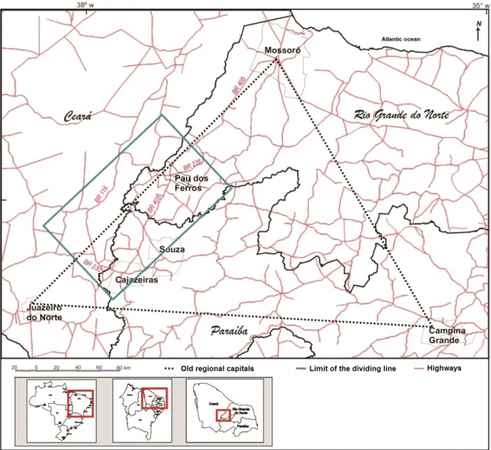
This characteristic of a service and commercial center has accentuated the role of intermedia-tion taken on by Pau dos Ferros and contributed to the development of its region that expands to the states of Paraíba and Ceará. Visualizing the logic that aggregates the border-region to the context of the urban-regional dynamic existing in the Upper West Potiguar, studies carried out by Dantas and Clementino (2013) and Dantas (2014), for example, already identify an area of convergence in the region of the Potiguar border of the three states headed by the municipality of Pau dos Ferros in Rio Grande do Norte and by the municipalities of Cajazeiras and Souza in Paraíba, which allows the consolidation of the internal border region (Figure 2).
This zone of convergence was studied with a methodology that sees a rectangle formed by municipalities that are ‘cut’ by federal highways that cross the interior of the states of Rio Grande do Norte, Paraíba and Ceará (BR-405, BR-226, BR- 230 and BR-116) and / or that are inside the ‘rectangle’ formed by the meeting of these highways. A zone of intense dynamics arises due to the rapid communication that BRs allow with this space in the interior, creating a kind of radius of in-teraction, fostering the dynamics of the border area.
Mercator, Fortaleza, v. 17, e17003, 2018
.ufc.br
Urban-Regional Dynamics in Internal Border Territories
in the intersection of the aforementioned BRs, is a junction of road routes and the traffic node7 of the
border region, acting as a strategic point for convergence with other centers beyond the RN border.
Figure 2 - The RN-PB-CE dividing line formed by road junctions Source: Dantas e Clementino (2013).
Other indicators used to understand the urban-regional dynamics of the Upper West Potiguar border-region, considering Pau dos Ferros as the polarizing center of this hinterland, are: 1) the analysis of residential data of students enrolled in undergraduate courses in the UERN, Pau dos Ferros Campus; 2) the analysis of the IEPend and the commuting flows of people for study and work as a way of comprehending the origin and destination of the mobility, to understand the existence of a regional receiving / polarizing center, which facilitates the integration of the urban-regional dynamic, as well as its performance beyond the borders of RN.
Regarding the analysis of data about the residential origin of students enrolled in undergraduate courses at UERN, Pau dos Ferros Campus, it was found that, despite the concentration of enroll-ments in higher education in Natal (70% in 2010) the capital of the state of Rio Grande do Norte, there had been a significant growth in students enrolled in the interior (MEC, 2011). Part of this (7) Traffic nodes arise at points where two development axes intersect, and may occur as far as the intersection of two simple
www
.mercator
growth was through the expansion of UERN, an important public higher education institution in the state, which has been offering postgraduate graduation opportunities in the interior since 1976. It was the first university to reach the Upper West Potiguar region.
Currently, the UERN Campus in Pau dos Ferros serves more than 2,000 students, distribu-ted among undergraduate (graduating licentiates, bachelors and technologists) and postgraduate (graduating specialists, masters and doctors) courses. It is the institution with the highest number of courses and students in the region. This institution stands out because it is the only one offering academic masters and doctorates in the region, making Pau dos Ferros the smallest municipality in Brazil, in terms of population, to offer a PhD course. UERN’s dynamics have attracted students that extrapolate the Upper West Potiguar’s internal border-region, reaching six Northeastern states (UERN, 2016), aspects for other studies to systematize and understand its logic.
The configuration of the Upper West Potiguar as a border-region is also clear when the enroll-ment in undergraduate education by municipality of origin of the students of the Pau dos Ferros Campus is verified (Figure 3).
Figure 3 - Undergraduate students matriculated at CAMEAM/UERN, by municipality – semester 2016.1 Source of map: IBGE Basemap, 2015. Source of data: UERN (2016). Produced by Rosana França, 2016.
According to Figure 3, of the 1769 students enrolled in UERN undergraduate courses in Pau dos Ferros, only 395 (22.3%) are from that municipality, and the remaining 58 municipalities that send students to the undergraduate courses in that institution are from the border region (07 from PB and 06 from CE). (UERN, 2016) This data allows the Upper West Potiguar to be understood as a place formed by the constant presence of the other, coming from different municipalities, states, professions, ethnicities, etc. In seeking access to the most varied types of services, the population of the border-region take and bring with them some of their values and customs, contributing to a
regional border identity characterized by its intense reconstruction through the conflicts and influen
-ces of others and the local sertanejos, as stated by Almeida (2005), when dealing with borders as places of otherness, for whom the presence of the other is a fundamental condition of the border.
Mercator, Fortaleza, v. 17, e17003, 2018
.ufc.br
Urban-Regional Dynamics in Internal Border Territories
According to IBGE data on commuting, in 2010 Pau dos Ferros ranked in 11th place in the state of RN and the 1st in the region of the Upper West Potiguar. Taking Pau dos Ferros as a pole, 20 municipalities in the area covered by the regional-border were selected, that had destination flows of more than 50 people to Pau dos Ferros in 2010. It was observed that, except for this municipa-lity, all others have a mobility rate (exit) higher than the attraction rate (entry), which corroborates the understanding of Pau dos Ferros as a convergent aggregate center of services in the region of Upper West Potiguar.
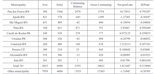
In order to understand not only the absolute weight, but also the relative weight of commuting8
for the municipality in the area of population convergence, some indicators traditionally used for the study of migratory flows were employed, such as: a) the net commuting rate, which helps to understand the impact that the commuting displacement inflows have on the total population of the municipality; and b) the commuting efficacy index (IEPend), which informs the position of each municipality in terms of its capacity to offer or attract labor; it ranges from -1 (high expulsion) to 1 (high attraction). Table 1 shows some commuting indicators among the municipalities with the highest flows.
Table 1 - Indicators of commuting for work and study: Region-border of the Upper West Potiguar (2010)
Municipality Exit Entry Commuting
Balance Gross Commuting Net pend rate IEPend
Pau dos Ferros-RN 388 3366 2978 3754 10.73811 0.793287
Apodi-RN 821 378 -443 1199 -1.27383 -0.36947
São Miguel-RN 451 409 -42 860 -0.18954 -0.04884
Patu-RN 160 631 471 791 3.93681 0.595449
Catolé do Rocha-PB 249 528 279 777 0.972125 0.359073
Uiraúna-PB 368 326 -42 694 -0.28799 -0.06052
Umarizal-RN 268 408 140 676 1.312213 0.207101
Pereiro-CE 309 334 25 643 0.160442 0.03888
Alexandria-RN 318 306 -12 624 -0.08905 -0.01923
Itaú-RN 301 302 1 603 0.01796 0.001658
Total 10+ 3633 6988 3355 10621 1.811447 0.315884
Other municipality 7959 4604 -3355 12563 -1.31042 -0.26705
Source: IBGE (2010)
Notes: 1) Net commuting rate = quotient of the commuting balance by the population total (in %). 2) IEPend = Quotient between the commuting balance and gross commuting.
According to table 1, Pau dos Ferros is the main dynamizer of the mobility flows of the Upper West Potiguar border-region in all the indicators presented. With an IEPend of 0.79 and responsible for almost half of the inflow of all the municipalities studied, Pau dos Ferros confirms its power to attract people to work and study, when there are municipalities with populations equal or superior to it, like Apodi, São Miguel and Alexandria, that have a significant population expulsion. Also in the border-region, the municipalities of Patu and Umarizal, in the RN; Catolé do Rocha, in PB; and Pereiro, in the CE, act to a lesser extent as receivers of flows, which may point to the existence of municipalities that function as micro-poles.
www
.mercator
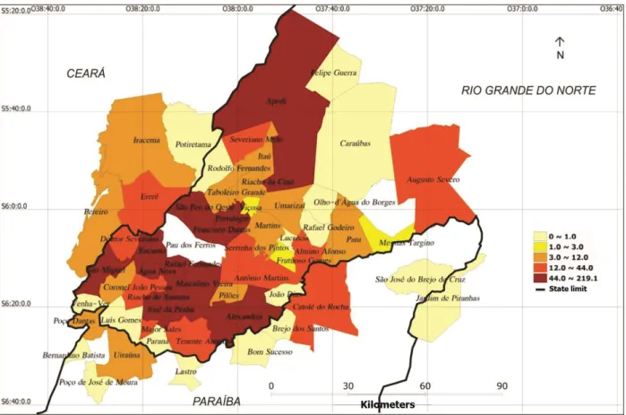
In addition to the IEPend, as an important indicator showing the regional-border polarization of Pau dos Ferros in mobility, Figure 4 and 5 below show the direction of work and study flows for
the municipality of Pau dos Ferros9 (IBGE, 2010).
Figura 4 - Commuting flows of people for work in Pau dos Ferros – 2010 (by quintile)
Source: Dantas (2014).
The 20% of municipalities with the highest flows of people for work (Map 4) are those on the immediate border of Pau dos Ferros and are on average 20km away, forming a kind of ‘circle’ around of the municipality. The municipalities that form the second quintile are located on the outskirts of the municipalities that make up the first, the municipalities of Ererê (CE) and Catolé do Rocha (PB) are in this group that also make up the border-region of the Upper West Potiguar. The last three quintiles have a mixed formation with municipalities from Ceará (Iracema and Pereiro) and Paraíba (Uiraúna and Poço Dantas), but also of several municipalities of the Upper West Potiguar, with an emphasis on Umarizal and Patu, which leads to an understanding of the Upper West Potiguar from its specific urban-regional dynamics resulting from the clear visualization of the commuting flows, and the mutual dependence between nearby territories that comprise its hinterland.
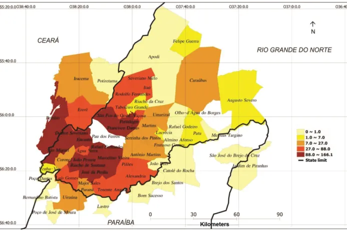
With the same intention of showing this mutual dependence in the territory of the Upper West Potiguar based on its flows, Map 5 shows the flow of people who move to study in Pau dos Ferros. It can be noticed that the 20% sending the most students to the municipality are the closest ones, including the municipalities of Doutor Severiano (RN) and Pereiro (CE).
Mercator, Fortaleza, v. 17, e17003, 2018
.ufc.br
Urban-Regional Dynamics in Internal Border Territories
Figure 5 - Commuting flows of people for study in Pau dos Ferros – 2010 (by quintile)
Source: Dantas (2014).
Small municipalities predominate in the second and third quintiles, located within an average distance of 50km, and that do not have public higher education institutions, except for Alexandria. The last two quintiles representing the 40% that send the fewest students to Pau dos Ferros are located more than 70km away and some, such as Apodi, Umarizal and Patú (RN) and Catolé do Rocha (PB), already have a supply of higher education.
The data on UERN’s area of coverage, the commuting indexes and the population flow maps, which indicate the mobility between municipalities in the border-region, with Pau dos Ferros as the polarizing center, indicate a regionally wide border. This border-region is made up of a Potiguar municipality that polarizes the urban-regional hinterland, mainly driven by the provision of education and work services in the interiorized northeastern urban network, corroborating the typification of the Upper Potiguar West as a border-region which, according to Geiger (1993), concerns the settlement of areas of low density in activities and populations, but which currently, due to its own constraints of space located between state boundaries, areas historically overlooked with the advance of the ecumene, today are experiencing a new phase of urban-regional development.
FINAL CONSIDERATIONS
The current process of reorganization of its productive structures based on the offer and ex
www
.mercator
In order to understand this process, we sought to follow paths that focused on understanding territory, borders and urban-regional dynamics to study how an internal border is articulated regio-nally from its polarizing center, going beyond the limits of RN and articulating municipalities from three different states. Quantitative data was used to identify the internal dynamics of the Upper West Potiguar by visualizing how the population converging on Pau dos Ferros is derived from the whole border context.
One of the peculiarities of the urban-regional dynamics that characterize the development of a border region, whose territory is located in the center of the Brazilian semi-arid, are noteworthy Upper West Potiguar: a) it is an area with a historically low population synergy and situated on the limits of federated states (internal border), which currently has social and economic dynamics, attracting the population from its surroundings in a dynamic commuting action; b) it is inserted in the interiorized northeastern inner urban network, fragmented and lacking some levels in the urban hierarchy, which hinders the formation of large centers; and c) its urban-regional dynamics are tied to the existence of Pau dos Ferros as a polarizing center that takes on a leadership role and subsidizes service infrastructures, motivators of attraction and population commuting in the whole border-region of the Upper West Potiguar.
In this border-region, Pau dos Ferros is also a municipality that attracts population to work and study, as proven by the data on commuting mobility, making the territory of Upper West Potiguar transcend historically constructed borders, becoming a region where the rural-city dichotomy is deconstructed to give space to new mobility flows, which are justified and defined by the regional load contained in the RN-PB-CE internal border.
The delimitation of the Upper West Potiguar as an internal border-region and the comprehension of how its urban-regional dynamics work permits an understanding of how the Brazilian economy has been configured and developed away from the major centers in an underdeveloped region with the lowest development rates in the country. It can also contribute to public policies in the develo-pment field at the local, regional and even national level.
Finally, studying and understanding how interiorized and semi-arid urban-regional dynamics work can contribute to the knowledge of a region in the interior of the country, in this case the Upper West Potiguar border-region, which is the study focus of the Postgraduate Program (PLANDITES) and different research groups that have recently settled in the region and will extend their studies and research in the semi-arid region. These studies also reveal the differentiated dynamics of the national metropolitan centers, since they are geared to the specificities of the interior of Brazil and the Northeast. Therefore, PLANDITES and other postgraduate programs located in the interior of the country need to understand these processes, especially in border contexts that bring to the dis-cussion the search for an understanding of these zones as hybrid territories, conflicted and energized by other actors and processes in this Brazilian west.
BIBLIOGRAPHIC REFERENCE
AB’SABER, A.N. Os domínios de natureza do Brasil. São Paulo: Ateliê Editorial, 2003
ALVES, L.S.F; LIMA, L.G.D. Culturas de Ordenamento Territorial do Município de Pau dos Ferros-RN. In:
ALBANO, G.P.; ALVES, L.S.F; ALVES, A.M. Capítulos de Geografia do Rio Grande do Norte - Volume
II. Natal: CCHLA-UFRN e Imprensa Oficial do Estado do RN, 2015.
ALMEIDA, M.G. Fronteiras, territórios e territorialidades. Revista da ANPEGE. n. 2, 2005. pp.103-114.
Consultado em: http://anpege.org.br/revista/ojs-2.4.6/index.php/anpege08/article/view/86/46
BECKER, B. Amazônia: geopolítica na virada do III milênio. Rio de Janeiro: Garamond, 2004.
BEZERRA, J.A. A cidade-região e sua incursão no estudo de espaços urbanos não metropolitanos. In. Anais
Mercator, Fortaleza, v. 17, e17003, 2018
.ufc.br
Urban-Regional Dynamics in Internal Border Territories
CASTRO, I.E. Geografia e Política. Rio de Janeiro: Bertrand Brasil, 2009.
CATAIA, M.A. A geopolítica das fronteiras internas na constituição do território: o caso da criação de novos
municípios na região Centro-Oeste do Brasil durante o Regime Militar. In: Scripta Nova. Vol. X, núm. 218
(22), 2006.
CLEMENTINO, M.L.M. Economia e urbanização. Natal/RN: Ed UFRN, 1995.
COSTA, W.M. Geografia política e geopolítica. São Paulo: EdUSP, 2008
DANTAS, J. R. Q.; CLEMENTINO, M. L. M. O papel das cidades (inter) médias para o desenvolvimento
regional. GeoUERJ, Rio de Janeiro, ano 15, n. 24, v.1, 2013 p. 228-255.
EGLER, C.A.G. et al. Bases conceituais da rede urbana brasileira: análise dos estudos de referência. In:
PEREIRA, Rafael H.M.; FURTADO, Bernardo A. Dinâmica urbano-regional. Brasília: Ipea, 2011.
Disponível em: http://www.ipea.gov.br/portal/images/stories/PDFs/livros/livros/livro_dinamicaurbano.pdf
GEIGER, P. Regiões fronteira no Brasil. Comunicação oral na Conferência Internacional de
Desenvol-vimento Regional: The Challenge of lhe Frontier. Ben Gurion University, Israel. 1993. Disponível em
<www.anuario.igeo.ufrj.br/vol17> Acessado em: novembro/2015.
HAESBAERT, R. O Mito da Desterritorialização. 6. ed. Rio de Janeiro: Bertrand Brasil, 2011.
IBGE – Instituto Brasileiro de Geografia e Estatística. Censo demográfico 2010. Rio de Janeiro: IBGE, 2010. IICA - Instituto Interamericano de Cooperação para Agricultura. Rio Grande do Norte. Secretaria de Estado
do Planejamento e das Finanças. Plano de desenvolvimento sustentável da região do Alto Oeste:
Parti-cipação da sociedade. v1. Natal, RN, IICA, 2006.
LEBRUN, G. O que é poder. 14º Ed. São Paulo: Brasiliense, 2003.
MACHADO, L.O. Limites e fronteiras da alta diplomacia aos circuitos da ilegalidade. Revista Território.
Rio de Janeiro, ano V, nº 8, 2000, pp. 7-23, jan/jun. Consultado em: http://www.revistaterritorio.com.br/ pdf/08_6_lia_osorio.pdf
MAX, C.Z.; OLIVEIRA, T.C.M. As relações de troca em região de fronteira: uma proposta metodológica
sob a ótica convencionalista. Geosul. Florianópolis, v. 24, n. 47, p 7-27, jan./jun. 2009. Consultado em:
<https://periodicos.ufsc.br/index.php/geosul/article/viewFile/2177-5230.2009v24n47p7/11700>
MEC – MINISTÉRIO DA EDUCAÇÃO, CULTURA E DESPORTOS. Expansão da Educação Superior,
e profissional e tecnológica: mais formação e oportunidades para os brasileiros. 2011. Consultado em:
<http://portal.mec.gov.br/expansao/images/apresentacao_expansao_educacao_superior14.pdf >.
MORAES, A.C.R. Território e História no Brasil. São Paulo: Annablume, 2008.
MOURA, R. Arranjos urbano-regionais no Brasil: uma análise com foco em Curitiba. Curitiba, 242p. Tese
(Doutorado em Geografia) Programa de Pós-Graduação em Geografia, Universidade Federal do Paraná, 2009. OJIMA, R.; MARANDOLA JR, E. Mobilidade populacional e um novo significado para as cidades: disper -são urbana e reflexiva na dinâmica regional não metropolitana. Revista Brasileira de Estudos Urbanos e
Regionais, Rio de Janeiro, v.14, n. 2, 2012.
RAFFESTIN, C. Por uma Geografia do poder. Tradução: Maria Cecília França: São Paulo Editora, 1993.
SANTOS, M. A Natureza do Espaço. 4ª ed. USP – Universidade de São Paulo, 2006.
UERN – Universidade do Estado do Rio Grande do Norte. Matrículas dos alunos nos cursos de Graduação