Título | Serial title
A OBRA NASCE
revista de Arquitetura e Urbanismo da Universidade Fernando Pessoa nº11, dezembro de 2016
Edição | Publisher
edições Universidade Fernando Pessoa Praça 9 de Abril, 349 | 4249-004 Porto Tlf. +351 225 071 300 | Fax. +351 225 508 269 edicoes@ufp.pt | www.ufp.pt
Conselho Editorial | Editorial
Editor-in-Chief:
Luis Pinto de Faria (Professor Associado na Universidade Fernando Pessoa) co-Editors:
Rui Leandro Maia (Professor Associado na Universidade Fernando Pessoa) Sara Sucena (Professor Auxiliar na Universidade Fernando Pessoa)
Conselho Científico | Scientific Advisory Board Antonella Violano (Facoltà di Architettura “Luigi Vanvitelli” della Seconda Università degli Studi di Napoli)
Avelino Oliveira (Professor Auxiliar na Universidade Fernando Pessoa)
Clovis Ultramari (Professor na Pontifícia Universidade Católica do Paraná)
Conceição Melo (Mestre em Projecto e Planeamento do Ambiente Urbano FAUP/FEUP)
João Castro Ferreira (Professor Auxiliar na Universidade Fernando Pessoa)
Luís Pinto de Faria (Professor Associado na Universidade Fernando Pessoa)
Miguel Branco Teixeira (Professor Auxiliar na Universidade Fernando Pessoa)
Paulo Castro Seixas(Professor Associado no ISCSP - Universidade de Lisboa)
Rui Leandro Maia (Professor Associado na Universidade Fernando Pessoa)
Sandra Treija (Vice-Dean of the Faculty of Architecture and Urban Planning of Riga Technical University)
Sara Sucena (Professora Auxiliar na Universidade Fernando Pessoa) Teresa Cálix (Professora Auxiliar na Faculdade
de Arquitectura da Universidade do Porto)
Composição
Oficina Gráfica da Universidade Fernando Pessoa
ISSN
2183-427X
Reservados todos os direitos. Toda a reprodução ou transmissão, por qualquer forma, seja esta mecânica, electrónica, fotocópia, gravação ou qualquer outra, sem a prévia autorização escrita do autor e editor é ilícita e passível de procedimento judicial contra o infractor.
45
Regeneration of Vlora waterfront promenade
Ani Cuedari
PhD student, Faculty of Architecture and Urbanism, Polytechnic University of Tirana, Albania
anicuedari11@yahoo.com
Florian Nepravishta
Professor, Faculty of Architecture and Urbanism, Polytechnic University of Tirana, Albania
f_nepravishta@yahoo.com; florian.nepravishta@fau.edu.al
ABSTRACT
This paper’s focus is the regeneration of the urban water-front promenade, strengthening its role in the resolution of specific seaside cities’ spatial and economic problematic. It is a descriptive and analytical study of the winner proposal for Vlora waterfront promenade, which aims to turn the city into a significant urban coastal area for regional rec-reation and tourism. It also strives to rely on a theoretical background on waterfront space redesigning, based on the European experiences in urban waterfront redevelopment and on the potential of their regeneration, as an instrument of economic development.
It concludes that since the waterfront redevelopment scheme is a complex, multi-actor and long-term program that has to cope with changing economic and political con-ditions, the planners should be very cautious of adopting elements of successful international examples, for reasons of uniqueness of local environmental, physical, economic and political preconditions.
KEYWORDS
Promenade; Waterfront Regeneration; Urban Development; Public Private Partnership
A Obra Nasce
46
1. INTRODUCTION
The second largest port city of Albania, Vlora1, is positioned
in a strategic location of south-western Albania, right where two seas, Adriatic and Ionian, meet. Considered as the jewel of Albanian Tourist places, Vlora is the portal of Albanian Riviera2. The city, surrounded by gardens,
vine-yards, and olive groves, giving the real southern Mediterra-nean sensation, stands in front of Karaburun Peninsula, 130 km from Salento’s coasts, in proximity to the port of Bari, Italy (Hutchins, 1974, p.474). Its Bay is strategically located in the axis of Sazan Island, near diverse sandy and rocky beaches and mountains of a scenic beauty. It is part of “Corridor 8”, imminent to the Adriatic-Ionian Highway and has a direct exchange with SH8 Highway. Vlora is located in a flat, saline land, partially covered by “Soda” pine forest. The economic development is based in different activities like industrial, processing, commercial, goods storage, light industry, electronics, auto parts manufacturing and port related ones (TEDA, 2015).
In ancient times, Aulón was born as a port, being at the same time famous for the trees it cultivated. It became an important waypoint between Apollonia and Butrint dur-ing the 4th century A.D., being mentioned progressively as
a landing port for ships of goods, coming from Otranto and Brindisi. The city was an important port of the Roman Em-pire, during the period of Epirus Nova. It became an Episco-pal center on the 5th century (Farlati and Coleti, 1817).
During the Middle Ages, the city was merged with Kanina fortress. Whereas during the 14th century, it became a
sub-stantial trading and handicraft center acknowledged for wines, salt, swords, ships, and silk. After the Turkish inva-sion3, Vlora regained its status as an important economic
center and port by the 17th and 18th centuries (Vlora
Munici-pality, 2015).
1 It was created in antiquity as a Greek colony in the territory of Illyria. Its first name was Aulón (Wikipedia, 2015). Italian Valona (Room, 2005).
2 Traveling in Albania, Tourism, Vlora. [online] Available: http://www. infoalb.net/02conavstivit/con_vlora.html [10/11/2015].
3 1417.
However, during the first half of the 20th century the city was only an intern urban center linked to the trade harbor (Skela) by a road exceeding through the fields. The harbor was connected with the salt production sites of Panaja by different railway tracks, vanished nowadays. These facts show that the city of Vlora was not faced to the sea since the beginning (Fig.1.a, b).
Fig. 1. (a) Road of ‘Skela’ (b) Seaside and the harbor of Vlora. Source: Private postcards
After the Italian occupation, in 1939, Italian architects re-viewed and designed many urban plans of Albanian cities. Gerardo Bosio and Ferdinando Poggi, in 1941, have designed the regulatory plan of Vlora (Vokshi, 2014, p. 268) to be an extensive city facing the sea front and connecting with the historic city (Fig.2). Regulatory Plan of Vlora includes the road network and construction areas throughout the space from the existing city to the “Uji i Ftohtë”. In this area it was fore-seen urban space with a capacity of 40.000 people, with the multi-storey residential buildings, with a rectangular road network and developed infrastructure. Also, the study pro-vides the construction of new harbor and some quays along the bay of Vlora, which would have a mainly tourist functions.
47
During the communism period, the seafront took its shape with the growth process of “Skela” quarter so called “Lag-ja Nr. 1” and beach resorts in “Old Beach”, especially in the north coast. The later development of the south coast led to a waterfront promenade. So in the ‘80s, with a voluntary contribution of some enterprises of the city, it was rehabili-tated a part of the coastline in the area of “Belvedere” near the tunnel and the New Beach at “Uji i Ftohtë”.
Project of the promenade along the seacoast of Vlora, have a long story. It starts with the vision of planners at the time of the fascist occupation of 1941 and start the implementa-tion later in the period of communism with the plans of 1973 (Fig.3) and 1996.
During the transition period the waterfront development lied in a context of formal and informal development. New
Fig. 2. Vlora Regulatory Plan of 1941 (G. Bosio and F. Poggi). Source: AQTN
Fig. 3. The regulatory plan of Center and “Lagja Nr. 1”, 1973. Source: AQTN
48
developments occurring after ‘90 have increased the in-formal constructions without complying with any kind of regulation or urban planning (Nepravishta et al., 2014, p.59). The regulatory plan of 1996 was elaborated in 2002 by the municipality planning office with a proposal for shifting the promenade toward the sea4. In 2004 the master plan of the
center, dealing with the Vlora waterfront, was approved by Territorial Adjustment Council (K.RR.T.R.SH.). This study de-termined that the road Skelë-Uji i Ftohtë along the sea will be 38m wide, proposes the creation of the promenade by filling the seaside and the return existing harbor, in yacht port. In 2011, preparing for “100th Anniversary of National
Inde-pendence”, the Project for the sea promenade was pre-sented by the Mayor Gjika. In May 2012, work starts for the realization of the project, a modest project, dependent on municipality budget. The first stage starts from the hotel “Bologna” to the former “Aulona” and the second phase of the former “Aulona” to “Uji i Ftohtë”. But this project doesn’t get the support and approval by the central government. The Minister of Urban Development and Tourism organized, in 2014, the international one-stage urban design compe-tition for the regeneration of Vlora Waterfront Promenade bracing the Albanian government’s and Prime Minister Edi Rama vision for its development, aiming specifically the rehabilitation of public spaces. The expected result was to demonstrate how urban regeneration projects could have a huge impact on the entire city life. The objective was to create space that improved tourism potentials but also created opportunities for small and medium economic en-terprises that could re-establish public investments in the city; trying to be low cost and large influencing at the same time (MZHUT, 2014).
The winner proposal for the Vlora waterfront competition was Xaveer De Geyter Architects (XDGA), in collaboration with the local MetroPOLIS Studio5 and Italian Engineering
4 The plan hasn’t been approved by the authorities.
5 Local studio prepared an analysis and in-depth report on the social, economic and urban development of the city of Vlora.
Studio IRD6. Although being the oldest touristic attraction
of the city, the Waterfront Promenade is visualized as a re-verberant pedestrian area with recreational spaces facing some of the newly inhabited parts of the city. The water-front development as a whole was tightly linked to the fu-ture of the two main infrastrucfu-tures: The port and the road to the south of Albania.
2. THEORETICAL BACKGROUND: REGENERATION OF URBAN WATERFRONTS
The earliest forms of waterfront development occurred where relief was conducive to harborage and shelter. For example, the Roman settlement of Londinium was estab-lished in 50 A.D. at the last bridgeable point on the River Thames. Subsequently, many more urban settlements have been established along waterfront areas, such as Falmouth, UK; Bahia, Brazil; and Mumbai, India; where particular sec-tions of riverside and coastline have provided natural har-bors, adaptable for marine activities.
The whole history of European cities shows that prom-enades became strategic tools that provided better living conditions. They turned into a place where people, other than walking, met other people and socialized with each other. From the 16th century Napoli and Palermo to 20th
cen-tury Barcelona, that became an icon for Mediterranean cit-ies, waterfront regeneration consists on a complex task, comprising a change of use, resuscitation and revival, rear-rangement and redesign. It is part of:
> Port planning: Inner development of the port (e.g.: reor-ganization and innovation);
> Town Planning: Change of use, a stroll from formerly port economic use to service, tourism, and living uses. Urban waterfront redevelopment has become a well-es-tablished phenomenon in western countries since the
de-6 IRD Engineering has studied the traffic and the impact that the new road will have on the promenade.
49
cline of old industrial harbors, returning them to the urban property market and also offering a great potential to boost the postindustrial transformation (Bender, 1993; Meyer, et al., 1996; Wang, 2003). Therefore, to some degree, water-front regeneration was seen as an urban panacea, a cure-all for ailing cities in search of new self-images or ways of dealing with issues of competition for capital development or tourist dollars (Marshall, 2001a, p.6)
Since the 1960s, waterfront redevelopment as a planning tool has consisted of different processes aimed at trans-forming. According to Shaw (2001), the evolution of this transformation can be seen in the light of four different generations of urban waterfront redevelopment. The first three generations cover what Marshall (2001) terms the ‘top 10 list’ in the waterfront literature, which comprises cases that have already become emblematic. The city of Balti-more with its inner harbor renewal plan is representative of the first generation along with other North American cities that pioneered waterfront revitalization efforts in the 1960s and 1970s (Millspaugh, 2001). The second generation con-sists of cities where organizations were set up specifically to plan, manage, and implement redevelopment projects during the 1980s. The cases of Boston (Gordon, 1999; Krieger, 2001) and Toronto (Desfor et al., 1989) are representative of such generation, which adopted and expanded Baltimore’s redevelopment measures. Correspondingly, the cases of London (Gordon, 1996) and Barcelona (Marshall, 2001) fea-tured urban renewal projects of considerable magnitude undertaken through distinctive market-driven planning processes and capacities. The third generation was marked by cities that assumed the measures developed by the first two generations, as the accepted mainstream waterfront redevelopment practice also during the 1980s. The Water-fronts of Vancouver, Sydney and Liverpool stand out as im-portant examples (Shaw, 2001). The fourth and more recent wave of waterfront redevelopment is characterized by cit-ies that started their developments after the 90s’ world-wide economic recession. The case of Bilbao is perhaps an illustrative example of this generation (Vergara, 2001) which portrays a synergy of spatial planning instruments, pilot projects, political will and public–private partnerships. All these factors have contributed in transforming radically the essence of the city.
Breen and Rigby (1996) assort redeveloped waterfronts into six groups: commercial; cultural, educational and environ-mental; historical; recreational; residential and working wa-terfronts. It is a “sometimes arbitrary grouping”; no water-front is exclusively commercial, educational, residential or working in nature. Many are “home” for a large variety of urban functions, flagship projects and commercial enter-prises. Balanced complementarity of functions and projects, including hi-level housing and services, cultural and crea-tive industries, fun shopping plazas and flagships of enter-tainment, appears a prerequisite for successful waterfront redevelopment. These formerly abandoned sites will be turned into dynamic nodes of postindustrial urban econo-mies (Bender, 1993; Breen and Rigby, 1996; Boer, 2005). To make this happen nowadays, redevelopment plans should include not only residential projects and advanced economic activities, but also appealing leisure and enter-tainment functions in eye-catching ‘packaged landscapes’, including: “museums of urban and industrial history, the kitsch historical adornments of many packaged landscapes and new developments such as industrial hardware re-cycled as forms of street furniture, the renovation of old buildings or districts providing commercial, industrial, rec-reational or residential property and the do-it yourself ren-ovations of inner-city gentrifies” (Hall, 2001 p.115).
Sometimes they remain underdeveloped, due to lack of long-term planning. According to Jauhiainen (1995, p.19), the contemporary objectives are “to create an image of a thriving city, to shift the city’s international rank and to get a larger piece of the ‘floating’ international investment for the city”. It is no question that leisure and entertain-ment in its broad definition, including for instance catering, museums, entertainment, fun shops, parks and historical heritage, are key functions in successful waterfront devel-opment (Breen and Rigby, 1996; Fagence, 1995; Groen and Oosterman, 2004).
The winning project of Vlora waterfront competition seemed to try accomplishing the design principles that have proven to be critical components of successful waterfront projects. As part of the existing urban fabric, it needed to secure the quality of water and the environment, let the historic identity
50
give character, make mixed-use a priority, make public ac-cess a prerequisite, speeding the proac-cess by planning in pub-lic-private partnerships, enhancing public participation as an element of sustainability, treating the intervention as a long term project, taking into consideration that revitalization is an ongoing process, profiting from international networking.
3. WATERFRONT CONTEXT
Vlora waterfront promenade is a segment of the long coastline7, including”Soda” forest area from west, till the
Tunnel area north direction with these main characteristics:
7 From Narta lagoon to the rocky shores on south, being visually connected to Sazan Island in the west.
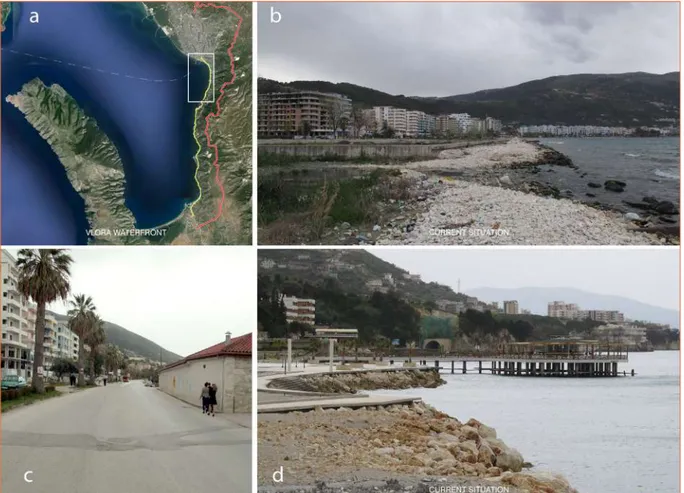
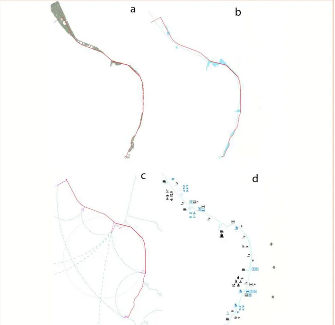
> 5 km long, which makes it one of the longest urban wa-terfronts in Albania (Fig.3.a);
> Proximity to the city center;
> A variety of development levels, ranging from well de-veloped; contemporary housing quarters, to devastated areas (Fig.4.b,c,d);
> Gloomy coastline, far from public use appreciated in cities with a similar waterfront on the Mediterranean Sea; > Scenic views and sunsets similar to Naples, Capri,
Marseille, etc.;
> Need to redefine its importance in the Mediterranean context;
Fig. 4. (a) Area of intervention - Vlora Waterfront (yellow) and Bypass (red); (b) (c) (d) The existing situation of Vlora Waterfront. Source: XDGA and Author
51
> The lack of proper infrastructure8;
> The nearness with the road9;
> Uncontrolled Urbanization10;
> Closeness of the Port toward the city;
Inappropriate interventions on the coast line, with private businesses, such as informal buildings, kiosks and bars, which are obviously an obstacle to the public areas and views to the sea.
4. THE COOPERATION CLIMATE AND PUBLIC PRIVATE PARTNERSHIPS
The waterfront area provides a range of opportunities for public and private investments. Nevertheless, the relation and access level of these properties are limited, due to le-gal and formal ownership, damaged infrastructure, etc. The waterfront contains two types of public ownership areas: the plots dedicated to public institutions and the area where public services are provided. There are 50 public lots located along the seaside, which belong to the public domain. They vary from 100-500 m2 and have good access to the main road. The total surface of the public space is 1.100 ha, almost 30% of the whole waterfront area (MetroPOLIS, 2014). The pedestrian road and beach area are public. Therefore, they are under the administration of the municipality. ‘Soda’ for-est is under the administration of the Environment Ministry, but is managed by the local government. The area of Marina School, the Regional Directory, the Orphanage, the Harbor, the Social Houses and the Tourist Camp are state properties,
8 The site area is fractionated in 3 main areas: The “Old Beach” area, the “Skela” area and the “New Beach” area; being without any organic connection with each other.
9 This can be noticed more in the “New Beach” area, which has not a wide line for public beaches. It brings a lot of problems like acoustic and air pollution for the pedestrian promenade and for the public beach nearby.
10 This can be noticed in the “Old Beach” area, where residential buildings are found without correct height regularity, positioned without a proper logic unifying them. There are also 1-2 floor buildings, which have accessibility difficulties.
therefore they are managed by the respective ministries or public institutions. Nevertheless, collaborations with these sectors are also possible, in terms of securing higher value for both, these institutions, and the promenade. In terms of use, some parts of the public beach are privately used (re-garded as semi-public), but not widespread, because most of the beach area is still public.
The real estate values along the waterfront vary according to the location, the access to the road and main public ser-vices, as well as the site typology11.
Nevertheless, many possibilities laid in unoccupied spac-es, such as the ex-Trade Camp, parts of the “New Beach”, “Rrape” and “Tunnel” area. It was also important interven-ing in the restructurinterven-ing process of existinterven-ing urban blocks, which were included in areas of low value. At this point, it was important establishing some instruments to control and benefit from the increase of existing land value. Most of the businesses were willing to cooperate with each other through a financial partnership, mostly with recrea-tional services, hotels, bars and restaurants, commercial services and business centers.
11 According to some data collected by the survey (MetroPOLIS, 2014) areas of lower value were respectively: ”Topana“ area near the hospital, hilly landscape, lack of accessibility, general old typology of housing, long distance from the sea (prices: 21.000 Euro/apartment and rent about 45 Euro/month), “Aviation Field” (least preferred area to live, real estate prices are really cheap), “Çole”/”Kume” (individual houses, renting for 75 Euro/month, close to “Skela” and the center), “Old Beach” (unoccupied space with the lowest value in the waterfront, buildings sold for about 450 Euro/m2 and the renting prices vary from 85-100 Euros, office spaces sold
for 800-900 Euro/m2, presence of a large surface of unoccupied space
with a small value of 75 Euro/m2) and the historical center of the city and
“Kushtrim”/”Lirim” (low prices due to new centralities shifting to the waterfront, selling prices: 38 000 Euro/apartment and renting prices: 98 Euro/month).
Areas of higher value were respectively: “Skela”, “Stadiumi”, “Centrale” and “Transballkanike” road (prices range from 42 000 Euros for selling to 85 Euro/month for renting); the areas of “Marina” (high urban density, no possibility to build new residences), “New Beach” (residencies sold for 650-700 Euro/m2 and offices for 2500 Euro/m2, potential for future residential
centralities of highest value, since there is still a lot of unoccupied land to develop) and “Tunnel” (Preferred for new residences, varying from 600-650 Euro/m2, with office spaces of about 2000 Euro/m2 and renting prices
52
Their average prices (as suggested by the business survey), are as follows:
> Hotels have a value of 550.000 Euros and can be rented for 10.000 Euro/month;
> Bars and restaurants are sold for averagely 210.000 Eu-ros and rented for 2.000 Euro/month;
> Stores have a selling value of 58.000 Euros and can be rented for 450 Euro/month.
This means that hotels are the businesses which would profit, so should contribute more in terms of providing fa-cilities for public use. It is expected a raise in land value and unoccupied land prices, due to the impact of the waterfront project, which will emphasize the need to find the instru-ments to control and benefit from this fact.
The cooperation climate was tested among businesses and inhabitants, the results are as follows:
> 19% of the inhabitants were willing to co-finance the waterfront project, in one way or another. Most of these people were residents of the area itself, espe-cially from the Tunnel and Cold Water area, as well as the New Beach area.
> 40% of businesses were willing to participate financially in the waterfront design and implementation project, especially hotels. The way they want to cooperate is through a public private partnership, or some planning instruments. Most of businesses are willing to cooper-ate with each other, through a financial partnership, mostly with recreational services, hotels, bars and res-taurants, commercial services and business centers. Given this cooperation climate, these forms of partnerships and agreements are possible:
1. Use of the conditioned intensity as a development instrument
This instrument can be used by the municipality in all newly developed areas, especially in the “Aulona” area, to have a possibility to increase number of floors or density, in exchange of the financing of green ar-eas, parks and recreational areas in the entrance of the waterfront.
2. Use of taxation as a regulatory instrument
> Betterment fees along the whole waterfront (The land owners pay according to the percentage of increased value they will acquire, and the payment is made dur-ing the implementation process of the project. This fee can cover a considerable percentage of the cost of the project).
> Lower taxation for hotels in the “New Beach” and “Tun-nel” area.
> Reduced taxation for small stores. 3. Public Private Partnerships (PPP)
> A public private partnership can be established with hotels and resorts near the beach, in order to man-age, maintain and create diverse services for organized beaches of a higher standard. These partnerships are suitable for possible resorts of the Old Beach Area and for small hotels in the Cold Water and Tunnel Area. > PPP for the development of business improvement
dis-tricts (BID). The partners agree to open businesses re-lated to cultural, traditional elements, etc, to create or enhance the identity of the city. Currently the only area that can be developed in this way in Vlora is the “Trans-ballkanike” road, if another transitory axis is created through the Aviation Field in the future and a possible extension toward the old beach and soda forest should be foreseen in a next phase (Fig.5).
53
> PPP with the Harbor Authority (the purpose is to move the walls of the Harbor and creating a stripe of di-verse activities, as an integrating point of the boule-vard and the promenade. The cases of integration of Harbors with recreational activities, even cultural ones, are proven to be successful, as is the case of Barce-lona Harbor. These services can either be organized as a stripe along the displaced walls of the Harbor, or can be integrated inside the Harbor, in an identifying design. The profit of private businesses would be transferred to the Portual Authority and the municipality would serve as a regulator.
> PPP in management of parking facilities.
5. REGENERATION OF VLORA WATERFRONT PROMENADE
The winning proposal of XDGA architecture studio consisted of different phases of conceptualization, as it was extreme-ly flexible in implementation and open to interpretation. These turned it into a valid instrument of urban intervention in the Albanian coastal area, serving as a potential pattern for other cities too. It was adaptable depending on finan-cial capacity, timing and expectations of the Ministry of Ur-ban Development, Municipality of Vlora and collective public opinion. The proposal tried to find a balanced solution for the road and waterfront of Vlora, taking into account the bypass for a viable traffic flow12, incorporating it in the
de-12 Starting from the most recent traffic counts.
Fig. 5. Possible partnerships for new functions. Source: XDGA
54
sign proposal. The decisions regarding the accessibility of the coast by car didn’t influence the current design propos-al. Informal houses and hotels along the existing highway could be largely maintained, possibly being legalized ac-cording to the wishes of the competent authorities, not be-ing an obstacle for the project (XDGA AS, 2014; XDGA, 2014). The project proposal reflected that specific reality of Vlora by implementing a mix of small and large scale
interven-tions, functioning well individually and together. The project was a framework for future urban growth, a solid structure where development could take place at a rate defined by economic and social conditions.
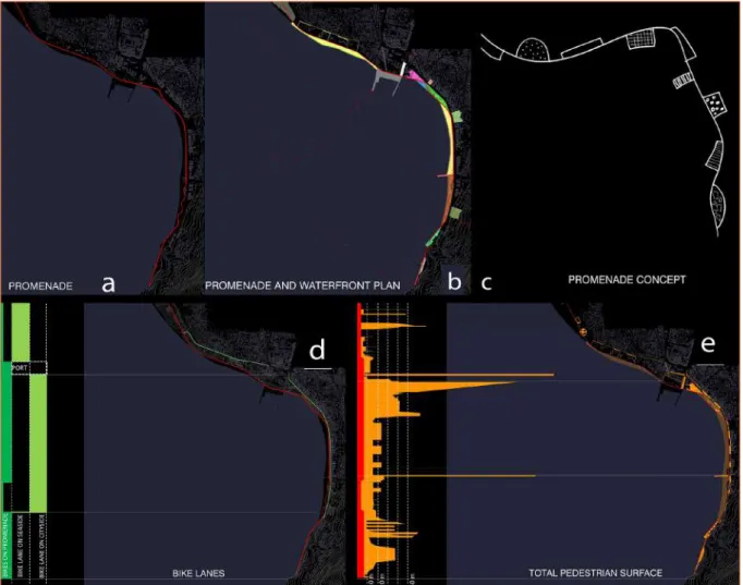
The developing plan included four different phases: Prome-nade and trees; Waterfront and points of interest; New links proposed in water and land; Different programs (Fig.6).
Fig. 6. (a) Promenade and trees; (b) Waterfront and points of interest; (c) Proposed new links in water and land; (d) Programs. Source: XDGA
55
The stages were tackled in a more focused way, for exam-ple through the creation of new white beach areas, sports grounds, swimming areas and water parks, a pier and a mari-na, new hotels, a floating island, etc. This design proposal was open to interpretation and extremely flexible in sequencing and implementation: an instrument of urban intervention in the urban coastal area of Vlora, in order to serve as a model.
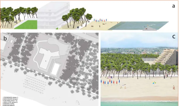
5.1. First phase: Promenade and Trees (preserving and amplifying the existing)
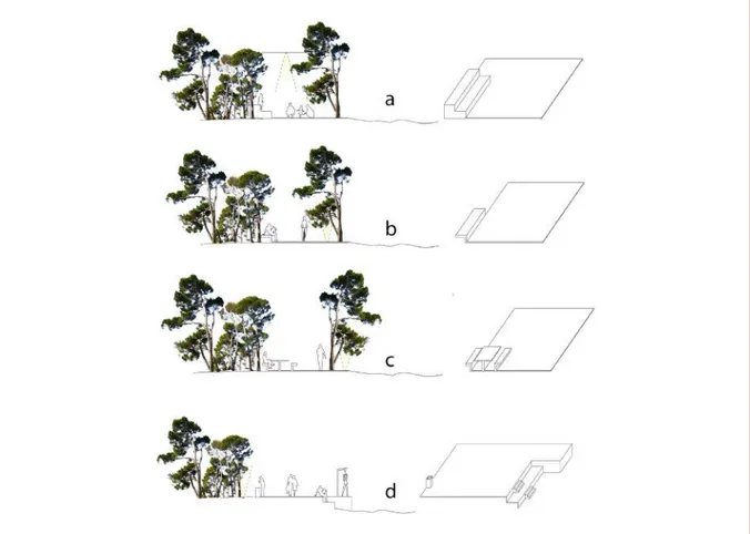
The first implementation phase, which led to an immedi-ate beautification of coastal land, was that of expanding the existing boardwalk and widening the typical vegetation
areas of the city13 along the promenade, over the full 5 km
long coastline (Fig.7).
These created not only a harmonious whole, but also a unique and specific identity for the coastal town, typical of Albania’s Mediterranean landscape. The boardwalk was a proposed construction in concrete, which varied in width along the way. It would achieve the widest dimension in ur-ban areas, and the narrowest (4 meters) in the natural ar-eas, minimizing the impact of the intervention.
13 Trees of “Soda” Forest.
Fig. 7. (a) (b) (c) (d) Promenade – pedestrian surfaces, bicycles and public space. Source: XDGA
56
This phase (important for the rapid improvement of the coastal strip’s quality) involved the implementation of ur-ban furniture elements and improvement of infrastructure, such as resourceful positioning of benches, showers, gar-bage bins, signs and lighting (located in the pavements or hung up in trees (Fig.8).
The 3-4 meters walkway was accessible by pedestrians and bicycles only. It concluded in a triangular shaped platform near the water, continuing into stairs that led over the tun-nel to the mountains behind. It also accedes a diving board, a mooring place for boats, a viewing point and a gateway to the hiking trail in the mountains. It was a launching platform to both the sea and mountains (XDGA AS, 2014; XDGA, 2014). The trees along the promenade provided a special char-acter and identity to the coastal town, unifying the
Medi-terranean landscape. Local trees such as “Aleppo Pine” (a pine native in the Mediterranean region), formed a visual and acoustic barrier along the highway, retaining the view onto the sea and offering shade underneath. This enabled the sheltering of different activities during almost all the year, due to their thin stems and broad, flattened crowns. They created a structure that effortlessly boosted the spa-tial quality of the waterfront. The extension of the existing tree line of the Soda Woods was planned along the entire coastline, harmoniously creating a unique image for the Al-banian coastal city (Fig.9).
The plantation was done alternately along, sometimes closer to the beach, sometimes into large quantities and sometimes widely spread, depending on the specificity of the area of the coastal widely area.
Fig. 8. (a) (b) White concrete path and bench, hanging and in-ground lights; (c) (d) Concrete path, picnic table and bin, metal shower. Source: XDGA
57
5.2. Second Phase: Waterfront and Points of Interest
The second stages included an integrating and upgrading implementation, handling the charge of certain areas in a more detailed manner. This stage went through the crea-tion of new white beach areas, central parking along the roads, sports grounds, swimming areas and water parks, a pier and a marina, new hotels, a floating island, etc. It was really important to educate a cooperative climate and collaboration with the private sectors in different types of partnerships (Nepravishta et al., 2014, p.3). The main reason this could be achieved, was the raised value that each pri-vate business or owner would gain, due to the new devel-opments. Despite the unity provided by typical vegetation and extension of the promenade, some areas can be ad-dressed in very different ways to create a variety of sec-tions and experiences. Most of the proposed sequences are transformations, or improvement of existing situations. From North to South, the following sections offer a differ-ent tourist/user attraction operator (XDGA, 2014) (Fig.10).
- Soda “Sports” Woods: This area includes the existing for-est and existing football field. It incorporates new sports grounds and fields among the trees, standing somehow isolated from the public sand area. The promenade slips through it, dividing the fields into two sides (Fig.11). - Amenities Campus: The zone with existing formal infra-structures retains the structure of a campus with buildings looking out onto the beach. The sea provides a floating is-land, a platform for swimmers and a dock for boats used by the tourists or locals for fun and leisure (Fig.12).
- Urban Renewal Area: The plantation of conifers is nar-rower in this area. It allows the development of the urban hinterland and the wide beach for sunbathers.
- Port: The port occupies a pivotal role in the intervention project. It is a tourist harbor for boats and cruise ships. Tourists are welcomed onto a grand square of marble tiles beneath a canopy, formed by the tops of planted trees.
Fig. 9. (a) Trees overview; (b) (c) Intervention - preserving and amplifying the existing vegetation along the promenade. Source: XDGA
58
Fig. 10. Phasing, programming, and lighting plan. Source: XDGA
59
Fig. 12. (a) Section of amenities Campus; (b) Amenities campus detailed plan; (c) The existing infrastructure as a campus with buildings. Source: XDGA
Fig. 11. (a) Section of the Soda “Sports” Woods; (b) Soda “Sports” Woods detailed plan; (c) In the existing forest with the existing football field, new sports grounds and fields are created.
60
- Plaza on the sea: This is an open square to the quay, full of trees. It offers a superb view onto the water and leads to a zone with large shaded gardens, providing space for differ-ent functions14 (Fig.13).
- Garden Strip and Sunken Square: The area of large shaded gardens and Sunken Square are close to each other. Their morphological space modulation met there a playful geom-etry in plan and elevation (Fig.14). It makes this area very special due to the experience of the tourist/user.
- White Sand Curved Beach: This covered a zone for the construction of a new, white ‘Copacabana’ style beach, with a beautiful view over the sea. This section was the most classic stretch of beach and coincides with an already es-tablished urban seafront, regarding to the buildings along the promenade, which continued at around 10 meters wide
14 Sports, recreation, etc.
at this section was the widest it could get along the coast-line (Fig.15).
An important factor for this area development was the beach nourishment,which included improvement of the re-lation to the sea, safe access and water quality across the waterfront.
- Vlora Pier: This includes the existing pier that was reno-vated and expanded with various activities such as pubs, restaurants, jetties, etc. (Fig.16).
- Shaded Beach: This was a more natural, wilder and green-er stretch of the beach. Trees stayed closgreen-er to the watgreen-er. On the other side of the road, naturally landscaped stairs led the way into the mountains scenery (Fig.17).
- Hotel and Sports Clusters: The expansion of the existing zone with hotels and restaurants needed to be structured and clearly defined by constructing a rectilinear square in the water as a public leisure and swimming area, which
Fig. 13. (a) Section of the plaza; (b) Plaza on the sea detailed plan; (c) The open square to the quay provided with trees. Source: XDGA
61
served to additional hotels, behind which, the row of trees continued (Fig.18). The sports cluster offered service to the whole area, but mostly to the hotels occupied by tourists.
- Mineral Beach Extension: Due to proximity to the existing highway, the beach was very narrow at this point and went nearer to the rocks. This area was extended by a staircase
Fig. 14. Plaza on the sea and Sunken Square detail. Source: XDGA
Fig. 15. (a) Section of the white sand curved beach; (b) White sand curved beach detailed plan; (c) White ‘Copacabana-ish’ beach. Source: XDGA
62
Fig. 16. Vlora Pier - renovated and expanded with activities. Source: XDGA
Fig. 17. Shaded beach detailed plan - natural beach and trees near the water. Source: XDGA
63
structure, directly into the sea. The platform at the top of the stairs offers a municipal swimming pool, sports grounds, and parking (Fig.19).
- Sea – Mountain link: A triangular walkway (3m), accessi-ble for pedestrians, was partly on water and partly on land. The part in the water was a Pantone that could be used as a diving board and as a mooring area for boats. This simple and light construction served both, as a viewing point and a gateway to the hiking trail in the mountains (Fig.20). By deterring the different zones on the coast, the use of the water was also more defined and intensified. Demarcations in the water allowed for diversification of use: swimmers, divers, boats, ferries, floating islands, jetties, diving boards, mooring areas and viewpoints. These various points of in-terest gave structure, sequence and rhythm to the entire coastline (Fig.21).
Important factors for development were also the beach nourishment, improved relation to the sea, safe access and improvement of the water quality across the waterfront.
5.3. Third Phase: Traffic Proposal (land and sea)
The various “points of interest” identified in the second phase, should be linked by the water ferry system. Light electric shuttle ferries enabled visitors to reach the differ-entiated sections of the waterfront easily while enjoying the view of nature: beachfront or mountainous. Traffic was planned to be controlled and fluid15 (XDGA AS, 2014) (Fig.22).
15 For example, by no parking directly on the main road; left-turn reservation lane; separated bus stops; no capacity change at the triangle junction.
Fig. 18. Sports cluster detail. Source: XDGA
64
Fig. 19. Mineral beach detail. Source: XDGA
This system also allowed an intelligent approach to parking, since Vlora topography and the existing highways made the available space reserved for parking: limited. The system linked these areas with zones where parking space could be easily organized. In fact, most parking could be organized in the amenities campus, from where the tourists could get on the jetty, shuttle ferry and choose the beach experience they desired. In the second phase a car park building could be organized in the amenities campus. Smaller parking are-as were created along the coare-ast, remaining consistent with the promenade, programming and topography (Fig.23). The design proposal was open to interpretation and ex-tremely flexible. It was an instrument of urban intervention in the coastal area of Albania in order to serve as a model. It was adaptable depending on financial capacity, timing, and needs of the Ministry of Urban Development, the Municipal-ity of Vlora and the collective public opinion. ‘Ad hoc’ deci-sions could be made regarding whether and when certain areas were being tackled.
6. THE IMPLEMENTATION PHASE
The implementation phase, still under construction, went under re-evaluation and small changes of the design pro-posal with the aim of improving the relationship of the resi-dential area with the coast. It is ready to give the water-front viability, life and activities it needs (Fig.24).
The project construction and management has created many problems like:
> Project changes and unfinished technical design; > Long lasting of construction works (first phase has to
finish in 2015);
> The use of inland materials used (tuff and pumice) by the construction company for the beach nourishment (instead of white sand proposed in the project);
65
Fig. 20. (a) Section of the mineral beach; (b) Mineral beach extension and sea-mountain link; (c) Views of the stairway structure between the sea and the mountains.
Source: XDGA
Fig. 21. (a) Physical links; (b) Urban activities; (c) Visual links. Source: XDGA
66
> Environmental pollution during the construction works; > Traffic congestion during the implementation phase. In
this respect, the decisions made regarding the acces-sibility of the coast by car did not have a great impact on the current design proposal: both the plans for a na-tional bypass to avoid traffic in this segment and the plans for an alternative municipal street that will make a traffic-free area in the South Segment possible, have to be implemented before the start of this project. As a result of the lack of managerial skills for the implemen-tation of Vlora waterfront regeneration project, since 2013, when demolition began paving the way for the project being implemented, the tourism in Vlora has been reduced. This has created depletions of revenue for the city and unemployment.
7. CONCLUSIONS
In conclusion, there are a few approaches to be considered: > It can be a challenge to largely improve the quality of a
built environment in the heart of Vlora city, while build-ing simultaneously between the sea and the center.
> Eventually, there is a vision for an urban tourism de-velopment in Albanian cities, which places them on the European urban map, as a distinct group of cities. > Since the waterfront redevelopment scheme is a
complex, multi-actor and long-term program that has to cope with changing economic and politi-cal conditions, the planners should be very cautious in adopting elements from successful examples (e.g. Baltimore or Barcelona), for reasons of protecting the uniqueness of local, physical, economic and political preconditions.
> Improvement of managerial skills is very important tool for the success of the project. Construction of auxiliary traffic infrastructure as Vlora Bypass and the new ring road of the city that will pass behind of the new housing blocks in parallel with the existing coastline would help to avoid traffic in the waterfront area, making feasible the proposal for transforming it in a promenade that will be used mainly by pedestrians.
> The regeneration of this area is an important invest-ment opportunity for the municipality in the future; as it will generate high income from taxes, land
trans-Fig. 22. (a) (b) (c) (d) Traffic predictions and solutions, propositions in typical segments of streets. Source: XDGA
67
Fig. 23. (a) Parking – short time solutions; (b) Parking – long time solutions. Source: XDGA
Fig. 24. Photographs of the implementation phase. Source: Author
ferring fees and employment rates for residents. It will bring the need for determination of a specific pro-cedure for Albania conditions, based on negative and positive international Public Private Partnership ex-periences for the development of business improve-ment districts (BID).
BIBLIOGRAPHY
Bender, R. (1993). Where the City Meets the Shore. In Waterfronts: A New Frontier for Cities on Water. In: Bruttomesso, R. (Ed.). International Centre Cities on Water.
Venice, Italy, pp. 32-38.
Boer, J. (2005). Waterfront Redevelopment: The City’s New Face, ING Real Estate, Statement on Real Estate, 9, Spring, pp. 6-12.
Breen, A. and Rigby, D. (1996). The New Waterfront: A
Worldwide Urban Success Story. New York.
Desfor, G., Goldrick, M. D. and Merrens, R. (1989). A political economy of the water-frontier: Planning and development in Toronto, Geoforum, 20(4), pp. 487-501.
Fagence, M. (1995). City Waterfront Redevelopment for Leisure, Recreation, and Tourism. In: S. J. Craig Smith (Ed.).
Recreation and Tourism as a Catalyst for Urban Waterfront Redevelopment. London, Preager, pp. 135-157.
68
Farlati, D. and Coleti, J. (1817). Illyricum Sacrum VII, 360B. In:
Acta Albaniae I, pp. 397-401.
Gordon, D.L.A. (1996). Planning, design and managing change in urban waterfront redevelopment, Town Planning
Review, 67, pp. 261-290.
Gordon, D.L.A. (1999). Implementing urban waterfront redevelopment, Ocean & Coastal Management, 42, pp. 909-931.
Groen, A. and Oosterman, J. (2004). Leisurevoorzieningen Bepalen de Sfeer. Bouwfonds Ontwikkeling, Dossier Waterfrontontwikkeling. Hoevelaken, Herfst, pp. 16-17. Hall, T. (2001). Urban Geography. In: Routledge
Contemporary Human Geography Series. Second Edition,
London / New York, Routledge.
Hutchins, R. M. (1952). Encyclopedia Britannica Inc. & University of Chicago. Great books of the Western World. Chicago, W. Benton, p. 479.
Jauhiainen, J.S. (1995). Waterfront Redevelopment and Urban Policy: the cases of Barcelona, Cardiff and Genoa,
European Planning Studies, 3 (1), pp. 3-23.
Krieger, A. (2001). Reflections on the Boston waterfront.
In: R. Marshall (Ed.). Waterfronts in Post-Industrial Cities.
London, E and FN Spon, pp. 173-181.
Marshall, R. (2001a). Contemporary urban space-making at the water’s edge. In: Marshall R. (Ed.). Waterfronts in
Post-industrial Cities, London/New York, SPON Press, pp. 3-14.
MetroPOLIS (2014). Vlora waterfront dynamics. Public
financing and partnerships, PPP – Vlora. Tirane, Polis press.
Meyer, H. (1996). Destad en de haven: stedebouw als
cultural opgave, Londen, Barcelona, New York en Rotterdam. Delft, Publikatie buro Bouwkunde.
Millspaugh, M L (2001) ‘Waterfronts as catalysts for city renewal’. In: Marshall, R. (Ed.) Waterfronts in
Post-Industrial Cities. London, E and F N Spon, 74-85.
MZHUT (2014). Vlora Waterfront. International Competition. [online] Available: http://www.zhvillimiurban.gov.al AND http://www.vlorawaterfront.al [Accessed 18 July 2015] Nepravishta, F., Manehasa, K., Pllumbi, D. and Marko, O. (2014). Waterfront planning for sustainable development of natural and archeological heritage. In: Devetakovi , M. and Haass, H. Fachkurs Werkzeuge und Methoden für die
urbane Wasserfrontentwicklung. DAAD, pp. 57-66.
Nepravishta, F., Meniku, J. Devetakovic, M. (2014). Waterfront regeneration through PPPs: The case of Vlora, Albania. In: Tenth International Miklós Iványi PhD & DLA
Symposium Architectural, Engineering and Information Sciences,
University of Pécs, October 20-21. [online] Available: https:// www.academia.edu/11514264/ Waterfront _regeneration_ through_PPPs_The_case_of_Vlora_Albania [Accessed 13 December 2015]
Olivetti, A. (2015). Vlora Waterfront Competition, A promenade for Vlora, Divisare. [online] Available: http://divisare.com/projects/253718
[Accessed 10 November 2015]
Room, A. (2005). Placenames of the World: Origins and
Meanings of the Names for 6,600 Countries, Cities, Territories, Natural Features, and Historic. McFarland &
Company.
Shaw, B. (2001). History at the water’s edge. In: Marshall R. (Ed.). Waterfronts in Post-industrial Cities. London and New York, SPON Press, pp. 160-172.
TEDA (2015). Technical and Economic Development Areas, Vlora. [online] Available at: http://www.teda.gov. al/?page_id=120 [Accessed 10 November 2015]
Vergara, A. (2001). New Millennium Bilbao. In: R. Marshall (Ed.). Waterfronts in PostIndustrial Cities. London, Taylor & Francis, p. 208.
Vokshi, A. (2014). Tracce dell’architettura italiana in Albania 1925-1943. Firenze, DNA.
Vlora Municipality (2015). The History of Vlora. [nline] Available: http://www.bashkiavlore.org/index. php?Itemid=79&lang=en [Accessed 12 November 2015] Wang, C. (2003). Waterfront Regeneration. City and Regional Planning. [online] Available: http:// richardkenyon.co.uk/planningsummerschool.org.uk/ pdfs/2003B017AU pdf [Accessed 10 November 2015] Wikipedia (2015). Vlorë, From Wikipedia, the free encyclopedia. [online] Available: https://en.wikipedia.org/ wiki/Vlor%C3%AB#cite_note-4 [Accessed 16 November 2015]
XDGA AS (2014). Vlora waterfront promenade. Urban design competition report to the Ministry of Urban Development and Tourism, fw 9003.
XDGA (2014). Waterfront Promenade. [online] Available: http://xdga.be/gallery/vlora-waterfront-promenade/ [Accessed 10 November 2015]