Deposited in Repositório ISCTE-IUL:
2019-03-18
Deposited version:
Publisher Version
Peer-review status of attached file:
Peer-reviewed
Citation for published item:
Ferreira, J. C., Lopes, A. L. & Albuquerque, V. (2018). Context-aware information in mobile devices. In Proceedings of the World Congress on Engineering and Computer Science 2018. (pp. 343-348). San Francisco: International Association of Engineers.
Further information on publisher's website:
--Publisher's copyright statement:
This is the peer reviewed version of the following article: Ferreira, J. C., Lopes, A. L. & Albuquerque, V. (2018). Context-aware information in mobile devices. In Proceedings of the World Congress on Engineering and Computer Science 2018. (pp. 343-348). San Francisco: International Association of Engineers.. This article may be used for non-commercial purposes in accordance with the Publisher's Terms and Conditions for self-archiving.
Use policy
Creative Commons CC BY 4.0
The full-text may be used and/or reproduced, and given to third parties in any format or medium, without prior permission or charge, for personal research or study, educational, or not-for-profit purposes provided that:
• a full bibliographic reference is made to the original source • a link is made to the metadata record in the Repository • the full-text is not changed in any way
The full-text must not be sold in any format or medium without the formal permission of the copyright holders. Serviços de Informação e Documentação, Instituto Universitário de Lisboa (ISCTE-IUL)
Av. das Forças Armadas, Edifício II, 1649-026 Lisboa Portugal Phone: +(351) 217 903 024 | e-mail: [email protected]
Abstract— This paper describes a novel approach for indoor location and integration of other services in a university campus using Bluetooth Low Energy (BLE) devices. These BLE devices broadcast a Bluetooth signal in a limited and configured range/area, thus functioning as beacons that provide useful context-aware information to nearby devices operating with custom applications. Such applications can interpret the received signals as location and provide a range of useful services to the end user (students, events attendees), namely, indoor location and navigation or personalized complex workflows that require the interaction of the end user with multiple services within the university campus.
Index Terms—BLE, Beacon, Mobile Device, Personalization, Context-aware information
I. INTRODUCTION
ontext aware experiences through wireless interfaces using remote devices have become more common in our daily activities and are triggering technology and business shifts. Given the proliferation of mobile phones, around 70% of the global population today use mobile phones and other wearable gadgets. Merging the ubiquity of mobile devices with beacon technology allows us to explore new opportunities in providing contextual services.
BLE (Bluetooth Low Energy) is a new approach to wireless communication with a large potential mainly due to its low power requirement and inexpensive characteristics compared with classic Bluetooth [1] [2]. These BLE small transmitters can act as beacons and are used to interact with mobile devices once they enter into their transmission range. Given the hyper-local and contextual capabilities of beacons, they are of immense value in indoor location as well as players in the university campus information broadcast. With the power of beacons, students and other visitors can now discover a host of experiences in the university campus – from easier campus navigation to personalized campus experiences that provide access to rich digital content on their mobile devices. Beacons with their ability to source customer data around physical locations, activities, time and personal interests, provide a huge window of opportunity to target the end users with personalized and contextual experiences to ensure efficiency in the use of the university services.
Manuscript received March 2018; revised April, 2018.
Joao C. Ferreira is with Instituto Universitário de Lisboa (ISCTE-IUL), ISTAR, Lisbon, Portugal and Centro Algoritmi (e-mail: [email protected]).
António Luís Lopes is with Instituto Universitário de Lisboa (ISCTE-IUL), (e-mail: [email protected]).
Vitoria Albuquerque is with Instituto Universitário de Lisboa (ISCTE-IUL), ISTAR, Lisbon, Portugal,
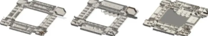
In this paper, we describe our approach for providing useful contextual services to the campus visitors – which include students, teachers, staff and events’ attendees – by using beacons and other information sources. These visitors are required to download a mobile APP onto their smartphone and have the Bluetooth on to interact with the beacons that are spread out across the campus. We explore the context-aware computing paradigm by combining the mobile device’s information sources and the beacons signals to gather location, time, identity, and activity data. We also use internal map information based on BIM – Building Information Models – which are 3D descriptions of buildings which associate information to the geometry of the building and its contents such as fixings, furniture or spaces. As an example, a parametrized BIM model is aware that a specific door is a double door, glass made, has level 1 fire-rating and connects to a specific location. This proves a major advantage because the BIM models are based on a database that can be queried and updated (currently not in real time) with information to and from the app. For example, see Fig 1.
Fig. 1. 3D section views of the BIM model of ISCTE-IUL’s Building 1 – Sedas Nunes
Mobile Apps detect and interact with Beacons in two main ways: 1) Region Monitoring - involves defining a region of one or a set of beacons using the UUID and/or major and/or minor values of the beacons. Similar to geofencing, region monitoring enables the application to push notifications when the smartphone enters or exits the defined region [3]. The unique ability of this interaction is that even if the application is not running, the application is launched in the background and the notification is pushed. An example of its real-world application includes a user being instantly notified about the current deals as they enter the store; 2) monitor which operates in a region detecting individual signals and estimating their proximities to the smartphone. It is important to note that iBeacon provides information about proximity and not exact location; iBeacon can answer what items are nearby but not where you are. Absolute location is a fixed location defined by longitudes and latitudes or some form of the coordinate system. In our approach, we georeferenced beacon installation in our BIM models and used that information to detect an approximate location of the user’s device.
Since most smartphones now support detection of BLE, it can estimate proximity to the beacon by using the signal strength to calculate Received Signal Strength Indicator (RSSI). The stronger the signal, the closer the beacon is to
Context-Aware Information in Mobile Devices
Joao C. Ferreira, António Luís Lopes, Vitoria Albuquerque
the smartphone. Since BLE does not require the smartphone to pair with the beacon, it can receive signals from multiple beacons. It infers which beacon is nearest to it by measuring and comparing their individual RSSI. Using iBeacon and RSSI, smartphones can also approximate the distance from the beacon. iBeacon signal transmits Measured Power (8 bits) which is a factory calibrated read-only constant for the expected RSSI measured 1 meter from the beacon. Using this constant and the RSSI, an estimate of the distance between the receiver and the beacon can be calculated [4]. This calculation of the distance can be inaccurate if there are a lot of obstructions within the room which can dampen the signal strength, but the combination of signals from multiple beacons can help reduce these inaccuracies.
Main problems associated with beacons are: 1) interference in signals due to obstructions in the area which can significantly affect the range of the beacons. Therefore, the positioning of the beacons is important, and they should preferably be placed on ceilings or walls at a height higher than that of an average adult; 2) security – even though beacons do not transmit any sensitive information, they transmit their identifier without any encryption. These identifiers can be detected by any smartphone and used by a competitor or malicious group in their applications.
II. BEACON TECHNOLOGY
The Beacon technology is a great improvement on the past solutions that have aimed to provide location as context. Beacons are small, cheap and do not require additional hardware. The main market for Beacons is surely advertising and marketing.
One prime example is Macy’s deployment of 4000 beacons in stores throughout the U.S during the holiday season in 2014. Using beacons, retailers can send customers notifications about product specifications, videos of how to use products, coupons, and deals. Retailers can also use the technology to monitor movements and patterns of costumers within the store to improve product placements and personalize notifications based on past purchases [3]. Airports and airlines have also taken up the technology. Virgin Atlantic set up beacons in the Upper-Class Wing at London’s Heathrow Airport in May 2014. They offered a variety of services including personalized duty-free and currency exchange offers to passengers and alerting passengers to prepare their boarding passes as they near security check-ins [3]. Japan Airlines also continued the trend in Tokyo’s Haneda Airport Domestic Terminal 1. By setting up an indoor positioning system, the terminal allows airlines to locate staff members equipped with smartphones and assign location-specific tasks to them [3]. American Airlines also deployed a trial run at the Dallas Forth Worth Airport in June 2014 to help passengers navigate the airport by providing them with information about distances to gates, boarding times and security check lines. In the sporting world, Major League Baseball (MLB) took up the opportunity to provide location-based advertising as well. In March 2014, it set up beacons in 28 of its 30 ballparks around the U.S. Through the MLB application; sports fans receive offers for merchandise coupons, information on concession stands and history of the venue, ability to check-in and even video clips of game replays. MLB reported that the number of check-ins tripled from 2014 to 2015 and that
it is looking for ways to add to the application to further enrich the experience of the fans [3]. Starwood Hotels & Resorts is running beacons in 30 of its hotels and resorts. The beacons are helping the concierges in greeting guests by name and accelerating the check-in process for frequent guests. It has also implemented a pilot program that will allow Starwood guests at two of their U.S. hotels to skip the check-in process and along with a partner application unlock their room door using their smartphones [3]. After being popularized by Apple and big brands, local businesses and institutions have also started using iBeacon technology to aid in their services.
In the famous Antwerp museum in Belgium, visitors are directed towards exhibits and notified about stories behind the exhibits. The beacons also stimulate interaction with visitors through interactive trivia questions [5].
In Bucharest, Romania, public transport is employing beacon technology to make the city more accessible for visually impaired citizens. Instead of having to rely on a friend for help, visually impaired citizens, using a mobile application, can now be notified by voice output when their bus pulls up and be directed to it through the station [6]. Depending on the beacon protocol used, payload can include:1) beacon ID (Estimote Monitoring, iBeacon, Eddystone, Nearable protocols); 2) Measured Power (Estimote Monitoring, iBeacon, Eddystone, Nearable); 3) sensor data (Eddystone, Nearable); 4) battery level and telemetry data (Eddystone, Nearable); and 5) URL address (Eddystone).
III. CONTEXT-AWARE COMPUTING
A formal definition of context-aware computing is defined by Gartner IT as “a style of computing in which situational and environmental context about people, places, and things is used to anticipate immediate needs and proactively offer enriched, situation-aware and usable content, functions and experiences” [7].
Identity, activity, time and location characterize primary context types of a situation that answer to questions related to the main aspects of the system [8]: 1) Identity (Who) identifies the social context of: Who is the user? Who are the people with which the user is interacting, or who is nearby? ; 2) Activity (What) relates to the function context: What is the user doing?; 3) Time (When) defines the temporal context: What time is it?; and 4) Location (Where) addresses the location context to the most widely used type of context, raw location or higher level: Where is the user? Home? Work? Bathroom? Coffee shop?
Secondary context types derive from these, not necessarily all four, and relate to categories such as distance and relationship.
All four primary context types do not need to be gathered to define context awareness. It mostly depends on the system developed and on the offered function.
This chapter focus on using location as a context which in its broader sense is not just limited to the geographical location but also the objects that build up the surrounding environment. Mobile applications which are context aware can find nearby objects and take advantage of this contextual information. Such applications can anticipate the potential needs of the user and act accordingly in advance, thus providing the real-time user information when and
where they need it without having to manually search for it [13].
Proactivity, invisibility, adaptation, security, and privacy are the main benefits of context-aware systems [9]:
• Proactivity: To ensure that a proactive solution is designed correctly it needs to be effective in tracking and recording the user’s behavior. Invisibility and transparency need to be ensured to not disturb user’s interaction. The user’s activity and how he wants to achieve it can be collected by a context-aware system and retrieved to determine the user’s next action.
• Invisibility: A manual system would require the user’s input, hence a system lacking in transparency. Minimum intrusion in user’s life is required to ensure systems’ invisibility. Context-aware systems collect and retrieve user’s environment and behavior without interfering with the user, therefore remaining invisible to the user.
• Adaptation: Collected information about the user’s context determines efficiency and effectiveness of the system’s adaptation to the environment. Differences between the demand and the supply of resources in a system require an adaptation strategy to quickly respond with an alternative strategy.
• Security and privacy: User recognition and authentication should be ensured to validate user information. Successful verification happens when knowledge factor and possession factor are cross-referenced and match user information [10].
How the information is presented and how it can be accessed determines accessibility of an interface. The dynamical adapting to the user’s context of the interface is crucial to the success and benefit of the user and system. Benefits on commercial areas rely on users to identify zones of interest and add comments of behavior preferences about zones, products, and brands.
The system tracks people in indoor environments and senses information about location, product and branding awareness displaying this information on the user’s app.
Data collected from purchasing behavior and customer’s trust – personal characteristics - in products and brands provide more accurate information and better recommendation about products and brands.
IV. MOTIVATING USE-CASES IN A UNIVERSITY CAMPUS
In this chapter, we present the use-cases that we explore using the technology described above. These use-cases focus on the interaction of the campus’ visitors with the facilities and services. These visitors can be first-time enrolling candidates, ongoing students, faculty staff or attendees of a specific event that takes place in the University.
New students enrolling for the first time
First-year students can be overwhelmed by the experience of arriving in a large campus and having to deal with the bureaucratic aspects of the enrolling process. In particular, the enrolling process requires them to interact with three different services (enrollment, payments and card issuers) that may be distributed across the campus. A mobile app that uses its owner’s contextual information and the interaction with the locally-installed beacons can help these new students not only by explaining the order in which the steps should be executed but also by helping them navigate
through the campus to the next location in the process. The mobile app can even inform the person if some of the steps are unnecessary if they have already been done online.
Ongoing Students
A large University campus that has grown throughout the ages tend to create labyrinthic networks of buildings, corridors, and rooms. Even senior students may have difficulty navigating in the campus when it’s time to go to the next class. A context-aware based mobile app can use the information on the student’s weekly class schedule along with the detection of their location as they arrive at a specific point in the campus (by detecting the signal of one of the beacons) to notify the student of where the next class will take place and provide them with the necessary navigation instructions to travel to that specific room.
Event Attendees
It is very common for Universities to host different kinds of events, ranging from conferences, workshops, training sessions and other large gatherings of people. Facing the same challenges of new students, the navigation on-campus for events’ attendees is difficult, especially for first-time visitors. An example of the use of this context-aware technology combined with beacons is the real-time availability of useful information for these visitors. For example, a visitor arriving to attend a specific event can be notified of the location of (and navigated to) the cloakroom to leave there some of their belongings (especially if the app can detect that it’s a particularly cold or rainy day). On arrival, the visitor can also be notified of current ongoing events and is asked to choose the one which they are attending (or maybe this information can be collected from the user’s calendar). This will allow the app to automatically check-in the person at the event (if the details provided by the app match the details of a registered attendee), quickly deliver useful information regarding the event (such as the schedule, room locations, WiFi details, etc.) and navigate the visitor throughout the campus for the multiple sessions locations (if that’s the case). The contextual aspect of this approach has the advantage of adapting to unexpected changes in the event organization, such as room changes, session delays or rearrangements. Beacon technology can also be used to advertise what sessions are taking place in nearby locations, in case that is of interest to the visitor or to notify of sudden changes in the schedule.
Efficiency in general
The use of beacons and other sensory technology can help provide accurate and near real-time monitoring of certain aspects of the campus activities, such as the use of some of the University’s services and facilities by students and other visitors (secretariats, academic services, class rooms, common study rooms, library) and consumption of energy and water. This helps facility management teams deploy the necessary interventions in particular parts of the campus and can provide useful information to emergency teams in case of an evacuation. The use of broadcasting features of beacons can also help avoid using too much paper to produce leaflets and other printed information documents.
Emergency Evacuation Guidance
Bluetooth Low Energy (BLE) Beacon to assist the emergency self-guiding evacuation using devices for crisis and emergency management to avoid panic condition inside the buildings. In this approach, the emergency light and exit sign with the BLE beacons deployed in the indoor
environments and the smart devices detect their indoor positions, direction to move, and next exit sign position from beacon messages and interact with map server in the Internet / Intranet over the available LTE and/or Wi-Fi network connectivity. BIM and routing algorithm generate an optimal emergency exit path according to the nearest emergency exit based on a novel graph generation method for less route computation for each smart device. All emergency exit path data interfaces among three system components, the emergency exit signs, map server, and smart devices, have been defined for modular implementation of our emergency evacuation system.
Library guidance to books and alerts of books arrivals –
Beacons can create a diversity of solutions in a library, such as: 1) Alerts about specific books in a shelf can be sent to students\teachers that are in a range of a shelf beacon (configured in a low range); 2) Navigation support – Beacons, together with map integration guide persons to exact location of the book; 3) information about book delays when the library beacon signal is detected; 4) info of desirable book in the library.
V. SYSTEM ARCHITECTURE
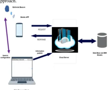
To achieve these goals, a generic architecture was implemented, illustrated in Fig. 2 based on beacon approach.
Fig. 3. The high-level vision of the currently implemented approach
The mobile APP is used to detect and interact with Estimote beacon using Ranging and Monitoring mode and sending HTML requests to access resources available on the cloud web server using URLs.
A Web API which publishes RESTful services containing data from the database is used by the mobile application client to fetch and display content. BIM models were implemented using the approach described in [11].
A Mobile App was developed based on Android Studio with an integrated development environment (IDE) for Android platform development. The App is developed for beacon interaction and for sending HTML requests to access resources available in the server using a pre-defined URL structure. The App was tested on a Google Nexus 7 tablet. We used beacons from Estimote, which has a powerful SDK for Android that provides the necessary modules to interact with Estimote Beacons. From the SDK we need to import BeaconManager, which handles all interactions with
beacons, allowing to define a region of beacons using their IDs.
A. Routing Algorithm
To provide navigation on this beacon-based app, we used a simplified implementation of the A* algorithm. The goal is to calculate the lowest route/path cost from the current/initial point, which is called node, to the destination node out of one or more possible nodes. It is based on an evaluation function: f(n) = g(n) + h(n). The h(n)
is the optimal path cost estimate from node n to the destination node and g(n) is described as the current cost from the current/initial node to any node n, i.e., the optimal path cost finding. As A* traverses the map, it follows the path with the lowest cost while keeping alternative nodes in a sorted priority queue. If a node being traversed has a higher cost than another encountered node at any point, it discards the node with the higher-cost and traverses the lower-cost node instead. This process continues until the goal is reached. The provided map can be configured with two types of components: nodes and obstacles. Each node provides a cost, depending on the initial and destination node but for obstacles, no cost is provided, so the A* doesn’t keep it in its queue.
B. BIM models
Building Information Modeling (BIM) provides a data-rich, object-oriented, intelligent and parametric digital representation of the facility, from which views and data appropriate to various users’ needs can be extracted and analyzed to generate information that can be used to make decisions and to improve the process of delivering the facility [12]. Internal building information can be extracted from this model and visualization is provided. Implementation of indoor positioning using BLE beacon signals and complement their position information with maps gives major results and enhancement in location estimation using error. Visual 3D information and information layers can give useful information in users’ guidance process.
We create a series of services that involve detecting a user’s location, in a geo-targeting process to achieve personalization. The implementation of this application based on the proposal approach of the beacon with BIM models can save time on guidance process.
C. Beacon configuration and interaction
As mentioned before, Beacon monitoring is used to notify the mobile device when it enters or exits a region of Beacons. One of the key features of Beacon Monitoring is that it functions even when the application is running in the background. BeaconManager provides built-in methods that aid in monitoring with beacons such as: 1)
startMonitoring and stopMonitoring serve to schedule monitoring; 2) startMonitoring is always running which allows the application to constantly scan for Beacons in the background. stopMonitoring is only used when the battery of the mobile device is in consideration. In real-life installations the region will be defined by those beacons that are present near the entry and the exits. setMonitoringListener scans for Beacons in the area which are included the predefined region. The Listener passes the event to one of the following methods:
onEnteredRegion or onExitedRegion which pushes a notification to the mobile device.
VI. DEVELOPED APP
Considering the architecture defined in Fig. 3, applications were developed for context-aware information in a university campus. The indoor topic guidance is used to create an APP for conference events guidance and for new students at the university. Context information is delivered automatically in the APP for food recommendation and news notification. A hybrid approach is applied to library where guidance and context information is delivered to users inside the library.
A. App for conference events
In this section we describe the App used for conference events, where an indoor location system combines user position collected by beacon interaction with map information in BIM models and a routing algorithm. Main actors are the:
1. administrator, with the role of beacon configuration (range, registration, pooling period, georeferenced in a BIM model) and cloud web server information managing;
2. Conference attendee, whose role is illustrated in Fig 3. They need to turn on Bluetooth, download the App, search direction and get information.
Fig. 3. Use case for conference attendance users.
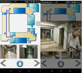
Main use is to provide conferences attendees guidance towards the room for each session, the registration process, lunch and break information. An example is illustrated in Fig 4, where guidance to a conference room is provided considering user position. Additional help is provided with 3D visualization maps.
B. Library APP
A Smart App is developed to provide easy access to library users with a Bluetooth-enabled smartphone or tablet in an indoor environment without GPS access. When a user goes in or out of the library, the App detects this behavior based on beacon signal coverage. The user can see the basic information about a book that he’s looking for on the mobile screen, where it is located and help navigate to it. It is possible to receive notifications regarding pre-defined books (new arrivals or book that are free to pick) when the APP detects the library beacon signal (short distance to library, we configured it as 25 meters). The developed approach is illustrated in Fig. 5, based on a beacon in the entrance of the library and five beacons placed inside to give context information. For example, the beacon on the computer science section is configured with a range to cover this section, and when the users are in this range, they
receive notifications/information related to computer science books. Also, navigation towards the desirable book is possible with beacon location combined with BIM models where maps provide user guidance.
Fig. 4. Orientation path to a conference room (left) and checking Path Confirmation Photos (right).
Fig. 5. Overview of Library installed approach
Fig. 6. Library APP, screens to identify user movements towards library or out.
As illustrated in Fig. 6, we can identify movements towards the library and with that, estimate the number of persons in range (persons with Bluetooth on in their device)
Fig. 7 shows App screen of searching for books in a context scenario because it uses beacon location. In this case, since it was the computer science beacon that was detected, the search only includes books in the computer science catalog.
Fig. 7. Context book search based on current location provides by beacon range signal
C. APP for News Notification
With beacons located at each university entrance, a set of university bulletins and news, for example for sustainable information or environment-friendly related advice or general interest subjects, is automatically configured to be sent to the users based on beacon detection that directs mobile App to a web server with related information. Personalization can be performed using Bluetooth Device Address (BD_ADDR) and relation with a student ID. This approach has privacy issues but is only used to send personalized information. When an end user subscribes to the mobile advertisement service, an association between his/her BD_ADDR is stored in a database in the web server. When the web server receives a request from a Bluetooth Sensor, it scans the database for known BD_ADDRs in the request that can be mapped to user accounts. Then it checks if there are any undelivered advertisements associated with the user account and the location identifier that was passed in the request. This can be used to alert to certain irregularities that need to be addressed with academic services and avoid the repletion of information messages. This is an experimental system for delivering permission-based location-aware mobile advertisements to mobile phones using Bluetooth positioning and WAP Push delivery.
D. Food Advertisements
We use the same approach when the user’s mobile App detects food court beacon signal. In this case, we send information about available food menus and use old user food data history to advise the user on healthy choices. This personalization is achieved by getting BD_ADDR. We are working on a new project to combine this approach with sensors on users, NutriSpace (H2020 submitted project).
VII. PASSIVE USER MOVEMENTS TRACKING INSIDE THE CAMPUS
These beacons interaction with mobile devices allows seeing student and general person movements inside the campus. Study movements patterns, identify preferences and can be useful information in emergency situations. In addition to real-time mapping, beacon data can also produce historical heat mapping to see hot spots across any of the locations and then use the data to optimize flows and
resources. Understanding employees are positioning and movements are very important across a range of industries. Using beacons to track campus person movements we can identify patterns, check where students spent most of their time, analyse constraints, estimate number of persons in the campus with a week time frame associated. We are working in the creation of heat maps for illustrating persons movements inside the campus, like it is illustrated on Fig. 8, which was adapted from previous work on position clustering [14].
Fig. 8. Heat map clustering approach applied to persons movements. Red zone means more people pass here and these zones corresponds to main entrance.
VIII. CONCLUSION
The goal for this work was to conceptualize context-aware digital services in a university campus and proofs of concept were developed to demonstrate the implementation of context-aware digital services using beacons, mobile device Apps and maps.
REFERENCES
[1] Bluetooth Low Energy — Bluetooth Technology Website. https://www.bluetooth.com/what-is-bluetooth-technology/bluetooth-technology-basics/low-energy.
[2] Carles Gomez, Joaquim Oller, and Josep Paradells. Overview and Evaluation of Bluetooth Low Energy: An Emerging Low-Power Wireless Technology. Sensors, 12(12):11734–11753, August 2012 [3] Apple Inc., Getting Started with iBeacon,
https://developer.apple.com/ibeacon/ Getting-Started-with-iBeacon.pdf.
[4] Galen Gruman, Beacons are harder to deploy than you think, http://www.infoworld.com/article/2983166/bluetooth/ beacons-are-harder-to-deploy-than-you-think.html.
[5] David Nield, iBeacon technology powers a new Smart Public Transport project in Bucharest, http://www.gizmag.com/ ibeacon-smart-public-transport-bucharest/37901/.
[6] Serena Chu, Apples iBeacon Tech Brings Art Gallery To Life, http://www.psfk. com/2014/01/apple-ibeacon-rubens-house.html. [7] Gartner IT, Context-Aware Computing,
http://www.gartner.com/it-glossary/ context-aware-computing-2/
[8] Anind Dey and Gregory Abowd, Towards a Better Understanding of
Context and Context-Awareness,
ftp://ftp.cc.gatech.edu/pub/gvu/tr/1999/99-22.pdf.
[9] Context Awareness – Why is this characteristic important to applications in a ubiquitous computing environment?
https://pdfs.semanticscholar.org/ae4f/eb7b2b07f8413a5b7b511ff6b31 a927bcf01.pdf
[10] Al-Muhtadi, J. et al., 2002. A flexible, privacy-preserving authentication framework for ubiquitous computing environments. In Distributed Computing Systems Workshops, 2002. Proceedings. 22nd International Conference on. pp. 771–776
[11] Lin Y-C, Su Y-C. Developing Mobile- and BIM-Based Integrated Visual Facility Maintenance Management System. The Scientific World Journal. 2013;2013:124249. doi:10.1155/2013/124249. [12] Associated General Contractors of America. (2005). The Contractor’s
Guide to BIM, 1st ed. AGC Research Foundation, Las Vegas, NV. [13] Lopes, A. L., Costa, P., Bergenti, F., Klusch, M., Blankenburg, B.,
Möller, T....Schuldt, H. (2006). Context-aware Secure Service Composition Planning and Execution on E-Health Environments. In Lecture Notes on Informatics: First European Conference on EHealth. Fribourg: GI-Edition.
[14] João C. Ferreira, Vítor Monteiro, José A. Afonso, João L. Afonso. Tracking Users Mobility Patterns Towards CO2 Footprint. Distributed Computing and Artificial Intelligence”, in Advances in Intelligence. and Soft Computing, 1st ed., Ed. AISC Springer Verlag, 2016, ISSN: 2194-5357