2019-05-07
Deposited version:
Publisher Version
Peer-review status of attached file:
Peer-reviewed
Citation for published item:
Santos, S., Ferreiro, M. De F. & Sousa, C. De (2017). Critical cities. Learning from extreme urban contexts, paths for sustainable urban planning in New Delhi and beyond. In Michael Young (Ed.), AMPS proceedings series 9. (pp. 75-81). Londres: AMPS.
Further information on publisher's website:
http://architecturemps.com/wp-content/uploads/2018/02/AMPS-Proceedings-9-Living-and-Sustainability.pdf
Publisher's copyright statement:
This is the peer reviewed version of the following article: Santos, S., Ferreiro, M. De F. & Sousa, C. De (2017). Critical cities. Learning from extreme urban contexts, paths for sustainable urban
planning in New Delhi and beyond. In Michael Young (Ed.), AMPS proceedings series 9. (pp. 75-81). Londres: AMPS.. This article may be used for non-commercial purposes in accordance with the Publisher's Terms and Conditions for self-archiving.
Use policy
Creative Commons CC BY 4.0
The full-text may be used and/or reproduced, and given to third parties in any format or medium, without prior permission or charge, for personal research or study, educational, or not-for-profit purposes provided that:
• a full bibliographic reference is made to the original source • a link is made to the metadata record in the Repository • the full-text is not changed in any way
CRITICAL CITIES. LEARNING FROM DELHI EXTREME
URBAN CONTEXTS, PATHS FOR A SUSTAINABLE URBAN
PLANNING
Author:
SEBASTIÃO SANTOS
MARIA DE FÁTIMA FERREIRO CRISTINA DE SOUSA
Institution:
ISCTE-IUL-DINAMIA’CET
INTRODUCTION
New Delhi is the second largest megacity in the world, housing around 26 million inhabitants, it’s also a city of extremes.1 Uneven growth and social segregation, massive urbanization, environmental
threats, lack of public services, infrastructural weaknesses are a daily routine, and not some future dystopian scenario2. According to Delhi Master Plan (2021), only 24% of the population lives in
considered legal areas, with the remaining population inhabiting unauthorized areas, with poor access to basic services such as house, water, electricity, health or education.3The majority of urban
population seems to have been forgotten across time or doomed to social-spatial exclusion, enunciating an outstanding gap between planning practice and the dynamics and needs of the city. We may question whether the perpetuation of this gap hasn’t been always embedded in planning and policy practice, constituting an echo of political, economic, institutional and scientific ‘influences’ from the West to the East or a mirror of the Indian fragmented society.4 Three urban planning
moments will be revisited in this paper, corresponding also to specific historical contexts, urban models, polices and regulations: Colonial planning driven by the interests of the British empire; modernist planning motivated by post-independence democracy; and, more recently, what one may venture to categorize as neoliberal planning, boosted by economic structural adjustments in the 90’s.56
It’s intended to demonstrate the nexus between the exercise of planning and police making and the growing detachment between a ‘planned city’ and an ‘unplanned city’, with its extreme consequences and risks. Finally, the paper presents some concluding remarks on the importance to critically analyse the permeability of concepts, models and practices to external influences, and how urban planning field may be undermined and/or undermining the solving of urban challenges around the World. This paper presents preliminary achievements of a research exchange at the Centre for the Study of Science Policy, Jawarlal Nehru University (New Delhi) under the European Marie Currie project "Crossing Borders. Knowledge, Innovation and Technology transfer across borders". Main results are based on literature review, consultation of planning/policy tools and the analysis of a set of interviews
conducted to researchers from several disciplinary fields and to public institutions related to urban planning.
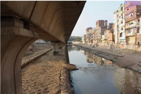
Fig 1. Nizamuddin informal area. Sebastião Santos
DELHI METROPOLITAN AREA - A REVIEW OF PLANNIG PRACTICE
The colonial city or the ‘Garden-city’ of the powerful
In its origin Delhi corresponds to a set of fortified nuclei or ‘cities’ founded by the Mughal empire of which Shahjahanabad (Old Delhi) would be the capital. It was possible to observe a social hierarchy ‘embedded’ in its physical structure: in the citadels, at the top, would live the clerics or administrators and in the outskirts, or outside the walls, in densely built areas, the remaining inhabitants7. British
occupation did not invert this trend to urban stratification; on the contrary, it deepened even more. A crucial moment in the history of Delhi was the decision to transfer the colonial capital from Calcutta to Delhi (1912), due to the partition of Bengal and the rise of nationalist attitude against the British occupation in Calcutta. It became necessary to design a new city, able to ‘perform as a political symbol’ and strategically respond to imperial interests of stabilization, a city that would be able to confirm its importance near the old capital of the Mughal empire8. ‘New Delhi’ Lutyens plan was the
first planning instrument that addressed the new capital, in what seems to be a transference of Ebenezer Howard's city-garden movement into the Indian urban context.9 In contrast to the
densely-occupied 'Old Delhi', where mixed land use coexisted with a large cultural diversity, New Delhi was planned as its opposite, a low-density city with wide avenues to accommodate car traffic, green areas to combat the extreme climate and a new urban order based on the spatial division of its social structure according to “race, occupational rank, and socio-economic status”10 11. During the 30’s, the
bipolar nature of the city becomes clear, with the imperial, comfortable and planned New Delhi on one side, and the congested and unplanned Old Delhi on the other side, where informal mixed-use occupations (dwellings, shops and small industrial units) proliferated but also diseases (tuberculosis,
malaria) leading to a high infant mortality rate12. Over Population and urban densification, coupled
with insufficient sanitation structures, end up compromising public health. In 1937, Arthur Parke Hume was nominated responsible for the first attempt to solve the accelerated city growth through the development of Delhi Improvement Trust (DIT).13 This tool should improve road infrastructure,
sanitation and waste treatment systems, but, above all, the elimination of slums by building new neighbourhoods to meet the needs of a homeless population expected to rise up to 200 000 in a fifteen year projection.14 British Central Government resisted to the idea of addressing informal areas through
the planning system by opting for an alternative scheme, based on developing new neighbourhoods for high-income classes, in order to finance housing for the poor in a later phase.15 This strategy failed to
meet its objectives, not only due to continuous delays but mainly as a consequence of succeeding events, independence and partition between India and Pakistan (1947), that leaded to a huge population influx. Urban development model under the colonial period was mainly based on the interests of the British Empire. Indian people had minimum influence in policy or decision-making across administration scales. The garden-city model based on principles of social progress and environmental concerns that emerged under a scenario of precarious working and leaving conditions in British industrial cities was appropriated and (re)contextualized into an urban model based on social segregation and the representation of colonial generating a bi-polar city, New Delhi (planned for government and administrators) and Old Delhi (not addressed by planning systems).
The modern independent metropolis or the subversive city
As the efforts for a unified India failed, extreme violence and an unprecedented migration of Sikh and Hindu refugees from Pakistan to the capital occurred. The jump from a city to a metropolis seems to have started here. Between 1941 and 1951 the population increased from 700 000 inhabitants to 1.4 million inhabitants and the area of the city doubled.16The spread of slums and informal areas was
paralleled by the lack of multiple infrastructures due to an ‘environment’ of weak regulation and control over the urban form. In response, the first Delhi Master Plan (MPD 1962) was developed from a partnership between Delhi Development Authority (DDA) and the American Ford Foundation that was already supporting the country in the process of institutional modernization and policy development.1718 MPD 1962 was influenced by the American school of planning in the 1960s in areas
such as urban regeneration, functional planning or zooning, and it also followed the trends of Indian development policies in the early decades of the independence (1950s and 1960s).19 The plan included
the development of a green belt and seven satellite towns, in order to simultaneously divert and contain urban growth by decentralizing population, housing, commerce and industries to the periphery.20 Additionally a new land police drove public acquisition of large areas required for houses
and other land uses in an attempt to match supply and demand without any private assistance.21 Very
soon the first Master Plan of Delhi became obsolete. In 1971, the growth of the city had already largely surpassed the numbers forecasted. Industries and commercial spaces had spawned and housing needs increased. Approximately 1.5 million people lived in substandard houses or in expanding slums.22The first MPD 1962 was the object of multiple criticisms: on one side, the American planning
team blamed the failure of planning with the overload of bureaucracies, jurisdictions and leadership changes, and also to what they have defined as an Indian ‘aversion to planning’; on the other side, the Indian authorities refer the ‘plan maladjustment’ to the cultural and social reality of India, its inability to respond to the speed of economic and social transformations that the metropolis was subjected to, including powerful migratory flows23.The monopoly of public control over land leaded to constraints
regarding the proper development of urban land and plan implementation, causing an inflation of urban land prices and resulting in a constant subversion of MPD.24 The expansion of informal areas,
the eviction of slums during the state of emergence (1975-77), the proliferation of unauthorized private colonies and, more recently, the expulsion of small industries due to court orders determined the absence of a specific living, economic and industrial centre, giving rise to mobility problems and urban pollution proliferation25. The second and third planning instruments proposed by the DDA in
1985 (National Capital Region Planning Board Act) and in 2001 (Master Plan 2001) were mainly acts of revision of the first MPD 1962. Modernist planning based on principles of zoning, urban regeneration and public interest over land was endorsed as a mean to materialize the capital of an Independent India. If modernist views were greatly contested in the west for its homogeneous views of society and for the risks resulting from (de)contextualization, in Delhi its translation traduced in the general failure of planning. Constraints in the proper development of urban land, maladjustments between the plan and Indian cultural reality, the displacement of the poorest communities, small industries and commerce gave rise to the subversion of the plan and to the proliferation of an unplanned city parallel to the planned city, in response to population needs.
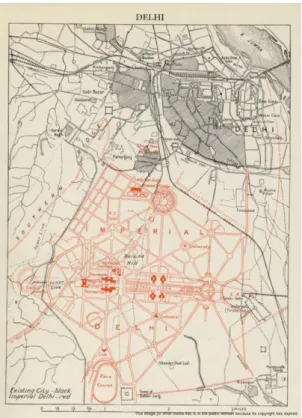
Fig 3. Delhi Master Plan 1962. Delhi Development Authority
The global megacity or the city for just a few
The shock in oil prices due to the Golf war forced the country to request for immediate help in 1990 to the International Monetary Fund (IMF). In exchange for its loan, the Indian government was obliged to make structural and macroeconomic adjustments, easing the inflow of foreign capital through a new legislation and police framework. The investment in rural areas fell from 14.5% (before the reforms) to only 6% of GDP in 1998, which together with the liberalization and mechanization of agricultural market, resulted directly in a decrease in agricultural employment and rural nutrition problems, triggering a massive migration of population from rural areas to cities in search for employment26 .
Almost simultaneously de-industrialization occurred in cities like Delhi due to the growing importance of other Asian countries. Millions of immigrants who arrive everyday in Delhi mainly integrate the low-paid informal economy (that represents around 66% of the city working force) or see their efforts to obtain a job forged, since demand is mainly increasing for graduated workers.27 The result is the
uncontrollable expanding of slums and the worsening of the already existent social inequality gap.28
As Mike Davis points out in ‘Planet of Slums’ “the Third World now contains many examples of capital-intensive countryside and labour-intensive deindustrialized cities” where urbanization “is driven by the reproduction of poverty, not by the supply of jobs”. 29 The most recent National Capital
Region Plan (NCRP 2021) and Delhi Master Plan (MPD 2021) follow the context of economic liberalization and the aim of including the metropolis in the global economic circuit. Since 1985 to 1990 police and legislation changes in India influenced by global institutions as the World Bank and IMF promoted decentralization of urban governance, stimulated multi-sectorial private public partnerships (PPP) in urban management and provided a friendly framework for business (low taxes and deregulation) in order to attract foreign direct investment (FDI).30 The spatial translation of these
changes in Delhi (National Capital Region) was the proliferation of Special Economic Zones (SEZ), business parks, massive luxurious urbanizations, shopping malls, public space revitalizations and large infrastructures (e.g. tube or highways) financed by private and public budget.31 The Asian Games of
1982 and more recently the Commonwealth Games of 2010 are also typical examples of a series of World events that triggered urban large scale investments aiming to project the city into the global network32. Also the most recent urban development program in India, “Jawaharlal Nehru National
Urban Renewal Mission” (JNNURM) constitutes a clear sign of this neoliberal planning trend. The main allocation of funding (79%) was done in the financing axes responsible for the development of large urban infrastructures (e.g. fly overs, tube, roads) on behalf of rehabilitation/rehousing processes or the development of basic infrastructures (water, sanitation and energy)33. Meanwhile the majority of
the population remains in precarious housing or without adequate infrastructure, the city is one of the most polluted in the world and environmental caring capacities, such as water provision are on the brink of collapse.34 35 Many of Delhi landscape recent transformations carried out on the name
sustainability, quality of life or environmental concerns have even contributed to the expulsion of a set of urban realities, demonstrating a clear de-articulation between social justice and environmental and economic concerns. The small industries considered polluting were relocated or eliminated from the metropolis centre leading to the loss of two million jobs. Simultaneously 3 million homes were demolished in exchange for resettlement (only for a portion of eligible families) in the city outskirts, far away from employment sources36. Instead of promoting a balanced social, environmental and
economic development, polices, financing programs and planning instruments seem to pursuit an ‘exportable urban image’ similar to those of the western global cities. In this context, Sustainability, Resilience or Smart Cities, are perceived as part of a ‘symbolic urbanism’, one that is serving mainly economic growth through the development of new urbanizations, designs and technologies for the upper and middle classes. One the other hand, a huge part of the population, have been, once again, forgotten in the plans37. A paradigmatic example of how concepts can be ill-applied is the Indian
Smart Cities program. Related to the automation of services, such as waste management and mobility, it will be implemented only in Lutyens ‘New Delhi’, the part of the city that is better served by services and that is occupied by a political an economic elite that represents only 2% of the city population.38 In what concerns participation mechanisms (introduced by 74 Indian Constitutional
Amendment) that could lead to a more inclusive city, problems have emerged: pre-defined agendas that don’t match communities ‘real problems’, participation processes that are manipulated by powerful economic players or biased by cast, gender or religion issues and, finally, the transference of public responsibilities and accountability to communities or private companies.394041
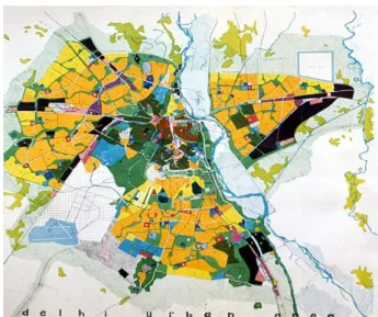
Fig 4. Delhi Master Plan 2021 Online website. Delhi Development Authority
Fig 5. Synthesis of Delhi urban transformations. Sebastião Santos, Maria de Fátima Ferreiro, Cristina Sousa