Habitat preferences, diet, feeding
strategy and social organization
of the black spider monkey
[Ateies paniscus paniscus
Linnaeus 1Z58] in Surinam
M. G. M. van Roosmalen *
" This field study of the black spider monkey was financed by the Netherlands Foundation for the Advancement of Tropical Research, The Hague. Departmental facilities were kindly provided by the Research Institute for Nature Management, the Institute of Syste-matic Botany, Utrecht, and the Agricultural University, Wageningen.
I S S N 0 0 4 4 - 5 9 6 7
ACTA
AMAZÔNICA
Número - 3/4
ABSTRACT (back cover)
HABITAT PREFERENCES, DIET, FEEDING BEHAVIOR AND SOCIAL ORGANIZATION OF THE BLACK SPIDER
MON-KEY, ATELES PANISCUS PANISCUS, IN SURINAM.
A Socioecological Field Study.
This monograph reports on a 2 6 month socioecological study of
black spider monkeys (Ateies paniscus paniscus) in the
Raleigh-vallen — Voltzberg Nature Reserve, Surinam. It recognizes the .fun-damental importance of food to the behavior and the regulation of population density fox this primate. It clarifies the complex tempo-ral and spatial effects of tropical rain forest food sources on the be-havior of a group of spider monkeys, concentrating on food category, food plant identity and phenology, and quantity, density and dis-persion of the most important food sources. In addition, the present study describes habitat choice, optimal feeding strategy and sexual behavior of the spider monkey, and discusses implications of diet for social behavior. This study is also fundamental to conservation. Specialized in eating mature fruits, the spider monkey is a very im-portant dispersal agent for many trees and lianes, particularly ca-nopy species. However, the spider monkey is probably the most vulnerable monkey species in Surinam and it is disappearing ra-pidly throughout the remainder of its range. Unfortunately, it is lar-ge and noisy and can be easily tracked and hunted. It is larlar-gely restricted to undisturbed high forest, and consequently habitat des-truction has more effect on it than on most other species. Together with its slow reproductive rate (a female gives birth only once every four or five years), this means that the species is poorly adapted to recover from exploitation. In order to implement proper measu-res for conservation, data on fomeasu-rest type preferences, diet and so-cial behavior of the species, or on closely related species, in undisturbed areas, such as the one described in this monograph, are essential tools for assessing the potential of proposed protected areas.
M.G.M. van Roosmalen (Leersum, Holland — Manaus; Brazil) Habitat Preferences, Diet, Feeding Behavior and Social
Organiza-tion of the Black Spider Monkey, Ateies paniscus paniscus, in
CONTENTS
Acknowledgements 7
1. Introduction
Background 9
Taxonomy and Distribution of Ateies 11
fbpulation Density and Biomass 12
Climate 15 Geology 16 Topography 18 Vegetation of Surinam 18
Structural Description of the Forest Types found in the
Raleighvallen-Voltzberg Region 18 Dry Evergreen Forest Types 18
Wet Forest Types 28 Xeromorphic Vegetation 30
2. Methods
The Study Area 32
Data Collection 3 7
Habituation of Spider Monkeys 37
The Synecological Part 38 The Autecological Part 40 The General Survey 44
Lolopasi, West Bank Coppename River,
Raleighvallen-Voltzberg Nature Reserve 44
Kayser Moutains 44 Other Parts of Surinam 45
3. Habitat Preferences
Preferences for Different Forest Types 46
4. Diet and Feeding Behavior
Food Categories 50 Fruits 64 Flowers 73 Leaves 74 Pseudobulbs 75 Aerial Roots 75 Bark and Decaying Wood 75
Honey 76 Insects v 76
Feeding Behavior 77 Foraging Techniques 81 Feeding Techniques 83 Feeding Heights 86 General Feeding Fbstures 86
Food Selectivity 87 Temporal Patterning of Food Choice 87
Diurnal Variation in Food Choice 89 Variation in Food Choice between Days 90 Monthly Variation in Food Choice 101 Monthly Variation in Food Supply 137 Food Supply and Food Choice. 139
Ateies as a Specialized Frugivore 140
5. Social Organization
Introduction 147 Group Size, Group Composition and Age Classes 148
Group Range and Day Range Length... 150
Grouping Behavior 151 Male Behavior 166 Calling Behavior 168 Sleeping Behavior 171 Reproductive Biology and Sexual Behavior 175
6. Conservation 179
7. Discussion 181
8. Summary 186
References 193
ACKNOWLEDGEMENTS
I am indebted to a number of people who made this study pos-sible. First of all I would very much like to express my thanks to
my friend and colleague Dr. Russell A. Mittermeier, who introduced me to the tropical rain forest and the world of Surinam monkeys. Together we set up an area for studying the synecology of Surinam monkeys, and the same study area was later used for the autecolo-gical study of spider monkeys described in this monograph. His as-sistance in the field during part of the study and his valuable discussions and critical comments, both in the field and during the analysis and writing, have been essential for my work.
Special thanks are also due to Dr. Anne van Wijngaarden, who supervised the project in all its stages, for his practical advice and encouragement and for contributing many useful comments. Without the continual support of these two people the project could never have been carried out.
I also wish to thank Prof. Dr. M.F. Mõrzer Bruyns of the Agricul-tural University, Wageningen, Prof. Dr. ES. SzalayDr. John G. Flea-gle, Dr. John F. Oates, Dr. Katharine Milton and Dr. Jan C. Dndeman for their constructive comments on the draft of this manuscript.
Thanks are also extended to Dr. A. Gentry of the Missouri Bo-tanical Garden for identifying several samples of rare Bignoniaceae;
to Mrs. Marieke E. van Roossmalen for comments on chapter 5; to Dr. Nicole Duplaix for locality data and other information on spi-der monkeys; to Dr. Jan C. Lindeman, Mrs. M. Werkhoven and Mr. P. Teunissen for valuable information on Surinam forest types and plant species; to the Surinam Geological Services for transporta-tion and lodging in the Kaiser Mountains, where I carried out a sur-vey using their trail system; to Mr. Raul Loth for assisting me in the field during the last seven months and to Mr. Frits van Troon, tree-specialist of Dienst's Lands Bosbehee, for marking about 10,000 trees and lianes in the study area.
I am greatly indebted to my Surinam Bushnegro and Amerin-dian friends and their children on Foengoe Island, Raleighvallen. They provided us, and particularly my wife and son, a very
plea-sant atmosphere in which to live during the course of the held study.
Many thanks go to Mr. Arjan Grifhoen, the artist of the Research Institute ÍOT Nature Management, Leersum, for preparation of the histograms and maps.
I shall always be much indebted to my wife Betty for the unsel-fish contribution she has made to every aspect of this long study. Moreover, most drawings of food items were made by her in the held. This field study of the black spider monkey was financed by the Netherlands Foundation for the Advancement of Tropical Research, The Hague. Departmental facilities were kindly provided by the Research Institute for Nature Management, the Institute of Syste-matic Botany, Utrecht, and the Agricultural University, Wageningen.
1. INTRODUCTION
1.1. Background
The role cá food as a basic determinant cá social organization and behavior has been a much discussed topic in the recent literature on free-ranging primates (Chivers, 1977; Clutton-Brock, 1974; Ras-mussen, 1979; Rodman, 1973, 1977; Wrangham, 1977, 1979). Un-fortunately, the detailed autecological studies on undisturbed primate populations urgently needed for this investigation are few in num-ber. One of the main reasons may be the fact that primatology and botany are a rare combination of skills. The floristic complexity of the oldest terrestrial ecosystem on earth, the tropical rain forest, su-rely plays a role as well. Recognizing this before starting the pre-sent field sdudy, I compiled all available data on fruits and seeds of woody plants of Surinam since it was known that all monkeys occu-ring in' the country are at least partly frugivorous (Husson, 1957). Two years of research resulted in a book (àurinaams Vruchtenboek,
1977) with detailed descriptions of the fruits and seeds of about 1400 species of tree and liane. In most cases a drawing was included, in addition to general descriptions of leaves and inflorescences of the species, habit of the plant and habitat preferences. This book turned out to be a useful guide for identifying most food plants in the field. Feeding monkeys drop fruit parts and sooner or later com-plete fruits, sometimes with leaves attached, whereas trees and lia-nes usually drop their fruits in a certain stage of maturity, making the collecting of fruits much easier than that of flowers and leaves.
The identification of species in the field on fresh samples in-creases one's knowledge of the forest much faster than the usual way of collecting, preserving, shipping and, much later, identif-ying the samples. Knowledge of plants is of great advantage to stu-dies of monkeys. Types and subtypes of forest are easier to recognize by determining and recognizing certain indicator species. One's un-derstanding of the forest is better when one is no longer walking in a highly variable mass of trunks and stems. By fixing in one's memory special properties of individual trees of known species, one
becomes habituated to every part of the forest previously visited. All one's attention can be directed to the monkey's behavior. Also the phenology of forest plants can easily be studied by collecting all kinds of fresh fruit from the forest floor from month to month in suc-cessive years. In this way periodicity and length of fruiting period can be determined for many species, both at individual plant and species level.
Until recently, very little information was available on diet and
habitat choice of Ateies paniscus paniscus. More is known about
two other Ateies species, A. belzebuth and A. geoffroyi.CR.
Car-penter (1935) reported on a natural population of A. geoffroyi in
Panama. He described the species as frugivorous. About 9 0 % of the items consumed were said to be fruits. Little data on other food stuffs were reported by Carpenter. In 1969, Madik and Hladik des-cribed feeding behavior, diet and guantitative and chemical analyses
of many food items used by a group of A. geoihoyi , reintroduced
to Barro Colorado Island, Canal Zone, in 1961. Since their study did not cover an entire year, it is difficult to interpret their results. Moreover, the monkeys lacked the traditionally developed knowledge of food and optimal feeding strategy as found in wild populations.
Klein and Klein observed free-ranging A. belzebuth in the
Colom-bian National Park, La Macarena, during one year (1967-1968). Among other things, they collected information on diet, feeding be-havior, feeding heights and sites and social organization (1972, 1976,
1977).
The present study recognizes the fundamental importance of food both to the behavior and the regulation of population density for the black spider monkey in Surinam. It clarifies the complex tem-poral and spatial effects of food souices on the behavior of a group of spider monkeys, concentrating on food category, food plant identity and phenology, and quantity, density and dispersion of the most important food sources. In addition, this study describes habitat choi-ce, optimal feeding strategy and sexual behavior, and discusses im-plications of diet for social behavior. This study is also fundamental
from the viewpoint of conservation. Ateies is probably the most
vul-nerable monkey species in Surinam. It is large and noisy and can be easily tracked and hunted. In undisturbed areas, it usually reacts to a human intruder by performing a 'branch shaking and branch
dropping display' which attacts other nearby subgroups. A hunter
can wipe out most of the group with little effort. Moreover, Ateies
is largely restricted to undisturbed high forest, and habitat destruc-tion has more effect on it than on most other species. Another im-portant point is its slow reproductive rate. A female usually gives birth only once every four or five years, meaning that the species recovers slowly from exploitation. In order to implement proper mea-sures for conservation, data on forest type preferences and diet of the species that are to be protected, are needed since they are es-sential tools for assessing the potential of proposed protected areas.
1.2. Taxonomy and Distribution of Ateies
The taxonomy of the genus Ateies is the subject of some
con-troversy. Kellogg and Goldman (1944) recognize four species of
Ate-ies: A. geoffroyi, A. iusciceps, A. belzebuth and A. paniscus. Several recent authors (e.g. Hershkovitz, 1972; Groves, 1972; Moynihan,
1970, 1976), however, consider all Ateies conspecific and refer to
them collectively as A. paniscus (the oldest available name).
Re-cent studies indicate that there may be some 1 - 2 chromosome sig-nificant differences among the species recognized by Kellogg and Goldman (Heltne and Kunkel, 1975). Furthermore, an important
con-tact zone between A. geoffroyi and A. iusciceps exists in eastern
Panama and the species apparently hybridizes to some extent (Rossan and Baerg, 1977). Until further information becomes available, I
prefer to follow Kellogg and Goldman (1944) and use the name
Ate-ies paniscus in the strict sense.
The Surinam representative of the genus is Ateies paniscus
pa-niscus (Linnaeus, 1758). It is found in lower Amazonia, between the Rio Negro and the Atlantic and north to the Guianas (Kellogg and
Goldman, 1944), a range similar to that of Saguinus midas midas,
Pithecia pithecia, Chiropotes satanas chiropotes and Cebus nigii-vittatus, four of the other seven primate species occuring in
Suri-nam. The second A. paniscus subspecies, A. p . chamek, is found
in western Matto Grosso, eastern Bolivia and northeastern Peru and extends into Brazil as far east as the Rio Jurua, a southern tributary of the Rio Amazonas (Kellogg and Goldman, 1944). The other three
species of Ateies are found from Southern Mexico to the southern
reaches of the Amazon basin.
In Surinam, A. p . paniscus is almost entirely restricted to the
interior. Like Chiiopotes s. chiiopotes and Cebus nigrivittatus, it just
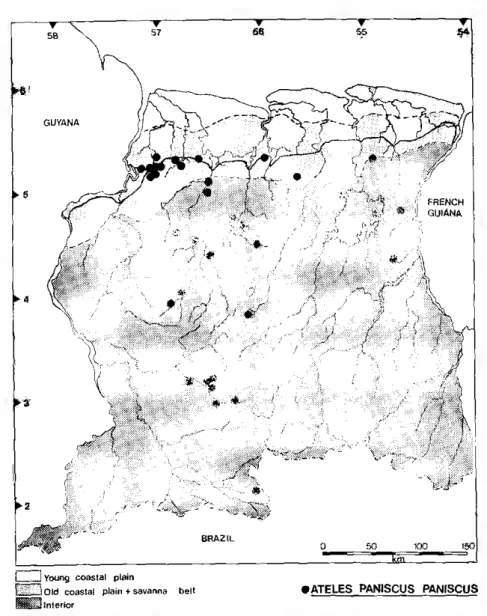
enters the old coastal plain in the western part of the country (fig. 1). Its is covered with long, glossy black hair. The naked face va-ries from light to dark pink and is sometimes lightly freckled (fig. 2). The eyes are usually brown, but some individuals have blue eyes. The female has a long pendulous, backward-directed clitoris, that immediately distinguishes her in the field. The scrotum of the male is black. The hair on the head in both sexes is long and directed forward, forming a peak over the eyes (hg. 3). Individual difference in face color and marking, eye color, hair tufts, hair length and physi-que make the animals readily recognizable in the held, even at great
distances. Ateies p . paniscus is a large monkey. Three males in the
British Museum had a meanisc head-body length of 545 mm (range: 515-580) and a mean tail length of 807 mm (range: 720-852); ten females had a mean head-body length of 540 mm (range: 490-620) and a mean tail length of 814 mm (range: 640-930) (Napier, 1976). Four females cited in Kellogg and Goldman (1944) had the follo-wing measurements: head-body length: 460, 418, 5 7 0 and 6 6 0 mm; tail lenght: 870, 920, 8 8 0 and 753 mm. Adult males usually are more heavily built, but sometimes extremely large females have been observed too. Five males weighed in Surinam had a mean body weight of 7.86 kg (range: 6.5-9.2) and seven females a mean body weight of 7.70 kg (range: 6.5-8.5) (Mittermeier, 1977).
1.3. Population Density and Biomass
Because of flexible grouping behavior in Ateies, accurate
esti-mation of group size, group composition and population density is only possible if the members of a group are recognizable as
indivi-duals. In the Voltzberg area in Surinam, A. paniscus occurs at a
density of 7.1. individuals or 6.3 independently locomoting
indivi-duals per km2. When only the area of suitable habitat is
conside-red, an economic density of 8.2, resp. 7.3 individuals per km2 results.
The figures from other areas vary considerably, but only the esti-mate of Klein and Klein (1976) is based on individually recogniza-ble animals of a natural population. Muckenhim, et al. (1975)
estimate 2.4-6.2 individuals per km2 for
A. p . paniscus in Guyana;
Heltne, et. al. (1975) give 2.0 individuals per k m2 for
A. p .
cha-mek in Bolivia; Klein and Klein (1976) give a density of 12-15
Figure 1 Distribution map lor Ateies paniscus paniscus in Surinam. The central broken line marks the border between the coastal region and the interior. The area immedia-tely to the north of this line is the old coastal plain, that to the south is the savan-na belt. The dashed lines indicate the borders oi the two areas. For the purposes of this study, the savanna belt is considered part of the interior, but it is actually a geological distinct region. Ateies occurs throughout the interior, but is rare in the savanna belt and only enters the old coastal plain in the extreme western part of the country.
Figure 2 Juvenile-1 Ateles p. paniscus from Surinam. The naked face is light pink and may be lightly freckled.
Figure 3 Adult female Ateles p. panisc12S from Surinam (Photo by R. A. Mittermeier).
viduals of one year or older per km2, and including infants 15-18
individuais per km2 for. A. belzebuth in Colombia; Bernstein, et.
al. (1976) estimate 9-14 individuais per km2 in northem Colombia;
Freese (1976) found 6-9 A. geolfroyi per km2in Costa Rica. In Gua
temala, Coelho et al. (1976) estimated 45 individuais per k:m2
and Cant (1978) 26 individuais per km2. ln Peru, Janson (1975)
estimated 24 A.p. chamek per km2.
The biomass for A. paniscus in the Voltzberg area in Surinam
is calculated using the mean body weigt h data derived from Mit
termeier (1977): 7.86 kg for males and 7.69 for females. The figu
res range between 0.4 and 0.5 kg/ha, depending on the home range
si.ze chosen (255 and 220 ha, resp.). Estimates from other areas are
as follows: 0.07 (Eisenberg and Thorington, 1973), 0.2 (Heltne et
al., 1975), 1.4-1.9 (Janson, 1975), 0.3-0.6 kg/ha (Muckenhim, et
al., 1975), 0.7 (Bernstein, et al., 1976), 1.5 (Coelho, 1976), 0.3-0.5
(Freese, 1976), 0.6-0.9 (Klein and Klein, 1976), and 1.4 k.g
/
ha(Cant. 1978}.
1.4. Climate
Surinam lies dose to the equator and has a typical tropical cli
mate. The mean annual temperature is 26.1 ºC (Lindeman and Moo
lenaar, 1959). Mean monthly temperatures vary only about 2?
during the year. A maximum is reached in September and October
and a minimurn in January and February. daily variations are grea
ter and range from 21.0-31.6°C at 1.5 m in the rain forest. Tempe
ratures at the top of the canopy are similar to those in clearings and
range from 21.0-36.0ºC Personally collected data over two years
at 1.5 m in the rain forest in the Voltzberg area show temperature
maxima in September, October and November and mínima in Ju
ne, July and January (Fig. 4).
Relative hurnidity in the rain forest is highest in the early mor
ning (95% or more), drops to about 82% during the middle of the
day and reaches 95% again at dusk. ln clearings and at the top
of the canopy the daily range is greater and hurnidity may be as
low as 40% in the middle of the day (Schulz, 1960; Hoogmoed,
1969).
Mean annual precipitation lies between 2,000 and 2,400 mm
(Lindeman and Moolenaar, 1959) and is not evenly distributed
tluoughout the year. Usually, four seasons are recognized. A long wet season, usually begiruúng in mid-April and lasting until mid July, with maximum rairúall in May or June. A long dry season be
gíns in August and lasts until mid-November, October is, in the ave rage, the driest month, but diliers only slightly from September. The period from December to April can be divided into a short wet and a short dry season that vary considerably in length and intensity.
The slnrt wet season usually runs hom Decernber to mid-January or Fe bruary, the short dry season hom February to April. ln abnormal years one of the two can be absent. ln 1976, the long dry season
lasted from August to 15 February 1977. Then, after a two-week wet period, a shorl dry season followed lasting six weeks, while the long wet season started about mid-April. Many trees dropped their leaves completely, giving a dead appearance to the mountain sa vanna forest. The long dzy season is characterired by a monthly rain fall of less than 100 mm. October is the driest month with as little as 20 mm locally (Hoogmoed, 1969). May is usually the wettest, with precipitation that may exceed 400 mm locally. During the two
years of observation in the Voltzberg area, the driest month was Sep tember with precipitation as low as 68 mm. The wettest month was May with 316 mm (fig 4).
The nights in the interior are mostly windless. Gales are rare. k elsewhere in the tropics the most violent winds are squalls. They occur during the transition periods (particularly in July and August) and may precede thunderstorrns. During such squalls it is risky to walk through the forest. Old lrees can be heard falling every where, especially during and just after heavy rairúall,and even youn ger vigorous trees may fall. This phenomenon of tree-fall is of great importance in the regeneration of primary forest.
1.5. Geology
The interior of Surinam is a part of the Guayana Shield, a for mation of Precambrian age that is composed mainly of granito diorit.as and granites. ln central Surinam, a single rernnant of the Mesoz.oic Roraima sandstones, the Tafelberg, has withstood erosion. The rocks in the interior are usually covered with deeply weathe red ferrosiallitic/fer rallitic soils that vary from loamy sand to clay. Here one finds high upland forest. On shallow soils covering lateri te caps and outcrops of unweathered gra nite, one finds more or less
xeromorphic types of vegetation (Bakker, 1957). ln some areas, such as the Voltzberg region, exposed. unweathered rock can still .be seen at the surlace. These granite-insel.bergs are mainly covered with li
chens and algae, which cause weathering with high PH-values. The Si021 dissolved under these circurnstances is deposited in the fonn of small, very resistant sheets. Together with the lichens and al gae, the Si02 - sheets shut the granite off hom deeper
weathe-J
30
20
10 \
j
> .. \
• ; ... ':�·
.. :.p� ...
F M A
\ /
O 4....;,...s ...;hor1--I -J.--,-+. season
M J J A
\
\ \
\
5 0 N
\ /
\ /
D J
mean ma>eimum temperature in
ºe
mean minimum temperalure ín
ºe
cm
Figure 4 Climate o! lhe Voltzberg study area during lhe present study, showing lhe monthly va1ialions of mean maximum and mirumum lemperahue ai 1.5 m in the rain fo. resl (full lines) and rainlall in a clearing (broken line). Data were collected from May 1976 to May 1978.
ring, a process which seems to be essential in the forming of inselbergs in the tropics (Bak.ker, 1957).
1.6. Topography
The coastal region of Surinam has almost no relief. ln the inte rior several low mountain ranges are found, the highest peak being
1,280 m (Wilhelmina Mountains). Severa! plateaus, for instance the Brownsberg (514 m), are given mountain status in Surinam, as are isolated outcroppings such as the Voltzberg (240 m) and the Van Stockumberg (360 m).
Six major rivers dissect the country and for the most part flow hom south to north. The Corantyn formes the borrier between Suri nam and Guyana, the Marowijne divides Surinam and French Guia na (fig. 5). The lower reaches of the rivers are calm, but the upper
reaches bekm 5? N are boken by many rapids (eg., the Raleighvallen complex in the Coppename River near the Voltzberg).
1. 7. Vegetation of Surinam
The Surinam coast primarily consists CÍ. mudHats covered by man
gro.-es which are hclen by occasional beaches. Behidind these lie large stretches of swamps, cut by sand and shell ridges running parallel to the coast. Moving further south, there is a belt of rain and marsh forests, then a narrow belt of white sand savannas and savanna fo rests, and finally the rain forests of the interior (Hoogmoed, 1969).
The savanna belt, which begins roughly 25 km from the coast in the east and 80 km in the west, is not part of the coastal region and can be considered a dívision of its own or part of the interior. The interior is for the most part covered with high tropical rain fo rest broken by other forest types and small savanna enclaves. The largest of these is the Sipaliwiní Savanna, which is located in the extreme south and connected with the larger Paru Savanna of Bra zil (fig. 5).
1.8. Structural Description of the Forest Types found in the
Raleighvallen-Voltzberg Region.
1.8.1. DRY EVERGREEN FOREST TYPES
Tropical Rain Forest
High rain forest. The range of forest types in Surinam covers Beard's
(1955) categories of true tropical rain forest and evergreen
nal forest. Since there is a co ntinuum betwe en the two categories, it is preferable to follow Lindeman and Moolenaar (1959) and Ri
chards (1952) in using the term high rain or high forest, dryland forest to include the two Beard types.
--- \ \
- -, '
SOkm
-Figure 5 Map o! Surinam showing the location of the Rale1ghvallen Voltzberg Nciture Rewr ve and the other eighl protected areas 1n the counlry.
High rain forest or high forest is found in areas not affected by seasonal flooding of rivers. The soil varies from loamy sand to clay, drainage is faiI to good and litter decomp::isition is good. It is usually possible to distinguish three or four storeys in high forest. The up per storey consists of emergent trees which can reach 40-50 m and occasionally higher (in Surinam only Cedrelinga cateniíorrnis rea ches 60 m). Below the emergents is the canopy, which ranges from 15-30 m and can itself be divided into three categories, the upper parl (25-30 m), the middle parl (20-25 m) and the lower part (15-20 m). The understory consists of slender trees up to about 15 m, whe reas saplings and undergrowth species make up the bottom 3 m.
ln general, the crowns of the emergent trees are more wide than deep and spread over the top of lower trees around them. No lianes connect them with the canopy crowns. The canopy crawns are al
most as wide as they are deep and are connected by many lianes, whereas those of the understory vary from long and narrow to tape
ring. Many species of liane (some important families are Bignonia ceae, Celastraceae, Convolvulaceae, Legurninosae, Menispermaceae and Moraceae) occur in high forest, but individuais of each spe cíes are usually widely dispersed. Epiphytes, including many Ara ceae and Orchidaceae, occur mainly in the crowns of trees. Stilt roots are rare, but bu�tresses are common. The herb layer is very open and consists mainly of broad-leaved forest grasses, small sa prophytes and shrubby Rubiaceae Palms are common in high fo rest. Oe•nocarpus bacaba reaches the canopy, whereas Astrocaryum, Attalea and Bactris are found in the understory (Lin deman and Mooleneaar, 1959).
High forest is very rich in species and seldom shows any ten dency to single-species dominance. The abundance of species ma kes it difficult to characterize high forest flor istically. ln the preser.t study, the floristic composition of high forest and high mountain sa vanna forest in the Voltzberg region is parlially analyzed by means of l/2 ha plots, in which about all trees and lianes representing po tential food somces for Ateles are plotted (Appendix). The most im portant vegetational attributes measwed are munber and disbibution
of the component plants. The most decisive criterion in the evalua tion of relative importance of a species in a given forest stand is the number of individuals. Success in the struggle for existence is
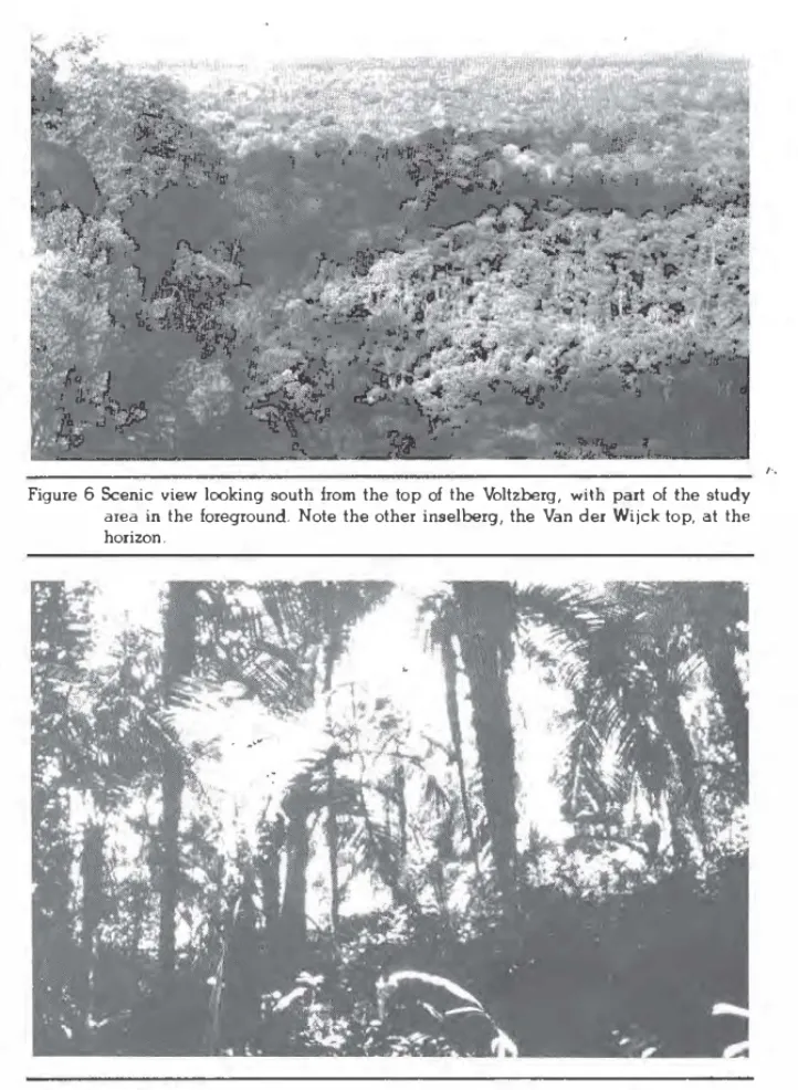
Figure 6 Scenic view looking south !rom the top of lhe Voltzberg, with part of the study ama in lhe foreground. Note the other inselberg, the Van der Wijck top, at lhe horizon.
Figure 7 Understory and shrub layer of high forest in the VOltzberg study area, locally do minated by lhe "boegroeroak<i" palro (Astrocaryum sciophilum).
Habitat ... 21
shown by reaching a reproductive state. The composition of the fo rest shows distinct variations from place to place. Some species show a wide ecological amplitude, others do not and are more local. Al
so the method of dispersa! probably plays an important role. For
example, seeds may be dispersed by wind, by water, endozoochori
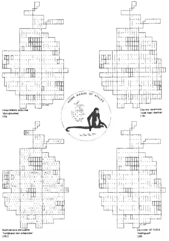
cally, exochorically by rodents or autochorically. Figure 8 shows the
distribution pattem of some species from lúgh forest following diff ferent dispersai strategies. It seems likely that species dispersed
by wind and those dispersed endozoochorically will show a random
distribution pattem (e.g.1 Vataireopsis speciosa and Clarisia race
mosa, resp.) when it is considered that the entire seed shadow under and nearby the parent plant will be destroyed by terrestrial seed predators (e.g .. bruclúd weevils and rodents) wlúch focus on these concentrations of seeds (pers. obs.). On the other hand, species dis persed by scatter-hoarding rodenls may show a clumped distribu
tion pattem (e.g., Eschweilera corrugata) since these animals do not
carry seeds far away from the parent plant for storage. Seeds that escape from predation in this way and manage to grow success
-fully will produce a non-random distribution pattem. This will also
be the case in species wlúch produce relatively small fruits contai ning many seedlets, such as berries. The seeds are mostly donnant, only genninating in a natural clearing caused by treefall. Germi
nation is induced by strongly fluctuating soil temperature (as in Ce
cropia latiloba (Holthuyzen and Boerbeem, 1982)
As demonstrated in figure 9, lúgh forest has far more species
producing edible fruit for monkeys and man than any other forest
formation. Of a total of 486 species of fruit with an edible layer re
corded for Surinam, 331 (68.1 %) are found in lúgh forest. Conse
quently, high forest is the most imporlant primate habitat in Surinam.
Ali eight primate species occur in lúgh forest and severa! (e.g., Ateies,
Cebus nigrivittatus and Chi.ropotes) are largely restricted to this for mation.
The lúgh forest of the Voltzberg region seems to offer a some what poorer appearance than the lowland rain forest in its optimal
form. ln general, the lower part of the canopy and the undergrowth
are poorer in species, perhaps due to the abundance of boegroe
maka palms (Astrocaryum sciophilum) that locally form a fairly con
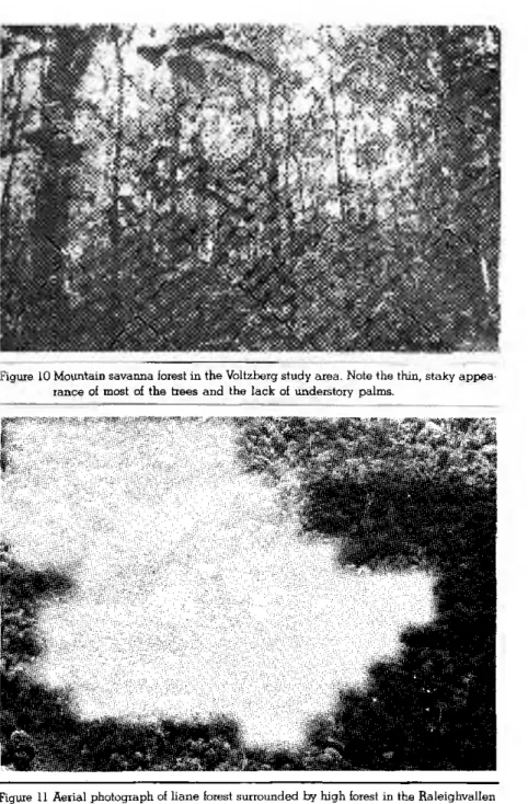
tinnuos layer at about 8 m height (fig. 7). The ground flora ic:; very
V&U•r90Pll150•icloa.t 'djon.gok•bi!I' 1701
bdlwtiltJI (OíN'jlllia
'hooglllKI oem...o.rkltk' (761)
c1.,111• , • .,,01-6
'roOI �I �lc..i1· � 191
C.(rOPM La! doba •tiio.pepe1•' t391
Figure 8 Distribution patterns of lour tree species occurring in high fores! in the Voltzberg rngion. The sampled area shown in lhe figure is pari ol the Voltzberg study .:trea and is divided into 112 ha plots. The shaded a1eas indicate open granite and liane fores!. Vafaireopsis speciasa, an emergent lree, has wind-dispetsed winged lruits;
Clarisia racemasa has nutritious lruils containing one large seed, that is disper
sed only by spider monkeys; Eschweilera corruga/a has woody operculate lruits containing severa! large edible seeds lha! are mainly ealen and stored by agoutis and acouchis, and Cecropia latiloba is a pioneer plant, growing in edge ha bitats and treefall-clearings, dispersed via dormant seeds by a number of oppor tunistic fruil-ealets including many birds.
sparse. Young acaulescent h:Jegroemalca palms locally dominate and, together with the old palms which have a well-developed trunk up to 5 m and sometimes even up to 12 m, they effectively intercept the light. High density of this palm seems to be possible because
of its dispersai by scatter-hoard.ing rodents, its extremely slow growth, and its broad fishtrap-like, heavily spined crown that catches fal ling_ leaves and continually produces a ci.Icular heap of humus around the base of the trunk.
The observer, once experienced in correctly cutting leaves off the spiny young boegroema.ka palms, could walk very easily thorough this type of high forest, an important factor in tracking fast moving monkeys as Ateles. ln addition, it makes it easy to find onés way back or to trace a route of monkeys previously followed. The silvery underaide of cut palm leaves clearly marks the trail through the forest.
Ú>w rain forest. This term is used to designate a type of high forest that does not exceed 20 m in height. It is far richer in lianes than neighboring high forest and has far fewer boegroema.ka palms. It usually forms a transition between high forest and liane forest, and sometimes between mountain savanna forest and liane forest. It isn't shown on the vegetation map (fig. 17) as it usually covera only small stri ps along the margins of other forest types.
Riverbank high forest. Riverbank high forest is absent from most of
the coastal region, but it is common in the interior. ln areas where river banks are high and not affected by seasonal flooding of ri ver margins, riverbank high forest may grow right up to the ri ver's edge. The structure of this type of forest is very similar to that of inland high forest, but the composition is clearly different.
A continuwn seems to exist; in the Raleighvallen area severa) in dicator species for riverbank high forest could be detennined, and these disappear about 700 m inland. The Voltzberg study area began almost two kilometers from the bank of the Coppename River and, therefore, this forest type was not present there.
Mountain Savanna Forest
Mountain savanna forest occurs on bauxite hills and low moun tains where only a thin layer of soil covers the underlying rock. It is similar to white sand savanna forest in xeromorphy, thin-stemmed aspect, coriaceous str ucture of leaves and lack of clear
70 681 SPECIES WITH EDIBLE FRUIT
50
o
� �
(j) (j) >
(/') w (/')
o o � lii
w
a: a: z z
s: f2 ;2 ;2 OL.LI Za:
<( <( ...J ...J ...J ...J ºº frl LL
z <( �
z z i=' (/')
§ z � ...
� (/') (/') � �
� <( w w (/') C/l
(/') (/') <( a: a: w w
w z (/') o
e a: a:
cc
� ...J LL e o
e z � (/') J: (/') e.. ::!! w LL w
J:
B a cc
� z �
t'.l <( <(
:e ::!! u ::!! C/l ::J a:
FigUie 9 Woody plant species that produce lruit with an edible layer for monl<eys and man
and, � 2 m in heighl iin bígh beet and 8EMlllal ctber beet lypee in SUiinam. Not íncluded are the lamilies Araceae and Palmae or those species that produce edi ble seeds. High lorest has lar more kinds of edible !rui! than any other lormation. Data on edibility are taken from Van Roosmalen's study on SUiinam !ruits (1977).
tion into storeys (it has a rather regular canopy of small crowns with few eme:rgents), but it differs in floristic compooition. Lianes are com mon, but not nearly as common as in fonnations such as liane fo rest. Understory palms such as boegroemaka are conspicuously absent. The undergrowth consists mainly of shrubs and treelets of the families Rubiaceae and Myr taceae, and is easy to walk t.hrough. Visibility is much better than in high forest (fig. 10).
The dominant plant families in mountain savanna forest are Myr taceae, Rubiaceae and Sapotaceae, which include several im portant fruit- prod.ucing trees for monkeys. ln total, 90 species of hee and liane producing fruit with an edible layer have been recorded hom mountain savanna forest (fig. 9).
A high mountain savanna forest fonnation, intermediate between typical mountain savanna forest and hig h rain forest, sometimes oc curs on more favorable parts of the bauxite plateaus and in granite areas such as those surrounding the Voltzberg and the Van Stoc kumberg in the upper Coppename region. Some of the dominant species in this forest fonnation are Ecclinusa gw·anensis, Guettarda
acreana, Lafoensia pacari and Pteocarpus vs. santalinoides. At ed
ges high mountain savanna forest one frequently finds important food hees for monkeys such as Ceiba pentandra, Hymenaea courbaril
and Spondias mombin.
During extremely dry seasons (e.g., 1976), which seem to oc cur inegularly at intervals of a few to many years, most of the trees hom mountain savanna forest drop their leaves, giving the forest a dead appearance. ln normal years only some of the hees seem to be deciduous.
Liane Fozest
Liane forest is a formation in areas with stony lateritic soils pro viding had rooting conditions and poor foothold for trees. It is no teworthy for the absence of storeys. Tall trees do occur, but they are so widely separated hom one another that no true canopy exists. The space between the trees is filled with dense tangles of lianes, vines and twiners that grow in abundance because of unrestricted exposure to sunlight (fig. 11). Although occasional trees in liane fo rest may reach 30 m or more, the liane tangle itself rarely exceeds 10-15 m.
A large number of species are represented in liane forest, but most of them are of very low frequency. A total of 76 species produ-cing fruit with an edible layer have been recorded from liane forest in Surinam. The dense liane tangles provide many microhabitats for insects and other arthropods, making them a fertile foraging
ground for partly insectivorous monkeys (eg., Saimiri and Cehus).
1.8.2 WET FOREST TYPES
Swamp Forest
Following Beard (1955), the term swamp forest is used for fo-rest on soil which stays wet to damp throughout the year and as a result aeration of this soil is permanently impeded. Swamp-forest soils are actually under water most of the year and, if not inunda-ted, at least remain damp during the peak of the dry season. The soil is usually composed of heavy clays and litter. The Utter decom-poses poorly because of bad aeration and accumulates to form a peat layer.
In the Raleighvallen-Voltzberg region only a single type of swamp forest is present along the small creeks and streams that flow
al-most all year round. Because of dominance of the pina palm,
Eu-terpe oleracea, which locally forms pure stands, it is called pina swamp (fig. 12). Pina swamp forest reaches at least 2 0 m in height and, because of scattered tall trees, it cannot be differentiated clearly into storeys. The irregular canopy ranges from 18-30 m and is
cha-racterized by trees such as the buttressed Virola surinamensis and
Pterocarpus officinalis, the stilt-rooted Symphonia globulifera, and
Pachira insignis and Eperua ialcata, all of which are food plants of Ateies. The most common tree is Euterpe oleracea itself, reaching
the canopy. Another palm tree, Astrocaryum sciophilum, is common,
especially in drier places. Visibility is good. The undergrowth is open, since it is formed by relatively few saplings of the above
mentio-ned species and Euterpe oleracea itself. Locally, a dense herb
la-yer can be present, which can hinder progress.
A total of 122 tree and liane species producing fruit with an edible layer have been recorded from the various kinds of swamp forest, but pina swamp forest alone is rather poor in edible species (fig. 9).
Marsh Forest (Seasonal Swamp Forest)
Marsh forest or seasonal swamp forest in Beard's (1955) termi-nology is the term used for a number of two-storey forest types who-se soils are periodically but not permanently inundated during the year. In drier parts of the year they He above the ground-water ta-ble, making aeration possible.
Marsh forest is an important habitat for several monkey species. The dense, liane-covered lower storeys along river margins pro-vide excellent foraging grounds for the partly insectivorous species
such as Saimiri sciureus. Marsh forest is rich in plant species,
inclu-ding many with seeds dispersed by wind or water. Of all tree and liane species producing fruit with an edible layer, 131 (27%) are found in marsh forest. However, the only type of marsh forest occur-ring in the Raleighvallen-Voltzberg region is riverbank marsh forest.
Riverbank marsh iorest. This type of marsh forest occurs along river
margins and is seasonally flooded by rising waters. The maripa palm,
Ãttalea regia, can be regarded as a good indicator species for all
types of marsh vegetation. This palm and several Bactris spp. can
dominate locally to create palm forests'.
1.8.3. XEROMORPHIC VEGETATION
Rocksavanna
Rocksavanna is a rare vegetation type found in the Vpltzberg region only on granite where the rock is bare or covered by shallow soil. It consists of bushes, terrestrial epiphytes, cacti and grasses. No palms occur, but some thin lianes and twiners are present. Ma-ximal height is 5 m. The vegetation is not closed. At edges of
rock-savanna areas, an important edible-fruit producing tree, Spondias
mombin, can be found (fig. 13)
Figure 13 Transition from mountain savanna iorest to rocksavanna. Important edible-fruit producing trees such as Spondias mombm and Ecchnusa guianensis can be found at edges of rocksavanna.
2. METHODS 2 1. The Study Area
The present study was conducted in the Raleighvallen-Voltzberg Nature Reserve, a protected area oi 56,000 ha that was established in 1961 and is currently managed by STINASU; the Surinam Natu-re Conservation Foundation. It is located on the east bank of the Coppename River in central Surinam (fig. 5) and is bordered on the north by the Kwama Creek and on the south by the Tanjimama Creek (fig. 14). It includes Raleighvallen, the boulder-strewn rapids and falls (fig. 15) that mark the limit of navigability of the Coppe-name River, and several granitic 'inselbergs' most notably the 2 4 0 m dome-shaped Voltzberg (fig. 16) and the Van Stockumberg. The headquarters of the Raleighvallen-Voltzberg Nature Reserve are on Foengoe Island, which is situated at the lower end of the Raleigh-vallen rapids. The island can be reached by plane or by boat. A three-hour trip by car followed by a three to five-hour trip by motorized dugout-canoe brings a visitor to Foengoe, situated about six kilometers from the Voltzberg. It has restricted facilities for tou-rists and researchers and it served as a main base during the pre-sent study.
In March 1976, together with the primatologist R.A. Mittermeier, a detailed reconnaissance was carried out and the borders of the
Voltzberg Study Area were established. With the help of several Su-rinam field assistants a grid of main trails was cut at 5 0 0 m inter-vals, for a total of 15.5 km of trail. In the 130 ha area surrounding the camp and at the edge of a large granite plate, an additional 11.2 km of side trails were cut at 100 m intervals, parallel to the long axis of the study area. The finer grid was necessary in this area because it was the most important part of the spider monkey group home range.
The study area consisted of 10 blocks of 25 ha each, two in-complete blocks limited by the Voltzberg and together covering about 44 ha, and a final section of about 12 ha extending the study area to the start of the main tourist trail ascending the Voltzberg (fig. 14). When the surface of the two large, open-granite clearings in the study area is subtracted, the total forested habitat was almost
exactly 3 0 0 ha. This study area was used during the first year for gathering synecological data on all eight Surinam primates. In the meantime, a group of spider monkeys was selected and the boun-daries of its home range determined very roughly. It soon became
Figure 14 Map showing the location of both study areas in the Raleighvallen-Voltzberg Na-ture Reserve. The trail system of the Lolopasi study area was not completed since the group of spider monkeys living in the area was too difficult to follow. No pro-gress was made in habituating them. This may have been due to light hunting pressure in the recent past. The main study area at the foot of the Voltzberg dome has only major trails at 5 0 0 m intervals indicated.
Figure 15 The 2 4 0 m Voltzberg (right in the background) and the 3 6 0 m Van Stockumberg (left in the background) seen from Raleighvallen rapids in the Coppename River about two kilometers upstream from Foengoe island.
Figure 16 Aerial photograph of the Voltzberg. The forest in the foreground is part of the study area.
evident that the original study area had to be extended approxi-mately 15 ha to the northeast and 2 5 ha to the southwest in order to cover the entire range of the group (fig. 17).
All 100 m and 5 0 0 m trails were provided with red-painted sticks at 5 0 m intervals. Each of these had aluminium tags showing
their coordinates in relation to an A-axàs directed NE and a B-axis di-rected SE from a point of origin at the western corner of the study area. After trail-cutting, a vegetation map was made by first pa-cing off vegetation boundaries along all the trails and marking them on the map. Then, each vegetation boundary was traced by com-pass and mapped. Obviously, vegetation mapping is most accura-te where the trail sysaccura-tem is most exaccura-tensive, namely in the main part of the spider monkey home range.
The forest in the study area can be divided into four ma jo, types (fig. 17). High forest predominates, followed by liane fo-rest and mountain savanna fofo-rest. Pina swamp fofo-rest grows along the small creeks that flow through the area. Low forest is present as a transitional type but hasn't been mapped, as it usually oc-curs in narrow strips along the borders of liane forest. The Voltz-berg study area has a greater diversity of forest types and edge habitats than would usually be expected in a tract of similar size in the interior. This is probably 'caused by the abundant granite out-croppings that do not provide sufficient support for most tall fo-rest trees, but do permit the growth of comparatively rare formations such as mountain savanna forest and liane forest.
Since spider monkeys never enter low forest or liane forest, the-se formations, together with open granite and rocksavanna, act as natural boundaries. As shown in figure 17, large liane forest com-plexes and the Voltzberg itself form a considerable part of the boun-daries of the spider monkey home range, giving it a peninsula-like appearance.
Other animals present. All eight primate species were well
repre-sented. Besides Ateies paniscus, one could regularly observe
Sa-guinus midas, Saimiri sciureus, Cebus apella, Cebus nigrivittatus, Chiiopotes satanas, Pithecia pithecia and Alouatta seniculus. In ad-dition to these primate species, a number of other mammals, as well
as birds and reptiles, inhabit the Voltzberg study area. Larger
ro-dents such as the agouti (Dasypiocta leporina) and the acouchi
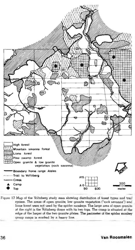
Figure 17 Map of the Voltzberg study area showing distribution of forest types and trail system. The areas of open granite, low granite vegetation ("rock savanna") and liane forest were not used by the spider monkeys. The large area of open granite at the right is the Voltzberg dome with its two tops. The camp is situated at the edge of the larger of the two granite plates. The perimeter of the spider monkey group range is marked by a heavy line.
procta exits) are cornrnom. Two kinds of squirreel' {Sciurillus pusUlus, Sciuius aestuans) and the prehensile-tailed porcupine {Coendou pre-hensilis) also occur, but are rarely seen. The carnivores are
repre-sented by one or two jaguars (Banthera onca),several ocelots(Feiis
pardalis) and a number of tayras (Eiia barbara). Edentates include
the giant armadillo, (Priodontes giganteus), the nine-banded
arma-dillo (Dasypus novemcinctus), the tamanduá {Tamanduá
longicau-data), the giant anteater (Myrmecophaga tridactyla), and two kinds
of sloth (Choloepus didactylus, Brady pus tridactylus). The common
opossum (Didelphis marsupiahs) and several smaller marsupials (eg.,
Marmosa spp.) are present. Ungulates are represented by several
collared peccaries (Tayassu tajacu) and at least one tapir (Tapirus
terrestris).
Many species of bird live in the study area and a comprehensi-ve list is gicomprehensi-ven in Mittermeier and Milton (1976) and in the field checklist of the Birds of the Guianas (Davis, 1966). The most
cons-picuous are large species such as the black curassow (Crax
alec-tor), the marail guan (Penelope marail), the gray-winged trumpeter
(Psophia crepitans) and the tinamous (Tinamus spp.). Cocks-of-the-rock (Rupicola rupicola) are surprisingly abundant. An important lek area and many nesting sites were found within and nearby the study
area. In the canopy are scarlet macaws (Ara macao), toucans
(Ram-phastos spp.), aracaris (Pteroglossus spp.) and a variety of parrots,
especially red fan parrots ((Deroptyus accipitrinus), orange-winged
parrots (Amazona amazônica) and mealy parrots (Amazona
iaríno-sa). A number of raptors, including the harpy eagle (Harpia
harpy-ja), occasionally visit the study area as well.
Frogs, lizards and snakes are common, and the turtles are
re-presented by two abundant tortoises (Geochelone carbonaria and
G. denticulata).
Insect life is varied and abundant, but mosquitos are rare. In-sect discomfort usually is caused by chiggers and a number of stin-ging and biting ants.
2.2. Data Collection
2.2.1. Habituation of spider monkeys. During the first year, when
the synecological part of the study took place, a group of spider monkeys was selected for the detailed autecological study that was
planned for the second year (May 1977 - May 1978). Since the area had been undisturbed for at least several decades, the animals we-re not particularly shy. From time to time, tourist groups walk along
the main trail to the Voltzberg thorough part of the group's range.
Therefore it is likely that each member of the Ateies group saw
peo-ple before this study began. In any case, the animals in the groups, except for one old male, no longer responded to people with the screaming - branchshaking and dropping - defecating display typical of Ateies that have had no contact with humans. They also didn't flee at the first glimpse of humans as do spider monkeys where they are hunted.
While siudyings synecology of the eight Surinam primate spe-cies during the first year, many census walks were made of the en-tire study area. Data were collected while looking for 'target' species or tracking them. During this period, many contacts were made with all members of the spider monkey study group and occasionally with members of two other groups that touched the study area. Every time spider monkeys were located, first sighting data were collec-ted for synecological purposes and the animals were followed for as long as possible. When the animals were lost, the observer retur-ned to the trail and again used the trail system to search for other monkeys. The cutting of palm leaves, saplings and lianes seemed to disturb the monkeys most, but after a while the observer got very experienced in zigzagging through the shrub layer with minimal cutting.
From February through April 1977, attemps were made to fol-low spider monkey subgroups as long as possible. After many at-tempts, and aided by the observer's growing experience in walking freely through the forest while keeping visual and especially audi-tory contact, it became possible by the beginning of April 1977 to track spider monkeys day after day without noticeably disturbing either their ranging behavior or activity patterns. Working alone see-med to be essential for this. When accompanied by one or more observers, it was hard to maintain contact and the monkeys' beha-vior seemed to be influenced significantly.
2.2.2. The synecological part. The synecological study in the
Voltzberg study area was initiated in March, 1976. Synecological data were gathered on all eight primate species for 10-15 days each
month until April, 1977. A total of 132 held days were spent stud-ying synecology only. During the first phase and later on, my col-league R.A. Mittermeier also collected data on synecology. We gathered data during 12 census walks of the entire study area, spread over a year, and while while looking for and tracking 'target' spe-cies selected for a given day. The following kinds of information were recorded every time a group was encountered: time, location in the study area, forest type, edge or non-edge habitat, activity (e.g., res-ting, traveling, feeding on plant food, foraging for or feeding on in-sects), height and level in the forest, how located (e.g., spontaneously seen, heard vocalizing, heard crashing, heard dropping fruit or fae-ces), path-animal distance and obsewer-animal distance (both for census purposes), group size and, if possible, group composition and direction of travel. All data on preferences for different forest types, vertical stratification, activity and location of the group were ba-sed on first sightings only, in order to avoid possible bias cauba-sed by the presence of the observer. When first sighted, the visible mem-bers of a subgroup were usually all engaged in the same activity,
at the same level and in the same ioiest type, especially in the case
ot spider monkeys. In order to avoid confusion, first -sighting data were based on the hist individual actually seen, which is essentially an instantaneous focal-animal sample .
A sighting was considered an edge when the first animal seen was within 2 0 m of a clearing or another forest type. Feeding on plant iood was considered the activity when the first animal seen was eating fruits, leaves, flowers or vegetable matter. Foraging for or fee-ding on insects was considered the activity when the first animal seen was eating or actively searching for insects or other animal life. For stratification, observations the forest was divided into six le-vels : shrub layer ( 0-3 m ), understory (3—15 m), lower part of the canopy (15-20 m), middle part of the canopy (20-25 m), upper part of the canopy (25-30 m), and emergents (30-60 m). It was usually im-possible to estimate the height of emergents accurately because of intervening vegetation and the limitations of the clinometer. Ho-wever, it was usually quite easy to determine whether or not a tree was an emergent simply by its relationship to surrounding trees.
Location within the study area was determined by using the markers situated at 50 intervals along the trails. Measuring the
tance from a particular tree to the nearest marker gave quite accu-rate coordinates tor each sighting.
Synecological data continued to be gathered during the second part of the field study on spider monkey autecology. At this time
Ateies became the 'target' species, and synecological data were only collected while searching for spider monkeys or when encountering other species while tracking spider monkeys.
2.2.3. The autecologieal part. The study on the autecology
of spider monkeys in a strict sense was started in the Voltzberg study area at the end of April 1977, and lasted until the beginning of May 1978. For each month of attempt this full year an attemp was made to observe spider monkeys for seven full days, but in several months only five or six days were possible. A total of 135 days was spent in the field during this period, resulting in over 8 6 5 hours of observing only spider monkeys. Usually 10-14 days had to be spent each month in the study area, divided into two sessions of 5-7 days each. As a rule, the first and the third week of each month were spent in the study area, but sometimes the second and the fourth week were chosen.
In natural habitats, spider monkeys are usually observed in small subgroups of variable size and composition. The subgroups within a group interact peacefully with one another, but groups are sepa-rated from one another by agonistic interactions, particularly bet-ween the males who appeared to act territorially and to respect quite clearcut boundaries. In order to spot a 'target' subgroup at the start of a session, several methods could be used. On returriing to the
study area after an absence of 7-10 days the situation had always drastically changed. Changes in the fruit-producing plant species and also in individual plants usually resulted in completely diffe-rent foraging routes for the monkeys. A fresh start had to be made every time. Therefore, at the start, part of trail system was covered until a subgroup was encountered. The searching could last for hours or sometimes for as much as a full day. A long call by a male spi-der monkey, which was somentimes performed in response to imi-tation calls, helped in saving time. The calling male or 'his" subgroup could then be found using a compass, or at least efforts could be concentrated on a more defined area. In case of prolonged lack of success, the Voltzberg could be climbed in the late afternoon in the
hope of seeing spider monkeys entering one of the huge, usually leafless or early flushing sleeping trees. If so, the tree was located before returriing to camp and the next day an attempt was made
to be present at the foot of this tree at 5.45 h. It was then necessary to remain continuously with the animals until evening, between 17.00 - 18.30 h, when they entered another sleeping tree. If contact with a subgroup was lost, it was necessary to return to the nearest trail and try to find this or another subgroup as soon as possible.
The following data were collected while tracking spider mon-key subgroups. At five-minute intervals the composition of the sub-group was recorded, the activity of all members of the subsub-group, and the stratum and forest type occupied. The coordinates of every trail crossing were recorded by pacing the distance to the nearest marker. When the animals were feeding complete samples (eg., in-fructescences, inflorescences, leaves and/or bark) were collected whe-never possible. Usually several visits to a particular food plant were needed, as spider monkeys generally show a very economic use of food resources. When the monkeys didn't drop a complete sample of the food plant, a collection was made as soon as possible by a native tree climber from the Surinam Forest Service. Each food plant actually used by the monkeys was marked with a numbered alumi-nium tag and a piece of red-fluorescent plastic flagging tape, nai-led on just after the monkey(s) left the tree. Using a water-resistant pencil, date and monkey species were written on the plastic tape and, later, the coordinates of the food plant were determined. Food samples were collected in plastic bags sealed by a piece of plastic tape on which time and tag number were written. Back in the Voltz-berg camp, a picture of all items eaten that day was taken with a Nikkormat EL camera, using a 52 mm macro lens. The samples were preserved by adding some formaldehyde ( 2 % sulotion) and were then labelled. Upon returning to the base camp on Foengoe Island, all samples were identified if possible, using the book on the fruits of Surinam (Van Roosmalen, 1977) and monographs of certain plant families and genera (Berg, 1975; Wessels-Boer, 1965). After making a drawing of each new food item, including cross-sections and other details, all samples were put in jars, labelled and stored.
Faeces were also collected and preserved. Spider monkey fae-ces usually consisted mainly of undisgested and unharmed seeds
and stones (seeds protected by a hard endocarp), especially during the wet seasons. Consequently, the faeces were not compact and when they fell to the forest floor the seeds dispersed over quite a wide area. If this happened, as many of the seeds and/or stones as possible were collected.
Data on phenology of trees and lianes of many species, espe-cially those used by monkeys, were gathered in the following man-ner. While searching for or tracking spider monkey subgroups, the observer visited almost every part of the groupu's range over the course of a few days. During these walks throughout the year, the presence of fresh flowers, fruits or fruit-parts on the forest floor was noted, and new species were collected and identified. In this way, timing and length of flowering and fruiting periods were determi-ned for many plants, not only on a species but also on a individual level.
In September 1977, together with a native tree specialist and an assistant, a marking program was initiated, which lasted about
seven months. By this time, almost all important food species of Ateies
had been determined, and many of them had already been collec-ted during the synecological part of the study. A list of 120 impor-tant species, including food trees, easily recognizable lianes and some sleeping trees, was compiled using vernacular names. When a species was not known to the tree specialist, samples from seve-ral individuals were shown to him so that he could learn its special properties such as type of habit, colour, taste and texture of bark and/or wood, presence of latex, type of leaves, etc. Each species was given a code number. The most important part of the spider monkey group range, approximately 2 0 5 ha, was inventoried. For this purpose, new transects were cut at 5 0 m intervals, perpendicu-lar to the 100 m trails, resulting in about 3 7 0 rectanguperpendicu-lar blocks of half a hectare each (fig. 8). All individual trees and lianes be-longing to the listed species were marked with an aluminium tag different from the kind used to mark trees which the spider mon-keys were actually seen feeding. In this way, block after block was inventoried and the location of each numbered plant was approxi-mately determined by its place in a certain half-hectare block. Trees below 12 m were not included, as this was determined to be the lower limit of the spider monkey vertical range. For the purpose of
this study, tagging and plotting was restricted to those individual plants that had obviously reached their own preferred stratum and this, in general, implies that they would flower and fruit. Plants which provided the monkeys with only edible leaves were plotted when they reached 12 m or more, regardless of whether they had reached their preferred stratum.
A total of about 10,000 trees and lianes were marked and plot-ted in special maps in order to determine their density and pattern of distribution (Appendix). In this way most of the trees and lianes, which had been marked when spider monkeys fed on them, were marked again, thus giving a double check of identification and lo-cation. Also, this provided an idea of the reliability of the tree spe-cialist, which turned out to be high.
For measurement of dietary composition, the frequency with which different foods were chosen was used. If a subgroup or a soli-tary ranging animal was seen feeding on a single food plant, one observation was scored. If a subgroup or individual moved to an-other tree of the same species, anan-other observation was scored.If a subgroup or individual moved to a different food plant species, one observation was scored for that species. If identifiable seeds or sto-nes of a given species, which had not been seen being eaten that day, were found in the faeces of a monkey, one observation was scored for that species. This method may seem to be somewhat crude, but it a gave a good estimate of the relative importance of different food plant species and families in spider monkey diet. Tins method is preferred to determining the total feeding time for each species, be-cause feeding rate can vary widely between foods. Some fruits are swallowed whole, others are woody and indehiscent and have to be opened first. Some fruits contain a lot of nutritions pulp and com-paratively small seeds or stones; others produce very little pulp or are eaten only for a minuscule aril. Measurement of the proportion of feeding time spent on different foods has also the disadvantage that analysis of faecal samples cannot be taken into account. Fae-cal samples can give much information, particularly for spider mon-keys, since the animals swallow and do not digest seeds and stones in 93.5% of all fruit-feeding observations. The method of quantifi-cation used in this study produces some bias towards foods that are eaten regularly but in small amounts, and towards plant species that
produce several edible items at the same time Both features, however, are rare in the case of spider monkeys and consequently this bias is of little importance. A relatively more important bias may be that produced towards species that grow at high densities. For example,
Virola meiinonii (Myristicaceae) can be overestimated in this me-thod because it is found locally in great abundance. When feeding on a particular tree of this species, the moi?keys will also visit nearby trees, each of which provides only a small crop of fruit. If these trees were more widely dispersed, they would probably be ignored be-cause of the small energy yield per tree.
2.3 The General Survey
Some other localities were investigated during the general sur-vey, and these added data to the distribution map the habitat table for Ateies.
2.3.1. Lolopasi, west bank Coppename River,
Raleighvallen-Voltzberg Nature Reserve. Lolopasi is located directly across the Coppename River from Foengoe Island, site of the headquar-ters of Raleighvallen-Voltzberg Nature Reserve. A trail of 2.9 km has been cut through the forest to enable visitors to reach the Moeder-vallen, largest of the Raleighvallen rapids. During the first part of this study, additional trails at 5 0 0 m intervals were cut to the west, roughly perpendicular to the riverbank and 600-1,000 m in-land (fig. 14). The trail system has not been finished, but a total of 7 km of trail were cut before the area was abandoned as a study site.
The Lolopasi area consists almost entirely of riverbank high forest and high forest, except for a narrow strip of marsh forest clo-se to the riverbank. Pina swamp forest and some liane forest are present, but no mountain savanna forest occurs.
All eight Surinam monkey species were encountered in the area,
but some of them, particularly Ateies, were very shy, probably
be-cause of recent hunting. It was impossible to keep track of spider monkeys for more than half an hour. No progress could be made in the habituation of the spider monkeys, but a rough idea of the population size and some dietary data were obtained.
2.3.2 Kayser Mountains. The Kayser Mountains are located in
the interior, in southewestem Surinam. The Surinam Geological