201
THE ROLE OF THE HYDRO-CLIMATIC CONDITIONS IN
CAUSING HIGH FLOODS IN THE SUCEVI A RIVER
CATCHMENT
HAPCIUC OANA
1, MINEA I.
1, IOSUB MARINA
1, ROMANESCU GH.
1ABSTRACT. – The role of the hydro-climatic conditions in causing high floods in the Sucevi a river catchment. Located in the north-eastern part of Romania, the Suceviţa catchment has been affected in the last decade, by the most serious known high floods in the modern period of hydrological observations. The significant amounts of rainfall (260 mm in five days in 2008 and 150 mm in four days in 2010) have led to the formation of high floods that have affected large areas of land near the river course. These torrential rainfall led to the recording of maximum flows showing an increased tendency from 214 m3/s in 2007 to 467 m3/s in 2010 (reconstituted value exceeding the probability of occurrence of 0.1%). Even if the afforestation degree, at the level of the catchment and its tributaries, in the mountainous area, is over 80%, the morphometric conditions given by the average high values of the slopes (37-55‰) and also by the circularity ratio (0,60 – 0,73) generate a fast drainage of the precipitation water to the riverbeds. At the same time, the human activity increases the impact of flooding because of the activities carried out near watercourses. Flooding associated with these high floods have highlighted the vulnerability of the communities manifested by weak capacity to absorb the effects of the phenomenon and to recover after such events. Therefore, the high floods of 2008 and 2010 have caused extensive damage to the localities situated in the Sucevița river catchment.
Keywords: floods, river catchment, hydroclimatic conditions, human activities, hydrotechnical works.
1. INTRODUCTION
The last decades have been characterized by increased frequency and intensity of extreme meteorological and hydrological events (Romanescu, 2006). There is a dependency relation between them, so that extreme hydrological events are induced and maintained by climatic ones. Therefore, high floods are being caused by the existence of torrential rainfalls which are contributing to certain flow rates that have surpassed historical thresholds.
The economic development related to the expansion of the urbanized and deforested territories have amplified the impact of the hydro-climatic phenomena in the catchments of the north-eastern part of Romania. Among the studies which
1
"Alexandru Ioan Cuza” University of Iasi, Faculty of Geography and Geology, Bd. Carol I, 20A, 700505, Iasi, Romania
202
carry out an analysis on the high flood formation in the Siret river catchment, the followings stand out: Hociung et al. (2009); Nedelcu et al. (2011); Obreja (2012); Ple oianu et al. (2007); Romanescu (2009); Romanescu et al. (2010, 2013, 2014).
Within the Suceviţa catchment were being recorded considerable amounts of rainfall which have been producing significant flows lately. In this context, the flood events of 2005, 2008 and 2010 are standing out due to their serious impact on communities, the high floods causing substantial material damages, but also human life losses.
The purpose of the present study is to carry out an analysis by means of interpreting the hydrological and climatological data on the conditions which can cause extreme events in the Suceviţa catchment related to certain conditions of the relief.
2.
STUDY AREA
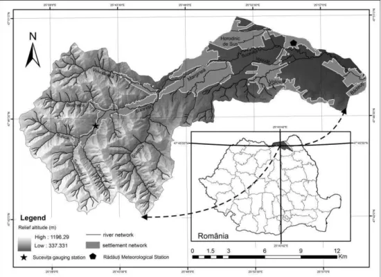
The catchment of Suceviţa river is located in the north-eastern region of Romania and it is the most important tributary of the Suceava river (Fig.1). Sucevița river flows from the altitude of 1100 m and drains an area of 199 km2.
203
The geographical position of the Suceviţa catchment has an important hydro-climatic significance through the wetter and cooler climate due to the Scandinavian-Baltic influence which has a high level of water courses fuelled by rain and melting snow in the mountain area. To the above-mentioned issues, there are added the local influence of the relief with regard to the altitude, orientation, fragmentation, presence of valleys, etc.
The Suceviţa catchment shows a high degree of forestation in the mountain area (over 80%), but since the 1990's, deforestation has been intensified. The fast drainage of the precipitation water to riverbeds is due to morphometric conditions given by the average high values of the slopes (37-55‰) and also by the circularity ratio (0,60 – 0,73).
3. DATABASE AND WORKING METHODS
In order to develop the spatio-temporal analysis of the climatic parameter values with an important role in hydrological processes, certain data have been processed and interpreted from the Sucevița hydrological station, which is the only station in the catchment, and also data throughout the Suceava catchment.
The analyzed data were provided by both Bacău - Siret Catchment Administration and Suceava Water Management System.
The database has been created for a period of 30 years, in the case of monthly data, and 10 years for daily data. The methods used are based on statistical analysis, comparison and interpretation of data, and for their exemplification were used graphics, charts and maps.
In order to achieve the digital terrain model for the Suceviţa catchment at 1:5000 scale, there were used topographical plans of which were selected the level curves, the altimetric quotas and the hydrographic network.
4. RESULT AND DISCUSSION
Hydro-climatic risks have become increasingly common due to the expansion of the built space and the increased activities near riverbeds (sawmills, gravel pits, residential constructions).
The general atmospheric circulation which stimulates and influences the pluviometric phenomenon within the studied catchment determines a rainy character with various weather phenomena. The prevailing wind direction is from the north and west with a relative frequency of 31% (at the Rădăuţi Meteorological Station) which demonstrates the general direction of the atmospheric circulation.
204
precipitation has been showing an increasing trend lately. Large amounts of rainfall, which accumulated over 260 mm in five days in 2008, and 150 mm in four days in 2010, led to serious high floods that have affected large areas of land in the riverbeds' perimeter of the adjacent localities. The maximum flow rates recorded at the Sucevița hydrographic station have increased gradually, from 95,6 m3/s (in 2003, value falling within the range of the occurrence probabilities between 2% and 5%), to 107 m3/s in 2008, and 120 m3/s (in 2010, with the probability of occurrence of 2%) (Fig. 2). Within Marginea village, located in the downstream part of the Sucevița river, the maximum flow rates have increased significantly, from 214 m3/s in 2007 to 467 m3/s in 2010 (value exceeding the probability of occurrence of 0.1%).
Fig. 2. High flood hydrographer of 2005, 2008 and 2010 in the Suceviţa catchment at the Sucevița gauging station
The occurrence of floods was due not only to the maximum recorded flow generated by a torrential rain, but also to the transport capacity of the riverbed. In the lower sector, the Suceviţa river provides an important transport of alluvial sediments which are deposited due to the slope's low rates. This leads to the decrease of the flow rate. The deposit of solid material transported by the river reduces the riverbeds' capacity and produces large increases of level causing the flooding of vast areas of land.
After these episodes with a negative impact on the communities within the Suceviţa catchment, the authorities have started certain works aimed to stop the bank erosions and increase the transport capacity of the minor riverbed within the silted areas.
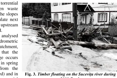
205 During torrential
rainfall, this wooden waste starts to flow down the slopes (Fig. 3) and accumulate next to the bridges, so the upstream territories are flooded.
From the analysed data of the hydrometric station of Suceviţa catchment, it can be noticed that the highest water leakage occurs in the warm season, in spring (when the water from the melting snow is added) and in summer (when the torrential
rainfall stands out). The most significant high floods which have caused serious material damages occurred in June and July.
The correlation between rainfall and flow rates was performed taking into account the monthly maximum amounts that have covered a period of 6 years (2003 - 2008) and were recorded at the Suceava hydrometric station. The analysis indicates that there is a polynomial correlation between flows and precipitation (Fig. 4) with a value of 0.75 of the r coefficient. Thus, during periods of heavy rainfall, there are also recorded the highest flow rates on the Sucevița river.
Fig. 4. Correlation between the monthly variation of the rainfall and its maximum flows in the Suceviţa river catchment (2003-2008)
206
4. 1. The high flood event from 23 to 27 of July 2008 in the Suceviţa river catchment
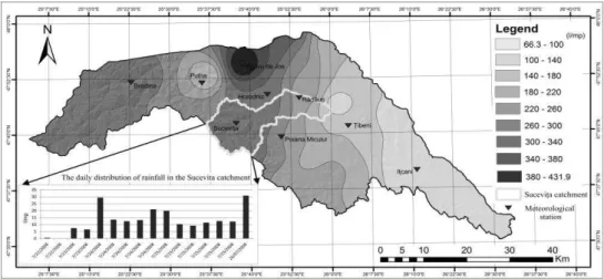
The synoptic context in which the hydro-meteorological phenomena occurred and caused high floods in the northern Moldavia has had a complex evolution. Thus, from 20 to 22 of July 2008, a front with retrograde motion has been identified over the Black Sea, then it filled with humidity and moved to the northern part of the Eastern Carpathians. Because of this front causing large amount of rainfall, high floods have occurred in the upstream of Prut and Siret rivers (Pleşoianu and Olariu, 2010). In the period 22 - 28 of July 2008, in the Suceava catchment were recorded significant amounts of precipitation which have led to unusual high floods and, throughout the same period, the historical flow rates were exceeded at several hydrometric stations. The previous period of this torrential rainfall (March - June) was characterized by pluviometric exceedance compared to the normal rates at the pluviometric stations in the Suceava catchment. This is how the level of humidity of the soil favoured a higher flow coefficient and caused the flooding of large areas of land.
By analyzing the distribution of rainfall within the Suceava catchment, it is noticed that, in only 6 days, the rainfall amounts were particularly high. The largest amount of precipitation was accumulated during 22 to 28 of July and was recorded in Vicovu de Jos with 431.9 l/m2, followed by Horodnic with 297.2 l/m2, Suceviţa with 265.8 l/m2 and Rădăuți with 202,6 l/m2 (Fig. 5). It is possible that in certain higher areas of the Suceviţa catchment or in other areas with perpendicular orientations to the forward directions of the rain front, the amount of rainfall may have been much higher, but they have not been monitored. From the analysis of the rainfall recorded in July 2008 at the Suceviţa pluviometric station, only in one day, there were 115.9 l/m2, this leading to the exceedance of the historic flow rate which has been recorded until 2008. Thus, the high floods of 2008 and 2010 have caused unusual large damages to the localities situated in the Sucevița river catchment.
207
According to the reports of flood damage finding and assessment which were made by the competent authorities in the Sucevița catchment, in July 2008 were affected 99 dwellings, of which 5 were completely destroyed and 2 were severely damaged, 3 bridges were demolished, one being located on the national road DN17A, 47 footbridges and 14 pedestrian bridges were also destroyed, 13 km of rural road and 4.95 km of the SAPARD programme for rural roads were affected. The damages' balance sheet of June 2010 carried out a number of 123 affected dwellings and annexes of which 2 destroyed and 13 having serious damages related to structure, an affected religious landmark - Suceviţa Monastery (protected by UNESCO as World Heritage), 16 destroyed bridges and 26 clogged, 11 km of affected rural and forest road. Damage was also caused to some hydrotechnical works (river bank strengthening with the help of gabions, regularization and adjustment of the Suceviţa riverbed, river bank strengthening with bottom sills, embankments).
To overcome the destructive effects of the increased water, which have occurred in 2008 and 2010 in the Suceviţa catchment, there were started and executed proper spatial planning on the affected areas, but also the arrangement of the left tributary within the Marginea village. Until 1969, the Suceviţa river has had its course only on the left tributary, but during the 1970 floods, the river has changed its course on the right tributary. The old road was opened by means of the arrangement works on the left tributary, in order to provide safety of the bridge on the national road DN17A, at the 62 + 608 Km, of the right tributary of the Suceava river. A channel with the length of 1400 m was designed on the route of the abandoned left tributary, which took half of the flow calculation (171 m3/s) and redirected the water under the second existing bridge on DN17A and located within the locality (according to the river engineering project of the Suceviţa left tributary within the area of Marginea village - Hydrotechnical systems).
5.
CONCLUSIONS
The hydro-climatic conditions related to the morphometric aspects of the small catchments can cause high floods which inundate large areas of land and produce numerous material damages, but also human losses. The maximum amount of rainfall recorded in 24h (115.9 l/m2 on the 25 of July, 2008) in the Suceviţa catchment led to catastrophic flooding. These showers are recorded on relatively small areas, but their effects are spreading forming high floods which affect the adjacent localities of the watercourse.
The human factor brings a significant contribution to increasing high floods through the deforestation of large areas, the expansion of the arable land and built space, but also through performing other activities on the watercourse.
208 Acknowledgements
This work was supported by the strategic grant POSDRU/159/1.5/S/133391, Project ”Doctoral and Post-doctoral programs of excellence for highly qualified human resources training for research in the field of Life sciences, Environment and Earth Science” cofinanced by the European Social Fund within the Sectorial Operational Programme for Human Resources Development 2007-2013.
REFERENCES
1. Hociung, C., Băi an, .A. (2009), Județul Suceava – Riscuri și vulnerabilități. Fenomene excepționale de risc. Edit. Lidana, Suceava.
2. Nedelcu G., Borcan M., Brănescu E., Petre C., Teleanu B., Preda A., Murafa R. (2011), Viituri excepționale din anii 2008 și 2010 în bazinul hidrografic Siret, Institutul Național de Hidrologie i Gospodărire a Apelor, Conferința tiințifică anuală, 1 – 3 noiembrie.
3. Obreja, F. (2012), The sediment transport of the Siret river during the Floods from 2010. Forum geografic. Studii şi cercetări de geografie şi protecţia mediului Volume XI, Issue 1, pp. 90-99 (10).
4. Ple oianu, D., Olariu, P. (2010), Câteva observații privind inundațiile produse în anul 2008 în bazinul Siretului, Analele Universității ” tefan cel Mare” Suceava, Secțiunea Geografie, Anul XIX, Suceava.
5. Ple oianu, D.M., Albu, A., Olariu, P. (2007), Aspecte privind condițiile hidroclimatice din bazinul hidrografic Siret. Tendințe de evoluție. Analele Universității ” tefan cel Mare” Suceava, Secțiunea Geografie, Anul XVI.
6. Romanescu G., Nistor I. (2010), The effects of the ul 200 catastrophic inundations in the Siret River s Lower Watershed, Romania, Natural Hazards, 57: 345 – 368.
7. Romanescu G., Stoleriu C. (2014) An inter-basin backwater overflow (the Buhai Brook and the Iezer reservoir on the Jijia river, Romania). Hydrological Processes, 28, 3118–3131.
8. Romanescu, G., Stoleriu C. (2013), Causes and effects of the catastrophic flooding on the Siret River (Romania) in July – August 2008. Natural Hazards, 63: 1351 – 1367.
9. Romanescu, Gh. (2006), Inundațiile ca factor de risc. Studiu de caz pentru viiturile Siretului din iulie 2005. Edit. Terra Nostra, Ia i.