1Instituto de Ciencias Geológicas, Facultad de Ciencias, Iguá, Montevideo, Uruguay. E-mails: [email protected], [email protected], [email protected] 2Instituto de Geociências e Ciências Exatas, Universidade Estadual Paulista, Rio Claro (SP), Brazil. E-mails: [email protected], [email protected] 3Exploración y Producción, Administración Nacional de Combustiles, Alcoholes y Portland – ANCAP, Montevideo, Uruguay. E-mails: [email protected], [email protected]
*Corresponding author.
Manuscript ID: 20170078. Received in: 06/12/2017. Approved in: 08/21/2017. ABSTRACT: he Uruguayan continental margin was generated as the result of the breakup of Gondwana and, later, the opening of the South Atlantic Ocean, which began in the Jurassic. hree major areas of Meso-Cenozoic sedimentation are located in the Uruguayan of-shore: the Punta del Este Basin, the southernmost sector of the Pelo-tas Basin and the Oriental del Plata Basin. hese basins share the clas-sical stages of tectono-sedimentary evolution of the other Atlantic basins, including the prerift (Paleozoic), rift (Jurassic-Early Creta-ceous), transition (Barremian-Aptian) and postrift (Aptian-present) phases. Based on the analysis of basin evolution through seismic sections and well data as well as on the establishment of analogies with productive Atlantic basins, four speculative petroleum systems are proposed for the Punta del Este Basin: 1) Marine petroleum sys-tem of the prerift stage: Devonian/Permian-Devonian/Permian(?), 2) Lacustrine petroleum system of the synrift stage: Neocomian-Neo-comian(?), 3) Marine petroleum system of the Cretaceous postrift: Aptian-Late Cretaceous(?), 4) Marine petroleum system of the Ceno-zoic postrift: Paleocene-Paleogene/Neogene(?).
KEYWORDS: petroleum system; tectono-stratigraphic evolution; ofshore Uruguay.
RESUMO: A margem continental uruguaia é resultado da fragmen-tação do supercontinente Gondwana e posterior abertura do Oceano Atlântico, iniciados no Jurássico. Três bacias sedimentares estão presentes na margem continental do Uruguai: a Bacia de Punta del Este, a porção mais austral da Bacia de Pelotas e a Bacia Oriental del Plata. As bacias da margem continental do Uruguai compartilham os clássicos estágios tectono-sedimentares evolutivos das demais bacias marginais atlânticas, incluindo as fases pré-rifte (Paleozoico), rifte (Jurássico-Cretáceo Infe-rior), transição (Barremiano-Aptiano) e pós-rifte (Aptiano-Presente). Quatro sistemas petrolíferos especulativos foram deinidos para a Bacia Punta del Este, baseados na análise de seções sísmicas e dados de poços e no estabelecimento de analogias com as bacias marginais atlânticas productoras de hidrocarbonetos: 1) sistema petrolífero marinho da fase pré-rifte: Devoniano/Permiano-Devoniano/Permiano(?), 2) sistema pe-trolífero lacustre da fase rifte: Neocomiano/Neocomiano(?), 3) sistema petrolífero marinho da fase pós-rifte cretácea: Aptiano-Cretáceo Supe-rior(?), 4) sistema petrolífero marinho da fase pós-rifte cenozoica: Paleo-ceno-Paleogeno/Neogeno(?).
PALAVRAS-CHAVE: sistemas petrolíferos; evolução tectono-sedi-mentar; margem continental do Uruguai.
Speculative petroleum systems of the
Punta del Este Basin (ofshore Uruguay)
Sistemas petrolíferos especulativos da
bacia de Punta del Este (ofshore Uruguai)
Ethel Morales1*, Hung Kiang Chang2, Matías Soto1, Gerardo Veroslavsky1,
Bruno Conti3, Héctor de Santa Ana3, Fernando Santos Corrêa2
INTRODUCTION
he Uruguayan continental margin is a typical volca-nic rifted margin, segmented by the Río de la Plata Transfer System (RPTS; Soto et al. 2011). hree basins are identiied: the Punta del Este Basin, the southernmost portion of the Pelotas Basin and the ill-deined Oriental del Plata Basin (Stoakes et al. 1991, Ucha et al. 2004, Soto et al. 2011, Conti et al. 2017, Morales et al. 2017) (Fig. 1).
he genesis of these basins was associated to the proces-ses that led to the fragmentation of the Gondwana super-continent and subsequent opening of the Atlantic Ocean, from the Jurassic onwards (Rabinowitz & LaBrecque 1979, Gladczenko et al. 1997, Heine et al. 2013).
Particularly, the Punta del Este Basin is separated from the Salado Basin (offshore Argentina) to the southwest through the Plata High and the Salado Fracture Zone, and from the Pelotas Basin to the northeast through the Polonio
High and the RPTS (Stoakes et al. 1991, Ucha et al. 2004, Raggio et al. 2011, Soto et al. 2011, Morales et al. 2017).
From an exploratory point of view, only two boreholes have been drilled in the Punta del Este Basin: the Lobo and Gaviotín wells (Chevron Oil Uruguay 1976). Both were declared dry wells, but it should be taken into account that they were drilled in graben shoulders in the proximal sector of the basin, in the continental shelf. Hence, they are neither representative of the basin inill (far thicker seawards) nor of the petroleum systems. In fact, the distal, still undrilled sector shows a good development of depositional systems, including marine ones, and therefore a higher petroleum potential.
GEOLOGICAL SETTING
The Western Gondwana breakup was related to the implantation of a rift system, which evolved into a passive
65°W 60° 50° 55° 45° 40° 35° 30° 25° 20°W
-7.0 -6.0 -5.0 -4.0 -3.0 -2.0 -0.5 0.0 0.2 0.4 0.5 1.0 1.5 3.5 7.0 km
20°
25º
30º
35º
40°
45°
50°
Major Fracture Zone
Minor Fracture Zone
Arch / Highs
Intracratonic Basins
Aborted riſt
Passive margin
PdE: Punta del Esse SL: Santa Lucia LM: Laguna Merín
Figure 1. Topographical–bathymetric map of South America overlain by selected ofshore and onshore basins and structural elements. Inset shows the location of the igure in relation to South America, with Uruguay
highlighted in black. Based on Moulin et al. (2005), Franke et al. (2007) and Soto et al. (2011). Sealoor topography
margin stage, either non-volcanic (northern and central segments) or volcanic (south of Santos basin; Moulin et al.
2005, Blaich et al. 2009).
In the volcanic rifted margin of the Southwestern Atlantic (ofshore of Argentina and Uruguay) a group of aborted rift structures, oriented perpendicularly to the margin, developed (San Jorge, Valdés, Rawson, Colorado, Salado and Punta del Este basins). he northernmost of these rift structures is the Punta del Este Basin (Fig. 1).
From a general point of view, four models for the gene-sis of these rift structures have been proposed:
■ the classical triple joint model as a consequence of a thermal anomaly (Introcaso & Ramos 1984, Stoakes
et al. 1991);
■ stress accommodation through rotation of the South American plate in relation to the African plate, as a result of crustal stretching north of the Walvis-Río Grande Rise and oceanic expansion to the south (Chang et al. 1992);
■ oblique extension at the beginning of Atlantic Ocean expansion (MacDonald et al. 2003); and
■ variations in strain orientation and stretching velocity (Heine et al. 2013).
All these models share the importance of the basement inheritance, the structures of which conditioned rift deve-lopment. hese structures were generated as a result of the suturing processes in Western Gondwana, which occurred at the end of the Proterozoic (Tankard et al. 1995, Pángaro & Ramos 2012, Heine et al. 2013).
Ofshore Argentina, these rift structures are bounded to the East by a conspicuous basement high, which marks the start of the Argentine Basin, placed entirely in ultradeep waters (Raggio et al. 2011, Figueroa et al. 2005, Urien 2001). his high precluded marine deposition in the Salado and Colorado basins ofshore Argentina until the Maastrichtian-Paleocene. his high becomes subtler to the NE, being almost absent in the southern portion of the continental margin of Uruguay (i.e., the Punta del Este Basin). Hence, the early postrift sedimentation in the Punta del Este Basin shows a diferent depositional architecture from the Colorado and Salado basins, which contradicts the homogeneous charac-teristics that historically have been assigned to them (Tavella & Wright 1996).
Onshore Uruguay, the Santa Lucía and Laguna Merín basins are part of a NE-trending structural lineament called Santa Lucía-Aiguá-Merín (SaLAM; Rossello
et al. 2000, 2007), which has been interpreted as an aborted rift (Veroslavsky et al. 2007). This lineament involved a first extensional stage, which started in the Jurassic, and a second dextral transcurrent stage during the Aptian-Albian.
TECTONIC AND STRATIGRAPHIC
EVOLUTION OF THE PUNTA
DEL ESTE BASIN
he tectonic and stratigraphic evolution of the Punta del Este Basin comprise four stages, each of which is characteri-zed by a particular stratigraphic architecture and structural coniguration. hese stages are:
■ prerift;
■ synrift;
■ transition; and
■ postrift (Morales 2013, Morales et al. 2017, Conti et al. 2017) (Fig. 2).
Prerift stage (Paleozoic) includes at least Permian sedi-mentary rocks (drilled by the Gaviotín well) correlated with units of the regional Paleozoic basins, which were preser-ved as relics after the general uplift and denudation caused by the Late Hercynian Orogeny (Milani & homas Filho 2000, Holz et al. 2010, Pángaro et al. 2015).
Synrift stage (Jurassic-Early Cretaceous) is characteri-zed by normal faults, either NW-SE trending in proximal sectors of the basin (initial rift stage) or E-W/NE-SW in the distal sectors (late rift phase). he inill comprises both volcanic and sedimentary rocks, as proven in the Gaviotín and Lobo wells.
Transitional stage (Barremian-Aptian) corresponds to the initial phase of thermal subsidence of the basin. It develops on a continental crust substrate and shows sag geometry, thinning towards the structural highs (Polonio and Plata highs). his stage marks the end of the tecto-nic activity of the main faults of the synrift stage. Also during this stage, graben shoulders are surpassed by the sedimentation for the irst time since the Jurassic.
METHODOLOGY
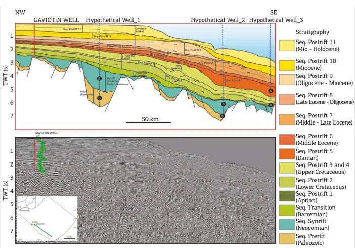
In order to perform this analysis, 2D relection seismic sections, as well as geophysical, lithological and paleontolo-gical data of the Lobo and Gaviotín wells, were used (Fig. 3). In the analysis of the seismic data, for the interpretation of depositional sequences, system tracts and the distribution of petroleum system components, the methodology com-monly used in sequence stratigraphy was utilized (for a recent review, please refer too Catuneanu 2006).
Maturation history of the potential source rocks of the Punta del Este Basin was studied through modeling of three hypothe-tical wells along a representative dip seismic line (Figs. 2 and 3). For each well, its stratigraphy was deined on the basis of the stratigraphic analysis developed by Morales et al. (2017). For each depositional sequence, the relative abundance of lithologies was estimated (Tabs. 1, 2 and 3). he referred ages correspond to the age, in Ma, of the top of each sequence.
For the speculative petroleum systems deined herein, four potential source rocks were considered: one in the pre-rift stage, one in the synpre-rift stage, and the remaining two in the postrift stage:
■ marine Permian source rock;
■ lacustrine Neocomian source rock;
■ marine Aptian source rock; and
■ marine Paleocene source rock.
he geochemical features of these potential source rocks were chosen taking into account the data published for the South Atlantic basins and the onshore basins of Uruguay (Tab. 4). In all cases, the lowest TOC value cited in the lite-rature was considered.
For thermal calibration, vitrinite reflectance values measured in the Lobo and Gaviotin Wells by Chevron Oil Uruguay (1976) were used (Tab. 5). A constant thermal lux was considered, equal to the mean global thermal lux (60 mW/m2; Pollack et al. 1993).
RESULTS
Four speculative petroleum systems (Magoon & Dow 1994) are proposed for the Punta del Este Basin:
■ marine petroleum system of the prerift stage;
1
2
3
4
5
6
7
Seq. Postriſt 11
(Mio - Holocene)
Seq. Postriſt 10
(Miocene)
Seq. Postriſt 9
(Oligocene - Miocene)
Seq. Postriſt 8
(Late Eocene - Oligocene)
Seq. Postriſt 7
(Middle - Late Eocene)
Seq. Postriſt 6
(Middle Eocene)
Seq. Postriſt 5
(Danian)
Seq. Postriſt 3 and 4
(Upper Cretaceous)
Seq. Postriſt 2
(Lower Cretaceous)
Seq. Postriſt 1
(Aptian) Seq. Transition (Barremian)
Seq. Synriſt
(Neocomian)
Seq. Preriſt
(Paleozoic)
NW SE
GAVIOTIN WELL Hypothetical Well_1 Hypothetical Well_2 Hypothetical Well_3
TWT (s)
1
2
3
4
5
6
7
TWT (s)
Stratigraphy
50 km
Figure 2. Dip seismic section (below) and interpreted geoseismic sections (above) of the Punta del Este Basin, depicting the sequences identiied in Morales et al. (2017) and the location of hypotetical wells. S in black circle:
■ lacustrine petroleum system of the synrift stage;
■ marine petroleum system of the Cretaceous postrift; and
■ marine petroleum system of the Cenozoic postrift.
Figure 4 presents the burial diagrams for the three hypothetical wells. It is considered an immature zone until Ro = 0.6%, oil zone between 0.6> Ro <1%, peak oil generation between 1> Ro <1.3%, wet and conden-sed gas zone between 1.3> Ro <2% and dry gas zone when Ro> 2%.
he speculative petroleum systems proposed herein for the Punta del Este Basin are described below.
Marine petroleum system of the prerift
stage: Devonian/Permian-Devonian/
Permian(?)
his petroleum system is related to the prerift deposits, partially drilled in the Gaviotín well, about 1,500 m thick, according to seismic data. It is apparently restricted to the proximal sector of the basin.
Source rocks are expected to be present by cor-relation with the Norte/Paraná Basin of Uruguay/ Brazil and other regional Paleozoic basins, such a s t h e He s p é r i d e s Ba s i n ( Pá n g a ro e t a l. 2 0 1 5 ) . The former basin includes Early Devonian and Early Permian source rocks with high TOC values (de Santa Ana & Ucha 1994, Campos et al. 1998, Milani & Zalán 1999, Milani et al. 2000, de Santa Ana 2000, Pángaro et al. 2015), reaching in Uruguay 3,6% (Cordobés Formation; de Santa Ana & Ucha
-30°S
-35°S
55°W 50°W
BRAZIL
URUGUAY
ARGENTINA
Uruguayan margin Wells Hypothetical Wells 2008 Seismic grid 2007 Seismic grid
100 km
Figure 3. Location of the Lobo and Gaviotín wells, 2D
seismic surveys from the database used in this contribution and locations of the hypothetical wells modelled.
Table 1. Stratigraphy and lithologies proposed for hypothetical well 1.
Sequence Age
(Ma) Age
Thickness (m)
Lithology
Sandstone Silstone Shale Igneous
Postriſt 11 0 Mio-Holocene 792 45 35 20
Postriſt 10 13 Miocene 335 20 35 45
Postriſt 9 20 Oligocene-Miocene 518 30 30 40
Postriſt 8 31 Late Eocene-Oligocene 396 20 35 45
Postriſt 7 37 Late Eocene 183 35 35 30
Postriſt 6 45 Middle Eocene 30 30 35 35
Postriſt 5 61 Paleocene 244 20 35 45
Postriſt 4 66 Upper Cretaceous 884 35 35 30
Postriſt 3 85 Upper Cretaceous 235 35 35 30
Postriſt 2 100 Lower Cretaceous 549 35 35 30
Postriſt 1 113 Aptian Not deposited
Transition 125 Barremian 1128 25 35 35 5
Synriſt 136 Neocomian 3176 45 10 35 10
Table 2. Stratigraphy and lithologies proposed for hypothetical well 2.
Sequence Age
(Ma) Age
Thickness (m)
Lithology
Sandstone Silstone Shale Igneous
Postriſt 11 0 Mio-Holocene 300 10 30 60
Postriſt 10 13 Miocene 400 45 20 35
Postriſt 9 20 Oligocene-Miocene Eroded
Postriſt 8 31 Late Eocene-Oligocene 200 10 35 55
Postriſt 7 37 Late Eocene 600 35 30 35
Postriſt 6 45 Middle Eocene 200 15 25 60
Postriſt 5 61 Paleocene 1050 15 35 50
Postriſt 4 66 Upper Cretaceous 800 45 35 20
Postriſt 3 85 Upper Cretaceous 300 30 30 40
Postriſt 2 100 Lower Cretaceous 550 35 35 30
Postriſt 1 113 Aptian Not deposited
Transition 125 Barremian Eroded
Synriſt 136 Neocomian 1700 45 10 35 10
Preriſt 251 Paleozoic 550 45 20 35
Table 3. Stratigraphy and lithologies proposed for hypothetical well 3.
Sequence Age
(Ma) Age
Thickness (m)
Lithology
Sandstone Silstone Shale Igneous
Postriſt 11 0 Mio-Holocene 335 10 30 60
Postriſt 10 13 Miocene 533 25 35 40
Postriſt 9 20 Oligocene-Miocene Eroded
Postriſt 8 31 Late Eocene-Oligocene Eroded
Postriſt 7 37 Late Eocene 877 20 35 45
Postriſt 6 45 Middle Eocene 555 20 35 45
Postriſt 5 61 Paleocene 1143 15 35 50
Postriſt 4 66 Upper Cretaceous 762 45 35 20
Postriſt 3 85 Upper Cretaceous 762 25 35 40
Postriſt 2 100 Lower Cretaceous 389 35 35 30
Postriſt 1 113 Aptian 180 10 15 75
Transition 125 Barremian Eroded
Synriſt 136 Neocomian 800 45 15 30 10
Table 4. Geochemical data for potential source rocks
used in the burial model.
Potential source rocks
Stage Age OM type TOC (%)
Preriſt Permian I 8
Synriſt Neocomian I 3
Cretaceous postriſt Aptian I 5
Cenozoic postriſt Paleocene II 1.9
Table 5. Vitrinite relectance for Lobo and Gaviotín wells (Chevron Oil Uruguay 1976).
Lobo Gaviotín
Ro (%) Depth (m) Ro (%) Depth (m)
0,25 300 0,32 650
0,4 600 0,41 1300
0,45 800 0,45 1700
0,55 1000 0,80 3300
0,7 1550 0,80 3600
0,75 1700 – –
0,85 2100 – –
1994) and 13,5% (Mangrullo Formation; de Santa Ana 2000). In particular, the latter unit comprises Type I, oil-prone kerogen.
280 240 200 160 120 80 40 0
Preriſt 132 123 120 119.5 Riſt 126 113 106 88
Preriſt 94 63 58 49
Riſt 81 57 50 35
Aptian 58 41 35 10
Paleocene 54 35 28
2.0% 0.6% 1.0% 1.3% 2.0% 0.6% 1.0% 1.3% 2.0% 0.6% 1.0% 1.3% Depth (Km) 1 2 3 4 5 6 7 Depth (Km) 1 2 3 4 5 6 7 Depth (Km) 1 2 3 4 5 6 7 Time (Ma) 280 240 200 160 120 80 40 0
Time (Ma) 280 240 200 160 120 80 40 0
Time (Ma)
Hypothetical well-1
Source rock Oil
Oil peak
Wet gas /
condensate Dry gas
Hypothetical well-2
Source rock Oil
Oil peak
Wet gas /
condensate Dry gas
Hypothetical well-3
Source rock Oil
Oil peak
Wet gas /
condensate Dry gas
Figure 4. Burial diagrams for the three hypothetical wells.
Hypothetical well-1
Source
rock Oil peakOil
Wet gas /
condensate Dry gas
Preriſt 132 123 120 119.5
Riſt 126 113 106 88
Hypothetical well-2
Source
rock Oil peakOil
Wet gas /
condensate Dry gas
Preriſt 94 63 58 49
Riſt 81 57 50 35
Hypothetical well-3
Source
rock Oil peakOil
Wet gas /
condensate Dry gas
Aptian 58 41 35 10
Reservoir rocks may include fluvio-deltaic and aeo-lian sandstones, equivalent to the Early Permian Tres Islas Formation and Late Permian Buena Vista Formation of the Norte Basin (Veroslavsky et al. 2003).
Seal rocks may be represented by Permian marine shales, as well as Mesozoic lacustrine shales and basalts of the syn-rift sequence. Traps would be mainly of structural or combi-nation type, including tilted blocks of the prerift sequence, preserved as relics bounded by unconformities.
Hydrocarbon migration would have been lateral and short vertical along prerift sandstones, and subordinately along faults in stretched crust sectors, involving prerift and synrift sequences.
Transformation of organic matter of Paleozoic source, rocks would have occurred entirely by the Cretaceous in the deepest depocenters. In shallower deposits, peak oil genera-tion would have been reached in the early Paleogene, and wet gas/condensate window, in the late Paleogene. Nowadays, this source rock is inferred to be senile.
his petroleum system has the advantage of high-quality potential source rocks, and Mesozoic-Cenozoic overburden is thick enough to ensure thermal maturation. Main disad-vantages are the low preservation potential of Paleozoic relics and the reduced porosity and permeability values expected due to the high depths reached by the reservoirs.
his speculative petroleum system is summarized in Figure 5.
Lacustrine petroleum system of the
synrift stage: Neocomian-Neocomian(?)
Rift sequence in the Punta del Este basins is represen-ted by a series of conspicuous hemigrabens, with an estima-ted thickness of up to 3,000 m according to seismic data. Although none of the hemigrabens have been drilled so far, the presence of lacustrine depositional systems with orga-nic-rich shales is expected due to geological modeling and analogies with both onshore Uruguay and basins from the South Atlantic continental margin.
Lacustrine shales with up to 10% generated the oil respon-sible for most of hydrocarbon commercial accumulations in South Atlantic basins (Mello et al. 1994, Hartwing et al. 2012, Mello et al. 2012), as well as non-commercial accumulations (e.g. AJ-1 well in Orange Basin; Jungslager 1999). Furthermore, in the Santa Lucía Basin (the onshore equivalent of the Punta del Este Basin), the lacustrine shales of the Castellanos Formation show TOC values up to 2,95% (ANCAP, 1994).
Main reservoir rocks include alluvial conglomerates and sandstones related to basin edges, lacustrine fans, and luvial and deltaic depositional systems of the synrift stage. Some of these lithologies crop out in the Santa Lucía Basin (Mígues and Cañada Solís Formations; de Santa Ana & Ucha 1994, Rossello et al. 2000). Secondary reservoirs may include shelfal sandstones and basin loor fans of the over-lying Cretaceous postrift sequence.
Seal rocks include lacustrine shales and volcanic rocks of the synrift sequence. Traps would be diverse, including stratigraphic (e.g. alluvial fans and lacustrine fans), combi-nation (e.g. truncations related to break-up unconformity, pinchouts against hemigraben shoulders) and structural traps (e.g. tilted blocks).
Hydrocarbon migration among synrift facies would have been vertical and lateral along the abundant faults of this sequence. Cretaceous postrift reservoirs may have been char-ged through longer vertical migration along reactivated faults. Transformation of organic matter of Cretaceous source rocks would have occurred entirely by the Cretaceous in the deepest depocenters. In less thick hemigrabens, oil generation peak would have been reached in the Paleocene/Eocene, and wet gas/condensate and dry gas windows by the end of the Eocene.
An advantage of this petroleum system is that it has been proven in several basins of the South Atlantic (Coward et al.
1999, Chang et al. 2008, Mello et al. 2012, Beglinger et al. 2012), and according to the geological model, its presence in the Punta del Este Basin is highly probable. However,
Devonian Carboniferous Permian Triassic Jurassic Cretaceous Paleogene Neogene
Source rocks Reservoir rocks
Seal Rocks Oberburden Formation of traps
Migration Preservation Critical Moment Marine petroleum system of the preriſt stage:
Devonian/Permian – Devonian/Permian (?) Paleozoic Mesozoic Cenozoic Geological
Time
Events of the Petroleum system
T (s)
1
2
3
4
Figure 5. The marine petroleum system of the prerit stage: Devonian/Permian-Devonian/Permian(?), showing the
chart of events and a representative seismic section. S in black circle: potential source rocks. S in blue rhombus:
reservoir depth is rather high (>3,000 m rock depth). Moreover, hemigrabens are of rather small size.
his speculative petroleum system is summarized in Figure 6.
Marine petroleum system of the Cretaceous
postrift: Aptian-Late Cretaceous (?)
Black shales formed during the Early Aptian and Aptian-Albian oceanic anoxic events (the so-called OAE1a and OAE1b, respectively; Leckie et al. 2002) are widespread in the South Atlantic continental margin (Bray et al. 1998, Davison 1999, Jungslager 1999, Van der Spuy 2003, Adekola et al. 2012, Mello
et al. 2012). hese world-class source rocks were drilled by several Deep Sea Drilling Program (DSDP) boreholes, such as DSDP 361 and DSDP 364 in Cape and Angola basins, respectively (Foresman 1978). TOC values up to 15% for DSDP 361 and 20% for DSDP 364, and kerogen types I and II, have been repor-ted for these Aptian shales (Foresman 1978, Bray et al. 1998, Hartwing et al. 2012; note that DSDP 361 and DSDP 364 were inadvertently exchanged by Bray et al. 1998 in their text).
he oldest postrift sequence of the Punta del Este Basin is dated as Aptian on the basis of its stratigraphic position and seismic attributes, very alike to those of the conjugate margin. It is the same seismic unit mapped by Grassmann
et al. (2011). he top of the unit is marked by a relec-tion equivalent to the AR2 horizon of Hinz et al. (1999). hus, black shales are expected to have been present in dis-tal positions of the continendis-tal margin of Uruguay (i.e., far from the drilled area). In fact, these shales represent the main inill of a recently recognized pull-apart basin ofshore Uruguay (Rowlands et al. 2016).
Reservoir rocks were identiied in seismic data, including Cretaceous basin loor fans, slope fans, lowstand wedges and shelf-edge deltas. Reservoir quality is expected to have improved due to pirating of ine sediments by the action of strong contour currents (Creaser et al. in press). Locally,
possible limestones atop basement highs were also identiied as secondary reservoirs. Seal rocks include regional marine shales of Paleocene-Eocene age (Gaviotín Formation).
Given the scarcity of faults in the Cretaceous postrift sequence, hydrocarbon migration is expected to have been mainly lateral, through carrier beds and unconformities.
he oil window would have been reached in the Paleocene, oil generation peak in the Eocene and wet gas/condensate in the Eocene/Oligocene. Dry gas is expected to be genera-ted since the Miocene.
his petroleum system has been proven not only in the South Atlantic’s continental margin, with both oil ields and gas ields (e.g. Kudu ield of Namibia; Bray et al. 1998). According to seismic data and geological model, its presence in the continental margin of Uruguay is highly probable. his petroleum system has the advantage of the close proximity of source and reservoir rock, which increases the probability of reservoirs to be charged. he main risk is the relatively high play depth (>2,000 m water depth and >4,000 m rock depth).
his speculative petroleum system is summarized in Figure 7.
Marine petroleum system of the Cenozoic
postrift: Paleocene-Paleogene/Neogene(?)
he shales of the Gaviotín Formation, of Paleocene-Eocene age (Daners & Guerstein 2004), were drilled by the Gaviotín and Lobo Wells and reach TOC values of up to 1,9% (Chevron Oil Uruguay 1976). However, in the region of the wells, the low overburden precluded organic matter maturation. In the distalmost sector of the continental margin, this source rock may have rea-ched the oil window.
Reservoir rocks include Paleogene and, perhaps, also Neogene sandstones corresponding to basin floor fans, lowstand wedges, and deltaic and shelfal deposits. Reservoir quality is inferred to have been improved due to pirating of ine sediments by the action of strong contour currents
Devonian Carboniferous Permian Triassic Jurassic Cretaceous Paleogene Neogene
Source rocks Reservoir rocks
Seal Rocks Oberburden Formation of traps
Migration Preservation Critical Moment
Lacustrine petroleum system of the
synriſt stage: Neocomian-Neocomian (?)
Paleozoic Mesozoic Cenozoic Geological Time
Events of the Petroleum system
T (s)
5
6
7
Figure 6. The lacustrine petroleum system of the synrit stage: Neocomian-Neocomian(?), showing the chart of
events and a representative seismic section. S in black circle: potential source rocks. S in blue rhombus: potential
(Hernández-Molina et al. in press). Regional seal rocks are represented by marine Paleogene and Neogene shales.
Traps would be of stratigraphic type. Given the absence of faults in the Cenozoic postrift sequence (fault-like featu-res are interpreted as product of shale dehydration), hydro-carbon migration is expected to have been mainly lateral, through carrier beds and unconformities.
Potential source rocks would have reached oil window in the Eocene, oil generation peak in the late Eocene and wet gas/condensate window in the Oligocene. Nowadays, dry gas is probably being generated.
his petroleum system shows a high diversity of reservoir rocks, both in age (Paleocene, middle Eocene, Oligocene, Miocene) and depositional environment (see above). Eocene barchanoid dunes, sand wave ields and sand ribbons have been recently described (Hernández-Molina et al. in press), further increasing the number of reservoir types. Reservoir may have been charged not only by the Paleocene source rock, but also potentially by Cretaceous source rocks. However, the scarcity of faults in the postrift sequence and the thi-ckness of the Cenozoic marine shales reduce the probability
of reservoirs to have been charged. Another high risk is the maturity of the source rock.
his speculative petroleum system is summarized in Figure 8.
CONCLUSIONS
As in other Atlantic passive margins, four tectono-strati-graphic stages can be identiied in the evolution of the Punta del Este Basin: prerift, rift, transition and postrift. Each of these stages shows a particular structural coniguration and stratigraphic architecture, being relatively favorable for the development of petroleum systems.
On the basis of seismostratigraphic analysis and analo-gies with other South Atlantic basins, four speculative petro-leum systems were proposed for the Punta del Este Basin:
■ marine petroleum system of the prerift stage;
■ lacustrine petroleum system of the synrift stage;
■ marine petroleum system of the Cretaceous postrift; and
■ marine petroleum system of the Cenozoic postrift.
Devonian Carboniferous Permian Triassic Jurassic Cretaceous Paleogene Neogene
Source rocks Reservoir rocks
Seal Rocks Oberburden Formation of traps
Migration Preservation Critical Moment
Marine petroleum system of the
Cretaceous postriſt stage: Aptian-Late Cretaceous (?)
Paleozoic Mesozoic Cenozoic Geological Time
Events of the Petroleum system
T (s)
6
7
8
Figure 7. Marine petroleum system of the Cretaceous postrit: Aptian-Late Cretaceous(?), showing the chart of
events and a representative seismic section. S in black circle: potential source rocks. S in blue rhombus: potential
seal rocks. R in yellow square: potential reservoir rocks. Seismic proile courtesy of ANCAP.
Figure 8. Marine petroleum system of the Cenozoic postrit: Paleocene-Paleogene/Neogene(?), showing the chart of
events and a representative seismic section. S in black circle: potential source rocks. S in blue rhombus: potential
seal rocks. R in yellow square: potential reservoir rocks. Seismic proile courtesy of ANCAP.
Devonian Carboniferous Permian Triassic Jurassic Cretaceous Paleogene Neogene
Source rocks Reservoir rocks
Seal Rocks Oberburden Formation of traps
Migration Preservation Critical Moment
Marine petroleum system of the Cretaceous
postriſt stage: Paleocene-Paleogene/Neogene
Paleozoic Mesozoic Cenozoic Geological Time
Events of the Petroleum system
T (s) 1
2
3
Overall, the third petroleum system seems to have the lar-gest hydrocarbon potential, due to the simultaneous occurrence of a potential, world-class marine Aptian source rock (proven in the South Atlantic and with lacustrine correlates onshore
Uruguay), widespread marine turbiditic sandstones close to the source rocks (favoring their charge), and a thick regional seal. Neither burial depth nor timing is identiied as risks for this petroleum system.
Adekola S.A., Akinlua A., Mangelsdorf K. 2012. Organic geochemical evaluation of Cretaceous shale samples from the Orange Basin, South Africa. Applied Geochemistry, 27(8): 1633-1642.
Becker J.J., Sandwell D.T., Smith W.H.F., Braud J., Binder B., Depner J., Fabre D., Factor J., Ingalls S., Kim S-H., Ladner R., Marks K., Nelson S., Pharaoh A., Trimmer R., Von Rosenberg J., Wallace G., Weatherall P. 2009. Global bathymetry and elevation data at 30 arc seconds resolution: SRTM30_PLUS. Marine Geodesy, 32(4):355-371.
Beglinger S.E., Doust H., Cloetingh S. 2012. Relating petroleum system and play development to basin evolution: Brazilian South Atlantic Margin. Petroleum Geoscience, 18:315-336.
Blaich O.A., Faleide J.I., Tsikalas F., Franke D., León E. 2009. Crustal-scale architecture and segmentation of the Argentine margin and
its conjugate of South Africa. Geophysical Journal International,
178(1):85-105.
Bray R., Lawrence S., Swart R. 1998. Source rock, maturity data
indicate potential of Namibia. Oil and Gas Journal. 96(32):84-89.
Campos L., Milani E., Toledo M., Queiroz R., Catto A., Selke S. 1998. Barra Bonita: a primeira acumulação comercial de hidrocarboneto
da Bacia do Paraná (Barra Bonita: The irst commercial hidrocarbon
accumulation of Paraná Basin). Brazilian Petroleum Institute - IBP. In:
Presentantion paper in Rio & Gas Conference. Rio de Janeiro, Brazil.
Catuneanu O. 2006. Principles of Sequence Stratigraphy. Amsterdam, Elsevier Science Ltd., 375 p.
Chang H.K., Assine M.L., Corrêa F.S., Tinen J.S., Vidal A.C., Koike L. 2008. Sistemas petrolíferos e modelos de acumulação de hidrocarbonetos na Bacia de Santos. Revista Brasileira de Geociências, 38(2-Suplemento):29-46.
Chang H.K., Kowsmann R.O., Figueiredo A.M.F., Bender A.A. 1992.
Tectonics and stratigraphy of the East Brazil Rit system: An
overview. Tectonophysics, 213:97-138.
Chevron Oil Uruguay. 1976. Biostratigraphy of the Lobo and Gaviotín
Wells – Ofshore Uruguay. Resumo. 1p. Internal report.
Conti B., Perinotto J.A.J., Veroslavsky G., Castillo M.G., de Santa Ana H., Soto M., Morales E. 2017. Speculative petroleum systems of the southern
Pelotas Basin, ofshore Uruguay. Marine and Petroleum Geology, 83:1-25.
Coward M.P., Purdy E.G. Ries A.C., Smith D.G. 1999. The distribution of the petroleum reserves in basins of the South Atlantic margin. In: Cameron M.R., Bate R.H., Clure V.S. (eds) The oil and gas habitats of the South Atlantic. Geological Society, London, Special Publications, 153:101-131.
Creaser A., Hernández-Molina F. J., Badalini G., Thompson P., Walker R., Soto M., Conti B. in press. A late Cretaceous mixed (down- and along-slope) depositional system on the Uruguayan Margin:
Sedimentary and palaeoceanographic signiicance. Marine Geology.
Daners G. & Guerstein G.R. 2004. Dinolagelados del
Maastrichtienese-Paleogeno en la Formación Gaviotín, cuenca Punta del Este. In:
Veroslavsky G., Ubilla M., Martínez S. (eds.) Cuencas sedimentarias de Uruguay; Geología, Paleontología y Recursos Naturales, Cenozoico. Edición: División Relaciones y Actividades Culturales de Facultad de Ciencias, Montevideo. p. 37-62.
Davison I. 1999. Tectonics and hydrocarbon distribution along the Brazilian South Atlantic margin. In: Cameron M.R., Bate R.H., Clure V.S. (eds) The oil and gas habitats of the South Atlantic. Geological Society, London, Special Publications, 153:133-151.
de Santa Ana H.. 2000. Formación Mangrullo (Cuenca Norte, Uruguay) - estratigrafía y recursos minerales asociados. Revista de la Sociedad Uruguaya de Geología, 7:2-14.
de Santa Ana, H., & Ucha, N. 1994. Exploratory potential of the Uruguayan sedimentary basins. ANCAP. Internal report. 155p.
Figueroa D., Marshall P., Prayitno W. 2005. Cuencas atlánticas de aguas profundas: principales plays. In: Chebli G., Cortiñas J., Spalletti L., Legarreta L., Vallejo E. (eds.) Frontera Exploratoria de la Argentina.
In: VI Congreso de Exploración y Desarrollo de Hidrocarburos. Mar del Plata, Argentina, p. 325-335.
Foresman J. 1978. Organic Geochemistry DSDP LEG 40, Continental Rise of Southwest Africa. Available at: http://www.deepseadrilling. org/40 [cited at Oct. 2017].
Franke D., Neben S., Ladage S., Schreckenberger B., Hinz K. 2007. Margin segmentation and volcano-tectonic architecture along the volcanic margin
of Argentina/Uruguay, South Atlantic. Marine Geology, 244(1-4):46-67.
Gladczenko T.P., Hinz K., Eldholm O., Meyer H., Neben S., Skogseid J. 1997. South Atlantic volcanic margins. Journal of the Geological Society, 154:465-470.
Grassmann S., Franke D., Neben S., Schnabel M., Damm V. 2011. Maturity modelling of the deepwater continental margin,
ofshore Argentina. Zeitschrit der Deutschen Gesellschat für Geowissenschaten, 162(1):79-89.
Hartwing A., di Primio R., Anka Z., Horsield B. 2012. Source rock
characteristics and compositional kinetic models of Cretaceous
organic rich black shales ofshore southwestern Africa. Organic Geochemistry, 51:17-34.
Heine C., Zoethout J., Müller R.D. 2013. Kinematics of the South
Atlantic rit. Solid Earth, 4:215-253.
Hernández-Molina F. J., Campbell S., Badalini G., Thompson P., Walker R., Soto M., Conti B., Creaser A., Preu B., Thieblemont A., Hyslop L., Morales E. in press. Large bedforms on contourite terraces: sedimentary and conceptual implications. Marine Geology.
Hinz K., Neben S., Schreckenberger B., Roeser H.A., Block M., Gonçalvez de Souza K., Meyer H. 1999. The Argentine continental margin north of 48°S: Sedimentary successions, volcanic activity during breakup. Marine and Petroleum Geology, 16(1):1-25.
Holz M., Kalkreuth W., Rolim S.B.A. 2010. Extension of the Paraná
Basin to ofshore Brazil: Implications for coalbed methane
evaluation. Marine and Petroleum Geology, 27:1119-1132.
Introcaso & Ramos. 1984. La cuenca del Salado: un modelo de evolución aulacogénica. In: IX Congreso Geológico Argentino y III Congreso de Exploración de Hidrocarburos. Buenos Aires, Argentina.
Jungslager E.H.A. 1999. Petroleum habitats of the South Atlantic margin. In: Cameron N. R., Bate R. H., Clure V. S. (eds) The Oil and Gas Habitats of the South Atlantic. Geological Society of London, Special Publications, 153:153-168.
Leckie R.M., Bralower T.J., Cashman R. 2002. Oceanic anoxic events and plankton evolution: Biotic response to tectonic forcing during the mid-Cretaceous. Paleoceanography, 17(3). doi: 10.1029/2001PA000623.
MacDonald D., Gomez-Perez I., Franzese J., Spalletti L., Lawver L., Gahagan L., Dalziel I., Thomas C., Trewin N., Hole M., Paton D. 2003. Mesozoic break-up of SW Gondwana: Implications for regional hydrocarbon potential of the southern South Atlantic. Marine Petroleum Geology, 20(3-4):287-308.
Magoon L. & Dow W. 1994. The Petroleum System. In: Magoon L. & Dow W. (eds.) The petroleum system – from source to trap. Chapter 1, p. 3-24. AAPG Memoir 60.
Mello M.R., Azambuja Filho N.C., Bender A.A., Barbanti S.M., Mohriak W., Schmitt P., Jesus C.L.C. 2012. The Namibian and Brazilian southern South Atlantic petroleum systems: are they comparable analogues? Geological Society, London, Special Publications, 369. doi: 10.1144/SP369.18.
Mello M.R., Mohriak W., Koutsoukos E.A.M., Bacoccoli G. 1994. Selected petroleum system in Brazil. In: Magoon L.B. & Dow W.G. (eds) The Petroleum System – from Source to Trap. American Association of Petroleum Geologists Memoirs, 60:499-512.
Milani E.J, Brandão J.A.S.L., Zalán P.V., Gamboa L.A.P. 2000. Petróleo na margem continental brasileira: Geologia, exploração, resultados e perspectivas. Revista Brasileira de Geofísica, 18(3):352-396.
Milani E.J., Thomaz Filho A. 2000. Sedimentary Basins of South America. In: Cordani U.G., Milani E.J., ThomazFilho A., Campos D.A. Tectonic Evolution of South America. Edição Especial do 31st International Geological Congress, p. 389-449.
Milani E.J. & Zalán P.V. 1999. An outline of the geology and petroleum systems of the Paleozoic interior basins of South America. Episodes,
22(3):199-205.
Morales E. 2013. Evolução tectônica e estratigráica das bacias da
margem continental do Uruguai. PhD Thesis, Universidade Estadual Paulista Júlio de Mesquita Filho, Campus Rio Claro.
Morales E., Chang H. K., Soto M., Corrêa F.S., Veroslavsky G., de Santa Ana H., Conti B., Daners G. 2017. Tectonic and stratigraphic evolution of the Punta del Este and Pelotas basins
(ofshore Uruguay). Petroleum Geoscience, 23(3). doi: 10.1144/ petgeo2016-059.
Moulin M., Aslanian D., Olivet J-L., Contrucci I., Matias L., Géli L., Klingelhoefer F., Nouzé H., Réhault J., Unternehr P. 2005. Geological constraints on the evolution of the Angolan margin based on
relection and refraction seismic data (ZaïAngo Project). Geophysical Journal International, 162(3):793-810.
Pángaro F. & Ramos V.A. 2012. Paleozoic crustal blocks of onshore
and ofshore central Argentina: New pieces of the southwestern
Gondwana collage and their role in the accretion of Patagonia and the evolution of Mesozoic south Atlantic sedimentary basins.
Marine and Petroleum Geology, 37(1):162-183.
Pángaro F., Ramos V.A., Pazos P.J. 2015. The Hesperides basin: A continental-scale upper Palaeozoic to Triassic basin in southern Gondwana. Basin Research. 28(5):685-711. doi: 10.1111/bre.12126.
Pollack H.N., Hurter S.J., Johnson J.R. 1993 Heat low from the Earth’s
interior: Analysis of the global data set. Reviews of Geophysics,
31(3):267-280. doi: 10.1029/93RG01249.
Rabinowitz P.D. & LaBrecque J. 1979. The Mesozoic South Atlantic Ocean and evolution of its continental margins. Journal of Geophysical Research, 84(B11):5973-6002.
Raggio F., Gerster R., Welsink H. 2011. Cuencas del Salado y Punta del Este. In: VIII Congreso de Exploración y Desarrollo de Hidrocarburos. Simposio Cuencas Argentinas: visión actual. Mar del Plata. Argentina. CD-ROM.
Rossello E., de Santa Ana H., Veroslavsky G. 2000. El lineamiento Santa Lucía-Aiguá-Merín (Uruguay): un corredor tectónico extensivo y transcurrente dextral precursor de la apertura Atlántica. Revista Brasileira de Geociências, 30(4):749-756.
Rossello E.A., Veroslavsky G., Masquelin H., Santa Ana H. 2007. El corredor tectónico juro-cretácico Santa Lucía-Aiguá-Merín (Uruguay): evidencias cinemática transcurrentes dextrales y controles preexistentes. Revista de la Asociación Geológica Argentina. 62(1):92-104.
Rowlands H.J., Paton D., Turner J.P., Thompson P. 2016. The
Inluence of Basement Structure and Volcanics on the Evolution
of the Uruguayan Margin. Abstract 2099767: Bulletin American Association of Petroleum Geologists In: AAPG Annual Convention and Exhibition, Denver, CO.
Soto M., Morales E., Veroslavsky G., Santa Ana H., Ucha N., Rodríguez P. 2011. The continental margin of Uruguay: Crustal architecture and segmentation. Marine and Petroleum Geology, 28(9):1676-1689.
Stoakes F.A., Campbell C.V., Cass R., Ucha N. 1991. Seismic
stratigraphic analysis of the Punta del Este Basin, ofshore Uruguay,
South America. Bulletin American Association of Petroleum Geologists, 75(2):219-240.
Tankard A.J., Uliana M.A., Welsink H.J., Ramos V.A., Turic M., Franca A.B., Milani E.J., De Brito Neves B.B., Eyles N., Skarmeta J., Santa Ana H., Wiens F., Ciribian M., Lopez P.O., Germs G.J.B., De UIT M.J., Machacha T., Miller R. McG. 1995. Structural and tectonic contros of basin evolution in southwestern Gondwana during the Phenerozoic. In: Tankard A.J., Suárez Soruco R., Welsink H.J. (eds.) Petroleum basins of South America.
American Association of Petroleum Geologists, 62:5-52.
Tavella G.F. & Wright C.G. 1996. Cuenca del Salado. In: Ramos V.A. & Turic M.A. (eds) Geología y Recursos Naturales de la Plataforma Continental Argentina., 6:95-116.
Ucha N., de Santa Ana H., Veroslavsky G. 2004. La Cuenca Punta del Este: geología y potencial hidrocarburífero. p. 173-192. In:
Veroslavsky G., Ubilla M., Martínez S. (eds.) Cuencas Sedimentarias de Uruguay: Geología, Paleontología y recursos naturales – Mesozoico. DIRAC, Montevideo.
Urien C.M. 2001. Present and future petroleum provinces of southern South America. p. 373-402. In: Downey M.W., Threet J.C., Morgan W.A. (eds.) Petroleum Provinces of the Twenty-First Century.
American Association of Petroleum Geologists. Memoir 74.
Van der Spuy D. 2003. Aptian source rocks in some South African Cretaceous basins. In: Arthur T.J., MacGregor D.S., Cameron N.R. (eds) Petroleum Geology of Africa: new themes and developing technologies. Geological Society of London Special Publications, 207:185-202.
Veroslavsky G., Daners G., de Santa Ana H. 2003. Rocas sedimentarias pérmicas de la plataforma continental uruguaya:
el prerit de la Cuenca de Punta del Este. Sociedade Geológica de España, 34:203-206.
Veroslavsky G., Rossello E.A., Muzio R., de Santa Ana H. 2007. Tectónica y magamatismo de la Cuenca Laguna Merin: relictos de una proto dorsal oceánica jurocretácica. In: V Congreso Uruguayo de Geología. Montevideo. Resúmenes. CD-ROM.