Received: December 2, 2016; Published: February 25, 2017 and Architecture Research
Monitoring the Assessment of Vernacular Buildings
using an ICT Method
Ana Virtudes1,2, Daniela Barroso2, Filipa Almeida1, João Quaresma2, Manuela Fernandes2, Sofia Conde2 and Tiago Mateus2
1. C-MADE, Center of Materials and Building Technologies, University of Beira Interior, Covilhã, Portugal 2. Department of Civil Engineering and Architecture, University of Beira Interior, Covilhã, Portugal Corresponding author: Ana Virtudes (virtudes@ubi.pt)
Abstract: Nowadays, one of the main challenges in high levels of education, is to deal with ICT as a tool in teaching methodologies.
This article aims to present some results of the use of an ICT platform as a tool in spatial analysis. It is focused on the study of vernacular architecture buildings, based on the case study of wooden house villages of Tagus river banks, in Portugal. This is the unique legacy in this country, of wooden vernacular architecture in areas submitted to regular floods. The main typology of these buildings refers to stilt-houses, which have their roots in the middle XIX century. Along the time, they have been subjected to a degradation process caused by the lack of repair actions, driving to an aggravation of their status of conservation, or caused by repair actions, driving to an aggravation of their distance to the vernacular architectural matrix. Consequently, there are less than one hundred buildings remaining in five villages. The used ICT tool refers to the software DECMAvi, which is an evaluation method of buildings, designed on purposes to analyse two criteria of these territories of vernacular architecture; the status of buildings conservation and their level of proximity to the vernacular architectural matrix. This method was tested firstly in 2014 and then in 2016, and the results are allowing to obtain results coming from a comparative analysis during this period of time, in order to know if the buildings are better, worst or in same condition, and from a spatial analysis in between the considered villages and their vernacular buildings.
Key words: ICT, spatial analysis, vernacular architectural territories, evaluation method of buildings, software DECMAvi.
Nomenclature:
ICT Information and communication technologies HCR Home condition report
ITE Technical inspection of buildings UK United Kingdom
1. Introduction
The wooden stilt-houses as a typology of vernacular architecture used by fishing communities have been threatened by the vulnerability to status of their buildings conservation, driving to their degradation. Several factors are among the causes that contribute to this decline, including the absence of spatial planning policies or building preservation guidelines in order to
preserve them. This problem is not an exception in Portugal, where the few remaining vernacular wooden stilt-houses have been neglected, leading to decay of their architectural condition, with the disappearance or abandonment of almost all buildings. This legacy is disappearing rapidly, weakening the European cultural map.
In this sense, this research presents the analyses of results from a smart evaluation method, using an ICT platform, designed for the spatial analysis of the features of wooden stilt-house villages, taking into consideration the status of buildings conservation and their proximity to vernacular matrix.
of an ongoing revolution requiring the need for specific software and expertise in order to produce multiple impacts on society, whether in general or in these particular cases of sensitive territories, exposed to continuing floods in the winter time. The study includes about 90 buildings, located along Tagus river banks, in between 50 and 90 kilometres’ distance upstream of Lisbon.
2. Existent Methods for Buildings Evaluation
Even though the scholars have been focused on the study of vernacular architecture, with examples all over the world [1-7], including in Portugal [8-11], a review of current literature has revealed the lack of methods for this typology of buildings evaluation. The existing evaluation methods for status of buildings conservation, used in several European countries, such as in the UK, Spain, France, the Netherlands or Portugal, don’t fit in vernacular architecture. They are focused on conventional buildings, thus not designed for the features of wooden stilt-houses.
2.1 The Home Condition Report Used in the UK
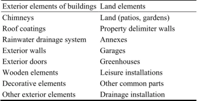
The Home Condition Report (HCR) from 2004 [12, 13] describes the status of conservation of the buildings, the main anomalies affecting the constructive elements and the situations of risk to the safety and health of users. It incorporates, among other things, the following parts: conditions for the realization of the inspection and classification of the building (type, occupation, year of construction, number of rooms, area, constructive description, installations and annexes); records of the anomalies, classification of the elements and the needs for immediate intervention; and conditions of the patio and the annexes. The evaluation model is based on a visual inspection and organized according to the following constructive elements: exterior, interior, installations and terrain. Exterior elements are considered, among other aspects, such as the coatings, the openings and their frames, the rainwater drainage system, the annexes or the garages (Table 1).
Table 1 HCR: exterior constructive elements.
Exterior elements of buildings Land elements Chimneys Land (patios, gardens) Roof coatings Property delimiter walls Rainwater drainage system Annexes
Exterior walls Garages Exterior doors Greenhouses Wooden elements Leisure installations Decorative elements Other common parts Other exterior elements Drainage installation
The application tools of this method are the Business and the Technical Standards. The first clarifies the requirements to be met by the HCR and the second, clarifies the inspection procedures and the information to be collected, giving a list of the most common problems, a template of the report, and a computer system for the issuing and registration of HCR. The evaluation criteria for the exterior, interior and installations are the need for repair or replacement, the severity of the anomaly and the urgency of the intervention (Table 2).
The land is not classified. The final result of the degradation levels is given to each element and a general appreciation of the building.
2.2 The Dutch Norm
The Dutch norm (NEN 2767) from 2006 [14] allows, through the evaluation of the conservation status of a building or group of buildings, planning the interventions, supervision of the evolution of the degradation and comparison of the results between buildings. This evaluation model is based on a visual inspection to identify the constructive characteristics and qualifies the anomalies of its elements, arranged as architecture, technical equipment, air conditioning and transport equipment.
Table 2 HCR: evaluation criteria levels.
1 2 3
The element does not need repair, subject only to routine maintenance
The element needs
repair or
replacement but the intervention is not urgent The detected anomalies are serious and/or requiring urgent intervention
The architectural elements group includes structure, walls coatings and finishes, roof, stairs and ramps, foundations, frames and the surrounding environment (land, buildings, fences and flooring) (Table 3).
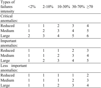
The application tools of this method are a list of the constructive elements and another of the most common anomalies, classified and prioritized according to: the importance, considering how they affect the performance of the elements; the intensity i.e. degree of degradation process development; and the extent of the affected area (Table 4).
The status of each element conservation is classified on a six-point scale. The final result is expressed in the Conservation Coefficient, which aggregates the results obtained by the elements, taking account the replacement/repair costs. The possibility of determining partial conservation coefficients for each element, allows the definition of local intervention strategies in a group of the buildings.
Table 3 NEN 2767: Architectural elements.
Architectural constructive elements
Structures and foundations Exterior and interior frames Exterior walls Exterior and interior frames Interior walls Floor coatings, stairs and ramps Floors, stairs and ramps Ceiling coatings
Roof (structure) Surface finishes
Roof (coating) Land, buildings, fences and flooring
Table 4 NEN 2767: Scores of constructive elements.
Types of failures intensity <2% 2-10% 10-30% 30-70% ≥70 Critical anomalies: Reduced 1 1 2 3 4 Medium 1 2 3 4 5 Large 2 3 4 5 6 Important anomalies: Reduced 1 1 1 2 3 Medium 1 1 2 3 4 Large 1 2 3 4 5 Less important anomalies: Reduced 1 1 1 1 2 Medium 1 1 1 2 3 Large 1 1 2 3 4
2.3 The French Assessment Grid for Habitat Degradation
The assessment grid for habitat degradation (Grille d’évaluation de la dégradation de l’habitat) from 2011 [15] aims to evaluate the housing degradation level using a grid that allows the planning of visual inspection and the systematization of the information that has to be collected. The evaluation model includes a general description of the house (including the address, year of construction, habitable surface area, number of rooms and floors) and the list of elements to make an evaluation where the performance of each in the various criteria and the respective scores are recorded.
The application tool is the methodological guide that describes the grid content and the classification system. The evaluation criteria of each element are: the state, a value for the most degraded part and the type of intervention needed; the amplitude (in percentage) of the anomaly; the proportion (in terms of quantity of elements) and the number of rooms/floors affected. Each element receives a note of degradation that results from the product between the scores obtained in the various criteria. The final result is a Degradation Indicator (including slight, medium or deep rehabilitation) that represents the distance between the higher level of degradation.
2.4 The Technical Inspection of Buildings Used in Spain
The technical inspection of buildings (ITE-inspeccióntécnica de edificios) from 2011, used in Spain is applied to buildings more than 50 years old.
This evaluation model is based on the visual inspection of the anomalies and definition of the repair measures. The exteriors of the building walls and roofs are evaluated. The walls and the roof are evaluated regarding the building exterior.
The application tools are the following: The instructions, with information about the report’s
completion; and the inspection report for information register (building characterization, anomalies and their causes, results and commitment for the execution of works).
The computer application “InformeITE” provides a predefined template of the report and a database of the anomalies (Table 5). These are evaluated according to the criterion of prejudice to the safety and structural/non-structural stability. The final result classifies the building in one of four categories depending on the anomaly classification, from which the inspection will have a Favourable result (without disabilities or with slight disabilities) or Unfavourable (serious or very serious disabilities).
In Portugal, there are as well models to assess the status of buildings conservation, based on visual inspection, classifying the levels of anomalies of the constructive elements [16-18]. However, such as in the case of the other referred European examples. In summary, the development of a suitable method for spatial analysis of vernacular wooden stilt-house territories, which was tested during the period of time of two years, is a pioneer approach. This approach allows to make the description of the evolution of these buildings during this period, in order to know if they are better, worse or in the same condition in terms of conservation.
3. ICT in Spatial Analysis
3.1 As a Key Tool for Innovation and Decision-Making
The importance of ICT in spatial analysis is based on the “capacity for innovation” and it is part of the collective decision-making system in the European cities. Many cities are performing spatial planning roles quite different from what they were just a short
time ago with the growth of high-tech, including in the domains of information and communication. Despite the information and communication technologies becoming permanent features of spatial analysis, the implications for the public realm of the use of these technologies will therefore vary due to different contexts and countries. So, there are still challenges ahead in spatial planning domain [19] such as in the field of the territorial analysis, using ICT.
The information technology revolution requiring the need for specific hardware, software and expertise) is producing multiple impacts on society in general. At the European scale, it is clear that the evolution of Europe is closely linked to the collection and analysis of data [20].
Has a decision-making tool in spatial analysis in particularly, it has enhanced methods of analysis and communication with maps and other types of spatial data. Consequently, and according to the same author, the importance of computer technologies (CT) for both quantitative and qualitative analysis has been recognised by the actors of spatial analysis and urban design i.e. city leaders (local government decision makers), planners (academics and practitioners) and association representatives, has an information tool for instance in urban economic development and in the well-being of citizens. However, this issue is novel in spatial planning and there is still a lack of research projects working about the availability and role of information (spatial and a-spatial) and the importance of spatial analysis for the well-being of society, the economy and the environment, using new technologies. CT requires digital data to display, analyse and simulate phenomena and proposes scenarios and allows collection data available to the
Table 5 ITE: Buildings classification levels.
1 2 3 4 5
No detected anomalies
Anomalies don’t affect constructive safety not put at risk outdoor elements as facades, roofs or structural elements
Anomalies may affect the safety but there is the need for further testing to check the intervention needs
Anomalies affect constructive safety but don’t require urgent repairs
Anomalies affect constructive safety and require urgent repairs
user. In this sense the use of ICT, according to the same author, goes beyond pure research and provides innovative solutions to today’s problems.
The mote of spatial analysis and IT is in the basis of a set of “dialogues” (still to be discussed) about the following subjects: the importance of channelling information from the local authority to the citizen and the dualism public and private funding, and local policy agendas for spatial analysis. In certain academic domains, such as in the fields of spatial planning, civil engineering or architecture, the use of ICT tools is a way of enhancing methods of analysis and communication, providing maps, tables and other types of spatial data. These data will support the decision-making process in educational research in particular [21].
New practices, new urban lifestyles and new locational issues for hi-tech production activities have thus emerged. Therefore, this research project aims to show the results on using ICT on spatial analysis, having as case studies the vernacular architecture territories of Tagus river banks. The goal would be to evaluate the status of buildings conservation and their proximity to the architectural vernacular matrix, through the application of the software DECMAvi.
3.2 The Design Process of the Software DECMAvi
The design process of the software DECMAvi results in the development of an ICT platform, creating a computing program for evaluation of the status of wooden stilt-houses conservation, as application tool of the developed evaluation method. This computing program is a database, which makes all the calculations automatically, showing as results the following two aspects: the outlook of each wooden stilt-house considering its status of building conservation, and the needs for immediate intervention.
The needs for immediate intervention in the building is the result of very serious anomalies that are putting in danger the safety of people or that have no
safety guaranties of building use conditions. The selection is based on two warning indicators at the same time on the same building.
The tables and the graphics, showing the statistical analysis allow establishing connections comparing buildings and comparing villages.
The final result of the status of buildings conservation is converted into a scale of five qualitative levels [22, 23]: [0-30[ for very bad condition; [30-50[ for bad condition; [50-70[ for average condition; [70-90[ for good condition; and [90-100] for very good condition. These intervals were defined based on an experimental application of the diagnosis record to a sample of buildings, allowing to test, to improve and to validate them.
The final result of the proximity of the building to the vernacular architectural matrix is converted into a scale of three qualitative levels; [0-50[ for low proximity; [50-90[ for proximity; and [90-100] for the building in the matrix. Such as in the case of the status of buildings conservation, these intervals were as well defined based on an experimental application of the diagnosis record to a sample of buildings, allowing their validation.
The initial page of the software allows to open or to create the following data: Diagnosis projects giving them a name; localization coordinates with an interactive Google map, description plan of the village; and list of buildings of each project, giving them the Diagnosis Record and the Identification Photograph.
The diagnosis record of each building, was created at the visual inspection record, allowing the introduction of the following data [24]: Identification; Photographs, until four units with a maximum of 60 Kb; Localization map, in JPEG format, with a maximum of 100 Kb; General description; Constructive description (Structure, Roof, Exterior walls, Stairs/ramp, Gallery, Terrace, Spans, Chimney and Gutters), where if an element is signed as non-applicable, the data introduction relates to it is abrogated, in the following separators; Status of
Conservation each elemen Anomaly Ind The partia Global Reco Analysis), in need for im Indexes and t conservation configuration comparative defining strat at the urban s Finally, in Bar of Initia analyses in th graphs, allow them. This an Statistics Ana In sum, th the data of e This data is there are the immediate conservation; vernacular m results are ga to support the the Global An
4. DECMA
4.1 The Verna The vernac is remaining (Caneiras, Pa along to the T They have century, in community co the Atlantic conditions on n, Record of th nt and auto dex in each grol and the glo ord (availabl ncluding the mmediate int the percentag indicators. Th n, is useful analysis in b tegies and int settlement sca
the Global A al Page) the he several villa wing the comp nalysis consid alysis and the n
is process sta each building transferred to warning indi intervention; ; and proxi matrix. Finally athered in the e Statistics An nalysis in betw
Avi Applicat
acular Village cular architec g in Portuga atacão de Ci Tagus river ba e their roots a migratory oming from th sea. During n the sea were vhe anomalies omatic calcu oup. obal results ar le in the o activated ind tervention; th e resulted fro his record, wh for each vi between build tervention pri ale. Analysis (avail results from ages are put in parative analy ders the interv number of bui arts with the i g in the Diag o the Single icators: warni ; status imity to the y, the partial Global Reco nalysis, for ea ween them.
tion and Re
es of Tagus Riv cture of wood al in five ima, Lezirão, anks (Fig. 1). in the middl movement, he central westhe winter tim very difficult, levels given t lation of th re put into th option Proje dicators of th he Anomalie m the status o hich has a tab
illage for th dings, allowin iorities locally lable in Menu both previou n a table and i ysis in betwee vals used in th ildings of them introduction o gnosis Record Record wher ing of need fo of building e architectur
and the glob rd, which aim ach village an
esults
ver den stilt-house small village , and Palhota le of the XIX of a fishin st coast, near t me the fishin and therefore to he he ct he es of le he ng y, us us in en he m. of d. re or gs al al ms nd es es a) X ng to ng e, Fig. 1 banks, u this co order activiti In t barrack such a materia the boa of thes with th there a wooden 4.2 The The the ab archite The fir in 2016 From 2014 buildin rehabil Vernacular ar upstream to Li ommunity star to get its ies [25]. the beginnin ks using the as wood or ca als, spending ats. In the de se villages alo he decline of are only five r n stilt-houses e First Evalua software DE bove referred ctural territor rst evaluation 6. m the ICT pl [27], it is ngs (28% of th litation action rchitectural vill isbon, Portugal rted to come s incomes ng, they star materials ava anes, to store the majority o cade of 1950 ong to the Ta f the fishing emaining whi [26]. ation of the Ve ECMAvi was five village ry along to th was done in latform applic possible to he 32 houses) ns, due to theirlages along Tag . to the river b from the rted to build ailable on tha e the fishing of their days li there were a agus river. H activities, no ich totals less
ernacular Buil tested two ti es of the ve he Tagus river 2014 and the cation in Can conclude th , were requiri r level of deg gus river banks in fishing d small at place, activity iving on about 80 However, wadays, than 90 ldings imes, in rnacular r banks. e second neiras in hat nine ing deep radation
(“very bad condition” or “bad condition” level in terms of conservation status) corresponding to seven wooden stilt-houses.
This model shows in the village of Escaroupim that in 2014 27% of the buildings were requiring deep rehabilitation actions, due to their degradation. In this village, there are no buildings in the “very bad condition” level in terms of the status of conservation.
Regarding the village of Palhota in 2014, five buildings (25% of a total corresponding to 20 houses), were requiring deep rehabilitation actions, due to their degradation. In this village, none of the buildings is in the “very good condition” level in terms of status of buildings conservation.
In the village of Lezirão, with six wooden stilt-houses, this model shows that in 2014, none of these buildings were needing immediate intervention, since they have no warning indicators activated. On the contrary to the other villages, previously analysed, none of this village buildings were neither in “very bad condition” level nor in “bad condition” level, in terms of status of conservation.
Finally, at the village of Patacão de Cima, with 16 wooden stilt-houses, this model shows that 13 of its buildings, all of which are empty since the decade of 1990, are requiring deep rehabilitation actions, due to their degradation, being in the “very bad condition” level or in the “bad condition” level in terms of status of conservation.
With the first application of the software DECMAvi in 2014, regarding the status of wooden stilt-houses conservation, according to a comparative analysis in between the 89 buildings of the five villages, considered as a whole, is possible to conclude that, at the time, there were no buildings in the “very good condition” level. On one hand, two thirds of the buildings were in the “average condition” level or in the “good condition” level. On the other hand, the houses belonging to the “average condition” level represented 39% of the total, considering the five villages as a whole. Above this percentage was the
village of Lezirão, where 67% of the houses were in the “average condition” level. Thus, the results showed that the village where the buildings were in the best condition level was Lezirão, followed by Escaroupim (with 60%) and Caneiras (with 41%). Below this percentage was the village of Palhota (with 35%) and Patacão de Cima (with 12%). The latter was the urban settlement where the wooden stilt-houses were in the worst status of conservation.
At the time, 27% of the 89-wooden stilt-houses were in the “good condition” level. Above this percentage was the villages of Palhota, where 40% of the buildings were in “good condition” level, Caneiras with 37% and Lezirão with 33%. Below this percentage were the villages of Escaroupim, where there was 13% of the houses in “good condition” level and Patacão de Cima where none of the 16 buildings were classified by DECMAvi model in this level. None of the 89 analysed buildings were in the “very good level” in terms of status of conservation.
Finally, one third of the wooden stilt-houses were degraded. From these, 24% were in “bad condition” level and 10% were in “very bad condition” level in terms of status of buildings conservation. Above this percentage was Patacão de Cima, which was the most degraded urban settlement, where 88% of the buildings were distributed by the “very bad condition” and the “bad condition” levels.
4.3 The Re-Evaluation of the Vernacular Buildings
The second application of DECMAvi software in 2016 to the same buildings and villages, allowed to have a comparative analysis during this period of time of two years, in order to describe the evolution of these buildings.
The results show that, for example at the village of Palhota, 60% of the traditional houses kept their levels in re-evaluation in 2016, in terms of status of conservation, when compared with the results from 2014. Here, there is only one building which has
improved its in terms of average”. Patacão de number (93. status of con 73.4%, Lezirã In the re-e time among good” level One of them Escaroupim ( In terms o vernacular application o that Palhota indicator. Ab away from Caneiras wit with 14% an this condition
5. Conclusi
5.1 Final Con The use of teaching met advantages, s On one h exhaustive su will be a g strategies an enhance this other hand, th wooden build conservation, rehabilitation be done whe and regional of all build (defined for e needs and expcondition, pa status of con e Cima is th 8%) of build nservation, fol ão with 66.6% valuation of 2 all villages, s in terms of t m is in Caneir (Fig. 2). of the proxim architectural of the softwar is the wors bout 44% of i the architect th 23%, Lezi nd Patacão de n.
ions
nsiderations f software too hodology in such as the list hand, this IC urvey of thes guideline for nd instrument vernacular a his software c dings, in ord , and there n actions. The ether regardin spatial policie ings and vil each village a pectations of l assing from t nservation to he village wh dings have w llowed by Es %, and Caneira 2016, there ar some building their status of ras and two o mity of the bu l matrix, re DECMAvi st village in its buildings a tural matrix, rão with 17% e Cima with n ols such as D spatial analys ted below: CT platform se wooden st spatial plan ts in order t architectural l can be used i der to check fore to def se rehabilitati ng the conten es (considerin llages), or lo and its buildin local communthe level “bad the level “o here a greate worsened the scaroupim wit as with 62%. re, for the fir gs in the “ver f conservation of them are i uildings to th the secon in 2016 reve terms of th are the farthe , followed b %, Escaroupim no buildings i
DECMAvi as sis, has sever results are a tilt-houses an nning policie to protect an legacy. On th n other simila their status o fine the be ion actions ca nts of nation ng an overview ocal strategie ngs) due to th nities. d” on er eir th rst ry n. in he nd ls his st by m in a al an nd es, nd he ar of est an al w es he Fig. 2 in the architec 5.2 Rec As f to deve intuitiv used e goals transfe by pub feature definiti Fina resulted vernacu Conseq this lo cultura
Refer
[1] L. Tw Ta Un [2] P. Ve Un [3] A. Ar Po Village of Esc best status of ctural matrix. commendation future researc elop skills in o ve, friendly an asily, and to of each use rred to the bu blicor private es of vernac ion of strategi ally, the applid in a deep ular stilt-hous quently, this ocal legacy, u al map of Euro
rences
Asquith, M. V wenty-First Cen aylor & Francis nited States, 200 Oliver, Built ernacular Arch nited Kingdom, . Bahamón, A. rchitecture to ortugal, 2009. (in caroupim (Por conservation ns h, there is the order to impro nd mobile ICT insert data in er. This ICT usiness domain e sectors, incular buildin ies and guidel
cation of the p knowledge se territories o knowledge is unique in Por ope. Vellinga, Vernac ntury: Theory, , London, New 06. to Meet Nee hitecture, Archi 2006. Álvarez, Stilt-H Contemporary, n Portuguese) rtugal) 2016: st and the closes
e recommend ove this metho T platform, ab n situ concern T platform n, in order to order to ass ngs, supporti lines for their software DE of the feat of Tagus rive s a way of b rtugal, to the cular Architectu Education and York, United K eds: Cultural I itectural Press, House: From V Argumentum, tilt-house st to the dation of od as an ble to be ning the can be be used sess the ing the repair. CMAvi, tures of er banks. bringing e global ure in the Practice, Kingdom, Issues in Oxford, Vernacular , Lisbon,
[4] D. Keung, Restoration of TAI O stilt houses: Living improvement for squatter poor and conservation for heritage area, HKIA Journal, Hong Kong 59 (3) (2010) 56-57.
[5] Y. Marshall, The social lives of lived and inscribed objects: A Lapita perspective, Journal of the Polynesian Society, New Zealand 117 (1) (2008) 59-101.
[6] A. Noble, Traditional Buildings: A Global Survey of Structural Forms and Cultural Functions, I.B. Tauris, New York, United States, 2007.
[7] Okamoto, Coping and adaptation against decreasing fish resources: Case study of fishermen in Lake Inle-Myanmar, in: Discussion paper series, 2012.
[8] AA.VV., Popular Architecture in Portugal, 1st ed., Sindicato Nacional dos Arquitetos, Lisbon, Portugal, 1961. (in Portuguese)
[9] AA.VV., Popular Architecture in Portugal, 2nd ed., Sindicato Nacional dos Arquitetos, Lisbon, Portugal, 1988. (in Portuguese)
[10] J.M. Fernandes, Portuguese Architecture: A Synthesis, Imprensa Nacional Casa da Moeda, Lisbon, Portugal, 2000. (in Portuguese)
[11] AA.VV., Popular Architecture in Portugal, 3rd ed., Sindicato Nacional dos Arquitetos, Lisbon, Portugal, 2003. (in Portuguese)
[12] A. Vilhena, Evaluation method of the status of buildings conservation: Analysis and contributions for its improvement and extension, in: Ph.D. thesis, Technical University of Lisbon, Lisbon, Portugal, 2011.
[13] English house condition survey-Annual report, Department for Communities and Local Government, United Kingdom, 2004.
[14] A. Vilhena, J.B. Pedro, J. Brito, MAEC in the European context-comparative analysis and contributions for its improvement, in: Congresso Nacional da Construção, Coimbra, Portugal, 2012. (in Portuguese)
[15] Agencenationale de l’habitat, Assessment grid for habitat degradation: Instructions for use, Paris, France, 2010. (in French)
[16] J.B. Pedro, A. Vilhena, J.V. Paiva, Evaluation methods of the status of buildings conservation developed in LNEC: Features and chances of application, Engenharia Civil 42 (2012) 5-18. (in Portuguese)
[17] J.B. Pedro, A. Vilhena, J.V. Paiva, Evaluation method of rehabilitation needs: Experimental development and
application, Engenharia Civil 39 (2011) 5-21. (in Portuguese)
[18] A. Vilhena, J.B. Pedro, J. Brito, Evaluation of the status of buildings conservation: The Portuguese legal framework, in: 4thCongreso de patología y rehabilitación de edificios-PATORREB, Santiago de Compostela, Spain, 2012. (in Portuguese)
[19] Faludi, A turning point in the development of European spatial planning?, The “territorial agenda of the European Union” and the “first action programme”, Progress in Planning 71 (2009) 1-42.
[20] E.A. Silva, Geographic information in information and communication technologies, Urban Design and Planning 166 (2013) 1-2.
[21] A.L. Virtudes, F. Almeida, Educational research in architecture: ICT tool for historical buildings evaluation, International Journal of Systems Applications, Engineering & Development (2016) 282-285.
[22] A. Virtudes, F. Almeida, ICT for smart evaluation of vernacular architecture in a stilt-house village, Open Engineering, Formerly Central European Journal of Engineering 6 (2016) 574-580.
[23] A. Virtudes, F. Almeida, Status of historical buildings conservation: ICT method results in Caneiras village, Journal Procedia Engineering 161 (2016) 1915-1919. [24] A. Virtudes, F. Almeida, ICT method for evaluation of
heritage buildings conservation, Journal Procedia Engineering 161 (2016) 1910-1914.
[25] A.L. Virtudes, F. Almeida, Challenges of urban rehabilitation in the planning system: The forgotten heritage of Avieiras villages, Agir, Revista Interdisciplinarde Ciências Sociais e Humanas, Renovação Urbana, Memória eTematização, Ano 1 (5) (2013) 323-346. (in Portuguese)
[26] A.L. Virtudes, F. Almeida, Spatial planning ad hoc for particular territories-Part I, Avieiras villages of Tagus: Urban spaces or rural territories?, Folha Informativa Cultura Avieira Um Património, Uma Identidade N. 21-2012, Ano 5, N. 188, 2012. (in Portuguese)
[27] A.L. Virtudes, F. Almeida, Spatial planning ad hoc for particular territories-Part II, the case of the Avieira village of Caneiras, Folha Informativa Cultura Avieira Um Património, Uma Identidade N.02-2013, Ano 6, N. 227, 2013. (in Portuguese)