THESIS FOR THE DEGREE OF LICENTIATE OF PHILOSOPHY
Designing for Safe Maritime Navigation
Studying Control Processes for Bridge Teams VICTOR FERNANDO PLÁCIDO DA CONCEIÇÃODepartment of Mechanics and Maritime Sciences CHALMERS UNIVERSITY OF TECHNOLOGY
Designing for Safe Maritime Navigation Studying Control Processes for Bridge Teams VICTOR FERNANDO PLÁCIDO DA CONCEIÇÃO
© VICTOR CONCEIÇÃO, 2018. report no 2018:07
Department of Mechanics and Maritime Sciences Chalmers University of Technology
SE-412 96 Gothenburg Sweden
Telephone + 46 (0)31-772 1000 www.chalmers.se
Printed by Chalmers Reproservice Gothenburg, Sweden 2018
iii
Abstract
Several technological advances have been seen the maritime domain to achieve higher operational efficiency and to address the generally recognised causes of most maritime accidents. The International Maritime Organization (IMO) endorses the use of best available technology to “drive continuous improvement and innovation in the facilitation of maritime traffic” in line with the goal of sustainable development. It is commonly acknowledged that modern technology revolutionized marine navigation, and presently it has a large potential to increase safety in navigation. However, the incorporation of new technologies in support of navigation also brought unforeseen critical consequences, contributing to unsafe practices, or even to accidents or incidents. Several issues were associated with human factors. To properly address the adoption of the newest technology in support of safe navigation, IMO established the e-navigation concept, currently under implementation.
The complexity of the maritime socio-technical system requires novel theoretical foundations, since many of the present framework rely on the analysis of accidents. The design of complex maritime navigation system must take place on several levels, providing different perspectives over the system problems. The evaluation and design of technologies envisaged by the e-navigation concept requires a better understand of how teams perform the e-navigation work in the pursuit of safe navigation. This study attempts to provide a better understanding on how maritime navigation is currently done on-board, considering the overarching elements and their interactions. In maritime navigation safety is a transverse issue, and that is why we need to know the conditions for safe navigation to improve the design of ship navigation control. The work supporting this thesis was focused on: (i) understanding how navigation is done and to perceive by the practitioners, (ii) understanding interactions between humans and technological interfaces, and (iii) understanding the relevant soft skills for the navigation functions. To address these topics, data was collected from expert practitioners such as navigators, pilots and instructors, thru semi structured interviews and questionnaires. The mains contribution of this study lies in presenting a framework of maritime navigation, exploring the control processes in the different levels of the maritime socio-technical system. In the view of safe operations, interactions between stakeholders are clarified, trying to determine how they influence safe navigation. This systemic view is then analysed from the perspective of the ship, considering it as a Joint-cognitive system (JCS). It is proposed that this JCS comprises 5 control levels: reactive, proactive, planning, strategic and political-economical. Planning is considered a fundamental process in the maritime Socio-technical system, because it facilitates the interactions between the different control level. It also increases the integrity of communications and enhances the predictability of the different control agents. New directions are proposed to improve the design of navigation system, recommending new roles for human and automated agents, and presenting a new conceptual navigation display.
Keywords: e-Navigation, navigation control, pilotage, human factors, Socio-technical
v
Acknowledgment
First, gratitude should be expressed to the cadets, instructors, navigators, captains, masters and pilots who participated as subjects in this study.
Special thanks go to my students who are a source of inspiration and motivation to this quest for safer and efficient maritime navigation. Every time we go back to the sea for the summer training, it becomes clear how much we must work and research to support the development of this enduring journey at sea.
An eternal debt is owed to the supervisor of this thesis, Dr. Joakim Dalman, for his devotion of time and precious advice. Also, to Prof. Ana Ferreira, for her support to this doctoral program. They were always encouraging and constructive, keeping me on the track.
To Prof. Scott N. MacKinnon for the helpful comments and guidance during this project. Thanks, are also expressed to the Portuguese Navy, for backing this doctoral program and confidence to the success of this endeavour. Special thanks to Captain Custódio Lopes, who played an important role in giving valuable advice from the time he became my tutor in the Navy. Also, to Prof Vitor Lobo for his contribution in the revision work.
Finally, my wife Paula, my son Ricardo and my stepdaughter Sofia, are to be thanked for their love and support and my family for their concern.
vii
List of publications
This thesis is based on the work presented in the following papers and presentation:
Paper I What is maritime navigation? Unfolding the complexity of a
Socio-technical System
Conceição, V. P. da, Dahlman, J., & Navarro, A. (2017).
Human Factors and Ergonomics Society Annual Meeting, 9-13 October 2017, Austin, USA.
Peer-reviewed and published in the conference Proceedings Human Factors and Ergonomics Society Annual Meeting Vol 61(1), 267–271.
The author of this thesis developed the presented ideas, took part in the planning of the paper, performed the field work., and was responsible for the interpretation of the results and writing the paper.
Paper II Visualization in Maritime Navigation: A Critical Review
Conceição, V. P. da, Carmo, M. B., Dahlman, J., & Navarro, A. (2017). 8th International Conference on Applied Human Factors and Ergonomics, 17-21 July, Los Angeles, USA
Peer-reviewed and published in book chapter in Advances in Human Aspects of Transportation. AHFE 2017. Advances in Intelligent Systems and Computing, vol 597, 199-212. Springer, Cham
The author of this thesis developed the presented ideas, took part in the planning of the paper, performed the field work., and was responsible for the interpretation of the results and writing the paper.
Paper III Development of a Behavioural Marker System for Rating Cadet’s Non-
Technical Skills
Conceição, V. P. da, Basso, J., Lopes, F. C., & Dahlman, J. (2017). 12th International Symposium on Marine Navigation and Safety of Sea, 21-23 June 2017, Gdynia, Poland
Peer-reviewed and published in the International Journal on Marine Navigation and Safety of Sea Transportation, Vol. 11(2)
The author of this thesis contributed to the presented ideas, took part in the planning of the paper, contributed to the planning of data collection, analysis, and interpretation of the results and was responsible for writing the paper.
ix
Table of contents
Abstract ... iii
Acknowledgment ... v
List of publications ... vii
Table of contents ... ix
List of figures ... xi
List of tables ... xiii
Abbreviations and acronyms ... xv
1 Introduction ... 1
1.1 Background ... 1
1.2 Thesis purpose... 3
1.2.1 Objective of the thesis ... 3
1.2.2 Research questions ... 4
1.3 Appended papers ... 4
2 Maritime Navigation ... 7
2.1 Describing maritime navigation ... 7
2.2 Who are the players and stakeholders? ... 12
2.3 Maritime Navigation in the XXI century ... 13
2.4 e-Navigation ... 15
2.5 Safety in navigation ... 16
2.6 Modelling the navigator ... 18
3 Theoretical framework ... 21
3.1 System theory ... 21
3.2 Joint activity ... 22
3.3 Socio-technical System ... 24
3.4 Joint cognitive system ... 26
4 Research Methodology ... 29
4.1 Methodology approach ... 29
4.2 Methodology paper I ... 30
4.3 Methodology paper II... 33
4.4 Methodology paper III... 35
4.4.1 Questionnaires ... 35
4.4.2 Accidents analysis ... 36
4.5 Limitations ... 36
4.6 Ethical considerations ... 37
5 Results ... 39
x
5.2 Results study II... 42
5.3 Results study III ... 48
5.3.1 Non-technical skills ... 48
5.3.2 Lecturer survey ... 48
5.3.3 Students survey ... 50
5.3.4 HFCAS of Navy accidents ... 52
6 Discussions ... 53
6.1 How, at a deeper level, is maritime navigation executed today? ... 53
6.2 What are the conditions for safe navigation? ... 56
6.2.1 Navigation control ... 56
6.3 How can we improve ship navigation control for safe and efficient navigation?59 6.3.1 Designing for safe navigation team work ... 59
6.4 Methodology ... 63
7 Conclusions ... 65
xi
List of figures
Figure 1 - Relations between research questions and appended papers. ... 4
Figure 2 - Conceptual representation of navigation main functions. ... 7
Figure 3- The basic elements of navigation. ... 8
Figure 4 - Context elements of maritime navigation. ... 12
Figure 5 - Framework of the Stakeholders related to the topic of the research. ... 13
Figure 6 - Time line visualization of the trend in maritime navigation technologies and techniques. ... 14
Figure 7 - Flow chart of the FSA methodology (IMO, 2002b). ... 17
Figure 8 - Identifying the cognitive and decision-making processes within the navigation functions. ... 20
Figure 9 - Representation of the activity system as proposed by Engeström ((Cole & Engeström, 1993; 1987). ... 23
Figure 10 - Conceptual representation of Joint Activity. Adopted from (Klein et al., 2005). . 23
Figure 11 - The Contextual Control Model adapted from Hollnagel &Woods (2005)... 27
Figure 12 –Control modes properties in the CoCoM, adapted from Hollnagel &Woods (2005). ... 27
Figure 13 - Research methodology connection to the research questions. ... 30
Figure 14 - Sampling distribution of the participants. ... 31
Figure 15 - Role and years of experiences of the SME. ... 31
Figure 16 - Types of vessels and area of operations. ... 32
Figure 17 - Desktop exercise. ... 32
Figure 18 - Distribution of the interview's places. ... 33
Figure 19 - Kappa distribution diagram of the coding process. ... 36
Figure 20 - Control levels in the maritime domain. ... 53
Figure 21 - Planning processes and the development of common ground domains. ... 55
Figure 22- The reactive control level. ... 56
Figure 23 - The proactive control level. ... 57
Figure 24 - The planning control level. ... 57
Figure 25 - The strategic planning control level. ... 58
Figure 26 - The political control level. ... 58
Figure 27 - Perspective of the current bridge system. ... 59
Figure 28 - System view of "inverse navigation design". ... 60
Figure 29 - Multi scale information display concept ... 61
Figure 30 - Example of context/task-based representation. ... 62
Figure 31 - Soft skills trends identified by WEF (from: http://reports.weforum.org/future-of-jobs-2016/shareable-infographics/). ... 63
xiii
List of tables
Table I - Scooping review selection criteria. ... 33
Table II - Categories and associated concepts used to guide the classification. ... 34
Table III - Correlation of Navigation control levels, processes and the selected categories. .. 34
Table IV - Students participants. ... 36
Table V - Coding scheme. ... 39
Table VI - Integrated summary of the selected publications. ... 43
Table VII - Course programs conducted in the NAVSIM. ... 48
Table VIII - Identification of the most relevant NTS. ... 48
Table IX - Configuration types for the simulated sessions in the NAVSIM. ... 49
Table X - Instructors perception on the use of the NAVSIM as an educational tool. ... 49
Table XI - Results of Kruskal-Wallis test for academic years. ... 50
Table XII - Results of Kruskal-Wallis test for graduated programs. ... 50
Table XIII - Summary results of Mann-Whitney tests. ... 50
xv
Abbreviations and acronyms
ACCSEAS ACCessibility for Shipping, Efficiency, Advantages, and Sustainability AIS Automatic Identification System
ARPA Automatic RADAR Plotting Aid
BNWAS Bridge Navigational Watch Alarm System
BRM Bridge Resource Management
COLREG International Regulations for Preventing Collisions at Sea
CRM Crew Resource Management
CSE Cognitive System Engineering
ECDIS Electronic Chart Display and Information System ENC Electronic Navigational Charts
ETTO ETTO Principle - Efficiency-Thoroughness Trade-Off GMDSS Global Maritime Distress and Safety System
GMN Global Maritime technologies cooperation centres Network GPS Global Positioning System
HFACS Human Factors Analysis and Classification System IALA MBS IALA Maritime Buoyage System
IALA International Association of Marine Aids to Navigation and Lighthouse Authorities
IBS Integrated Bridge System IBS Integrated Bridge System
IHO International Hydrographic Association IMO MSC IMO Maritime Safety Committee
IMO NCSR IMO Sub-Committee on Navigation, Communications and Search & Rescue
IMO International Maritime Organization INS Integrated Navigation Systems
ISO International Organization for Standardization ITU International Telecommunication Union JCS Joint Cognitive Systems
KPI Key Performance Indicators
xvi LOA Length overall (ship)
MAIB Marine Accident Investigation Branch MET Maritime Education and Training
NASA National Aeronautics and Space Administration NAVSIM Navigation Bridge Simulator
NMEA National Marine Electronics Association
NTS Non-Technical Skills
NVivo NVivo - software for qualitative data analysis
OOW Officer of the Watch
RE Resilience Engineering
SA Situation awareness
SENC System Electronic Navigational Chart SOLAS Safety of Life at Sea (IMO convention)
STCW Standards of Training, Certification and Watchkeeping for Seafarers (IMO convention)
STE Socio-Technical Environment STS Socio-technical Systems
STSE Socio-technical Systems Engineering VTS Vessel Traffic Service
WMO World Meteorological Organization
1
1 Introduction
1.1 Background
Over the last decades, maritime navigation has witnessed the introduction of huge technological advances. This was done to achieve higher operational efficiency and to address the generally recognised causes of most maritime accidents (IMO, 2006b). Digital information and computing technology brought the capability to deal with a large amount of data and information, facilitating system integration and ultimately assisting the navigation tasks. Technology has always been a driving force in human evolution and social change. Logically, the same happened with seafaring (Hahn, 2014) and the strategic plan of the International Maritime Organization (IMO)1 endorses the use of best available technology to “drive continuous improvement and innovation in the facilitation of maritime traffic” in line with the goal of sustainable development (IMO, 2015a, 2015b). In order to address the incorporation of the newest technology in support of safe navigation, namely communication and information technology, IMO established the e-navigation concept, which is under implementation (IMO, 2014c).
There is no doubt that modern technology revolutionized marine navigation, and presently it has a large potential to minimize errors and endorse increased safety in navigation (ALLIANZ Global Corporate, 2012). However, the incorporation of new technologies in support of navigation has also brought unforeseen critical consequences, contributing to unsafe practices, or even to accidents or incidents (Dekker, 2014; IMO, 2006a; Mills, 2006). Navigational errors and failures have been a significant element in several maritime incidents (MAIB, 2004, 2006) and human errors were identified as a dominant factor in maritime accidents, where failures of situation awareness, assessment, planning and communication were a dominant issue (Baker & McCafferty, 2005; Macrae, 2009). As an example, a report on the investigation of a recent grounding incident concluded that the available navigation system “had not been used as expected by the regulators or equipment manufacturers”(MAIB, 2017). Conversely humans are also a source of success, due to their unique capability to be adaptive, to learn, to collaborate, to be responsible, and to be creative, even under stressful situations (Woods & Hollnagel, 2006). Under these circumstances, it is not surprising that human factor research has become increasingly relevant in the maritime domain (Luo & Shin, 2016).
Several studies reinforced the awareness that human factors are the main root of maritime accidents (Berg, 2013; Chauvin, Lardjane, Morel, Clostermann, & Langard, 2013; Grech, Horberry, & Koester, 2008; Hetherington, Flin, & Mearns, 2006; IMO, 2009a; MAIB, 2006; Martins & Maturana, 2010). Several issues are associated with those failures, like over-reliance on automation, over-confidence in the data presented by automated control systems, lack of understanding of inherent weaknesses of automated control systems, ergonomic design considerations, human-computer interface, development and maintenance of situation awareness, and information overload (Bainbridge, 1983; Hancock et al., 2013; Klein, Woods,
1 International Maritime Organization – is the United Nations specialized agency with responsibility for the safety
2
Bradshaw, Hoffman, & Feltovich, 2004; Parasuraman, Molloy, & Singh, 1993). The overall complexity of technological support systems and regulatory framework for marine navigation increases the importance harmonized standards and training requirements. As result of the shortcomings in human performance and its relation to technology, IMO started to define policies and regulations that would address human factors2 (IMO, 2002a, 2006a, 2007b, 2014b).
By 2009, based on an initial proposal from several countries (IMO, 2005) and considering contributions from industry and other relevant organizations, IMO approved the “Strategy for the development and implementation of the e-navigation concept” (IMO, 2009a), with the following definition: "E-navigation is the harmonized collection, integration, exchange, presentation and analysis of marine information on board and ashore by electronic means to enhance berth to berth navigation and related services for safety and security at sea and protection of the marine environment."
Notwithstanding IMO’s increased attention towards human and organizational errors (IMO, 2002a, 2014b), along with the promulgation of policies for the adoption of good ergonomic principles as part of the e-navigation strategy (IMO, 2014c), most of the identified problems that are human factor related are still in place (Christoffersen & Woods, 2002; Hollnagel, 2012; Lützhöft, Grech, & Porathe, 2011; Praetorius, Kataria, et al., 2015). Simultaneously, it has become clear that human factors are essential when designing complex information systems to support critical operations (Flach, 2012; Hetherington et al., 2006; Perrow, 1984; Vicente, 2004). Some figures show that the increased digitalization of maritime industry, witnessed over the last two decades, is not followed by a decreasing number of maritime accidents (Luo & Shin, 2016). New types of failures are emerging due to the ever-growing complexity of the maritime Socio-technical System, related with the incorporation and integration of new information systems, connecting on-board, shore systems and human operators (Lützhöft & Dekker, 2002). The aim of improving safety and efficiency of maritime operations can only be reached by further understanding of the dynamics that are occurring in the ever-changing working context (Hoffman, 2007).
Regarding the navigational tasks performed on-board, the quality of the anticipated e-navigation solutions must be tested, monitored and evaluated in respect to the context where they are to be used, applying the human factor principles and processes (Costa, Lundh, & MacKinnon, 2018; Costa & Lützhöft, 2014; Porathe & Shaw, 2012). For a human-centred approach some of the essential aspects to be considered are the interactions, collaborations, natural cognitive response and workload reduction. According to Hutchins (1995) the thinking and the decision-making processes are not only dependent of the individual himself, but are also socially distributed among the elements of a team, and among the individuals and the cognitive tools of the Socio-technical Systems (framework of distributed cognition). Consequently, the study of maritime navigation needs to consider the system, composed by
3
human and technological elements, as the unit of analysis (Vicente, 2004; Woods & Hollnagel, 2006).
Safety of navigation is facing new challenges, such as increasing number of ships, as well as of ship size and operational speed or even the emergence of unmanned vessels. At the same time new stakeholders are occupying the maritime space, such as offshore fish farms, wind energy farms, and other renewable energy systems (Lloyd’s Register, QinetiQ, & University of Southampton, 2015; QinetiQ, Lloyd’s Register, & University of Strathclyde, 2013). Cumulatively, mariners are global actors, and they are systematically posed with different regulations and service levels all over the world, regardless of vessel class or type of operation. These globalization processes brought new safety implications, such as the effects of standardisation, digitalization, self-regulation, externalization and financialization (Le Coze, 2017). The new era of maritime navigation research must be multi-disciplinary, use multiple data sources, and adopt advanced research methods to address complex interactions, the context of operations, new technology, human behaviour, and shipping stakeholders’ interest (Luo & Shin, 2016).
A large range of changes and innovations processes derive from numerous accident analysis models, yet it has been recognized that novel theoretical foundations are needed to address the complexity of recent systems (Mullai & Paulsson, 2011, p. 1591). Component’s tasks and functions should be drawn from the system mission statement, and only then it would be possible to design the requirements of the new individual components (Meister & Enderwick, 2002). The design of complex maritime navigation system must take place on several levels, providing different perspectives over the system problems, giving a holistic view of the system development, with system components coherently arranged (Lurås, 2016). To evaluate and design the technologies envisaged by the e-navigation concept we need to better understand how teams perform the navigation work in the pursuit of safe navigation.
1.2 Thesis purpose
1.2.1 Objective of the thesis
The aim of the research proposed here is to understand how maritime navigation is currently done on-board, considering the overarching elements and their interactions. These include the navigation team, the vessel, shore-based services and other actors sharing the same space, together with the anticipated e-navigation supporting information system. This thesis intents to deliver a deeper understanding and characterization of the maritime navigation domain. It focuses on how navigation is carried out by expert mariners from diverse types of vessels or organizations.
This research embraces IMO’s solutions S1 (improved, harmonized and user-friendly bridge design) and S3 (improved reliability, resilience and integrity of bridge equipment and navigation information) stated in the e-navigation Strategy Implementation Plan (IMO, 2014c), as it is intended to provide a framework to model navigational control in a conceptual e-navigation bridge.
4
This research will adopt a system approach to study navigation in the ship domain. The ship bridge is considered as a socio-technical system (Grech et al., 2008), and the emphasis is set on the control of navigation and on the complex interaction among the current and foreseen agents within the ship, both human and non-human. The theoretical framework is based on concepts derived from systems theory, Joint activity, activity theory, Socio-technical Systems and Joint Cognitive System. The results aim to provide guidance for design solutions, reflecting improvements in the Socio-technical System performance
1.2.2 Research questions
This study considers maritime navigation as an activity performed by a Joint Cognitive System (JCS) as defined by Hollnagel and Woods (2005) embedded in a socio-technical system. It aims to understand how navigation is performed by navigators and provide guidance for new system arrangements that contribute to safe navigation. To achieve the objectives, the following questions will guide the research activities:
1. How, at a deeper level, is maritime navigation executed today? 2. What are the conditions for safe navigation?
3. How can we improve the design of ship navigation control for safe and efficient navigation?
1.3 Appended papers
This thesis is based on three research papers, that are constituents of a larger research work on maritime navigation performance within e-navigation. All papers attempt to answer the research questions, as shown in Figure 1, and are tackling the unit of analysis (ship’s navigation team activity) by different perspectives.
Figure 1 - Relations between research questions and appended papers.
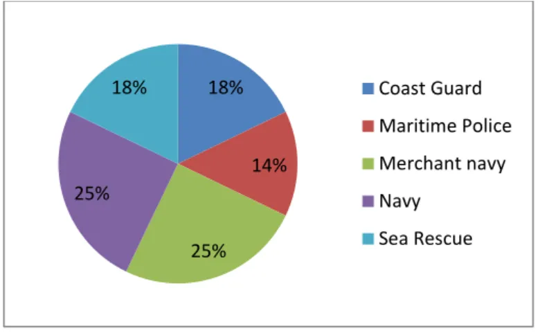
Paper I: Describes how navigation is performed on naval, commercial, coast guard and sea rescue vessels. It aims to perceive the practice of maritime navigation from the ship’s perspective. The research contributes to the development of the contextual framework, establishing the interaction between maritime stakeholder’s motivations and decisions made in maritime navigation. It also helps to clarify how safety is achieved and perceived by the different components of the socio-technical system.
5
Paper II: describes the interaction between humans and specific technological interfaces. The study was oriented to the most common information system which are visual displays. The research aims to assess some specific system design concepts. These concepts can later be used, together with the results of papers I and III, to develop new navigation methodologies.
Paper III: Considers how non-technical skills are used by teams in support of navigation functions and how they can be developed in simulators. This research also provides valuable insights on training needs and identification of new strategies to be applied in Maritime Education and Training (MET).
7
2 Maritime Navigation
2.1 Describing maritime navigation
Maritime navigation is an activity embedded in a very complex, large scale and multinational socio-technical system (Grabowski, You, Song, Wang, & Merrick, 2010; Mansson, Lützhöft, & Brooks, 2016; Schröder-Hinrichs, Praetorius, Graziano, Kataria, & Baldauf, 2015). On sea going vessels, teams are commonly multicultural, available technologies and systems vary, communication and interactions rely on electronic and digital systems, and the natural environment can be very stressful. Besides these issues, daily uncertainties and disturbances make maritime navigation a dynamic and complex critical system (Perrow, 1984; Vicente, 2004).
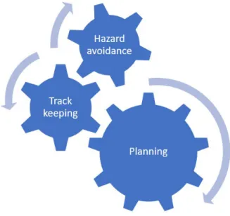
Onboard, the bridge team must guide the vessel from one location to another safely and efficiently. To do it safely, it must avoid all kinds of hazards, e.g. traffic or bad weather, to avoid damages to the ship or to the natural environment. They must also be efficient to minimize the operational cost. As represented in Figure 2, any voyage requires at least three concurrent functions: planning, track keeping and hazard avoidance. Prior to the voyage, the team must not only compute its length and duration, but also to appraise the location of dangers and the available resources to set the best route. During the execution, they must certify that the plan is followed and make the necessary arrangements to avoid new dangers or deal with new contingencies.
Figure 2 - Conceptual representation of navigation main functions.
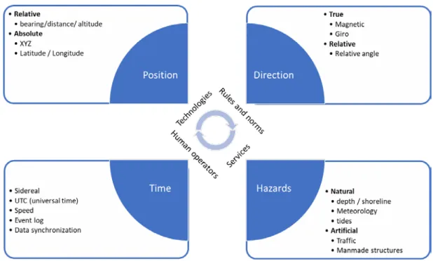
Regardless of the navigation methods and available tools, the basic problems of navigation always involve the determination of position, direction and distance (Cutler, 2004). In the maritime domain, this requires knowledge of position, direction, time and hazards. Figure 3 depicts some of the characteristics of these elements, where distance is related to time, speed and positions. One should note that sometimes it’s more important to know how the ship is in relation to the hazards than knowing the ship’s absolute position, i.e. its geographical
8
coordinates. For instance, when the ship sails within the channel’s marked limits, the precise position may not be known. However, it is certainly transiting within a safe area.
Figure 3- The basic elements of navigation.
To solve navigation problems, the navigator and his team have at their disposal several instruments and technologies, regulations and norms to follow, human resources and shore based services from different sources (Copetrans & CETMO, 2012; Morgas, Kopacz, & Urban, 2008). Onboard, the technological tools help with the observations required for the determination of position, direction and time. The position may be determined by several means, for instance with a sextant, an accurate clock and astronomical publications, or by electronic means using a GPS receiver. To relate ship position with hazards, the navigator needs to plot the position on a nautical chart, or to combine a GPS with an electronic chart system (ECDIS – Electronic Chart Display and Information System). Another way can be through direct visual observation or by taking bearings and distances, using compasses and RADARs. Nautical charts, as other nautical publications, are published by competent national authorities and are an example of required shore-based services. Nautical charts and sailing directions provide information on dangers, how to avoid them, and support the determination of positions. Other types of services are available to support the seafarers in the knowledge of existing dangers. Weather services provide information on existing and forecasted weather. Aids to Navigation authorities manage and provide visual aids, such as lighthouses and buoys, that are used to guide and inform the mariner about dangers. Other services, like the World Wide Navigational Warning Service (WWNWS) (IMO, 1991, 2008) and the Global Maritime Distress and Safety System (GMDSS) (IMO, 1995a), exist to alert the mariner about new dangers that were not known or predicted when the passage plan was made, such as storms, breakdown of visual aids, ships in danger or wrecks. This is technically known as Maritime Safety Information (IMO, 2009b).
9
Other systems are available to provide representation of the surrounding, like the RADAR used to detect and track other vessels or coastline, and the Automatic Identification System (AIS) to automatically share ship’s information such as name, position, course and speed. Shore based services, like Vessel Traffic Service (VTS) can also support the understanding of nearby situations and provide guidance.
The coordination of all these services and activities is supported by a regulatory framework, under the governance of IMO. SOLAS (Safety of Life at Sea) Convention, published by IMO, is the core document and Chapter V focus on the Safety of Navigation for all vessels at sea. It sets the general requirements for several nautical services, namely:
• Navigational warnings: to alert the mariners about any danger;
• Meteorological services and warnings: to disseminate weather information and warn ships of gales, storms and tropical cyclones.
• Hydrographic services: to publish, disseminate and keep up to date all nautical information necessary for safe navigation;
• Ships' routeing: to establish an international and mandatory systematic way to establish predetermined routes that ships must follow to avoid hazards to navigation at sea; • Vessel traffic services: to assist traffic through navigation advice and assistance on
request, and providing traffic organisation services in some areas; The same Chapter V of SOLAS, also establishes:
• Principles relating to bridge design, design and arrangement of navigational systems and equipment and bridge procedures;
• Carriage requirements for shipborne navigational systems and equipment; • Rules for conducting safe navigation.
Another relevant convention adopted by the IMO and related with execution of navigation, is the Convention on Standards of Training, Certification and Watchkeeping for Seafarers (STCW) (IMO, 2011), establishing common standards of competence for ship masters and other seafarers. To prevent collisions at sea, vessels have to follow the Collision Regulations (COLREGs) (IMO, 2003a). Finally, to ensure safe operation of ships and for pollution prevention, IMO issued guidelines and standards for shipboard safety management: the International Safety Management (ISM) Code (IMO, 2014a).
While IMO has established the general principles for shore-based services and shipboard arrangements, more comprehensive recommendations and guidelines are provided by other international organisations. The International Association of Marine Aids to Navigation and Lighthouse Authorities (IALA) deals with Aids to Navigation, including VTS, AIS and differential global positioning systems (DGPS). The International Hydrographic Organization (IHO) establishes standards for the production and provision of nautical charts and publications, together with electronic charts.
10
The size and organization of the bridge team varies depending on the type of vessel, operation and navigation area. On smaller boats or fishing vessels, a single operator commonly deals with all the tasks. As they become larger or engaged in specific operations, two operators are needed, distributing the tasks of navigation, piloting (taking the control of the heading and speed) and command. This arrangement is seen in numerous types of vessels and operations, some requiring precise coordination, like high speed navigation (Forsman, Dahlman, & Dobbins, 2011). In some cases, the ship’s team receives the collaboration of a harbour pilot, who provides enhanced local knowledge and facilitates local coordination with VTS and tugs. This joint activity has been explored by recent empirical studies (de Vries, 2017; Mansson et al., 2016; Mikkers, Henriqson, & Dekker, 2013; van Westrenen, 1995; van Westrenen & Praetorius, 2014; Wild, 2011).
Considering the minimum-manning standards for SOLAS vessels, on the smallest vessels navigating off coast, we may find the Master, one helmsman plus a lookout. When in confined waters, the bridge team organization mostly depends on the ships manning (Wild, 2011), however we expect to have, at least, the master in command, a conning officer (control of the ship), a harbour pilot, a deck officer monitoring the position, a deck officer for anti-collision assessment (in some cases a single deck officer is in charge for both position and anti-collision functions), a lookout and the helmsman. External communications are usually undertaken by the master or pilot, and larger vessels may designate an additional deck officer.
On navy vessels, we find larger teams, with very similar navigation equipment to the one used by SOLAS ships, even though some may have enhanced capabilities and they don’t have to comply with most of the international standards. Hutchins’ (1995) study gives a very compressive description of the bridge and navigation team work of navy ships. On sea going voyages, the bridge team usually comprises one or two officers, one chief at the navigation chart, one helmsman, one rating for propulsion controls, two lookouts and one rating for event log. When in confined waters, the navigation team, headed by the ship’s navigator, takes control and the bridge team is reinforced with one officer for anti-collision and another for position monitoring. The captain is on the bridge on these occasions.
Crew Resource Management (CRM) training programs were developed in aviation, to improve safety and efficiency in operations, using all available means such as information, equipment, and people (Kanki, Helmreich, & Anca, 2010, p. 5). This instructional framework was later introduced in the maritime context, with the designation of Bridge Resource Management (BRM), sometimes also referred to as Bridge Team Management (Swift & Bailey, 2004). This framework has been used to develop bridge navigation team’s performance through the enhancement of a shared mental representation (Brun et al., 2005). However, some studies have identified some lack of effectiveness of BRM in comparison to CRM in other domains (O’Connor, 2011; Salas, Wilson, Burke, & Wightman, 2006). O’Connor (2011) proposes that this is due to a deficient assessment of maritime user’s needs and subsequent fragilities in adapting the CRM program framework.
11
Due to the advances in information and communication technologies and global satellite positioning systems, along with the establishment of higher performance standards of efficiency and safety, new systems were introduced on the bridge since middle 90’s, namely:
• The Global Navigation Satellite System (GNSS) receiver (e.g. GPS, GLONASS, DGPS) (IMO, 2000a, 2000b, 2000c, 2000d, 2001) for use at all times throughout the intended voyage to establish and update the ship’s position by automatic means.
• The Automatic RADAR Plotting Aids (ARPA) (IMO, 1995c, 2004) represents an enhancement of the traditional RADAR, to improve collision avoidance performance, by reducing Officers’ of the Watch workload, enabling automatic and continuous detection and tracking of targets, providing accurate and rapid computations with alerts.
• The Electronic Chart Display and Information Systems (ECDIS) (IMO, 1995b, 1998, 2006c) which is a navigation information system, that can comply with the requirement of the up-to-date paper nautical chart set by the SOLAS Convention, displaying selected information from a System Electronic Navigational Chart (SENC) with positional information from navigation sensors to assist in route planning and route monitoring. • The Integrated Bridge System (IBS) (IMO, 1996) which allows centralized access to sensor
information or command/control from workstations, supporting passage execution, communications, machine control, cargo control, safety and security. The IBS usually includes: autopilot, Dual Radar/ARPA, Gyrocompass, Position fixing systems, Dual ECDIS setup, Conning Display (displaying information that summarises the important navigational sensors), Power distribution system, Steering gear and GMDSS.
• The Integrated Navigation System (INS) (IMO, 1998, 2007c) which supports the navigator by providing enhanced functional capabilities and information needed to plan, monitor or control the movements of the ship. This system was designed to address mariners’ situation awareness and workload, by evaluating inputs from several independent and different sensors, combining them to provide information, giving timely warnings of potential dangers and degradation of integrity of this information.
• The Bridge Navigational Watch Alarm System (BNWAS) (IMO, 2002e) monitors the awareness of the OOW and automatically alerts the Master or another qualified OOW if for any reason the OOW becomes incapable of performing his duties. This is achieved by a series of indications and alarms to alert first the OOW and, if he is not responding, then to alert the Master or another qualified OOW.
• The Automatic Identification Systems (AIS) (IMO, 2002c, 2002d, 2003b, 2007a) assists the bridge team in vessel identification, target tracking and information exchange with other vessels and shore services, using digital data-link communications. Thus, it aims to improve situational awareness by the provision of additional information derived directly from ship-born digital systems. Yet, not all ships are required to carry this system, and it has several integrity issues, related with data availability and reliability (Calder & Schwehr, 2009; Harati-Mokhtari, Wall, Brooks, & Wang, 2007; Last, Bahlke, Hering-bertram, & Linsen, 2014; Schwehr, 2011).
12
Figure 4 - Context elements of maritime navigation.
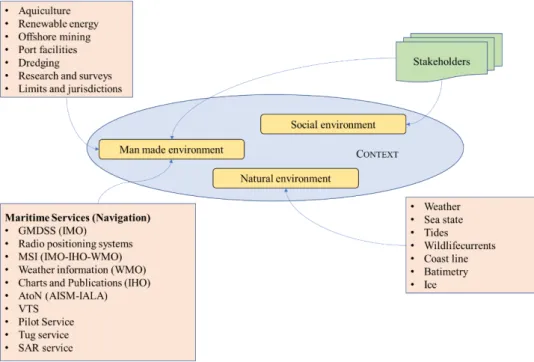
Summarizing, maritime navigation is a safety critical complex activity, occurring in a context shaped by social influences, conditioned by manmade structures and exposed to natural circumstances. The diagram in Figure 4, depicts some of the numerous elements which contextualize the settings of maritime navigation. The next section provides a closer look at relevant players and their influence in maritime navigation.
2.2 Who are the players and stakeholders?
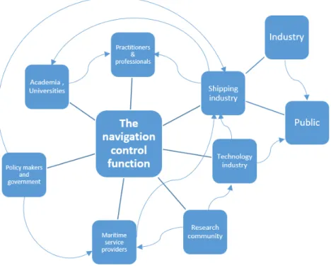
The arrangements made to support maritime navigation functions are influenced and managed by numerous players, each with their own motivation and goals. The diagram in Figure 5 tries to represent the stakeholders and their main relations. Clarifying who are the stakeholders provides a better understanding of what drives and shapes the way maritime navigation is done. Some players are always present, like the mariner who will use the new technologies or the shipping industry that will have to purchase, manage and make a profit with the ships.
Other stakeholders have regulatory roles, providing norms and guidance that must be followed by all. These are governmental agencies and national or international policy makers, e.g. IMO, International Association of Marine Aids to Navigation and Lighthouse Authorities (IALA), International Hydrographic Association (IHO), World Meteorological Organization (WMO). The provision of technology to support navigation requires industry and researchers. The establishment and maintenance of technical standards for the construction and operation of ships is done by classification societies, and other international specialized agencies such as the International Organization for Standardization (ISO), International Telecommunication Union (ITU) and National Marine Electronics Association (NMEA).
13
Figure 5 - Framework of the Stakeholders related to the topic of the research.
The shipping industry, once handed the norms to perform their activities, will have to set the professional requirements for the practitioners, which will be used by universities when designing their courses. Additionally, we may find second level stakeholders, such as the public and general industry, since the shipping industry’s impact over the labour market and over the cost of the tradable goods is quite significant. Lastly, some of these stakeholders may have divergent interests and motivations, which need to be considered when assessing new technologies and regulations. On December 2017, to assure leadership in the promotion of ship energy-efficiency technologies and operations, IMO launched the creation of a global network of centres of excellence in marine technology (Global Maritime technologies cooperation centres Network - GMN).
2.3 Maritime Navigation in the XXI century
Over the last two decades, ship bridges have changed very much due to the rapid development of new technologies. These changes are inducing silent transformations in the navigator’s role, which demands a review of the maritime navigation process (Belev, 2010; Chawla, 2014; Kopacz, Morgaś, & Urbański, 2004; Peterson, 2002). More recently, automation, broad band communications and internet as led to the possibility of using remote and unmanned vessels, bringing additional challenges (Wahlström, Hakulinen, Karvonen, & Lindborg, 2015).
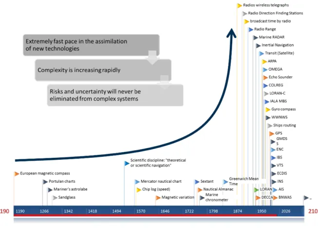
This trend in maritime navigation technology, highlighted in Figure 6, has opened-up a discussion on how to redefine the way ships are operated and designed. Despite the common acceptance of the advantages brought by digital information and computing technology, the overall complexity of technological support systems and regulatory framework for marine navigation emphasizes the need for a new system design. The increased complexity of modern
14
technological system is an important driver of Cognitive System Engineering (CSE) development (Hollnagel & Woods, 2005).
Figure 6 - Time line visualization of the trend in maritime navigation technologies and techniques.
The role of the navigator is shifting to tasks more related with setting goals, planning and monitoring, since execution and surveillance are being undertaken by automated systems such as the autopilot or automatic detection and tracking RADAR (ARPA - Automatic Radar Plotting Aid). From the taxonomy proposed by Endsley and Kaber (1999; Kaber & Endsley, 2003), this arrangement of functions between human operators and automated systems corresponds to higher levels of human machine dependency: Automated Decision Making and supervisory control.
Nonetheless, navigation at sea is not simply a computational challenge. The masters frequently face critical decisions that push them to the limits of safety, sometimes crossing those limits because of reasons not directly related to navigation. The issue of ethical decision-making was discussed by Moore (Moore, 2000), suggesting that it should be part of the masters education programs. More recently, following the accident of the cruise vessel Costa Concordia, several media reports questioned the existence of some code of conduct in the shipmaster community (Pawlik & Wittig, 2012). Such a written code does not exist. However, those concerns within the professional community and society came at the right time, since the principles of a such code should balance ship-owners’ goals with the captain’s responsibilities towards environmental issues or human lives. Some may think that the use of unmanned vessels will solve this problem, but ethics might be the main motive to justify the continuity of some kind of traditional ship captain.
15
Alterations in navigation tasks are stressed by the huge amount of data and information provided by on-board sensors, databases and shore based maritime services, leading to rising apprehensions about the workload and its effects on situation awareness and decision making (Endsley & Kaber, 1999; Hicks, Durbin, Morris, & Davis, 2014; Kaber & Endsley, 2003; Woods, Patterson, Roth, & Christoffersen, 2002). Bainbridge (1983) identified several automation glitches, such as over reliance, trust and feedback in human-machine collaborations, and drop of human’s motivation and skills when engaged in monitoring tasks. The relevance of automation feedback and representations of ship’s behaviour was highlighted in a study based on the grounding of the Royal Majesty (Lützhöft & Dekker, 2002). The same study points out the need for changes in the information systems to present new forms of highlighting changes and events, supporting the anticipation of changes, and facilitating the cognitive work involved in searching and scanning the displays.
Maritime navigation turned out to be a very complex and large-scale socio-technical system comprising human and man-made entities that interact with each other and operate in a rough environment (Mansson et al., 2016; Perrow, 1984; Vicente, 2004). Improving the maritime navigation performance requires the understanding of how the process works and its context. Therefore, we should address this problem as a joint human-technological activity (Hollnagel & Woods, 2005; Woods et al., 2002) or as “system of person-in-interaction-with-technology” (Hutchins, 1995). Some challenges were identified by Klein et al. (2004) for the success of human-agent team activities, comprising issues like mutual predictability, common ground, visible status and intentions, attention management, collaboration and negotiation. The thinking, computation and the decision-making processes are no longer only dependent of the operator himself but are also socially distributed among the elements of the team. These processes are made by individuals and cognitive tools available in Socio-technical Systems (Hutchins, 1995).
To develop a collaborative spatial decision-making tool, Antunes et al. (2010) overviewed several decision models to derive six different requirements: the support of perception, retention, knowledge externalization, divergent/convergent activities, recognition and task/pattern management. The collaborative view of this human-technological system leads to the assumption of an ecological design perspective (Flach, Vicente, Tanabe, Monta, & Rasmussen, 1998; Rasmussen & Vicente, 1989; Vicente & Rasmussen, 1992), where navigation functions are directed by the contextualized joint human-automated system, in contrast to the traditional navigator egocentric design.
2.4 e-Navigation
According to the e-navigation strategy (IMO MSC, 2009, p. 180), eight key elements were set, based on user needs: Architecture, Human Element, Conventions and Standards, Position Fixing, Communication Technology and Information Systems, Electronic Navigational Charts, Equipment Standardization, and Scalability. The Human Element needs more attention across all the maritime stakeholders, as it must consider several aspects, such as: training, competency, language skills, workload, motivation, alert management, information overload, ergonomics, and usability. IMO anticipates that ships shall profit from system and sensors integration,
16
standardization of user interfaces, and a comprehensive alarm system. The central element of this system shall be the active engagement of the mariner in the navigation process loop (IMO MSC, 2009, p. 174).
The recently formed Sub-Committee on Navigation, Communications and Search and Rescue, from IMO, proposed an e-navigation Strategy Implementation Plan (SIP), setting up a list of tasks and specific timelines for the implementation of prioritized e-navigation solutions during the period 2015-2019 (IMO NCSR, 2014). Two of the solutions, solution S1 (improved, harmonized and user-friendly bridge design), and solution S3 (improved reliability, resilience and integrity of bridge equipment and navigation information), endorse the workable and practical use of information and data onboard.
Over the last decade, maritime stakeholders have had many debates over the e-navigation concept and the development of its implementation framework. All over the world, several research projects are bringing valuable contributions to the consolidation of this conceptual vision. At the same time developments in navigation and communication technologies are still evolving at a growing rate. Nowadays as automated systems are flooding ship bridges with information, mariners and industry are demanding more system integration and harmonized standards. However, as previously noted, complexity is increasing, not only onboard but also ashore, and most of the identified problems that are human factor related are still present.
2.5 Safety in navigation
Over the last decades, we have seen the introduction of new technologies in bridges, such as marine radar with Automatic Radar Plotting Aid (ARPA) capability, AIS, ECDIS, Integrated Navigation Systems, IBS, BNWS and other decision support tools. Additionally, many and everchanging regulatory frameworks, such as STCW, SOLAS, COLREG conventions and other safety management systems have been introduced. Even though they were implemented to increase navigational safety, they have also supported the enhancement of the overall efficiency and productivity. The focus on efficiency and productivity led however to a neutralization of their initial safety goals, inducing new types incidents and accidents (Kataria & Praetorius, 2014; Perrow, 1984). On the other hand, the impact of current CRM training on safety is still not clear, since more studies are required to sustain its claim to enhance safety (Salas et al., 2006).
It is now largely recognized that there are multiple factors correlated with the origin of accidents in complex systems. Usually it is their joint influence that triggers the accident. Several human factors have been identified in the maritime safety domain, such as: fatigue, automation, situation awareness, mental workload, communication, decision making, human–machine interaction, team work, organizational failure, health and stress (Chauvin, 2011; Grech et al., 2008; Hetherington et al., 2006; Schröder-Hinrichs, Hollnagel, Baldauf, Hofmann, & Kataria, 2013).
Along with the problems of standardization and self-regulation in high risk systems, described by Le Coze (2017), Psaraftis (2002) argued that the vast array of stakeholders involved in
17
maritime safety policy encourages situations like over-regulation, overlaps, inconsistencies and gaps in the regulatory framework.
By studying the crew’s perspective of maritime safety, Praetorius and Lutzhoft (2011) concluded that safety is supported by the capability of Joint Cognitive System (JCS) to maintain control. Furthermore, it is considered that safety can also be an emergent property of the system based on the interaction of all the participating agents: operators and technologies.
Reason’s (Reason, 1995, 2000) and Rasmussen’s (1997) influence in the systemic and organisational perspective of safety in complex technological systems set the ground for the development of several accident analysis methodologies focused on human factors, such as the Human Factors Analysis and Classification System (HFACS) of Shappell & Wiegmann (Shappell & Wiegmann, 2000). The HFACS framework was later on adapted to the maritime domain (Akyuz & Celik, 2014; Celik & Er, 2007) and applied for the studies of occupational accidents in shipyards (Celik & Cebi, 2009), organisational factors in maritime accident investigation (Schröder-Hinrichs, Baldauf, & Ghirxi, 2011), and analysis of collisions at sea (Chauvin et al., 2013).
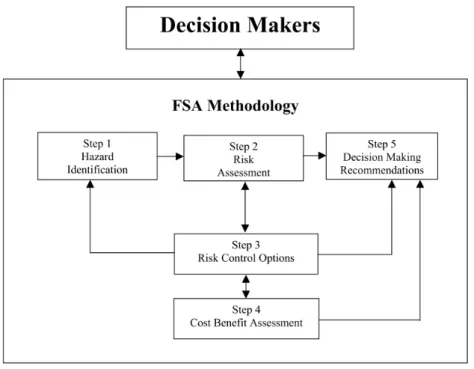
With the purpose of enhancing maritime safety, IMO proposed its own structured and systematic methodology – the Formal Safety Assessment (FSA) (IMO, 2002a, 2002b), yet with no reference to empirical data, or its systematic analysis (Mullai & Paulsson, 2011). The FSA comprises 5 steps to support the conception of new regulations, as illustrated in Figure 7. Psaraftis (2002) noted that this framework is difficult to apply and used randomly, in part due to the constraints surrounding the policy-making process. This framework for safety and risk assessment, inspired the development of a system approach for the assessment of e-navigation technologies (Hahn, 2014). It provides a modelling framework for processes, fault trees and generic hazard specification, including a physical world and maritime traffic simulation system.
18
Another systemic, however non-linear model, is Hollnagel’s Functional Resonance Analysis Method (FRAM) (Hollnagel, 2007; Hollnagel, Hounsgaard, & Colligan, 2014) which characterizes socio-technical systems by the functions they perform rather than by trying to capture the causes and effects relationships. Consequently, it stands to provide a better understanding of the complexity and functioning of the socio-technical systems, and therefore a greater perception of how the factors interact and contribute to the origin of accidents. FRAM has been applied in empirical studies addressing navigational safety in the maritime Socio-technical System (de Vries, 2017; Praetorius, Hollnagel, & Dahlman, 2015), bringing detailed description of functions and potential success factors within complex Socio-technical Systems. Grabowski et al. (2010) attempted the development of a framework that could present early warning information of adverse critical events, based on the assessment of safety culture and performance in maritime transportation. In their work, they identified significant correlation of safety factors with safety performance, namely: hiring quality people, safety orientation, promoting safety, a formal learning system, communication, problem identification, vessel feedback, empowerment, anonymous-reporting, and individual-feedback.
In two reviews of maritime accident models (Hetherington et al., 2006; Mullai & Paulsson, 2011), authors identified methodological issues with the research undertaken in the maritime safety domain. The problems where related with ecological validity of previous research, access to observation data, under-reporting of accident or incident data, large proportion of retrospective work, and the fact that several accident models are based on theories that may not take account of complex systems and phenomena. Schröder-Hinrichs et al (2011) also identified significant data gaps with regard to organizational factors.
Grounded on the concepts of resilience engineering (Hollnagel, Pariès, Woods, & Wreathall, 2011; Hollnagel, Woods, & Leveson, 2006) and safety II (Hollnagel, 2014), and through the investigation of IMO human factor regulations, Schröder-Hinrichs et al. (2013, 2015) discussed the need to change the traditional view of maritime safety. They argue that the improvements in maritime safety have been determined by reactive responses to adverse events, trying to remove the causes of vulnerabilities. In their view, a smooth shift is necessary to introduce the safety II approach, avoiding dramatic breakdowns in the current framework and keeping valuable instruments that are in place.
A new kind of safety thinking is required, placing humans as the source of diversity, insight, creativity, and wisdom about safety, not as sources of risk that undermine an otherwise safe system (Dekker, 2014). Thus, the design of the maritime navigation system must see the navigator as solution for enhanced control and safety cannot be only a bureaucratic process, but it has to be an ethical responsibility. Additionally, we have to leave the Cartesian-Newtonian view of linear cause-effect, and consider the complexity, unpredictability and variability of the interactions of the system components (Dekker, 2014; Taleb, 2010).
2.6 Modelling the navigator
The most widely used manuals of maritime navigation (Bowditch, 2002; UK Ministry of Defence (Navy), 2008), identify the key navigation tasks as: setting objectives, planning,
19
execution, monitoring, and revising or adapting the plan. From a different view, Jul and Furnas (1997) proposed a navigator model which considers the following nonlinear tasks: setting a goal, selecting a strategy, collecting information, perception, assessing, creating a cognitive map and moving. The last four tasks represent the wayfinding/motion loop. Darken and Peterson (2001) defined wayfinding as the cognitive element of navigation, involving the formation of strategies and tactics that will guide the movements. The development and use of a cognitive map is an essential element of wayfinding. In this view, they consider navigation as the aggregate task of wayfinding and motion. Bjerva and Sigurjónsson (2016) proposed another concept of wayfinding and suggested that it comprises three steps: cognitive mapping, wayfinding plan development, and physical movement. Based on observations of pilots’ mental workload, van Westrenen (1995) proposed a navigator model with a three-stage decision model, comprising tracking, short-term planning and term planning behaviour. In this view, long-term planning concerns mostly voyage planning, prior to sailing, and can be associated with the previous concept of goals setting and strategy selection. Short-term planning, comprises local observation and information collection necessary to make decisions over the control of the vessel. Tracking corresponds to the assessment of the movement and correlation with the initial plan. van Westrenen and Praetorius (2014) also suggest that each of these stages corresponds to three different types of control systems, used in diverse domains. Whereas strategical system refers to resource selection, tactical system is about the deployment of resources to provide capabilities, and control refers to the use of means to reach a desire state.
In the view of control theory, distributed control emerges from the increased interaction between agents. Distributed control supports self-organization and adaptability when facing uncertainty or unpredicted constraints (Flach, 2012; van Westrenen, 2004). Time and predictability are major determinants of such control systems (Hollnagel & Woods, 2005), thus in situations of low predictability and available time we will tend to find reactive decisions, where operators respond without having foreseen all the events.
In a different approach, Wolbers and Hegarty (2010) studied the interacting mechanisms that determine the individual’s navigational abilities in cognitive and perceptual factors, neural information processing and variability in brain microstructure. They further suggested that spatial navigation involves sensory cues (environmental and self-motion), computational mechanisms (spatial computations and executive processes) and spatial representations (online and offline).
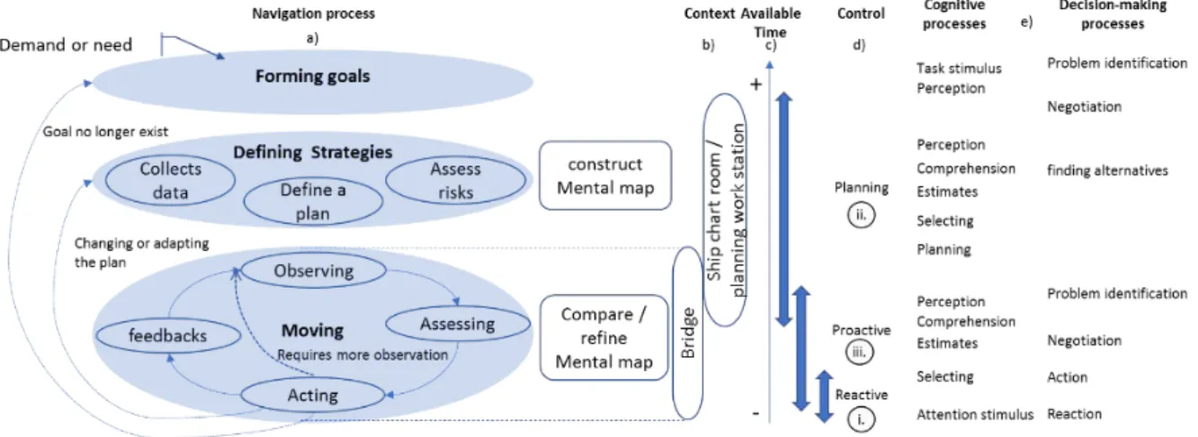
The conceptual navigation model adopted for this study may be visualized Figure 8a). It comprises three main functions: forming a goal, defining strategies and moving. Several nonlinear tasks are required in each stage and, all of them, have deliverables (goals, plan and control actions over ship). To support the categorization of visualization factors, the process of navigation is contextualized in the work space, Figure 8b), and available time, Figure 8c), together with expected control modes, Figure 8d), cognitive and decision-making processes, Figure 8e).
As an example, while sailing, the navigator tries to minimize reactive decisions (i.), as they are not thoroughly thought, they are usually linked to emergency situations and can only be well
20
made thru experience and training. Since it is impossible to eliminate all the uncertainties, it might be worth to better prepare the ship for those events. Thus, a sound planning is the first mitigation measure (ii.), supported by cognitive processes that help to build a cognitive map of the physical voyage. At the same time, several alternatives are considered and tested. These processes will further support the perception and understanding of the real world (iii.), and control is based on planned responses or projected events.
Figure 8 - Identifying the cognitive and decision-making processes within the navigation functions.
Information systems should be designed to support the identified cognitive and decision-making processes, considering the navigation function, context and available time. For instance, observing Figure 8, we can see that in the most front-end stage, when piloting the ship, events are occurring in the bridge and typical control modes are reactive and proactive. These control modes require continuous attention to stimulus and the operator must react in a short time. From this case, we may argue that by enhancing attention abilities we improve the reaction capabilities. We may also focus on higher stage processes, such as enhancing estimation and understanding cognitive processes, so the operator will use the proactive control mode, based on predictions that support better decisions.
21
3 Theoretical framework
The pursuit of more efficient and safer systems provided by increasingly complex technological systems, forced humans to constantly learn and adapt to new and unforeseen problems and shortcomings (Cilliers, 2002; Perry, Wears, & Cook, 2005; Woods & Dekker, 2000). Consequently, more important than blaming defective decisions or loss of Situation Awareness, is the understanding of how human factors are related to them (Dekker, 2014). We need to change the perspective of safety. Things go wrong due to latent failures of complex systems – system accidents (Dekker, 2011; Perrow, 1984), and rather than only pursuing accidents’ causes we must address the success factors to deal with failures (Hollnagel, 2014). Hollnagel’s ETTO Principle - Efficiency-Thoroughness Trade-Off, claims that we must consider both success and failure situations, since they are originated by the same reasons. However we should be focused on understanding why things didn’t go right instead of why they did go wrong (Hollnagel, 2009).
3.1 System theory
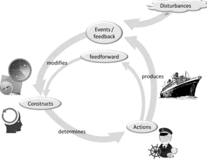
Ehrenfels’ celebrated thought “The whole is more than the sum of its parts”, reflects the view of system thinking, where connectiveness, relationship and context becomes central elements. By 1940, biologist Ludwig von Bertalanffy (1950) formulated the framework of general system theory. Inspired from the biological sphere, he took the properties of holism, organicism, directiveness, and open systems, and revealed that they were shared by all kinds of natural and social complex systems (Bertalanffy, 1968). System elements are in mutual interaction, adapting and working together towards a purpose, which means they are goal-oriented or teleological (Bertalanffy, 1968; Skyttner, 2005). In open systems, the stabilization of the end state can be reached by different manners and initial states, varying the dynamics of the system. Maintaining a stable characteristic or goal state requires feedback processes, working as a control mechanism for self-regulation and self-organization (Bertalanffy, 1968). These cybernetic concepts, were introduced by Wiener (Wiener, 1965) in 1948, while working on communication and control in complex system, especially in closed loops and networks. Bertalanffy (1968) pondered two levels of mechanism for system stabilization, one initially evolved from system dynamics regulation as an open system, and secondly the feedback mechanism that supports homeostasis and goal oriented behaviour. Cybernetic’s feedback processes were later found useful in social system, such organizations (Wiener, 1965), looking for the understanding of work partition, communication between sub-systems, control systems and coordination toward organization goal (Skyttner, 2005).
General system theory goals include framing theories on system dynamics, goal-seeking behaviours and control processes. It also looks for the formulation of methodologies to explain the functioning of the system (Skyttner, 2005). Through synthesis, it aims to explain the properties or behaviour of an identified part or function of a system (Skyttner, 2005). System thinking brought a perceptual shift, focusing on the whole, looking at relationships between the parts, taking multidisciplinary and qualitative approaches, mapping patterns and processes (Capra & Luisi, 2014, p. 81). The essential elements of a system are the emergent properties
22
found in patterns of the whole system and inexistent among the parts. If the relationships and interactions are destroyed the system properties are lost and the system fails.
The technological advances that nearly drown us in information, have also contributed to unforeseen changes in human and social behaviour, increasing the complexity by speeding adaptation and increasing connectedness. (Page, 2012; Vicente, 2004). Risk will never be eliminated from complex systems, due to their interactive complexity and tight coupling characteristics, reason why, when designing the systems, the strategies should be oriented in the view of managing the risk (Perrow, 1984). Hollnagel (2013) suggest that in tightly coupled systems, buffers and redundancies are part of the design, sequences are invariant and impossible to delay, with little slack opportunities. The demands of the Law of Requisite Variety (Ashby, 1958) challenges the design of systems that effectively control or manage complexity (i.e., that destroy variety) (Flach, 2012). Hierarchical, centralized control systems have severe limitations when coping with complexity (Flach, 2012). The way forward is to support the creative capacities of the humans, incorporate their wisdom, so we may provide the solutions in real time to problems that could not have been anticipated in advance (Flach, 2012; Page, 2012).
3.2 Joint activity
“A joint activity is defined as an activity carried out by an ensemble of people acting in coordination with each other” (Clark, 1996b, p. 3). Joint activity requires the existence of participants, roles, actions timing, commitments and a common ground of that activity (Clark, 1996a; Clark & Brennan, 1991). Klein and his colleagues, when generalizing these concepts to describe key aspects of team coordination, consider an activity as a “set of actions” (Klein et al., 2004) or a “set of behaviours” (Klein, Feltovich, Bradshaw, & Woods, 2005). From activity theory, Bedny and Harris (2005, p. 130) define activity as goal-directed system, where cognition (internal processes), behaviour (external processes), and motivation are integrated and organized by a mechanism of self-regulation toward achieving a conscious goal. The goal is the desired result or outcome of the activity and defines the object being manipulated and explored by the humans.
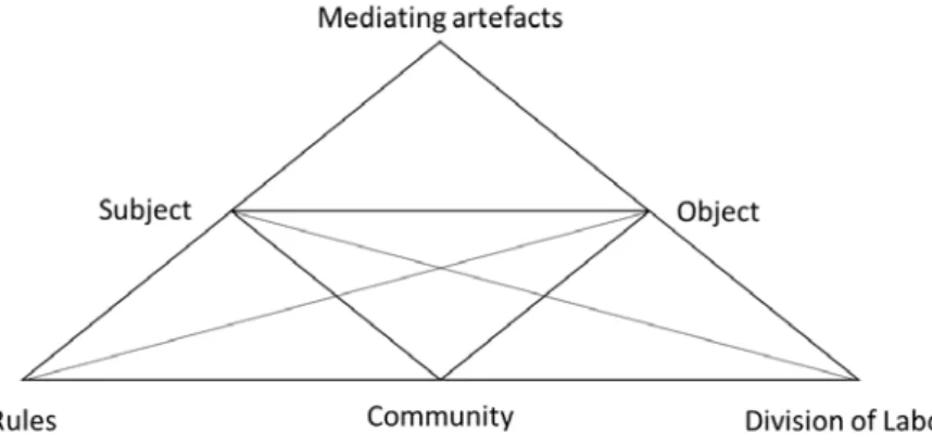
From the viewpoint of cultural-historical activity theory, an activity system comprises a minimum set of elements, including the object, subject, mediating artefacts, rules, community and division of labour (Engeström, Miettinen, & Punamäki-Gitai, 1999, p. 9). This framework, represented in Figure 9, offers a methodology to analyse human work in his contexts. It studies the interactions between the humans (subjects), the tools (mediating artefacts) being used and social shaping elements (rules, community and division of labour) (Cole & Engeström, 1993, p. 8). It considers two main types of activity, object-oriented and subject-oriented (also known as social interactions) (Bedny & Karwowski, 2004). Social interactions involve the understanding and comprehension of other subjects’ activities and goals. The same goal may be commonly shared by different activities, but related activities from several levels may also support a more strategic goal.