eISSN: 2171-9845 http://dx.doi.org/10.5424/fs/2016252-09293 Instituto Nacional de Investigación y Tecnología Agraria y Alimentaria (INIA)
ResouRce communication oPen access
temporal optimisation of fuel treatment design in blue gum
(Eucalyptus globulus) plantations
Ana Martín1, Brigite Botequim2*, Tiago M. Oliveira3, Alan Ager4, Francesco Pirotti5
1 Sustainable Forest Management Research Institute University of Valladolid-INIA, Avda de Madrid 44, 3004 Palencia, Spain. 2 Centro de
Estudos Florestais (CEF), Instituto Superior de Agronomia, Universidade de Lisboa (UL). Edificio Mário de Azevedo Gomes Tapada da Ajuda, n/s, 1349 - 017, Lisboa, Portugal. 3 The Navigator Company, Forest Protection Department, Apartado 55, 2901-861 Setúbal,
Portugal. 4 USDA Forest Service, Rocky Mountain Research. 5775 Highway 10 West, Missoula, MT 59808 USA. 5 Università degli Studi di
Padova, Dipartimento Territorio e Sistemi Agro-forestali. Viale dell’Universita, 16, 35020, Padova, Italy
abstract
Aim of study: This study was conducted to support fire and forest management planning in eucalypt plantations based on
eco-nomic, ecological and fire prevention criteria, with a focus on strategic prioritisation of fuel treatments over time. The central objec-tive was to strategically locate fuel treatments to minimise losses from wildfire while meeting budget constraints and demands for wood supply for the pulp industry and conserving carbon.
Area of study: The study area was located in Serra do Socorro (Torres Vedras, Portugal, covering ~1449 ha) of predominantly Eucalyptus globulus Labill forests managed for pulpwood by The Navigator Company.
Material and methods: At each of four temporal stages (2015-2018-2021-2024) we simulated: (1) surface and canopy fuels,
timber volume (m3 ha-1) and carbon storage (Mg ha-1); (2) fire behaviour characteristics, i.e. rate of spread (m min-1), and flame
length (m), with FlamMap fire modelling software; (3) optimal treatment locations as determined by the Landscape Treatment Designer (LTD).
Main results: The higher pressure of fire behaviour in the earlier stages of the study period triggered most of the spatial fuel
treatments within eucalypt plantations in a juvenile stage. At later stages fuel treatments also included shrublands areas. The results were consistent with observations and simulation results that show high fire hazard in juvenile eucalypt stands.
Research highlights: Forest management planning in commercial eucalypt plantations can potentially accomplish multiple
objec-tives such as augmenting profits and sustaining ecological assets while reducing wildfire risk at landscape scale. However, limitations of simulation models including FlamMap and LTD are important to recognise in studies of long term wildfire management strategies.
Keywords: Eucalypt plantations; fire hazard; FlamMap; fuel treatment optimisation; Landscape Treatment Designer; wildfire
risk management.
citation: Martín, A., Botequim, B., Oliveira, T.M., Ager, A., Pirotti, F. (2016). Temporal optimisation of fuel treatment design in
blue gum (Eucalyptus globulus) plantations. Forest Systems, Volume 25, Issue 2, eRC09. http://dx.doi.org/10.5424/fs/2016252-09293.
Received: 13 Jan 2016. accepted: 05 May 2016
copyright © 2016 inia. This is an open access article distributed under the terms of the Creative Commons Attribution-Non
Commercial (by-nc) Spain 3.0 Licence, which permits unrestricted use, distribution, and reproduction in any medium, provided the original work is properly cited.
Funding: The authors received no specific funding for this research.
competing interests: The authors have declared that no competing interests exist. correspondence should be addressed to Brigite Botequim: [email protected]
the key businesses in Portugal (Soares et al., 2007). The culture of eucalypt has many other potential ben-efits including carbon sequestration (Botequim et al., 2013). However, commercial eucalypt plantations are inherently flammable due to the nature and accumula-tion of their litter and bark fuels with high levels of biomass, and thus prone to intense wildfires (Fer-nandes, 2009).
Portugal has the highest incidence of wildfires events in the Mediterranean basin (Pereira et al., 2014). Eu-calypt plantations accounted for 35.9% of all Portu-guese forest burned during 1996 - 2012 (Mateus &
introduction
Portugal is covered by 3.2 million hectares of forest, representing 34.5% of the total mainland area, and ranking eighth in Europe as highest country with forest-lands (ICNF, 2013). Portuguese plantations are domi-nated by eucalypt (Eucalyptus globulus Labill) encom-passing 812 thousand hectares (26% of the whole forested area), and constitute the main forest cover type in continental Portugal (ICNF, 2013). Eucalypt planta-tions are an important economic resource and support a large and significant pulp and paper industry, one of
Fernandes, 2014). These wildfires pose a significant impact on revenues and costs associated with eucalypt management scheduling (Ferreira et al., 2012). How-ever, appropriate management activities can reduce fuel loadings and alter forest structure to change wildfire occurency and reduce wildfire losses (Botequim et al., 2013; Marques et al., 2011). In particular, fuel reduc-tion methods for modifying fire behaviour have become a central management issue and are actively practiced by fire and forest managers in eucalypt stands to reduce wildfire risk (Botequim et al., 2013; Fernandes, 2015). Wildfire simulation methods provide a framework to quantitatively measure performance of the fuel treat-ments (Ager et al., 2010), and evaluate the effects of the fuel treatment planning on fire behaviour before and after the fuel treatment design. Large recent wild-fires have led to an increased interest in decision sup-port tools to mitigate wildfire risk. These include growth and yield modeling, wildfire behaviour models and optimisation approaches to assist managers in plan-ning and evaluating management decisions to support hazard-reduction fuel practices (Ager et al., 2012; Bradstock et al., 2012; Vogler et al., 2015).
Landscape-scale fuel treatments decrease fire in-tensity and fire growth rate, hence resulting in small-er and less sevsmall-ere fires (Fsmall-ernandes, 2015). Fuel reduc-tion treatments (e.g. thinning and prescribed burning) have long been identified as key to decrease fire size and fire severity (Agee & Skinner, 2005), and are a vital part of forest management. However, with lim-ited resources, it is necessary to prioritise where, when, and how fuel treatments should be applied across the landscape. Finney et al. (2006) addressed how fuel treatments placed in random and optimal spatial patterns affect fires behaviour. They found that strategic allocation of fuel treatments reduced the predicted growth rates of simulated fires under unfa-vorable weather conditions more effectively than random placement. Indeed, fire risk and wildfire dam-age can be reduced by removing or reducing fuels in strategic locations.
Where should the forest manager spatially invest in prevention? Which stands should be assumed for fire prevention treatment management? This study was conducted to monitor trends in wildfire hazard through strategic fuel treatment locations into a spatial-temporal analysis (2015-2018-2021-2024). The main interest was set at reducing the impact of wildfire as determined by fire hazard thresholds (rate of spread, m min-1), and
flame length (m) while considering wood supply (m3 ha-1) for the pulp industry and demands of carbon
values (Mg ha-1) with an annual budget constraint (or
area treated as surrogate) for the prevention activities in Serra do Socorro. The current framework was
de-signed taking into account several decision support tools used in the United States for wildfire risk management (e.g. FlamMap – Finney, 2006 and Landscape Treatment Designer, LTD - Ager et al., 2012). We used these tools in a three-tiered approach in Serra do Socorro (Centre Portugal). This research resulted in: (i) improved un-derstanding of the relative role of biometric variables (e.g. forest fuel load and stand structure) in fire behav-iour characteristics, with the challenge of incorporating such knowledge into fire-management planning; and (ii) information to help policy makers define a scien-tific approach to spatially and temporally prioritise fuel management interventions for minimising fire impacts, thus protecting eucalypt areas from burning without ecological and commercial timber values losses.
material and methods
the study area
The study area is located in Serra do Socorro (Torres Vedras, central Portugal) and covers ~1449 hectares (Fig. 1). Serra do Socorro is the steepest landscape in the municipality of Torres Vedras (Gabinete Técnico Florestal, Torres Vedras, 2015-2019). Topography is dominated by uplands and lowlands ranging from 51 meters to a maximum of 389 meters elevation, with an average value of 168 meters.
The area is characterised by a strong Atlantic wind influence and consequently, throughout the whole year, atmospheric humidity remains high which is espe-cially noticeable in summer when compared with other regions in Portugal (more than 70% relative humidity). In terms of temperature, the maximum (26 °C) is reached during August. Precipitation values, in the fire season (especifically during July and August), do not reach 7 mm as average value per month (values are given for the historical period 1961-1990) (Gabinete Técnico Florestal, Torres Vedras, 2015-2019).
The main forest land cover type is eucalypt planta-tions (175 ha) surrounded by small agriculture, shrub-lands and uncultivated land. These plantations are managed by The Navigator Company, the leading paper company in Europe. The site presents the fol-lowing land use classes: non burnable areas (5.9%), blue gum plantations (12%), extensive agricultural lands and pasture lands (56.7 %), shrublands (24%), pine stands (0.24%).
The municipality of Torres Vedras is considered under a low intensity fire regime with a long fire sea-son. Fire history in Torres Vedras is defined by a sig-nificant number of events, mainly in summer season (maximun in October) and small size (less than 1
for the case of eucalypt slash were assigned to obtain the surface fuel map of the study area (2015, t=0). Urban areas and structures, water streams, irrigated agricultural lands, roads and forest roads were classi-fied as non-burnable (fuel model 99); short grass (fuel model 232) was assumed for greenhouses, golf facili-ties, isolated homes, vineyards, agro-forestry systems, fruit orchards, olive groves and natural pastures; in high grass fuel type (fuel model 231) were included non-irrigated agricultural lands and others natural pas-tures. Besides that, two more classes were introduced to define a region with riparian vegetation (fuel model 221) and small patches with pine forest of Pinus
pin-aster Ait. and Pinus pinea L. (227 and 213). The
per-centage of canopy cover data (84%,60%,44%,22%) assigned to each stand in the current landscape came from previous analysis of the National Forest Inven-tory blue gum plots (Oliveira et al., 2016) associated with field visits, expert local knowledge and further supported by visual interpretation of georeferenced digital photography.
Dynamic fuel projections (surface fuel types change over time assess changes over time due to planting op-erations, harvesting, and vegetation regrowth) were defined by fuel model descriptions in field visits and fuel load characterisation based on the dominant vegeta-tion, structures and fuel loads (Identification fuel model key and forest fuel model guideline for Portugal, Fer-nandes et al., 2009), and expert knowledge provided by The Navigator Company forest protection department. hectare) (Gabinete Técnico Florestal, Torres Vedras,
2015-2019). Those autumn and winter fires mainly affect shrublands and farming areas (Marques et al., 2014). Social and demographical factors also play a determining role in Serra do Socorro fire regime, given the strong links between population and agricultural activities and the common use of fire irrespective of season (Raínha & Fernandes, 2002).
methods
Changes in fuels, carbon, timber volume and fire behaviour, were explored in response to fuel treatments over time for the present (2015, t=0) and three future periods (2018-2021-2024, t=1, t=2, t=3, respectively). A three-tiered strategy was applied as follows.
1. Dynamic fuel trends
Field inventory records (year 2013) and data from the growth simulation model (Globulus Model 3, Tomé
et al., 2006) were considered for analyses at 3-year
intervals in order to conduct the fire behaviour simula-tion and obtain timber volume and total biomass over time - converted to carbon storage value multiplying by a factor of 0.5 - Kyoto protocol.
A set of 18 customised fuel models developed for Portugal by Fernandes et al. (2009), and Cruz (2005) Figure 1. Location of the study area.
39.03°N 9.24°W 9.23°W 9.22°W 500 North 0 500 1000 1500 2000 m 9.21°W 9.20°W 39.02°N 39.01°N
3. Optimal treatment locations
For modeling optimal fuel treatment locations we used the Landscape Treatment Designer (LTD) (Ager
et al., 2012, Ager et al., 2013, Vogler et al., 2015). LTD
prioritised fuel treatments bases on fire behaviour char-acteristics, highly valuable resources and economic constraints. LTD creates a sequence of spatially defined project areas that maximises the objectives with the provided constraints and treatment thresholds. The specific variables modeled were fire hazard (FL, ROS), timber volume (m3 ha-1), total biomass as carbon storage
(Mg ha-1). The treatment thresholds were based on fire
potentials conditions and fuel treatments were triggered when a stand exceeded a ROS of 10 meters per minute and a FL of 1.5 meters. Fire behaviour above these thresholds generally exceed firefighting capabilities. Priority stands for treatment were defined by timber volume and total biomass as carbon storage (Mg ha-1).
The treatments were constrained to a percentage of the total area of the landscape, 70 ha with a buffer of 10 ha extra “slack variable”, as a surrogate for the seasonal budget available for this area (i.e fuel treatment allow-ance level intensity about 4% for the whole landscape and 40% of the area within eucalypt plantations).
LTD can create both aggregated and non-aggregated project areas. LTD creates a map of treatment priority resulting in a sequence of project areas and respective priorities (ranking in priority planning, e.g. the project labelled “1” represents the highest priority planning area).
Results and discussion
assessing fire patterns over time
We focused on changes in two fire metrics, flame length (FL) and rate of spread (ROS) patterns over time in response to treatments. The maximum FL was ob-served at the earlier time periods and decreased there-after. The maximum FL was observed in year 2018 (t2) presumably due to eucalypt stand structure in young plantations where most trees are between three and five years old. The highest ROS was observed for young eucalypt plantations and in the adjoining shrub-lands. We observed decreasing ROS with increasing stand age.
optimising fuel treatment locations
at landscape level
LTD creates both aggregated (Fig. 2) and dispersed treatment schedules (Fig. 3), each representing a dif-Canopy characteristics followed equations in Cruz
& Viegas (1998) and Soares & Tomé (2001) for cano-py bulk density (CBD, kg m-3) and canopy base height
(CBH, m) based on the previously calculated biometric data. Canopy cover (CC) percentage was estimated over time based on local experience and inputs from fire managers. A mean CC value was assigned to the plot and classified into intervals (i.e. increased to the next canopy cover percentage category every period until the final cut at 12 years old).
2. Spatial fire behaviour simulations and fire metrics
FlamMap5 (Finney, 2006) was used to explore fire behaviour characteristics and fire spread and intensity under constant wind speed and fuel moisture contents. We analysed FlamMap outputs for flame length (FL, m), fireline intensity (FLI, kW m-1), rate of spread
(ROS, m min-1). The equations for these parameters are
described in Ager et al. (2011).
FlamMap uses a gridded input file containing infor-mation on fuel and topography. The latter inforinfor-mation consisted of elevation (meters), aspect (degrees) and slope (degrees) extracted from a digital elevation model (DEM) at 30 m resolution. Fuel-related data themes consisted of calibrated fuel models (Fernandes et al., 2009), canopy closure, stand height, canopy bulk den-sity and canopy base height derived from inventory records, as well as estimated by growth simulation models and canopy equations. FlamMap simulations were performed for each time period based on tempo-ral projections in surface and canopy fuels as described above.
Wind speed, direction and fuel moisture for the FlamMap simulations were derived from local weath-er data. Data records from the Dois Portos weathweath-er station (ca. 7 km from the study area) were used to calculate fuel moisture for high fire risk season (May-October) for twelve years observation (2001-2012). For fuel moisture, a value of 7% was used for the 1-hour fuels corresponding to air temperature of 20-35 ºC and a relative humidity of 23-35%. These values represented 97th percentile weather during fire
season. Values for the 10 and 100-hour dead fuel size classes were computed adding 1% and 3% to the 1-hour dead fuel size, respectively. For live fuel moisture content, we assumed 85-95% for shrubs and canopy fuelbeds, respectively. The simulaton was carried out according 10-m open values for wind speed of 32 km h-1 aligned with predominant winds
from Northwest, azimuth direction of 320 degrees, generating the maximum fire potential at any given cell.
of project areas over time in Fig 3a,3b presented pro-jects 1, 2, 3 and 4 while in Fig. 3c, 3d presented only projects 1 and 2). The number of resulting projects decrease as fire metric values decrease over time ( t2, t3) and do not surpass the defined thresholds thus do not trigger fuel treatments operations.
The output from fire simulation and strategic alloca-tion of fuel treatment projects from LTD were consist-ent with experiences from local managmconsist-ent and currconsist-ent silviculture practices performed by the The Navigator Company to manage wildfire risk.
The LTD program selected areas for treatments based on fire hazard and fire risk. In Portugal, a typical eucalypt full rotation may include up to 2 or 3 coppice cuts, each cut being followed by a stool thinning that may leave an average number of shoots per stool rang-ing from 1 to 2. Harvest ages typically range from 10 to 12 (Soares & Tomé, 2001). Prescriptions further include several shrub cleanings over a rotation (i.e., 1 to 3 fuel treatments per cycle - Duncker et al., 2012). ferent spatial treatment scenario. It might be assumed
that large land owners such as The Navigator Com-pany would focus on aggregate fuel treatments while forest owners might prefer non-aggregated treatments. The higher fire risk levels of the periods t0 and t1
(Fig. 2a, 2b; 3a ,3b) resulted in the allocation of most of the fuel treatments within plantations in a juvenile stage. This is consistent with the previous fire behav-iour outputs by FlamMap in terms of FL and ROS, which were largest in the young eucalypt stands. In t2
and t3 (Fig. 2c, 2d; 3c, 3d) fuel treatments were
allo-cated by LTD to both, within eucalypt plantations and outside plantations, in shrublands areas. Young eucalypt plantations often have high density, crowns are low and closer to the ground and have shrubs understory and thus generate a continuous fuel layer and lead to higher fire hazard (Botequim et al., 2013).
The decreasing trend in the number of treatment projects over time was consequence of the forest fire hazard status through time (e.g. the strategic placement
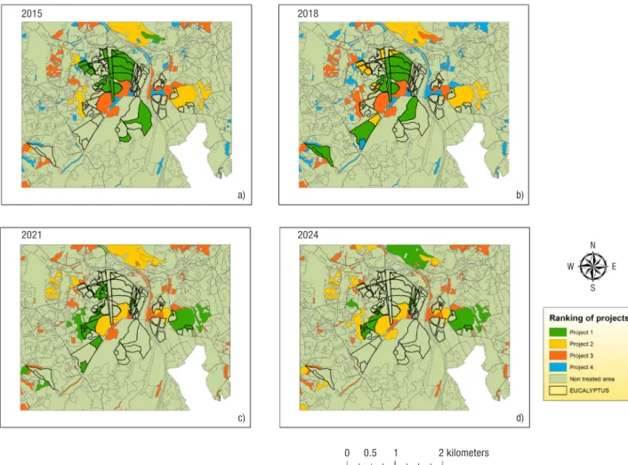
Figure 2. Ranking of projects (aggregate option) to prioritise the entire study area into a sequence of project areas. The project
labelled with numbers from 1 to 4 represent respectively the highest to lowest priority planning area for the given objective. Areas labelled as “do treat” were selected for treatment based on the expected flame length and rate of spread exceeding the threshold; the other areas are within the project areas but were not selected for treatment.
2015 a) c) b) d) 0 0.5 1 2 kilometers 2021 2018 2024 N S E W
to examine temporal changes in plantations we were able to add a temporal analyses to the strategic imple-mentation of fuel management. This temporal aspect was made possible by pre-existing research that led to the development of growth and yield model, canopy equations and fuel models descriptions.
Given the fire risk and cost of performing forest and shrublands fuel treatments across large areas, effective allocation of resources is critical. It is very challenging to strategically select fuel treatment locations on space and time with heterogeneous landscape i.e., topography, fuel models, and highly valuables resources susceptible to potential fire damages (Wei & Long, 2014). In this sense, we demonstrated a new approach for prioritising forest management through time in eucalypt stands in Serra do Socorro.
The framework of our method joined models of forest stand dynamics with optimisation models to provide a new decision support system for locating areas for fuel treatments. The study demonstrates new ways to develop efficient risk mitigation practices focusing on spatial-time-investment fuel treatment The specific fuel treatments, including slash removal
and prescribed burning would be carried out in these areas according to local conditions to modify fuel structure and fuel load changes. In our study area, prescribed burning as fuel management is the treatment preferred for the removal of accumulated fuel loads in blue gum plantations (i.e., after stool selection) (Pinto
et al., 2013). Other punctual operations depending on
the stand status might include mechanical treatments used separately or in concert with prescribed fire to reduce fuel loads and alter fuel structure and thus minimise fire impacts (Fernandes et al., 2011). Never-theless, several studies suggest that the final size of individual fires can be impacted by landscape treatment rates as low as 5% (e.g. Cochrane et al., 2012).
contribution to fire-management strategies
The methods we used can potentially have wider application to explore fuel and fire management options in eucalypt plantations. By coupling FlamMap and LTD
Figure 3. Ranking of projects (non-aggregate option) to prioritise the entire study area into a sequence of project areas. The project
labelled with numbers from 1 to 4 represent respectively the highest to lowest priority planning area for the given objective.
2015 a) c) b) d) 0 0.5 1 2 kilometers 2021 2018 2024 N S E W
acknowledgements
The study was framed under the thesis work of the Erasmus Mundus master MEDfOR - Mediterranean Forestry and Natural Resources Management (2013/2015). We gratefully acknowledge Dr. Paulo Fernandes (Universidade de Trás-os-Montes e Alto Douro) and Dr. Margarida Tomé (Universidade de Lisboa) for comments on an earlier version of the manusctript, Dr. Paula Soares for the use of the soft-ware Globulus to model the time-line growth of the inventory plots, and The Navigator Company for sup-plying the inventory databases and support in field visits and Filipa Araújo from the Camara Municipal de Torres Vedras for the spatial dataset.
References
Agee JK, Skinner CN, 2005. Basic principles of forest fuel reduction treatments. Forest Ecol Manag 211(1-2): 83–96. http://dx.doi.org/10.1016/j.foreco.2005.01.034.
Ager A, Vaillant N, Finney M, 2010. A comparison of land-scape fuel treatment strategies to mitigate wildland fire risk in the urban interface and preserve old forest
struc-ture. Forest Ecol Manag 259: 1556–1570. http://dx.doi.
org/10.1016/j.foreco.2010.01.032.
Ager A, Vaillant N, Finney M, 2011. Integrating Fire Behav-ior Models and Geospatial Analysis for Wildland Fire Risk Assessment and Fuel Management Planning. J
Combus-tion 2011: 1–19. http://dx.doi.org/10.1155/2011/572452.
Ager AA, Vaillant NM, Owens DE, Brittain S, Hamann J, 2012. Overview and example application of the Landscape Treatment Designer. Gen. Tech. Rep. PNW-GTR-859, USDA Forest Service, Pacific Northwest Research Station, Portland, OR.
Ager AA, Vaillant NM, McMahan A, 2013. Restoration of fire in managed forests: a model to prioritize landscapes
and analyze tradeoffs. Ecosphere 4: 29. http://dx.doi.
org/10.1890/ES13-00007.1.
Ager AA, Day MA, McHugh CW, Short K, Gilbertson-Day J, Finney MA, Calkin DE, 2014a. Wildfire exposure and fuel management on western US national forests. J.
En-viron Manag 145: 54-70. http://dx.doi.org/10.1016/j.
jenvman.2014.05.035.
Ager AA, Day MA, Finney MA, Vance-Borland K, Vaillant NM, 2014b. Analyzing the transmission of wildfire expo-sure on a fire-prone landscape in Oregon, USA. Forest
Ecol Manag 334: 377-390. http://dx.doi.org/10.1016/j.
foreco.2014.09.017.
Alexander ME, Cruz MG, 2013. Are the applications of wildland fire behaviour models getting ahead of their
evaluation again? Environ Modell Softw 41: 65- 71. http://
dx.doi.org/10.1016/j.envsoft.2012.11.001.
Botequim B, Garcia-Gonzalo J, Marques S, Ricardo A, Borges JG, Tomé M, Oliveira MM, 2013. Developing
strategies in fire-prone landscape. The simulation methods also provide a way to communicate wildfire risk to the diverse array of landowners and other stakeholders in Serra do Socorro and adjacent areas in Central Portugal. Thus the methodology can be implemented as part of operational-planning decision-making and helps efficient forest management when answering spatial-temporal question such as where and when fuel treatments are required under the de-sired objectives.
The literature provides little guidance for determining the required fire behaviour knowledge (e.g. the use of crown fire models developed for conifers and the spot-ting potential of eucalypts) for an effective protection of eucalypt plantations (Fernandes et al., 2011). Indeed, the limitations of simulation models has been suggested by several authors (Alexander & Cruz, 2013; Cruz & Alexander, 2010). A large number of observations ob-tained from carrying out experimental simulations stud-ies (e.g. FlamMap5) showed that, in many cases, they are instrumental to predict fire behaviour characteristics and can quantitatively replicate large wildfire events, in terms of predicted burned area (Finney et al., 2011), and size and shape of perimeters (Ager et al., 2014a; Salis
et al., 2014). Wildfire simulations should be regarded as
general indicators of wildfire exposure and fuel manage-ment planning for prioritising fire protection efforts (Salis et al., 2013). We attempted to minmise errors with the application of FlamMap by using calibrated fuel models for the study area (Fernandes et al., 2009). We acknowledge that even if the strategic location of fuel treatments projects are in line with local manager expe-riences and silviculture practices, uncertainties in the the fuel model and weather data input (i.e., wind conditions) contribute to variability in our modeled outputs (Ol-iveira et al., 2016).
In future work we will conduct sensitivity analyses to test a wide range of scenarios that vary in terms of intensity of area treated (hectares). We also suggest that future studies include social and demographic factors since these play a role in Serra do Socorro fire regime as evidenced by the strong links between population and agricultural activities and the common use of fire irre-spective of season (Raínha & Fernandes, 2002). Cou-pling mitigation efforts for both social and biophysical risk factors in terms of human ignitions and fuel manage-ment is likely the most efficient mitigation strategy for wildfire risk management in fire prone eucalypt planta-tions in Portugal. Moreover, a better understanding of wildfire risk transmission between eucalypt plantations and surrounding communities (Ager et al., 2014b; Haas
et al., 2015; Oliveira et al., 2016) will facilitate the
de-velopment of strategic fuel treatment plans aimed at reducing future wildfire impacts.
Finney MA, 2006. An Overview of FlamMap Fire Modeling Capabilities. In Fuel Management-How to Measure Suc-cess: Conference Proceedings RMRS-P-41. 28-30 March, Portland, Oregon. pp. 213–220.
Finney MA, Seli RC, Mchugh CW, Ager AA, Bahro B, Agee JK, 2006. Simulation of Long-Term Landscape-Level Fuel Treatment Effects on Large Wildfires. In USDA Forest Service Proceeding RMRS-P-41, pp. 125–147.
Finney MA, Grenfell IC, McHugh CW, Seli RC, Trethewey D, Stratton RD, Brittain S, 2011. A method for ensemble wildland fire simulation. Environ Model Assess 16:
153-167. http://dx.doi.org/10.1007/s10666-010-9241-3.
Gabinete Técnico Florestal, 2015. Plano Municipal de Def-esa da Floresta Contra Incêndios (PMDFCI) 2015-2019. Forest Fires Municipal Plan in Torres Vedras, 2015-2019.
http://www.cm-tvedras.pt/assets/upload/documen-tos/2015/10/05/pmdfci_torres_vedras_2015_2019.pdf.
Haas JR, Calkin DE, Thompson MP, 2015. Wildfire risk trans-mission in the Colorado Front Range, USA Risk Analysis
35(2): 226–240. http://dx.doi.org/10.1111/risa.12270.
ICNF, 2013. IFN6 - Áreas dos usos do solo e das espécies florestais de Portugal continental. Instituto da Con-servação da Natureza e das Florestas, Lisboa, Portugal, pp. 34.
Kalabokidis K, Palaiologou P, Finney M, 2013. Fire Behav-ior Simulation in Mediterranean Forests Using the Mini-mum Travel Time Algorithm. In Proceeding of 4th Fire Behavior and Fuel Conference (p. 25). Missoula, Montana, USA: Internat Ass Wildland Fire.
Marques S, Garcia-Gonzalo J, Borges JG, Botequim B, Ol-iveira MM, Tomé J, Tomé M, 2011. Developing post-fire
Eucalyptus globulus Labill stand damage and tree
mortal-ity models for enhanced forest planning in Portugal. Silva
Fenn 45(1): 69-83. http://dx.doi.org/10.14214/sf.32.
Marques AL, Pacheco AP, Claro J, Oliveira TM, 2014. FIRE-ENGINE, from empirical studies to system design and policy. A cohesive tool set: aplicação ao município de Torres Vedras. p. 142.
Mateus P, Fernandes PM, 2014, Forest Fires in Portugal: Dynamics, Causes and Policies. In: Reboredo, F. Forest Context and Policies in Portugal, Present and Future Chal-lenges. World Forests, Vol.19. Springer. Pp: 219-236. Oliveira TM, Barros AM, Ager A, Fernandes P, 2016.
As-sessing the effect of a fuel break network to reduce burnt area and wildfire risk transmission, Int J Wildfire Fire
25(6): 619-632. http://dx.doi.org/10.1071/WF15146.
Pereira MG, Aranha, J, Amraoui M, 2014. Land cover fire proneness in Europe. Forest Systems, 23(3): 598–610. http://dx.doi.org/10.5424/fs/2014233-06115.
Pinto A, Fernandes PM, Espinosa-Prieto J, Loureiro C, 2013. FIREglobulus: Experimental Study of Fire Behaviour and Effects in Blue Gum Plantations. Silva Lusitana 21, Junho.
Raínha M, Fernandes, PM, 2002. Using the Canadian Fire Weather Index (FWI) in the Natural Park of Montesinho, NE Portugal: calibration and application to fire manage-ment.
Salis M, Ager AA, Arca B, Bacciu V, Duce P, Spano D, 2013. Assessing exposure of human and ecological values to wildfire risk probability models for Eucalyptus globulus
stands in Portugal. iForest 6: 217-227.
Bradstock RA, Cary GJ, Davies I, Lindenmayer DB, Price OF, Williams RJ, 2012. Wildfires, fuel treatment and risk mitigation in Australian eucalypt forests: insights from landscape-scale simulation. J Environ Manag 105: 66–75. http://dx.doi.org/10.1016/j.jenvman.2012.03.050. Cochrane M, Moran C, Wimberly M, Baer A, Finney M,
Beckendorf K, Eidenshink J, Zhu Z, 2012. Estimation of wildfire size and risk changes due to fuels treatments. Int
J Wildland Fire 21: 357-367. http://dx.doi.org/10.1071/
WF11079.
Cruz MG, 2005. Guia fotográfico para identificação de com-bustíveis florestais Região Centro Portugal. Centro de Estudos sobre Incêndios Florestais. (p. 38). ADAI, Coim-bra, Portugal.
Cruz MG, Viegas DX, 1998. Crown fuel dynamics in blue-gum eucalyptus (Eucalyptus globulus Labill.) plantations fuel complex: Implications on extreme fire behavior phenomena. In Proceeding of 3rd International Conference on Forest Fire Research-14th Conference on Fire and For-est Meteorology, Luso-Coimbra, Portugal.16/20 Novem-ber, pp. 2089–2109.
Cruz MG, Alexander ME, 2010. Assessing crown fire poten-tial in coniferous forests of western North America: a critique of current approaches and recent simulation
stud-ies. Int J Wildland Fire 19: 377-398. http://dx.doi.
org/10.1071/WF08132.
Duncker P, Barreiro S, Hengeveld GM, Lind T, Mason WL, Ambrozy S, Spiecker H 2012. Classification of forest management approaches: a new methodological frame-work and its applicability to Europan forestry. Ecology
Society 17(4): 51.
http://dx.doi.org/10.5751/ES-05262-170451.
Ellis PF, 2000. The Aerodynamic and Combustion
Charac-teristics of eucalypt bark. A Firebrand study.
https://digi-talcollections.anu.edu.au/handle/1885/49422.
Fernandes P, 2009. Combining forest structure data and fuel modelling to classify fire hazard in Portugal. Ann For Sci
66 (415). http://dx.doi.org/10.1051/forest/2009013.
Fernandes P, Gonçalves H, Loureiro C, Fernandes M, Costa T, Cruz MG, Botelho H, 2009. Modelos de Com-bustível Florestal para Portugal. In Actas do 6o Con-gresso Florestal Nacional. SPCF, Lisboa, Portugal. pp. 348–354.
Fernandes PM, Loureiro C, Palheiro P, Vale-Gonçalves H, Fernandes M.M, Cruz MG, 2011. Fuels and fire hazard in blue gum (Eucalyptus globulus) stands in Portugal. Boletín del CIDEU 10: 53-61.
Fernandes PM, 2015. Empirical Support for the Use of Pre-scribed Burning as a Fuel Treatment. Current Forestry
Reports 1(2): 118-127.
http://dx.doi.org/10.1007/s40725-015-0010-z.
Ferreira L, Constantino MF, Borges G, Garcia-Gonzalo J, 2012. A Stochastic Dynamic Programming Approach to Optimize Short- Rotation Coppice Systems Management Scheduling : An Application to Eucalypt Plantations under Wildfire Risk in Portugal. Forest Science 58(4): 353–365. http://dx.doi.org/10.5849/forsci.10-084.
Stratton RD, 2006. Guidance on Spatial Wildland Fire Analysis : Models, Tools, and Techniques. Gen. Tech. Rep. RMRS-GTR-183. Fort Collins, CO: U.S. Department of Agriculture, Forest Service, Rocky Mountain Research Station.
Tomé M, Oliveira T, Soares P, 2006. O modelo GLOBULUS 3. 0 dados e equações (p. 23). Universidade Técnica de Lisboa - Instituto Superior de Agronomia Departamento de Engenharia Florestal (Portugal).
Van Wagner CE, 1977. Conditions for the start and spread
of crown fire. Can J For Res 7: 23-34. http://dx.doi.
org/10.1139/x77-004.
Vogler, KC, Ager AA, Day MA, Jennings M, Bailey JD, 2015. Prioritization of forest restoration projects: tradeoffs between wildfire protection, ecological restoration and
economic objectives. Forests, 6(12): 4403-4420. http://
dx.doi.org/10.3390/f6124375.
Wei Y, Long Y, 2014. Schedule fuel treatments to fragment high fire hazard fuel patches. MCFNS, 6(1): 1–10. wildfire in Sardinia, Italy. Int J Wildland Fire 22: 549–565.
http://dx.doi.org/10.1071/WF11060.
Salis M, Ager A, Finney M, Alcasena F, Arca B, Munoz O, Santoni P, Spano D, 2014. Application of simulation mod-eling for wildfire risk assessment and management. In VII International Conference on Forest Fire Research. (Ed. D
Viegas). http://dx.doi.org/10.14195/978-989-26-0884-6_181.
Scott JH, Reinhardt ED, 2001. Assessing crown fire potential by linking models of surface and crown fire behavior. Research Paper RMRS–29. USDA Forest Service, Rocky Mountain Research Station, Fort Collins, Colorado, USA, p. 59.
Soares P, Tomé M, 2001. A tree crown ratio predicion equa-tion for eucalypt plantaequa-tions. Ann For Sci 58(2): 193-202. http://dx.doi.org/10.1051/forest:2001118.
Soares P, Tomé M, Pereira JS, 2007. A produtividade do eucaliptal. In: Alves, A.M., Pereira, J.S., Silva, J.M.N. (Eds.), O Eucaliptal em Portugal – Impactes Ambientais e Investigação Científica. ISAPress, Lisbon, pp. 27–60.