U
NIVERSIDADE DE
L
ISBOA
Faculdade de Ciências
Departamento de Informática
UCAT
UBIQUITOUS CONTEXT AWARENESS
TOOLS FOR THE BLIND
Ivo Rafael Pereira Rodrigues
DISSERTAÇÃO
MESTRADO EM ENGENHARIA INFORMÁTICA
Especialização em Sistemas de Informação
U
NIVERSIDADE DE
L
ISBOA
Faculdade de Ciências
Departamento de Informática
UCAT
UBIQUITOUS CONTEXT AWARENESS
TOOLS FOR THE BLIND
Ivo Rafael Pereira Rodrigues
DISSERTAÇÃO
Trabalho orientado pelo Prof. Doutor Tiago Guerreiro
MESTRADO EM ENGENHARIA INFORMÁTICA
Especialização em Sistemas de Informação
v
Acknowledgements
I would like to thank first and foremost my thesis adviser professor Tiago Guerreiro for accepting to be my mentor for this thesis and enduring with me throughout the year as well as professor Luis Carriço for accepting me and guiding me through the thesis with invaluable input. A mention to Luis Duarte also for the help provided discussing ideas and providing input whenever it was needed.
My family for providing me with the platform and the ability to be able to do this work and have my master degree, without family we can only go so far in life.
Colleagues that through the year shared the journey and always provided a source of knowledge and information when debating the project as well as the much needed moments to clear my head and calm down for a bit when needed.
A thank you also for the FCUL for being a great place to study and grow both on a personal and academic level, the Lasige group who welcomed me during my thesis in particular the Absinth group which provided with, in my opinion, one of the best interactions and participation they could have possibly give for someone who is working on a thesis.
Last but not least friends. These are always the pillars of our stability the people we look for when we need anything, and they were always there whenever I needed them.
vii
Resumo
As pessoas com deficiências visuais sofrem de uma constante falta de informação sobre o ambiente que as rodeia. Esta informação pode estar relacionada com locais, objetos e até mesmo pessoas. A inexistência de ajuda para combater esta falta de informação faz com que surjam situações em que uma pessoa cega só consegue resolver o seu problema recorrendo a ajuda de outras pessoas. São exemplos a identificação da presença de pessoas, informação escrita o e outros detalhes de uma rotina diária. Os dispositivos móveis dos dias de hoje vêm equipados com uma grande extensão de sensores que possibilitam colmatar algumas destas falhas.
Uma pessoa normovisual está habituada a recorrer à visão para obter informação sobre o ambiente que a rodeia. Sem grande esforço pode obter informação sobre proximidade de pessoas ou a sua movimentação. A mesma facilidade ocorre em reconhecer objetos ou orientar-se e compreender os locais onde se encontra. Esta informação é algo que pessoas cegas têm dificuldade em obter.
Situações normais como identificar quem são as pessoas que os rodeiam torna-se uma tarefa mais complicada especialmente se estas não seguirem as regras de etiqueta social e fizerem notar a sua presença. A acessibilidade nos dispositivos móveis é uma área que ainda está a ser explorada e existem diversas possibilidades de uso que estes dispositivos permitem que ainda não são acessíveis para pessoas cegas.
Cada vez mais os dispositivos móveis, em particular desde a chegada do iPhone, fornece a utilizadores cegos a possibilidade de acederem aplicações sociais, de lazer e de produtividade. Outros sistemas operativos e dispositivos seguem pelo mesmo caminho. O conjunto de características disponibilizadas por estes dispositivos nomeadamente para a localização, comunicação, armazenamento e processamento permitem criar ferramentas de perceção do ambiente para cegos cada vez mais ricas. Existem diversos trabalhos realizados para melhorar a orientação, localização, reconhecimento de objectos e proximidade (na maioria dos casos a obstáculos). Muitos deles focam-se em ambientes interiores, outros em ambientes exteriores. Uns em objects, outros têm uma componente maos social. O problema de todos estes projectos é que nenhum deles oferece uma solução complete e acessivel para pessoas cegas. As falhas existentes em cada um destes projectos deixa em aberto a possibilidade para que
viii
fosse desenvolvido um Sistema que não só junta-se todas as caracteristicas de awareness que pudessem ajudar uma pessoa cega mas também tornar este Sistema acessivel.
No entanto mesmo com tantas aplicações e projectos existe uma falha no que toca a ferramentas que tratem de perceção implícita, que forneça informação sobre o ambiente que nos rodeia dentro de contexto. O nosso projeto focou-se em identificar as necessidades de informação de uma pessoa cega no que diz respeito à falta de informação.
Foi realizada uma entrevista preliminar para que pudéssemos perceber as limitações e as necessidades que as pessoas cegas enfrentam quando confrontadas com ambientes sociais. A entrevista tinha como foco um perfil básico dos utilizadores e questões sobre o seu uso da tecnologia utilizada no projeto assim como questões sobre cenários onde a perceção do ambiente é limitada.
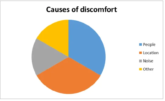
A grande maioria da entrevista focou-se em questões sobre perceção, particularmente tendo em atenção a orientação em ambientes novos e ambientes já conhecidos, as dificuldades que normalmente encontram em situações sociais e de que maneira ou que comportamentos desenvolveram para tentar facilitar o seu dia-a-dia. Tentamos perceber quais as maiores fontes de desconforto que estão habituados a enfrentar e quais delas é que causam mais transtorno.
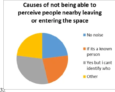
A primeira causa apontada como fonte de desconforto foi a falta de conhecimento das pessoas que os rodeiam, tanto saber quem são como quantas pessoas são. Também fizemos a questão sobre o quão fácil é para eles ter a perceção de quem os rodeia, se é uma tarefa fácil de realizar e especialmente se tinham dificuldade em perceber a entrada e saída de pessoas no seu espaço.
Todos os participantes afirmaram que seria bom obter mais informação sobre o ambiente que os rodeia, apesar de apontarem que esta ferramenta deveria passar despercebida e ser subtil na sua tarefa.
Após analisarmos os resultados das entrevistas e de termos em conta os cenários mencionados pelos utilizadores assim como os cenários que tínhamos pensado para a implementação do sistema foi desenvolvido um sistema com a intenção de explorar estes novos cenários e fazer uma avaliação mais completa da aplicação e os seus benefícios.
ix
Após a implementação do sistema este foi submetido a uma fase de avaliação que durou uma semana e meia efetuada com utilizadores cegos para que pudéssemos tirar resultados não só do resultado da implementação do sistema mas do seu impacto para um utilizador cego.
Sobre este Sistema foi feita uma avaliação de uma semana e meia, efectuada com utilizadores cegos durante a qual eles tiveram a oportunidade de explorer as capacidades do Sistema e utilizar durante o seu dia a dia normal a aplicaçao e retirar o máximo que conseguissem. Foi uma avaliação sem guião, logo os utilizadores não tinham tarefas explicitas apenas tinham que utilizar o Sistema à sua conveniencia. Durante esse period de avaliaçao os utilizadores deram-nos feedback diário de como se estava a comportar o Sistema para que pudessemos obter dados de uso diário. Foi também efectuado no final da avaliação questionários e uma entrevista final para recolher todas as informaçoes possiveis por parte dos utilizadores que fizeram parte da avaliação. Analisamos esses dados e retirámos algumas conclusões.
No geral os utilizadores estiveram satisfeitos com a informação produzida pela aplicação, foi de facto um aumento, na grande maioria dos casos, aquilo a que estão normalmente habituados. Sempre que eram notificados sentiram necessidade de explorar a notificação e perceber melhor qual a informação que a aplicação lhes estava a tentar fornecer.
Verificou-se o interesse por parte dos participantes quando estes tentavam procurar por pessoas novas implicitamente.
Todos os participantes confirmaram que o conhecimento sobre o ambiente que os rodeava foi de facto enriquecido. Houve mais facilidade em identificar pessoas quando estas chegavam a um local.
Nos últimos anos tem sido feito um esforço para aumentar a acessibilidade a dispositivos e à informação disponível nestes (Ex: através de leitores de ecrã). No entanto, o mundo real apresenta muita informação que é oferecida de forma visualmente que é assim inacessível a uma pessoa cega. Esta é uma limitação a ter em consideração que pode ajudar à interação social e a compreensão do ambiente que rodeia o utilizador. Não existem sistemas que sejam capazes de fornecer a uma pessoa cega informação tão simples como quem é que se encontra à sua volta, quem é que passou próximo de si, quem é que ainda se encontra numa sala, quais as lojas mais próximas de si ou restaurantes ou simplesmente o que está escrito no placard de notícias. Da mesma
x
maneira, existe a falta de ferramentas que lhes permitam adicionar a sua própria informação a ambientes, que possam partilhar essa informação e servirem-se dela para se entreajudarem em situações mais complicadas.
Mostramos estas limitações, necessidades e desejos das pessoas cegas em obter informação sobre o ambiente que as rodeia. Tentando dar o enfâse no aspeto social da ferramenta, focámo-nos muito nas pessoas e na necessidade pessoal de cada individuo
xii
Abstract
Visually impaired people are often confronted with new environments and they find themselves face to face with an innumerous amount of difficulties when facing these environments. Having to surpass and deal with these difficulties that arise with their condition is something that we can help diminish. They are one sense down when trying to understand their surrounding environments and gather information about what is happening around them. It is difficult for blind people to be comfortable in places where they can’t achieve a proper perception of the environment, considering the difficulty to understand where they are, where are the things they want, who are the people around them, what is around them and how to safely get somewhere or accomplish a particular task.
Nowadays, mobile devices present significant computing and technological capacity which has been increasing to the point where it is very common for most people to have access to a device with Bluetooth, GPS, Wi-Fi, and both high processing and storage capacities. This allows us to think of applications that can do so much to help people with difficulties. In the particular case of blind people, the lack of visual information can be bypassed with other contextual information retrieved by their own personal devices.
Mobile devices are ubiquitous and are able to be used virtually anywhere and allow connectivity with one another. This also allows their users to save information and convey it through several devices, which means that we can easily share data, augmenting our possibilities beyond what a single device can do.
Our goal is to provide information to blind users, be able to give them information about the context that surrounds them. We wanted to provide the blind users with the tools to create information and be able to share this information between each other, information about people, locations or objects. Our approach was to split the project into a data and information gathering phase where we did our field search and interviewed and elaborated on how is the situation of environment perception for blind users, followed by a technical phase where we implement a system based on the first stage. Our results gathered from both the collecting phase and our implementing phase showed that there is potential to use these tools in the blind community and that they welcome the possibilities and horizons that it opens them.
xiv
Content
Acknowledgements ... v
List of Figures ... xvii
List of tables ... xviii
Chapter 1 - Introduction ... 1 1.1 - Motivation ... 1 1.2 - Awareness Tools ... 3 1.3 - Contributions ... 4 1.4 - Publications ... 5 1.5 - Document Structure ... 6
Chapter 2 - Related Work ... 7
2.1 - Awareness Systems ... 7
2.1.1 - Location Related Systems ... 8
2.1.2 - Object Related Systems ... 10
2.1.3 Social Related Systems ... 12
2.2 – Discussion of Awareness Systems ... 13
2.3 – Supporting Technologies ... 15
2.3.1. - Global Positioning System (GPS) ... 15
2.3.2 - Bluetooth ... 16
2.3.3 - RFID ... 17
2.3.4 - Ultrasound ... 18
2.3.5 – Infrared ... 19
2.3.6 - WLAN ... 19
2.4 Discussion about technologies ... 20
Chapter 3 - Approach: Ubiquitous Awareness Tools for Blind People ... 23
3.1 - Evaluation Methodology ... 24 3.2 - Participants ... 26 3.3 - Material ... 26 3.4 - Procedure ... 26 3.5 - Results ... 27 3.6.1 - Pre-Questionnaires ... 27 3.6.2 - User Profiles ... 27
xv
3.6.3 -Awareness ... 30
3.7 –Proof of concept prototype ... 34
3.7.1 - Usage ... 37 3.7.2 - User Opinions ... 37 3.7.3 - Post-Test Brainstorming ... 38 3.7.4 – Post-test Interviews ... 38 3.7.5 - Group discussion ... 39 3.8 - Discussion ... 40 3.8.1 - Major Challenges ... 40 3.8.2 – Scenarios ... 41
3.8.2.1 – Associating notes and reminders with outdoor locations ... 41
3.8.2.2 – Associating notes and reminders with contacts ... 42
3.8.2.3 – Notification associated with a friendly contact through a third person . 42 3.8.2.4 – Recognizing people in the surroundings and their information ... 42
3.8.2.5 – Navigation notifications related to location ... 43
3.8.2.6 – Notification associated with time, space and users (all at once) ... 43
3.9 – Conclusions ... 43
Chapter 4 – System Implementation ... 45
4.1– System Architecture ... 46
4.1.1 Google Cloud Messaging (GCM) ... 47
4.1.2 – System Database ... 47
4.2 - Communication and synchronization ... 49
4.3 – User Interface ... 51
4.3.1 - Navigation ... 51
4.3.2 Creating a note (Input Writing text) ... 51
4.3.3- Feedback ... 52 4.3.3.1 -Vibration ... 52 4.3.3.2- Audio ... 53 4.3.4- Menus ... 53 Chapter 5 –Evaluation ... 54 5.1 - Introduction ... 54 5.2- Evaluation Method ... 56
xvi 5.2.2 – Participants ... 56 5.2 .3 - Procedures ... 57 5.3 - Results ... 58 5.3.3 – Data analysis ... 59 5.3.3.1 – Analysis of usage ... 60
5.3.3.2– Detection Results Logs ... 61
5.5 Discussion ... 67
6 - Conclusions ... 70
6.1 – Limitations ... 70
6.2 – Future Work ... 71
xvii
List of Figures
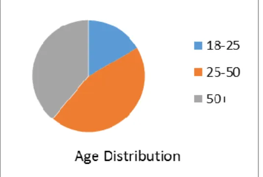
Figure 1- Pie chart of Age distribution of participants………29
Figure 2 - Touchscreen usage………..…29
Figure 3 - Difficulties using touchscreen………29
Figure 4- Causes of discomfort on a environment………..31
Figure 5 - Perception of people movements………32
Figure 6 - Causes of lack of perception on people………..32
Figure 7 - What they use as reminders/notes………...33
Figure 8 - Note creation...……..35
Figure 9 - Initial screen………35
Figure 10 – Notes……….36
Figure 11 – Contact Menu………36
Figure 12 System Architecture……….46
Figure 13 - Communication overview………..50
xviii
List of tables
Table 1 Comparison of awareness systems………..14
Table 2 Active vs Passive RFID ………..18
Table 3 Table of comparison of technologies ……….22
Table 4 User pool technological profiles……….28
Table 5 - Usage of features from the cellphone……….29
1
Chapter 1 - Introduction
1.1 - Motivation
The number of people with visual disabilities worldwide is around 135 million, of which 45 million are blind1. This amounts to a significant number of people whose lives are affected by other millions of simple, but at the same time impairing problems due to their condition.
Blind people have a significantly higher difficulty in exploring and being able to know their surroundings, both in indoor and outdoor environments [10]. These difficulties deter and sometimes force blind people from doing some activities they would otherwise enjoy doing or would like to do.
It is common for people to have to go through several places both indoor and outdoor on a daily basis. From their own homes to the work place, public places, street and even recreational spaces. This is no exception for the blind. – However, in their case, the level of comfort or how easy they can orient themselves in these places is much different. For instance, when they move into a hometown, a work place or a school, these people will have difficulties getting to where they want, having a perception of their environment and how to freely do what they want. This is hard already even when they are used to the places, now think about new environments, getting to know these comes with a higher degree of difficulty then usual to them and it even requires them to learn specific information about the environment that non-visually impaired people are not aware of. This knowledge is what they need in order to make their interaction in this environment easier. Due to the fact that we are used to seeing we don’t usually take into consideration the kind of information that visually impaired people need to have to be comfortable in a new environment. We thought about how visually impaired people adapt and adjust to a environments especially an indoor environment and we realized
1 Unite for Sight, World Health Organization report, http://www.uniteforsight.org/eye_stats.php),
2
that they could not understand when message boards, specific locations (specifically in new places) or even other people had some information that could benefit them or help them. In a world where so much of what we do is dictated by how much we know of what surrounds us, visually impaired people face a great disadvantage that can be improved by trying to provide not only information that non impaired users are used to receive through vision but also provide them with the kind of specialized information that they need because of their condition and also any kind of information that even sighted users get from some tools that simply are not yet accessible to the blind population.
The past decade had several technological advances that have made possible the proliferation of personal location technology in portable devices (Smartphones, Tables). Smartphone sales showed strong growth worldwide in 2011. Here are some numbers from several sources2, report from IDC, (February 2012), says the shipments in 2011 were 491.4 million units up 61.3 percent from 2010. This makes smartphones 31.8 percent of all handsets shipped. Report from Strategy Analytics (February 2012) claims total shipments in 2011 were 488.5 million units up 63.1 percent from 2010. This makes smartphones 31.5 percent of all handsets shipped. Also Gartner (February 2012) reports a total of smartphone sales in 2011 reached 472 million units up 58 percent from 2010. This makes smartphones 31 percent of all handsets shipped. The last IDC report (June 2012) predicts that 686 million smartphones will be sold in 2012, 38.4 percent of all handsets shipped. According to IDC, smart phones accounted for 36 percent of global mobile-phone shipments in the first quarter of 2012, up from 25 percent a year earlier. If smart phones continue to gain at even this pace, “feature phones” will be largely a memory in another five years3. In recent years, many regular
mobile devices have screen reading software that allow blind users to be able to use them. [2]. “Touchscreen devices like the iPhone were once assumed to be inaccessible
to blind users, but well-designed, multitouch interfaces leverage the spatial layout of the screen and can even be preferred by blind people “[13].
The fact that our handheld devices are getting better connectivity options (better Wi-Fi, better Bluetooth), better computing capacity and that their proliferation is increasing
2 http://mobithinking.com/mobile-marketing-tools/latest-mobile-stats/a#smartphone-shipments
3
each year allows us to develop applications that can communicate with other devices or services allowing the trade of data and localization.
These capabilities enabled us to design and implement an application that can be introduced in the day to day life of visually impaired people, to provide a sort of a personal assistant which can perform a number of tasks to help out in the normal life of a user. It can be framed as an awareness tool we provide blind users to contribute to the supply of information they can get out of their surroundings. First of all a tool that helps blind users identify and be aware of the presence of other people in their surroundings. A context awareness tool that allows for a wide array of usage, with an embedded notification system which can be used to trade information between users and serve as a data storage, from a social perspective for simple message trading, for work related such as appointments, informational notifications for navigation where the application helps users be more comfortable in new surroundings by knowing where they are and by having access to all sort of helpful information, all this associating people, location or time to these notifications.
A big concern is to be able to provide all this in an accessible way for visually impaired people. We wanted to leave behind, after our work, a set of foundations to what these applications can and should do for visually impaired users. Identifying the important information, the good scenarios where users need the most help and would like to get the most help.
1.2 - Awareness Tools
The goal of this dissertation is to create a complete system that can provide information regarding objects, people and locations both indoors and outdoors - a tool to provide information about the surrounding of a person. This tool is to be usable by visually impaired people to allow them to have further knowledge about their surroundings. Concretely, we wanted to achieve a functional and practical application which allows blind users to use it has a tool to navigate new environments, to enable them to be more aware of their surroundings and finally be able to use it to trade notifications in a unique way between users using not only physical locations to tag notifications but also people. The first step we did was to identify through some questionnaires, interview and brainstorming sessions together with our blind participants what should be our main
4
focus when considering what awareness we could provide for a blind person. After we got some results from the data we collected over the interviewing of our blind participants we focused on developing a first prototype to test our findings. We developed a prototype capable of tagging users. This first prototype is able to identify people and associate information with them. This prototype takes into account proximity and is usable both indoors and outdoors. After this the goal is to add the possibility to create information associated with locations and objects. Finally we want to allow blind users to share this information between each other.
The system comprised both outdoor and indoor locations which is something that most applications lack. Most systems focus only on the outside since the indoor ones are much more complex than the simple usage of the GPS coordinates provided for outdoors locations.
Notification systems are usually associated with locations and in some cases they also use time as a parameter, however there is much less work done regarding identifying people specifically and tagging people instead of locations. For the visually impaired there is also the fact that anything that is usually used as a visual note, message board, posters, televisions are not easily perceived, even message boards with braille make them search the board for anything new as they do not know immediately what is being displayed to them.
The applications existing nowadays try and tackle these situations one by one and they do not offer a solution that envisions a complete system that works both outdoors and indoors. Also most of these do not even include a notification system to allow users to trade information between one another.
There is a lot of work done in this area regarding tagging locations mostly on outdoor environments and some work done in indoor environments however there is still a lack in the tagging of individual users instead of places. It is harder to deal with the user position directly because they are usually in movement and so identifying them is a complex problem.
1.3 - Contributions
Our main contribution was focused on answering the question if awareness systems can be used to help blind users. And provide information about how to properly implement such a system. During the duration of the project we had the following contributions.
5
A State of the art review on awareness tools for blind people aiming to provide context both explicitly and implicitly.
An in-depth analysis of the limitations and needs of blind people in context-challenging environments. This analysis spanned novel and known spaces, both indoor and outdoor and an overview of their day to day in these environments.
A distributed mobile prototype able to provide awareness about people and specific locations. This system also allowed users to generate information and save it in the form of notes that could be shared for multiple purposes and in multiple ways.
A mobile user interface adapted to blind people’s abilities designed with a user-centered approach.
An evaluation methodology for context-aware systems in the wild.
1.4 - Publications
The contributions provided in this dissertation were accepted for publication in two peer-reviewed conferences:
Ivo Rafael, Luís Duarte, Luís Carriço, Tiago Guerreiro, “Towards
Ubiquitous Awareness Tools for Blind People”, In Proceedings of HCI
2013– The 27th International British Computer Society Human Computer Interaction Conference: The Internet of things, London, UK, September 2013.
Ivo Rafael, Luís Duarte, Luís Carriço, Tiago Guerreiro, “Ferramentas Contextuais para Pessoas Cegas”, Actas da Interação 2013 - 5ª Conferencia Nacional sobre Interação, Vila Real, Portugal, Novembro, 2013
6
1.5 - Document Structure
In chapter 2, we describe the related work done in this area and try to cover the most significant projects that involve context awareness and their positive and negative aspects. An analysis of these projects showed that there are lacking mobile systems that provide implicit and explicit context awareness. We make a breakdown of these projects and do a summary of the analysis that we took into account for the next step. This step is described in Chapter 3, where we go into detail about our first steps into figuring out what exactly the blind users need and what they expect regarding context awareness. We explore the limitations by interviewing 13 blind people and probing them with a proof-of-concept prototype able to detect people in the surrounding environment. These studies confirmed the need for awareness tools and brought new scenarios particularly in outdoor scenarios and in augmenting locations with annotated information. Chapter 4 presents the details of the implementation of this system. In particular, we depict the architecture of the system and the non-visual user interface. It is the technological chapter where we try to provide information of how someone could replicate the system anytime. The final chapter, Chapter 5, we discuss the results of our field test made with the application design presented in chapter 4. After a one week and a half field test with the final application we did a series of daily small debriefings followed by a final questionnaires and interviews that we used to collect our results and sum up our findings. We use this chapter to present our findings and what we perceive as guidelines for the development of such tools.
7
Chapter 2 - Related Work
This chapter presents a critical overview of previous work pertinent to this thesis. What we explore is the environment context for a person. The awareness of ones surrounding location. People in our presence, identifying our location, perceiving the space around us, objects, what information can be taken from an environment. Low level fragments of context information, for example, that five people are located within a few feet of coordinates (1,10,20) in a building coordinate system, that those coordinates correspond to Conference Room A, and that Conference Room A is currently scheduled for a budget meeting, may be composed to deduce higher-level information, for example, that each of those individuals is currently involved in a budget meeting.
This context information can be associated with systems that take into account location as their primary source, others are focused on objects as means to relay information to the blind user and there are also the systems that focus more on the social aspect, which are more related to the relation between people. The idea behind all these systems is that they want to provide the blind user information about different things in their surrounding using different perspectives.
The next section shows examples of these systems and how they try to help out the blind user be more aware of its surroundings and what context he is inserted into. It will also give an overview about the technologies used in these systems and compare them thru several aspects.
2.1 - Awareness Systems
Awareness systems can be broadly defined as those systems that help people construct and maintain awareness of each other’s activities, context or status. Context awareness and location awareness are concepts of large importance. The term of location awareness is still gaining momentum with the growth of ubiquitous
8
computing[24]. First defined with networked work positions, it has been extended to mobile phones and other mobile communicable entities. The term covers a common interest in the whereabouts of remote entities, especially people. “Context awareness is
defined complementary to location awareness. Whereas location may serve as a determinant for resident processes, context may be applied more flexibly with mobile computing with any moving entities, especially with bearers of smart communicators”.4
We will focus on three types of systems based on their focus about the information they try to relay, location systems, object systems and social systems.
2.1.1 - Location Related Systems
Some systems focus on location as the main focus of information, most of them are used for navigation or just orientation, which is one of the most important difficulties of blind users in new environments. Having information about locations for the blind can help them feel more comfortable about their surroundings.
2.1.1.1 - Museum Guides
This system developed by Ghiani et al [6], is a multimodal and location aware museum guide, which has been specifically designed for visually impaired people to provide them with flexible orientation support. It brings the benefits of location-aware sensing to blind users by enhancing a mobile guide with reliable orientation support. In this way blind users can access information regarding artworks or scientific specimens in their original locations, even if they cannot directly appreciate them. Such support can assist blind users both when they can touch an item on display and when it is not possible. In fact, if blind users can receive notional and (alternative) descriptive information on the artworks available, they can have a more enjoyable and informative visit. In addition, such support can enhance a blind person’s museum visit together with their family and/or friends. Thanks to such support, blind visitors can be more autonomous and socially integrated. This system is designed as an indoor location system; it makes use of RFID technology to accomplish its goals.
9
This system’s main advantage is that it works indoors which most do not, and it provides not only orientation information for the blind user but also some regarding particular objects even though it is all based on location.
2.1.1.2 – Autonomous Navigation through the City
While navigating through the city, blind people are faced with various obstacles and situations within the urban landscape. Such elements are entirely common for most people, but the situation is different for people with vision impairments. This difference that exists may be a source of fear for blind people when navigating on their own, thus affecting their mental representation of the space traveled. Currently, a verbal description of the environment provided by sighted people is the most commonly used aid for blind people to be able to navigate in open spaces, or that of an experienced blind user in the environment they are in. This largely limits safe and independent navigation by blind people both in their homes, in nearby environments and in outdoor spaces. The software presented in by Sanchez et al [22] “consists of a simple and low
cost software and hardware solution that helps blind users to navigate and carry out their daily outdoor mobility tasks in both familiar and/or unfamiliar environments”.
This tool consists of an audio based application that is integrated into a mobile device, which together with the help of GPS satellites and a GPS device, provides blind users with information in order to be able to orient themselves and navigate through various points of interest in the city.
This system is designed for the outdoor environment and allows the blind user to get information regarding their surroundings and their physical location.
The advantage is that they use audio-based GPS software. This software favors the navigation of blind people in unfamiliar contexts, since it is not a requirement that the user has already been through the route. However the software does not provide enough information to be able to detect certain obstacles in the path, such as curbs, roadwork or storefronts.
2.1.1.3 - Integrated Indoor/Outdoor Blind Navigation System
There are many systems that try and help blind people navigate thru new locations, however most of them do not work both indoors and outdoors. This project [19] uses an Original Equipment Manufacturer (OEM) ultrasound positioning system to provide precise indoor location and Differential Global Positioning System (DGPS) for the
10
outdoor location tracking. This system is capable of providing the user with the layout of the indoor facility, and gives a broad picture of what the environment is like. The user may also get distance and navigation information between destinations. Another feature implemented is that of travel safety, as the user walks around the system timely calls out obstacles. The system can also communicate with the user and answer different contextual awareness questions on demand.
The major advantage of this project is the fact that it complements itself by being able to work both outdoors and indoors which is very important. However this system is not so simple and cheap, it does not use a simple device like a smartphone or a tablet, and it requires the user to carry around extra hardware.
2.1.2 - Object Related Systems
Another type of systems seeks to provide information about objects in the user’s surroundings. This is commonly achieved by the means of object tagging or image-based detection.
2.1.2.1 - Wearable Object Detection System for the Blind
Visually impaired people are faced with the need to identify certain items in their day to day life, in order to be able to organize their activities. However this proves to be very difficult in some cases, distinguish similar objects just by touch is not an easy thing to do. RFID uses radio waves to deliver data from a tag, which stores information, to a reader, which can elaborate the information making decisions. This project [4] uses a RFID device designed as a support for the blind in searching some objects he is presented, in particular, it has been develop for searching the medicines in a cabinet at home.
The device is compact and can easily be placed inside of a glove. The device is able to provide to the blind the information stored in the scanned tags and the value of RSSI correlated to a biofeedback signal. This function can be used by the blind to reach an object, to which an RFID tag was applied, by means of an acoustic signal.
The project requires extra devices to be carried by the user which is not ideal, and has issues when multiple RFID tags are detected.
11
2.1.2.2 – Post-IT
Brown[17] describes a framework for creating context-aware applications. A stick-e document is composed of a set of stick-e notes, each resembling a HTML page. Each stick-e note consists of content, and the context in which it will be triggered. Consider a mobile user carrying a PDA equipped with location sensing hardware. The user can place a stick-e note at a physical point of interest. When the user returns to that position in the future, the stick-e note will be triggered, the user being informed of this by the PDA. A stick-e note can therefore act as the electronic equivalent of a Post-it note. Some other examples of context that could trigger a stick-e note are given: the adjacency of a person to other physical objects and when the temperature is below a certain level. The stick-e note approach offers a useful general mechanism for the creation of context-aware applications. Further work appears to be required on system aspects, that is the management of location information and the delivery of contextual information to applications.
2.1.2.3 – Color Identification for Blind People
Visually impaired people that need to know the color of some object, or to identify the object by just knowing its color, are able to do so only by asking it to another person, when this one is nearby. This application [5] allows blind people to accomplish such a task independently. This system uses image processing in order to accomplish its goal, image processing requires that the various color models be priory studied. The color information for each pixel can be specified in standard ways, and accepted through these color models. Each model is specified by a coordinate system, generally tridimensional, where each color is represented by a single point. In this work, it was possible to design and implement an application which allows determining and communicating audibly the predominant colors of an image taken by the cell-phone’s camera.
2.1.2.4 – VizWiz
VizWiz [1] is a talking application developed for smartphones that takes advantage of the web to answer visual questions in nearly real time. It is a project aimed at enabling blind people to recruit remote sighted workers to help them with visual problems. The application is used on their smartphones with a camera, they ask questions and receive
12
answers from recruited sighted users. These tools already existed for the blind but the good thing about VizWiz is that its cost is much lower. Also the fact the application is reliant on real users makes the scope of the questions it can help answer much larger. This project also created an approach to achieve low-latency responses called quikTurkit, the main idea is queuing the workers before they are needed this makes the answers come fast enabling a proper usage of the tool.
2.1.3 Social Related Systems
These systems tend to focus on the social aspect of sharing and connecting users in order to relay the information regarding their surroundings. These systems can recur to crowd sourcing in order to accomplish their goals. The good thing about these systems is that it provides the social component that blind users could use, help them communicate and have social connections much more simply. Also these systems are very lacking in the visually impaired department, most of them have no concern for accessibility while others focus on other impairments like mobility.
2.1.3.1 - Accessible Contextual Information for Urban Orientation
A number of systems have been developed to provide location-specific information about predefined landmarks for mobile users, these systems rely on static content associated with each location, and thus could not adapt to changing or emerging user needs. To address this, a handful of systems have explored the viability of allowing users to generate arbitrary annotations for physical locations. This is where this project [23] comes in, it allows for visually impaired people to generate orientation notes and share them between one another. This project takes the orientation onto another level by adding a socially maintained online database containing information about POIs. This system however is only developed for outdoor environments which makes it lacking. An urban orientation and contextual system such as this offers relevant, dynamic, and up-to-date information, the combination of which may not otherwise be accessible.
2.1.3.2 – OurWay
Accessibility maps are valuable tools for people with mobility problems navigating in the urban landscape, OurWay [9] is a project that lets users create and augment geospatial data. This user generated content provides a basis for computing satisfactory
13
routes, from one location to another, matching the user's preferences and needs. This helps reduce the cost of such systems which are usually hard to maintain and to keep updated. By adding the social component of being able to create content and share it the big question that arises with this system is the trust needed in the people creating the content.
This is a tool developed for people in wheelchairs or with a physical impairment that makes it impossible for them to use certain paths. This type of implementation has not been properly explored for the visually impaired people.
2.1.3.3 – PeopleTones
Having a tool that can report situations that are of interest to the user is a very useful thing, PeopleTones [14] is a buddy proximity system. This application can be used to help in a variety of scenarios like arranging meetings. The project tries to focus on a proximity detection algorithm, ways to reduce the noise and interference and finding new ways to share these “good to know” things in the most unobtrusive way but still effective. The user study revealed that peripheral cues are an effective, unobtrusive mechanism for notifying people of such inferences. Although haptics have often been suggested as a promising ambient delivery mechanism, sound was the preferred medium, possibly because of its higher fidelity. This is another area that is not explored for blind users, the possibility of detecting users in their proximity. Of course the method of output is one of the most important things when thinking of an application of this kind for blind users.
2.2 – Discussion of Awareness Systems
Most of these projects try to give information regarding one component while some manage to provide support for two types of information. Some of the components have not even been properly explored focusing on the visually impaired, especially the ones that concern the creation and sharing of information.
This is an overview of the projects, what they focus in and what they lack in regards to type of information/identification.
Also some of them never considered the ubiquitous scenarios and only work either indoors or outdoors which is not optimal.
14
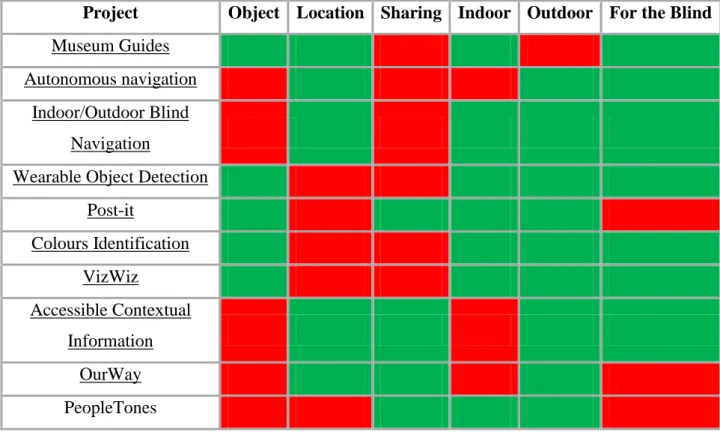
Table 1 Comparison of awareness systems
Table 1 shows a comparative evaluation of the aforementioned systems. Out of all the projects we present only half of them provided some support for object awareness and by contrast the other half presented location awareness. Only one crossed those two features and has object and location awareness. As far as sharing the information that the tool provides again only half of them have this capability. There were some projects that focused only on indoor or outdoor environments although 6 out of 4 did support at least some functionality for both type of environments. Out of all the projects mentioned not all of them were developed with accessibility taken into account, 3 out 7 do not are not blind user accessible.
Most projects are too specific when trying to tackle the problem and so never look at the overall picture as an example you have Museum Guides or Colors Identification, which
Project Object Location Sharing Indoor Outdoor For the Blind
Museum Guides Autonomous navigation
Indoor/Outdoor Blind Navigation
Wearable Object Detection Post-it Colours Identification VizWiz Accessible Contextual Information OurWay PeopleTones
15
only focus on specific problems and thus are very limited. Then we have projects that have a wider approach like VizWiz that allow for identification at multiple levels but forget about the other components like being able to create and share information or also take into account location.
2.3 – Supporting Technologies
All these applications have a similar technology base that it is used for location, object or people detection and identification. In this section we present and compare the various available technologies and their advantages and disadvantages.
2.3.1. - Global Positioning System (GPS)
GPS was conceived as a navigation system. By knowing the position of the satellites and measuring the distance between its antenna and four or more other satellites, a single GPS transmitter can compute its three dimensional speed, position and direction of travel [18].
The system is not perfect and there are errors when calculating the position, the actual position will be in a radius measuring from 20 to 100 meters. Fortunately there are ways to reduce the margin of these errors.
GPS system are commonly used for all sorts of outdoor location systems, the most common are for personal use which can be the base for all sort of applications with different objectives. Recent works done with GPS systems try to go a step further and find ways to deal with or improve the error and the uncertainty that the system
inherently has [3]. GPS can be used for Geotagging or Georeferecing in the outdoors, clock synchronization, navigation, Geocaching, etc.
Advantages:
- GPS works in all weather
- Relatively low costs (compared to other navigation systems) - Large coverage around the planet
- Accuracy has a pretty good value for its cost - Relatively easy to integrate into other technologies
16
- The system is maintained regularly by the US government (as compared to other navigations systems by other countries e.g. GLONASS)
Disadvantages:
- GPS satellite signals are weak so it doesn't work as well indoors, underwater, under trees, etc.
- The highest accuracy requires line-of-sight from the receiver to the satellite, this is why GPS doesn't work very well in an urban environment
- The United States Department of Defense can, at any given time, deny users use of the system (i.e. they degrade/shut down the satellites)
2.3.2 - Bluetooth
Bluetooth is a wireless technology through which a user can transfer data between two devices having required proximity. It has now become one of the handiest developments in the wireless technology ground which is now being used for multiple purposes and in a good range of devices for e.g.: cell phones, laptops, headset devices, video game consoles, printers, tablets, music players and HD TV’s. There is also an upcoming innovation to the Bluetooth Protocol coming out which is the Bluetooth 4.0 which provides massive improvement to the power consumption.
Advantages:
- The processing power and battery power that it requires in order to operate is very low.
- It’s very simple to use, anyone can setup a connection and sync two devices with ease. - The chances of network interference are very low.
- Bluetooth functions at less than 100 meters but it doesn’t require a line of vision and is cable free.
Disadvantages:
- Albeit the transfer speeds being around 1Mbps it’s much slower than other similar technologies like Infrared or WLAN.
17
- The battery usage during a transfer is negligible but leaving the device switched on can drain the battery life considerably.
2.3.3 - RFID
RFID stands for Radio-Frequency identification. The acronym refers to small electronic devices that consist of a small chip and an antenna. The chip typically is capable of carrying 2,000 bytes of data or less. The RFID device serves the same purpose as a bar code or a magnetic strip on the back of a credit card or ATM card; it provides a unique identifier for that object. And, just as a bar code or magnetic strip must be scanned to get the information, the RFID device must be scanned to retrieve the identifying information.
There are two distinct type of RFIDs, the active and the passive.
ACTIVE RFID PASSIVE RFID
Power Battery operated No internal power Required Signal
Strength
Low High
Communication Range Long range (100m+) Short range (3m)
Range Data Storage Large read/write data (128kb) Small read/write data (128b) Per Tag Cost Generally, $15 to $100 Generally, $0.15 to $5.00 Tag Size Varies depending on application “Sticker” to credit card size Fixed Infrastructure
Costs
Lower – cheaper interrogators Higher – fixed readers
Per Asset Variable Costs
Higher – see tag cost Lower – see tag cost
Best Area of Use High volume assets moving within
designated areas (“4 walls”) in random and dynamic systems
High volume assets moving through fixed choke points in definable, uniform systems
18
Advantages:
- Doesn’t require line of vision to work - Signal is not blocked by common materials - Can have a reach of several meters
- Several tags can be read at once by a single reader
- RFID tags are very simple to install/inject inside the body of animals, thus helping to keep a track on them. This is useful in animal husbandry and on poultry farms. The installed RFID tags give information about the age, vaccinations and health of the animals.
Disadvantages:
- Though it is very beneficial, it quite is expensive to install. Small and medium scale enterprises find it costly to use it in their firms and offices.
- It is difficult for an RFID reader to read the information in case of RFID tags installed in liquids and metal products. The problem is that the liquid and metal surfaces tend to reflect the radio waves, which makes the tags unreadable. The tags have to be placed in various alignments and angles for taking proper reading.
- Transmission rate is not very high
2.3.4 - Ultrasound
Ultrasound is acoustic (sound) energy in the form of waves having a frequency above the human hearing range. The highest frequency that the human ear can detect is approximately 20 thousand cycles per second (20,000 Hz ). This is where the sonic range ends, and where the ultrasonic range begins. Ultrasound is used in electronic, navigational, industrial, and security applications. It is also used in medicine to view internal organs of the body.
Industries/Applications Auto dealerships, Auto Manufacturing,
Hospitals – asset tracking,
Construction, Mining, Laboratories, Remote monitoring, IT asset management
Supply chain, High volume
manufacturing, Libraries/book stores, Pharmaceuticals, Passports,
Electronic tolls, Item level tracking
19
Advantages:
- Efficient when used for obstacle detection
Disadvantages:
- Very prone to interferences
2.3.5 – Infrared
Infrared detectors are a modern technology used to pick up an area of the light spectrum that the eyes are not capable of seeing. Also known as "thermography", using infrared detectors has a variety of uses in today’s society, including, construction, public service and science.
Advantages:
- Their ability to be applied to a large area. Detectors can be used in much the same way that eyes can to survey an area and pick up the infrared section of the light spectrum. - Operating in real time, infrared detectors pick up movement making them useful in a variety of circumstances
Disadvantages:
- Because infrared detectors detect infrared images based on the temperature variants of objects they cannot detect differences in objects that have a very similar temperature range. This leads to inaccuracy in many circumstances.
- Infrared detectors are extremely expensive, which limits their use in many sectors. - They usually required vision between the devices in order to work.
2.3.6 - WLAN
A wireless local area network (WLAN) is a local area network (LAN) that doesn't rely on wired Ethernet connections. A WLAN can be either an extension to a current wired network or an alternative to it. WLANs have data transfer speeds ranging from 1 to 54Mbps, with some manufacturers offering proprietary 108Mbps solutions. The
802.11n standard can reach 300 to 600Mbps. Because the wireless signal is broadcast so everybody nearby can share it, several security precautions are necessary to ensure only authorized users can access your WLAN. A WLAN signal can be broadcast to cover an
20
area ranging in size from a small office to a large campus. Most commonly, a WLAN access point provides access within a radius of 65 to 300 feet.
Advantages:
- WLANs allow mobility and availability, as you can take a device anywhere in the house without plugging in.
- It is cheaper and easier to add new devices to a network, as there is no need for any more wires or cables.
- Transmission rate is quite fast
Disadvantages:
- The bandwidth is much lower than standard cable bandwidths, and WLAN is also less efficient and reliable.
- There is less security from malicious attacks, and interference can be caused by other radio signals, which can result in loss of signal
- Installation and maintenance cost might be too high depending on the coverage of the WLAN
2.4 Discussion about technologies
The new mobile computing applications must take advantage of the fact that they are able to provide us with the physical location of things and give us that information [8]. Researchers are working to meet these and similar needs by developing systems and technologies that automatically locate people, equipment, and other tangibles. Many solutions have been developed over the years, each tries to solve a different problem or support different applications, they turn out different from one another they vary in many parameters, such as the physical phenomena used for location
determination, the form factor of the sensing apparatus, power requirements, infrastructure versus portable elements, and resolution in time and space.
These location systems can be characterized by a set of properties that we use to compare the systems presented above.
21
These systems have different speeds when we think about transmitting data. Depending on the amount we want to use this might be an issue. Or at least something that will differentiate the usage of one system over the other.
Accuracy and precision
These two properties go hand in hand, one relates to how often is the location correct and the other is by how much distance can we be certain of that location. Cheaper GPS receivers can give us a precision of +/-10 meters and an accuracy of 95% while the more expensive ones can reach up to +/- 3 meters and 99% accuracy.
Scale
To assess the scale of a location-sensing system, we consider its coverage area per unit of infrastructure and the number of objects the system can locate per unit of
infrastructure per time interval.
Cost
There are several costs involved in a location system. The time cost takes into account the installation process and the system administration needs. Space costs for the amount of infra-structure. Capital cost for the price of all the needed hardware.
Limitations
Some systems will not function in certain environments. One difficulty with GPS is that receivers usually cannot detect the satellites’ transmissions indoors. This limitation has implications for the kind of applications we can build using GPS.
There are two big types of navigation systems, the ones that focus on the indoor environment and the ones that focus on the outdoor environment. The most common and easy to work with is the outdoor environment, the GPS (Global Position System) is a very practical and established system that allows for easy location tracking thru coordinates on the outdoor environment however the GPS system does not work properly indoor which makes the systems and techniques used in this environment a much more open debate.
22
If we take into account the visually impaired users these systems need to be carefully thought due to the fact that these users are prone to be put in dangerous situations if the system does not perform well, even though they are self-sufficient and usually trust their walking cane and remaining senses above all else.
Table 3 Table of comparison of technologies - Good - Average - Bad Technology Speed Accuracy and
Precision Scale Cost Outdoors/Indoor
Hardware Requirements (Smartphones capabilites) Line of Sight
GPS ~50bps 10 meters Outdoor Almost all
No
Bluetooth ~1Mbps 100 meters Both Almost all No
RFID
~100-8000bps 10cm- 200 meters Both Some
No
Ultrasound --- Centimeters to meters Both* Few No
Infrared ~115kbps Centimeters Both Some Yes
23
Chapter 3 - Approach: Ubiquitous Awareness
Tools for Blind People
Visually impaired people find themselves constantly needing more information regarding their surroundings. They are confronted with several scenarios where a simple tool that would help them get some more information would be extremely helpful. We decided to proceed to find out what was lacking in a blind user day to day life, what their difficulties were or how they handled some normal situations that required some extra care considering their visual problem.
This meant making an approach focused on the user. We decided to approach our target population and focus our research around them. We produced a set of questionnaires and interviews as well as some brainstorming sessions for us to understand their difficulties and to help us focus our work into the issues that mattered the most to them. After researching the state of mobile awareness for blind people we managed to identify some areas of interest that we wanted to explore to try and provide tools that could help manage some scenarios that, we had to make sure though that our findings were justified with results from data collected from the real users we wanted to target.
The lack of information blind users get about their surroundings can be impairing to them in some situations, that information can be of different types, it can be about their location where they are, what is the place they find themselves in, it can be about people where are they, how many are there, who are they or even objects what is it, where is it, shapes and sizes. Our first approach focused first on trying to confirm some of these issues and try and provide a platform to generate new scenarios or new situations where a blind user felt he lacked the required information to deal with.
For this we decided to first to an interview approach followed by a development of a first prototype to allow us to confirm that our concerns and the problems we found were valid.
24
3.1 - Evaluation Methodology
For the first steps into our project field work we decided on a three phased approach. First we started with a pre-questionnaire in which we aimed to understand the limitation of the notion of awareness or context awareness and environment awareness for blind users. We also aimed to describe our test group and its characteristics while at the same time providing them with some scenarios, problems or possibilities they would find useful or interesting that we could explore and try to work upon. Finally we also wanted to try and understand their technological usage on a normal day. These questionnaires had the objective of providing us with some immediate confirmation that there is a problem and that in fact there is something that can be done to alleviate this problem. We needed to access with the blind users that the information we pretended to give them was indeed useful and needed and not just a tool to be cast aside with features they were not interested in or didn’t need. These questionnaires were accompanied with some brainstorming sessions where users where free to express any opinions or thoughts they had on the issue presented to them, this part of the approach intended to provide us with more data concerning what could be a good scenario to explore in our study. The experience some of our users had with technology allowed us to have some information as well about some key design features blind users are used to in whatever applications they use.
Based on our findings, and taking in consideration the state of research, we focused our attention on awareness about people and information about them. We developed a first prototype and our goal with this prototype was to elicit new scenarios and, together with the users, find new settings where mainstream technology could support them by adding layers of information to the knowledge they have about their surroundings.
The first area we focused in was providing blind users with information about people in their surroundings and an accessible notification system they could use to create notes or reminders for themselves.
The project designated UAT - Ubiquitous Awareness Tools for the blind was developed as a mobile application for an Android Smartphones with Bluetooth capabilities. The application featured a proximity detection system for users which can warn about people in the surrounding environment and a notification system that allows users to
25
create notes and be warned at their convenience about them. Using the unique MAC address of each device’s Bluetooth the application can associate that ID to any contact that is present in the user’s phone. When using the application, it periodically searches for Bluetooth devices in its vicinity, when one is detected it goes through its database to search for the ID detected to figure out if the device detected belongs to someone known to the user or not. The drawback of this system is that it requires users to have Bluetooth connected and in discoverable mode in order to be able to be detected.
The notification system that comes along with the application is also very simple to use, it allows for the recording of audio notes or the writing of text notes. These notes are created always associated with one contact already added on the application’s database. Whenever that contact/device is detected the application goes through the notes it has in order to check if there is any note present and if so warn the user about it.
This first prototype we tested has some limitations concerning the features implemented. First we only allowed the application to warn about devices in the proximity of the user if they are already added as known devices, the notification system was only a personal system has it had no way of sharing these notes created and thus it only served as personal notes. We went to a foundation for the blind where there are a lot of users we could use for our probe and also movement from these users to properly test out the features of the application. It was done mostly in the indoor environment, though sometimes it involved the outdoors as well. This field test intended to evaluate how the application fairs in terms of accessibility, behavior, and features and of course provide new insight as to the possibilities of its usage as well as confirm its usefulness.
Finally after the probe we gathered the users who tested out the application and did small questionnaires regarding accessibility and usage of the application and did brainstorming session with these users in order to come up with new scenarios or new features that we could implement that they find it could benefit them. This was also very important for the next stage of the project not only we needed to confirm our work done so far we needed to guide ourselves into our next objective.
26
3.2 - Participants
We recruited 19 participants for the pre-questionnaires and out of those 15 had cellphones with the needed specifications for the field test which meant we had 15 people participating in the field test. Of these 15 most were only providing their personal Bluetooth ID and were only being used as people that could be detected around the location where the test was being done. We had three actual participants which had our devices with the application installed and they were the ones who had the full experience of the prototype.
3.3 - Material
All interviews/questionnaires and the brainstorming session were recorded for a better capture of the information.
As for the field test we used three Android devices, two Galaxy Ace smartphones with Android 2.3.3 and Android 2.3.5 and a Galaxy Mini with Android 2.3.4. All had installed our application and were running it thru the entire duration of the test. For the devices used for being detected we used the users and the participants personal devices all of them Nokia’s cellphones with Bluetooth capabilities.
3.4 - Procedure
We had two separate days for the first pre-questionnaires where we split almost evenly the number of people per each day. After the pre-questionnaires were finished we proceeded to a full day for the field test which started with a brief explanation and introducing the application to the participants of the test. After about an hour of explaining the features and functionality of the application the participants were left with the devices for the remainder of the day to freely explore the capabilities of the application. During this time they always had if necessary the possibility of reaching out to us if any complication arose so that we could fix it. After the day ended we recovered the devices that stored all the activity they had during that day, from what the users did