1Instituto de Geociências, Universidade Federal do Rio Grande do Sul – UFRGS, Porto Alegre (RS), Brazil. E-mails: [email protected], [email protected],
[email protected], [email protected] *Corresponding author
Manuscript ID: 20170003. Received on: 01/10/2017. Approved on: 08/21/2017. ABSTRACT: he present work aims to characterize the Neo-Jurassic to Neocomian succession of the Sergipe-Alagoas Basin, located in northeast region of Brazil, in order to discover the inluence of tectonics on sedimentation in detailed scale and thus separating this sedimentary succession in tectono-stratigraphic units. Fieldwork observations and stratigraphic sections analysis allowed subdividing this rift succession into three depositional units that indicate diferent paleogeographic contexts. Unit I, equivalent to the top of Serraria Formation, is characterized by braided luvial channel deposits, with paleocurrent direction to SE; unit II, corresponding to the base of Feliz Deserto Formation, is composed of anastomosed luvial channel and loodplain facies associations; and unit III, equivalent to the major part of Feliz Deserto Formation, is characterized by delta deposits with polymodal paleocurrent pattern. he changes of depositional system, as well as paleocurrent direction, suggest that the previously described units were deposited in diferent evolutionary stages of rifting. Units I and II represent the record of a wide and shallow basin associated with the irst stage of rifting. Unit I is characterized by incipient extensional stress generating a wide synclinal depression, associated to the low rate of accommodation and low tectonic activity. hese two parameters progressively increase in unit II. he paleocurrent direction of unit I indicates that the depocenter of this wide basin was located at SE of the studied area. No conclusion could be done on paleocurrent from unit II because of the low amount of measurements. Unit III suggests a second stage marked by a deeper basin context, with a high rate of accommodation space associated with the lateral connection of faults and individualization of the half-graben. he scattering in the paleocurrent direction in this unit indicates sedimentary inlux coming from several sectors of the half-graben. he boundary between these two stages is marked by a looding surface that indicates an extremely fast transition and suggests a radical change in geometric characteristics of the basin due to the increase of tectonic activity.
KEYWORDS: Rift; Sergipe-Alagoas Basin; Serraria Formation; Feliz Deserto Formation; Sequence stratigraphy.
RESUMO: O presente trabalho tem como objetivo caracterizar a suces-são Neo-Jurássica a Neocomiana da Bacia de Sergipe-Alagoas, localizada na região nordeste do Brasil, visando descobrir em escala de detalhes a in-luência da tectônica na sedimentação e separar essa sucessão sedimentar em unidades tectono-estratigráicas. As observações de campo e a análise de peris estratigráicas permitiram subdividir essa sucessão de rifte em três unidades, que indicam diferentes contextos paleogeográicos. A uni-dade I, equivalente ao topo da Formação de Serraria, é caracterizada por depósitos de canais luviais entrelaçados, com direção de paleocorrente para SE; a unidade II, correspondente à base da Formação Feliz Deserto, é composta das associações de fácies de canais luviais anastomosados e planície de inundação; e a unidade III, equivalente à maior parte da Formação Feliz Deserto, é caracterizada por depósitos deltaicos com pa-drão de paleocorrente polimodal. As mudanças de sistema deposicional, bem como na direção de paleocorrente, sugerem que as unidades descritas anteriormente foram depositadas em diferentes estágios evolutivos de rif-te. As unidades I e II representam o registro de uma bacia ampla e rasa associada ao primeiro estágio do rifte. A unidade I é caracterizada por tensão extensional incipiente resultando em uma ampla depressão sincli-nal, associada a baixas taxas de acomodação e baixa atividade tectônica. Pode-se inferir que esses parâmetros aumentam levemente na unidade II pela preservação de sedimentos inos externos ao canal. A direção de paleocorrente da unidade I indica que o depocentro dessa ampla bacia estava localizado no SE da área estudada. Nenhuma conclusão pode ser feita com base nas paleocorrentes da unidade II por causa da baixa quantidade de medidas. A unidade III sugere um segundo estágio mar-cado por um contexto de bacia mais profunda, com alta taxa de espaço de acomodação associada à conexão lateral de falhas e individualização dos meio-grabens. A dispersão na direção de paleocorrente nessa unidade aponta inluxo sedimentar proveniente de vários setores do meio-graben. O limite entre os dois estágios é marcado por uma superfície de inunda-ção caracterizada por sedimentos de prodelta sobre os de canais luviais anastomosados. Esse contato abrupto indica uma transição extremamente rápida e sugere uma mudança radical nas características geométricas da bacia por conta do aumento da atividade tectônica.
PALAVRAS-CHAVE: Rifte; Bacia de Sergipe-Alagoas; Formação Serraria; Formação Feliz Deserto; Estratigraia de sequências.
High resolution stratigraphy of initial
stages of riting, Sergipe-Alagoas Basin, Brazil
Estratigraia de alta resolução dos estágios
iniciais de riteamento, Bacia de Sergipe-Alagoas, Brasil
Carrel Kifumbi1*, Claiton Marlon dos Santos Scherer1,
Fábio Herbert Jones1, Juliano Kuchle1
INTRODUCTION
he recent studies on rift basins focus on the inlu-ence of tectonic on basin geometry, on distribution and connection of faults and on the ratio between accom-modation and sediment supply (A/S) during the stages of rifting (Prosser 1993, Bosence 1998, Gawthorpe and Leeder 2000, Morley 2002, Kuchle and Scherer 2010). Nevertheless, there is a lack of detailed studies on char-acterization of depositional systems and stacking patterns of the basin for each evolutionary stage, even more in the early stages in which the identiication of depocenters, the depositional systems and their distributions in basins are poorly understood (Kinabo et al. 2007, Morley 2002, Kuchle et al. 2011, Scherer et al. 2014).
he Sergipe-Alagoas basin is located on the northeast Brazilian margin, has an elongated shape in N45ºE direc-tion and an onshore area of approximately 13,000 km2 and
ofshore area of 40,000 km2. he origins of Sergipe-Alagoas
basin are linked to the rifting and opening processes of the South Atlantic (Schaller 1969, Assine 2007, Campos Neto et al. 2007). Unlike most of the Brazilian marginal basins, the Sergipe-Alagoas basin is the only one that shows the complete Jurassic-Cretaceous stratigraphic succession of rift initiation. Due to the excellent exposition of these rocks, the Sergipe-Alagoas Basin consists of an excellent case study to observe, in a detailed scale, the sedimentation in rift excavation. In submerged basins, the lack of outcrop only allows indirect methods such as seismic and well log from wildcat wells.
This paper aims to apply the concepts of sequence stratigraphy to analyze depositional architecture and the stacking patterns of the initial phases of the rift, which in Sergipe-Alagoas corresponds to the Serraria and Feliz Deserto formations. Some speciic goals can be highlighted:
■ To analyze the facies architecture and paleocurrent pat-tern of the top of the Serraria Formation and the base of Feliz Deserto Formation through the construction of high-resolution sedimentary logs.
■ To propose a stratigraphic framework of the initial stages of rifting by correlation of key surfaces through-out the basin.
■ To discuss the tectonic control on sedimentation and drainage system.
he results of this study are exposed in the Lithofacies, Facies association and Stratigraphic context chapters. The facies described in outcrops allowed the charac-terization of the depositional system and thus the cre-ation of a paleogeographic model to understand the Tectonic-stratigraphic evolution.
METHODS
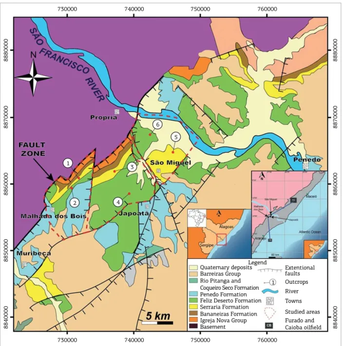
To contemplate this work, three areas were selected in the Sergipe sub-basin, where the widening of BR-101 high-way has provided new outcrops with good lateral extension (Fig.1). he names assigned to these three areas represent the nearest towns: Malhada dos Bois, Japoatã and São Miguel. At the ieldwork, the Serraria and Feliz Deserto formations were mapped allowing the construction of high-resolution stratigraphic logs. As the three studied areas are bordered by faults of uncertain displacement, for each area an individ-ual composed stratigraphic section was elaborated build of the most representative high-resolution sections described at the ieldwork: the Malhada dos Bois compound strati-graphic section is made of the sedimentary logs measured in the points 1 and 2, which were correlated without covered interval, while the Japoatã section is built of the points 3 and 4 with a calculated covered interval of 360 m, and the São Miguel section shows the points 5 and 6 with a calcu-lated covered interval of 400 m. In the Alagoas sub-basin no outcrops suiciently thick to be correlated were found.
he main stratigraphic log is the Outcrop 1 (Fig.1), a135 m thick log along 650 m and the only one in which direct contact between Serraria and Feliz Deserto forma-tions was identiied.
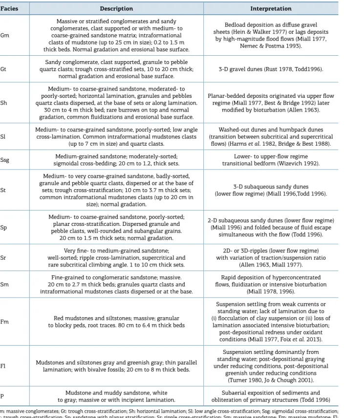
Facies were deined mainly on the basis of grain-size and sedimentary structures, according to the Miall’s (1978) code, adding the letter i at the end when the lamination was incipient or difuse. Gamma Ray logs were run every 50 cm for measured sections and correlated with subsur-face logs. In addition, 24 architectural panels were con-structed from photo-mosaics of sedimentary section no. 1, allowing the determination of the two-dimensional (2D) geometries of the deposits and the bounding surface hier-archy (Miall 1988). Here only the most representative facies associations photo-mosaics are shown. Paleocurrent orien-tations were measured from cross-stratiied beds and were corrected to the horizontal surface based on the S0 depo-sitional surface (Tucker 1996). he subsurface data of this paper are from Caioba Oilield, in the ofshore area of the Sergipe sub-basin, and the Furado Oilield located in the Alagoas onshore area. hese subsurface data were extracted from Borba et al. (2011) and are added to give a regional support to the interpretations.
STRATIGRAPHIC FRAMEWORK
Figure 1. Simpliied geological map of the eastern part of the Sergipe-Alagoas Basin, showing three fault bordered study areas where the six sedimentary logs discussed in this paper are located.
African continents, specially in the opening of the East Brazilian continental margin (Schaller 1969, Assine 2007, Campos Neto et al. 2007). he extension area of this basin comprises part of the states of Sergipe and Alagoas. here are no features dividing the basin in emerged area, as well as deep water, but, as the tectonic style and the stacking pattern in Sergipe state are diferent from Alagoas, two stratigraphic charts were elaborated for the basin (Campos Neto et al. 2007, Schaller 1969). he Mesozoic stratigraphic record of the Sergipe-Alagoas basin relects diferent stages of subsid-ence related to three main phases (Campos Neto et al. 2007):
■ he Pre-Rift phase, characterized by viscoelastic intra-con-tinental lithospheric stretching taking to a regional subsid-ence which extended to most northeastern Brazilian basins.
■ he Rift phase, with accentuated mechanical subsidence, forming graben and/or half-graben systems.
■ he Post-Rift phase, characterized by the predominance of thermal subsidence.
While the Recôncavo-Tucano-Jatobá graben systems represent aulacogen basins, the Sergipe-Alagoas basin has evolved as a passive margin. hus, the stratigraphic record of
730000
1
1 3
6
2
5
4
730000
8840000
8850000
8860000
8870000
8880000
8840000
8850000
8860000
8870000
8880000
740000
740000
750000
750000
760000
760000 Quaternary deposits
Barreiras Group Rio Pitanga and Coqueiro Seco Formation Penedo Formation Feliz Deserto Formation Serraria Formation Bananeiras Formation Igreja Nova Group Basement
Extentional faults Outcrops
River
Towns
Studied areas Furado and
Caioba oilfield
this basin comprises not only the intra-continental pre-rift succession, but the entire record of the rift evolution until those ones related to the passive margin phase.
he basement is composed of Archean to Paleozoic rocks, with diferent compositions being relected in the composi-tion of the sediments illing the basin (Souza-Lima 2006). In the northern part of the state of Alagoas, the basement is composed of granites, gneisses and migmatites, while the southern part of the state and the entire state of Sergipe are composed of folded metasediments with metamorphism ranging green shale facies to amphibolite (Souza-Lima 2006). he basement of the southern part of Sergipe is formed by Archean rocks of the São Francisco Craton and its superimposed Lagarto and Estância sedimentary forma-tions. he Sergipe belt occurs from the Vaza Barris Fault to the north and enters a bit in Alagoas state (Almeida 1977).
Upon the basement, Carboniferous and Permian Igreja Nova Group and later the Perucaba and Coruripe groups were deposited, to which belong respectively to the Serraria and Feliz Deserto formations (Garcia 1991).
he Perucaba group corresponds to the pre-rift sequence and was deposited in intra-continental conditions between Neo-Jurassic and Eo-Cretaceous. During this period, the Sergipe-Alagoas basin represented a segment of the Afro-Brazilian Depression (Ponte & Asmus 1976) that covered the actual Namibia, Brazil and Gabon territories (Kuchle & Scherer 2010). his depression is a wide and shallow basin with small faults, and the deposits are characterized by the great lateral continuity. he Serraria Formation was deposited during the Neocomian and it is described as a succession of medium to coarse sandstones, white, greyish to reddish, poorly to moderately sorted with frequently sub-rounded feldspar and kaolinitic grains and locally conglom-erate (Schaller 1969). hese sediments represent deposits of braided luvial channels systems with aeolian reworking (Campos Neto et al. 2007, Chagas 1996). he subsequent Eo-Cretaceous Coruripe Group, where the Feliz Deserto Formation is inserted, corresponds to the rift sequence and is characterized by mechanical subsidence (Campos Neto et al. 2007). Lithologically, the base of Feliz Deserto Formation is marked by the Caioba Sandstone, ine- to medium-grained tabular luvial deposits up to 10 m thick (Borba et al. 2011), and follows a thick succession of greenish mudstones inter-layered with thin sandstones beds deposited in deltaic-lacus-trine environment (Campos Neto et al. 2007).
LITHOFACIES
Based on the ieldwork observation, the Serraria Formation is composed of quartz sandstones, mudstones and subordinate
conglomerates. Texturally, the sandstones are medium- to very coarse-grained (predominantly medium), moderated- to poorly-sorted and subangular to rounded. Quartz pebbles are common mainly at the base of sets and along stratiica-tions. Mudstones are red, with granular and blocky peds and root traces. he conglomerates have a sandy matrix and are massive or stratiied, with quartz pebbles and intraforma-tional mudstones clasts. Fragments of fossilized tree trunk are common, and bioturbations can occur.
he Feliz Deserto Formation, in turn, is composed of grey to greenish mudstones massive or laminated interlay-ered with ine- to medium-grained quartz sandstones mod-erately- to well-sorted. Based on the sedimentary logs, it was possible to recognize 12 facies (Table 1).
FACIES ASSOCIATION
he Serraria Formation is composed of one facies asso-ciation: braided fluvial channel; and the Feliz Deserto Formation has four facies associations: anastomosed luvial channel, loodplain, prodelta/distal delta front and proxi-mal delta front.
Braided fluvial channel
facies association
Description
Table 1. Summary of lithofacies observed in the Serraria and Feliz Deserto formations.
Gm: massive conglomerates; Gt: trough cross-stratification; Sh: horizontal lamination; Sl: low angle cross-stratification; Ssg: sigmoidal cross-stratification; St: trough cross-stratification; Sp: sandstone with planar stratification; Sr: ripple cross-stratification; Sm: massive sandstone; Fm: massive mudstone; Fl: laminated mudstone; P: paleosol.
Facies Description Interpretation
Gm
Massive or stratified conglomerates and sandy conglomerates, clast supported or with medium- to
coarse-grained sandstone matrix; intraformational clasts of mudstone (up to 25 cm in size); 0.2 to 1.5 m thick beds. Normal gradation and erosional base surface.
Bedload deposition as difuse gravel sheets (Hein & Walker 1977) or lags deposits
by high-magnitude flood flows (Miall 1977, Nemec & Postma 1993).
Gt
Sandy conglomerate, clast supported, granule to pebble quartz clasts; trough cross-stratified sets, 10 to 20 cm thick;
normal gradation and erosional base surface. 3-D gravel dunes (Rust 1978, Todd1996).
Sh
Medium- to coarse-grained sandstone, moderated- to poorly-sorted; horizontal lamination, granules and pebbles quartz clasts dispersed, at the base of sets or along lamination.
30 cm to 4 m thick bed; rare burrows on top and normal gradation, common fluidizations and erosional base surface.
Planar-bedded deposits originated via upper flow regime (Miall 1977, Best & Bridge 1992) later
modified by bioturbation (Allen 1963).
Sl Medium- to coarse-grained sandstone, poorly-sorted; low angle cross-lamination. Common intraformational mudstones clasts (up to 7 cm in size) and quartz clasts.
Washed-out dunes and humbpack dunes (transition between subcritical and supercritical
flows) (Harms et al. 1982, Bridge & Best 1988).
Ssg sigmoidal cross-bedding; 20 cm to 1.2, thick sets.Medium-grained sandstone; moderately-sorted; transitional bedform (Wizevich 1992).Lower- to upper-flow regime
St
Medium- to very coarse-grained sandstone, badly-sorted, granule and pebble quartz clasts, dispersed or at the base of
sets; trough cross-stratification; 10 cm to 3.7 m thick sets; common intraformational mudstones clasts (up to 20 cm in
size); normal gradation.
3-D subaqueous sandy dunes (lower flow regime) (Miall 1996,Todd 1996).
Sp
Medium- to coarse-grained sandstone, poorly-sorted; planar cross-stratification. Dispersed granule and pebble clasts, well-rounded and subangular grains.
20 cm to 1.5 m thick sets; normal gradation.
2-D subaqueous sandy dunes (lower flow regime) (Miall 1996) and folded because of fluid escape
simultaneous with the flow (Todd 1996).
Sr well-sorted; ripple cross-lamination, supercritical and Very fine- to medium-grained sandstone; rare subcritical climbing angle. 1 to 10 cm thick sets.
2D- or 3D-ripples (lower flow regime) with variation of traction/suspension ratio
(Allen 1963, Miall 1977).
Sm 20 cm to 2.7 m thick beds; granules quartz clasts and Fine-grained to conglomeratic sandstone; massive. intraformational mudstones clasts dispersed or at the base.
Rapid deposition of hyperconcentrated flows, fluidization or intensive bioturbation
(Miall 1978, 1996).
Fm to blocky peds, root traces. 80 cm to 6.4 m thick bedsRed mudstones and siltstones; massive; granular
Suspension settling from weak currents or standing water; lack of lamination due to (i) flocculation of clay suspension or (ii) loss of
lamination associated intensive bioturbation; post-depositional redness under oxidant conditions (Miall 1977, Foix et al. 2013).
Fl Mudstones and siltstones gray and greenish gray; thin parallel lamination; with bivalve fossils; 20 cm to 8 m thick beds.
Suspension settling dominantly from standing water; post-depositional graying under reducing conditions, post-depositional
greenish under reducing conditions (Turner 1980, Jo & Chough 2001).
P to gray; massive or with incipient lamination.Mudstone and muddy sandstone, white obliteration of primary structures (Todd 1996)Subaerial exposition of sediments and trough cross-stratiication (Sl/St). Fine-grained sandstones
with ripple cross-stratiication (Sr) are found at the top of some cycles. Fragments of fossilized tree trunks up to 45 cm
Measurements of the cross-strata dip direction display a unimodal pattern with a main vector toward SE.
Sometimes, it is possible to identify compound cross-strata, 1.6 to 4 m thick, which internally displays sets of planar and trough cross-bedding bounded by low angle (<10º) surface with well-developed slipfaces dipping in the same direction of the cross strata. Simple, large-scale planar cross-strata, up to 1.5 m thick are also present (Fig. 2E).
Interpretation
he occurrence of sandstone bodies bounded by erosive surfaces, characterized by medium- to coarse-grained sand-stones, moderately- to poorly-sorted, organized in stacked sets of unidirecionally-oriented, decimeter-scale trough and planar cross-strata forming ining upward cycles, suggests
deposition in luvial channels (Chagas et al. 2007, Miall 1996). he simple, large-scale cross-strata are interpreted as formed by downstream migration of sand bars with well-de-veloped slipfaces, such as transverse bars, alternate bars or tributary mouth bars (Wizevich 1992). Downstream-dipping, inclined compound cross-strata represent the downstream accretion of compound sand bars with superimposed dunes (Fig.3). his element is similar in internal architecture and facies assemblage with mid-channel bars (Wizevich 1992, Miall 1996). he maximum thickness of architectural ele-ments is 4 m and it implies that the maximum bankfull channel depth was 8 m, according the assumption that the architectural element height is at least half the depth of the channel during loods (Bristow 1987). he abun-dance of cross-strata suggests a relatively constant discharge,
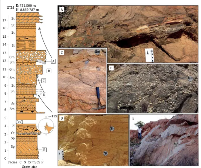
Figure 2. Vertical log of braided luvial channel facies association with paleocurrent direction to SE. (A) Fossilized tree trunk at the base of a cycle; (B) massive conglomerate showing quartz granules and pebbles; (C) massive sandstone with intraformational mudstone clasts; (D) sand bodies with trough cross-stratiication (St) and horizontal lamination (Sh); (E) simple, large-scale planar cross-strata (Sp).
E: 731,066 m N: 8,859,787 m UTM
17
16
15
14
13
12
11
10
9
8
7
6
5
4
3
2
1
0 St
St
Sl
Sl Gm
Gm Sm
Sm
Sm St
Gt St
Sp
Sp
Facies C S fS mS P Grain-size
cS Sh
St
A
C
D
B
E A
B
C
D
Figure 3. Photo-mosaic with (A) interpreted outcrop panel showing cross-strata paleocurrents and bounding surfaces; (B) detailed downstream accretion architectural element interpreted. Note the downstream accretion composed cross-strata and surface dipping toward the same direction that braided luvial cross-strata.
indicating perennial luvial channels (Miall 1996). he fre-quent occurrence of intraformational mudstone clasts indi-cates that rare records of loodplain may have deposited, but they were later eroded by luvial channel avulsions (Kumar et al. 2004). he alternation between horizontal lamination and low angle cross-stratiication (Sh/Sl), as well as between low angle cross-stratiication and trough cross-stratiication (Sl/St), suggests variation of discharge energy. he abun-dance of fossilized tree trunk founded suggests a relatively humid climate. he multistory stratiied sand bodies with thick macroforms, low dispersion of paleocurrents, lack of well-deined ining-upward cycles and the high occurrence of simple to compound downstream accretion architectural element collectively suggest a low-sinuosity, deep perennial braided river.
Anastomosed fluvial
channel facies association
Description
his facies association extends over more than 50 m in outcrop and consists of sandstone bodies up to 4 m thick, composed of medium-grained white to gray sandstones, well-sorted with tabular geometry. hese sandstone bodies are isolated from each other and separated by an extensive succession of red mudstones (Fig.4 and Fig.5), internally exhibit weakly developed ining-upward pattern with a pre-dominant aggradational trend and are bounded at the base by erosive or difuse surface. hese bodies are formed by 20 to 30 cm thick sets of trough cross-stratiication (St) (Fig. 4C), planar cross-stratiication (Sp) low angle cross-stratiication
Legend 56º 160º Paleocurrent
migration direction Fossil trunk 1st-order bounding surface 2nd-order bounding surface 3rd-order bounding surface 4th-order bounding surface 5th-order bounding surface Downcurrent-accretion cross strata Low-angle cross-bedded sandstone Trough cross-bedded sandstone Incipient low angle cross-bedded
(dip dip direction) 45º/140º
A
Figure 4. Vertical log of anastomosed luvial channel facies association showing: (A) sandstone with bioturbation on top; (B) intense luidization on sandstone obstructing structure identiication; (C) ine-grained moderately-sorted sandstone with trough cross-stratiication; (D) lame structure; (E) low-angle cross-stratiication on well-sorted ine-grained sandstone; (F) muddy sandstone with incipient lamination; (G) general view of sandstone bodies laterally interlayed with mudstones.
Figure 5. Photo-mosaic of anastomosed luvial channel. Note the association with ine sediments and (A) interpreted outcrop panel showing facies, cross-strata paleocurrents and bounding surfaces.
1st-order bounding surface 2nd-order bounding surface
Low-angle cross-bedded sandstone Trough cross-bedded sandstone
Incipient trough cross-bedded sandstone Massive sandstone
Massive mudstone Paleosol Legend
1 2
1
2 2 2
2 2 2
Sl
Sl
Sl
St
St
Sti
Sti Sti
Sm
Sm
Fm Fm
P
0 1m
A
P
E: 731,008 m N: 8,859,694 m UTM
111 Sh
Sl
Sl
Sl
St Sp St Sm
Sm Sti Sm St Sl Sm Sl/St
P Sm Gm
Gm 110
109
108
97
96
95
94
93
91
90
89
88 101
100
n=8
Facies C S tS mS cS P A
C
E
F
B
D
G A
B
C
F D
G E
sandstones (Sl) (Fig. 4E), massive sandstone (Sm) with dis-persed granule and intraformational mudstone clasts and rare beds of white, massive, very-ine sandstones to silt-stone or with incipient lamination (P)(Fig. 4F and G). Sometimes bioturbation on top of beds (Fig. 4A) occurs, and the sand bodies can be intensely luidized, displaying lame structures (Fig. 4B and D). Due to the low quality of preservation of these sandstone and intense luidization, only eight measures of paleocurrent were collected.
Interpretation
he occurrence of sandstone bodies bounded by erosive surfaces, characterized by sandstones with decimeter-scale unidirecionally-oriented sets of trough and planar cross-strata forming ining upward pattern, suggests deposition in luvial channels (Chagas et al. 2007, Miall 1996).he lack of macro-forms indicates that the channel illing occurs by migration and climbing of subaqueous dunes (SB element of Miall 1985). he predominant aggradational stacking trend of channels
and low amount of mudstones clasts indicate channel stability and rare lateral migrations, suggesting the presence of cohe-sive banks rarely eroded. Aggradational channel sandstone bodies, rare lateral migrations, stable banks and intercalation with ine deposits indicate a network of interconnected luvial channels separated by constantly looded parts and suggest anastomosed luvial channel deposits (Smith &Smith 1980).
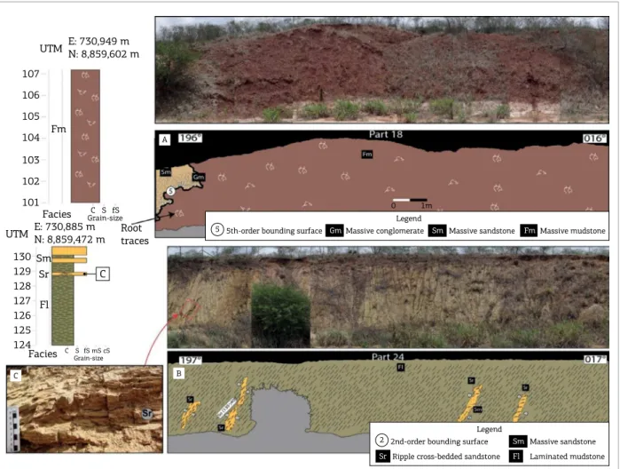
Floodplain facies association
Description
his facies association has a variable thickness, from 0.8 to 6.4 m, and laterally extensive for up to 15 m. hese depos-its are composed of red to gray massive mudstones and silt-stones (Fm) (Fig. 6A). he reddish mudsilt-stones display gray slickensides along fracture planes, root traces and granular and blocky peds. his facies association occurs interlayered with anastomosed luvial channel facies association sand-stone bodies.
Figure 6. Schematic loodplain and prodelta/distal delta front log with related photomosaic. (A) Interpreted outcrop panel of prodelta; (B) prodelta/distal front. Note the reddish tone of loodplain ine sediments diferent from the greenish tone of prodelta/distal delta front where ine sediments are interlayered with progressively thicker sandstone beds. (C) Detail picture of ripples cross-lamination within distal delta front sandstones.
E: 730,949 m N: 8,859,602 m UTM
E: 730,885 m N: 8,859,472 m UTM
107
106
105
104
103
102 Fm
Sm Sr
Fl 101
130 129 128 127 126 125 124
Facies
Facies
C S fS
C S fS Grain-size
mS cS Grain-size
Root traces
5th-order bounding surface
5 GmMassive conglomerate Sm Massive sandstone FmMassive mudstone Legend
2nd-order bounding surface 2
Ripple cross-bedded sandstone
Sr
Massive sandstone
Sm
Laminated mudstone
Fl
Legend A
B C
0 1m
Interpretation
Fine sediments settle by decantation in low energy environments. he occurrence of red mudstones associ-ated with root traces, slickensides, granular and blocky peds indicates well-drained vegetated loodplains that were subjected to periods of non-deposition and subsequent oxidation and development of paleosol (Bown & Krause 1987, Kraus 1999, herrien 2006, Cleveland et al. 2007, Retallack 2008). Surfaces with slickensides are interpreted as being formed by shrinking and swelling of clays, asso-ciated with episodic water iniltration and evaporation (Retallack 1994). he granular and blocky peds are inter-preted as types of argilans formed in clay-rich paleosols (Sigleo and Reinhardt 1988).
Prodelta/distal delta
front facies association
Description
his facies association is characterized by up to 8 m thick deposits and internally form cycles with coarsen-ing-upward pattern. hese cycles are composed, at the base, by 1 to 7 m thick beds of gray to greenish parallel laminated (Fl) and massive mudstone (Fm). Sometimes these mudstone interlayers with thin beds of very ine- to ine-grained sandstone forming laser, wavy and linsen heterolitic bedding. Towards the top the mudstones inter-layer with progressively thicker sandstone beds (10 cm to 1 m thick), ine- to medium-grained, moderated-sorted, gray to yellow, massive (Sm), with ripple cross-lamina-tion (Sr) (Fig. 6C) or trough cross-stratiicacross-lamina-tion (St). Bivalve fossils can be found. his facies association has an abrupt basal contact with anastomosed luvial chan-nel sandstone bodies.
Interpretation
he abundance of mudstones interlayered with thin sandstones is indicative of deposition in a quiet-water environment with periodic input of sand. he laminated mudstones at the base of cycles are generated by gravita-tional settling of suspended particles below the level of wave performance, being interpreted as prodelta depos-its. Massive and unidirectionally-oriented sandstone intercalated with mudstones suggests that these sediment beds represent respectively hyperconcentrated lows in which the current density is higher than that one of the receiving body-water and low density turbidity currents, caused by periodic increases in the discharge of the river (Bhattacharya 2006). hese progressively thicker sand-stones beds represent progradation of delta front facies association upon prodelta.
Proximal delta front facies association
Description
his facies association is characterized by intensely luid-ized sandstone beds up to 10 m thick, composed by mod-erated- to well-sorted ine- and medium-grained sandstones with sigmoidal cross-stratiication (Ssg), trough cross-strati-ication (St), ripple cross-straticross-strati-ication (Sr) and massive sand-stone (Sm). he sandsand-stone beds become progressively thicker and more frequent characterizing coarsening-upward cycles. his facies association shows a gradual transition with prodelta/ delta front deposits below. he paleocurrent measurement dis-plays a wide spreading. his facies association was found at the point 2 (), which stratigraphic position is above point 1. he limited extension of the outcrop and abundant vegetation limit the construction of photo-mosaic and good photography.
Interpretation
he facies succession characterized by sandstone beds with intense luidization, coarsening-upward cycles and asso-ciated with prodelta deposits suggests delta front deposits (Bhattacharya 2006). he abundance of unidirecionally-ori-ented cross-stratiication sets indicates a constant discharge current and suggests a river dominated delta front facies association. According to Bhattacharya (2006), intense lu-idization is common in river dominated deltas and indicates a high sedimentation rate over water-saturated sediments resulting in luid expulsion and causing bed deformations in the overlapping sandstones. A predominantly sandy delta front facies association indicates rapid deceleration of unidi-rectional low (Bhattacharya 2006). Sigmoidal cross-strati-ications are generated by a transitional bed forms between dunes and lat beds strata (Wizevich 1992). he sigmoidal shape of this structure is a result of the relation between traction and particle settling.
STRATIGRAPHIC CONTEXT
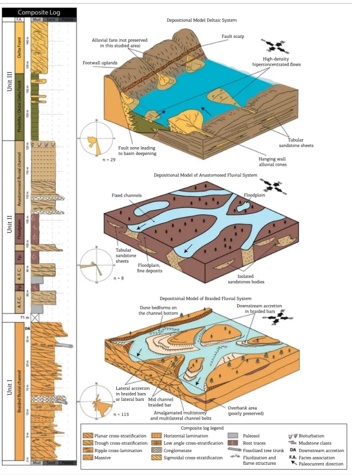
Figure 7. Composite log of the sedimentary succession showing depositional model of each unit (modiied from Scherer et al. 2014). Unit I represents braided luvial channels with downstream accretion bars. Unit II shows
anastomosed luvial channels separated by loodplain deposits. Unit III represents a half-graben geometry with delta systems on the lexural margin and some hyperconcentrated sediments.
Unit I
Unit II
Unit III
Alluvial fans (not preserved in this studied area)
Footwall uplands
Fault scarp
High-density hiperconcentrated flows
Fault zone leading to basin deepening n = 29
Tabular sandstone sheets
Tabular sandstone sheets
Hanging wall alluvial cones Depositional Model Deltaic System
Depositional Model of Anastomosed Fluvial System
Depositional Model of Braided Fluvial System Floodplain Fixed channels
Floodplain, fine deposits
Isolated sandstones bodies n = 8
n = 115
Dune bedforms on the channel bottom
Downstream accretion in braided bars
Lateral accretion in braided bars
or lateral bars Mid channel braided bar
Amalgamated multistorey and multilateral channel belts
Overbank area (poorly preserved)
Composite log legend Planar cross-stratification
Trough cross-stratification Ripple cross-lamination Massive
Horizontal lamination Low angle cross-stratification Conglomerate
Sigmoidal cross-stratification
Paleosol Root traces Fossilized tree trunk Fluidization and flame structures
Figure 8. Correlation section along Sergipe-Alagoas Basin. Each compound stratigraphic section shows the sedimentary logs as described during ieldwork and the calculated covered interval. Note the similarity between gamma ray of sedimentary logs and subsurface data that allowed correlation: low and uniform values in unit I, then high values, indicating loodplain deposits, and a small interval of regular and low values, which suggests Caioba anastomosed luvial sandstones (unit II) and on the top several cycles of progressive reducing of gamma values, suggesting progradations stacking pattern typical of Feliz Deserto.
SW Caioba Oilfield Malhada dos Bois Japoatã São Miguel Furado Oilfield NE
5,7 km 10,5 km
Correlation section Legend
Localization map Progradation cycles
Delta
Braided Fluvial Channel
Anastomosed Fluvial Channel Fault Covered
Caioba Field
Furado Field Main citiesSedimentary logs Sergipe-Alagoas BasinBasement Correlation section established in humid climatic conditions during the initial
moments of rifting and with similar deposits preserved in all territories that belonged to this depression.
The unit II, which corresponds to the base of Feliz Deserto Formation, is characterized by a network of anas-tomosed luvial channels separated by vegetated loodplains. he change of luvial system from braided to anastomosed between these two units relects an increase in the rate of accommodation allowing preservation of mudstone beds progressively thicker and the aggradation of luvial chan-nel sandstone bodies known as Caioba Sandstone some-times exposed to sub-aerial conditions. he low number of paleocurrent measures does not allow further interpre-tations, but units I and II have the same detrital composi-tion suggesting that the source area is probably the same.
he unit III corresponds litho-stratigraphically to the Feliz Deserto Formation and is characterized by coarsening- and thickening- upward cycles, composed by prodelta/distal delta front facies association at the base and progressively evolving to proximal delta front facies association indicating prograda-tional deltaic lobes (Fig. 7 and ). he paleocurrent direction displays a high dispersion (8 measures toward W, 11 toward
SW and S and 3 toward E and SE), suggesting that sedimen-tation occurred in restricted basins with sedimentary inlux from several lanks. he contact between units II and III is marked by prodelta mudstone superimposed on anastomo-sed luvial channel sandstones and indicates a rapid lood-ing. he change on paleocurrent direction added to the rapid looding suggests that the basin underwent a signiicant rear-rangement associated with tectonic movements. he change of depositional system conirms the restructuring of the basin and suggests that the increasing rate of accommodation cre-ation already observed in unit II becomes more intense.
TECTONIC-STRATIGRAPHIC
EVOLUTION
available in previous studies suggest that these units were deposited in a large sedimentary basin related to the ini-tial stage of Neocomian rifting (Campos Neto et al. 2007, Kuchle et al. 2011). he Serraria Formation was deposited in the north lank of this large and shallow basin whose depocenter was located at the SE of Sergipe-Alagoas Basin (Kuchle et al. 2011).This accumulation phase has been called Rift Initiation Tectonic System Tract by Kuchle and Scherer (2010), instead of the term Pre-Rift attributed by Campos Neto et al. (2007), that is restricted to rocks that are completely unrelated to the rifting process, consisting of sedimentary basement upon which taphrogenic processes will act (Prosser 1993, Bosence 1998, Scherer et al .2014). he unit I has sedimentological-stratigraphical charac-teristics and paleocurrent patterns suggesting that the Rift Initiation Tectonic System Tract is characterized by incipient extensional stress generating a wide synclinal depression, asso-ciated to the low rate, continuous and uniformly distributed tectonic activity (Morley 2002, Kinabo et al. 2007, Kuchle et al. 2011). he predominance of multi-storey amalgam-ated sandstone bodies without deposits from outside channel along this unit indicates low accommodation creation rate and is related to a uniform A/S ratio with positive- close to 0 values (Martinsen et al. 1999, Scherer et al.2014).
he unit II represents a transition interval between the rift initiation and the individualization of half-grabens. Amalgamated sandstone bodies are replaced by isolated sandstone bodies allowing preservation of loodplain ine deposits. he character aggradational of luvial channel sand-stones and the substantial thickness of mudsand-stones indicate a progressive increase of the accommodation creation rate and A/S ratio less than 1 (Martinsen et al. 1999, Scherer et al. 2014). his unit still belongs to the Rift Initiation Tectonic System Tract suggesting the shallow character of the basin, interpreted from the oxidation of mudstones, but the increase of A/S ratio indicates that the tectonic activity becomes more and more intense, however without individ-ualization of half-grabens.
he unit III is characterized by a thick deltaic succes-sion indicative of a deeper basin and high A/S ratio above 1 (Martinsen et al. 1999, Scherer et al. 2014). Besides, the scat-tering in paleocurrent direction and the fact that mudstones of unit III are superimposed on luvial channel sandstones of unit II are consistent with the fragmentation of the wide basin in several smaller and deeper basin: the half-grabens (Prosser 1993, Bosence 1998, Gawthorpe & Leeder 2000). According to Prosser (1993) the sedimentary inlux of half-gra-ben occurs from diferent regions, resulting in a high dis-persion of the paleocurrent. herefore, unit III can be con-sidered as deposited during the Half Graben Development Tectonic System Tract (Kuchle & Scherer 2010).
he prodelta mudstone superposed abruptly over anas-tomosed luvial channel sandstone bodies characterizes a looding surface between units II and III. In this way, the succession studied evidence that the passage between rift initiation and half-graben development is extremely rapid and marked by a radical change both in depositional sys-tems and geometric characteristics of the basin.
he abrupt nature of this contact can be consistently demonstrated with subsurface data. he unit I is identiied in gamma ray logs by a thick interval of low and uniform values indicating sandstone bodies. he unit II is marked by the irst high value of gamma ray after unit I and it is characterized by an intercalation of high values, indicating loodplain deposits, and a small interval of regular and low values, which suggests Caioba anastomosed luvial sandstones. he Half Graben Development Surface (Kuchle & Scherer 2010) was observed in each subsurface log and is marked by a sharp increase in gamma ray values subsequent to unit II, suggesting a fast looding of the lacustrine deltaic depo-sitional system. Above this surface there are several cycles of progressive reducing of gamma values, suggesting sandstone bodies on top of mudstone deposits and characterizing progra-dations stacking pattern typical of Feliz Deserto Formation. As suggested by Kuchle and Scherer (2010), the rift basin’s analysis should be done individually for each half-gra-ben as these may be in diferent evolutionary stages due to the extensional behavior that varies in time and along the basin. So, considering that the Half-Graben Development Tectonic System Tract is not a synchronic event along the basin, the correlation made in Fig. 8 does not relate events that occurred at the same time, but simply use the Half-Graben Development Surface to diferentiate the stages.
CONCLUSIONS
It was possible to individualize three depositional units in the Neo-Jurrasic and Neocomian succession of Sergipe-Alagoas Basin: unit I, which corresponds to the base of Serraria Formation, is characterized by multi-storey and multi-lateral, amalgamated sandstone bodies of braided luvial channel sys-tem; unit II, equivalent to the base of Feliz Deserto Formation, is composed of anastomosed luvial channel sandstones inter-layered with loodplain mudstone deposits; Unit III, that cor-responds to the major part of Feliz Deserto Formation and is composed of prodelta and delta front deposits.
of delta depositional systems bordering the lacustrine bod-ies. While the paleocurrent direction of unit I is unimodal, toward SE, where was located the depocenter, the paleocur-rent direction of unit III has a high dispersion and suggests that an important restructuration and fragmentation of the basin in several half-grabens occurred, each one with its own depocenter and sedimentary inlux from diferent regions.
Based on the results of this work, it is possible to under-stand the stratigraphic evolution of the initial stages of
rifting. Corroborating the proposals of Morley (2002) and Kuchle and Scherer (2010), we conclude that the irst stage of rifting (units I and II) is characterized by a wide basin, unlike the models of Prosser (1993), Bosence (1998) and Gawthorpe and Leeder (2000), who suggest the presence of restricted or isolated basins already in the irst instants of the rift. his wide basin has a low A/S ratio. he establish-ment of half-graben occurs at the second stage (unit III), due to increase of tectonic activity and increase of A/S ratio.
Allen J.R.L. 1963. The classiication of cross-stratiied units.With
notes on their origin. Sedimentology, 2(2):93-114.
Almeida F.F.M. 1977. O Cráton do São Francisco. Revista Brasileira
de Geociências, 7(4): 349-364.
Assine M.L. 2007. Bacia do Araripe. Boletim de Geociências,
15(2):371-389.
Bhattacharya J.P. 2006. Deltas. In: Posamentier H.W. & Walker R.G.
(eds.) Facies Models Revisited. Society of Economic Paleontologists and
Mineralogists. Special Publication 84, Oklahoma, USA, Tulsa, p. 237-292. Best J. & Bridge J.1992. The morphology and dynamics of low amplitude bedwaves upon stage plane beds and the preservation of
planar laminae. Sedimentology, 39(5):737-752.
Borba C., Paim P.S.G, Garcia A.J.V. 2011. Estratigraia dos depósitos iniciais do rite no Campo de Furado, região de São Miguel dos Campos,
Bacia de Sergipe-Alagoas. Revista Brasileira de Geociências, 41(1):18-36.
Bosence D.W.J. 1998. Stratigraphic and sedimentological models of rit basins. In: Purser B.H., Bosence D.W.J. (eds.) Sedimentation and Tectonics
of Rit Basins: Red Sea – Gulf of Aden. London, Chapman & Hall, p. 9-25. Bown T.M. & Krause M.J. 1987. Integration of channel and loodplain suites,developmental sequence and lateral relations of alluvial
palaeosols. Journal of Sedimentary Petrology, 57(4):587-601. Bridge J.S. & Best J.L. 1988. Flow, sediment transport and bed form dynamics over the transition from dunes to upper-stage plane beds:
Implications for the formation of planar laminae. Sedimentology,
35(5):753-763.
Bristow C.S. 1987. Brahmaputra river: channel migration and
deposition. In: Ethridge F.G., Flores R.M., Harvey M.D. (eds.) Recent
Developments in Fluvial Sedimentology. Society of Economic
Paleontologists and Mineralogists, Special Publication 39, Oklahoma,
USA, Tulsa, p. 63-74.
Campos Neto O.P.A.,Souza Lima W.,Cruz F.E.G.2007. Bacia de
Sergipe-Alagoas. Boletim de Geociências, 15:405-415.
Chagas L.S.1996. Tectono-sedimentação das bacias do tipo rite:
aplicação na porção emersa da Bacia de Sergipe-Alagoas. MS Dissertation, Instituto de Geociências, Universidade Federal do Rio
Grande do Sul, Porto Alegre, 322p.
Chagas D.B., Assine M.L., Freitas F.I. 2007. Facies Sedimentares e ambientes deposicionais da Formação Barbalha no Vale do Cariri,
Bacia do Araripe, Nordeste do Brasil. Geociências, 26(4):313-322.
Cleveland D., Atchley S., Nordt L. 2007. Continental sequence stratigraphy of the Upper Triassic (Norian–Rhaetian) Chinle strata, Northern New Mexico, U.S.A.: Allocyclic and autocyclic origins
of paleosol-bearing alluvial successions. Journal of Sedimentary
Research, 77:909-924.
REFERENCES
Foix N., Paredes J.M., Giacosa R.E. 2013. Fluvial architecture variations linked to changes in accommodation space: Río Chico Formation (Late Paleocene), Golfo San Jorge basin, Argentina.
Sedimentary Geology, 294:342-355.
Garcia A.J.V. 1991. Estratigraia, sedimentação e diagênese dos
arenitos da Formação Serraria, Cretáceo Inferior da Bacia de Sergipe-Alagoas, Nordeste do Brasil. PhD Thesis, Instituto de Geociências,
Universidade Federal do Rio Grande do Sul, 305p.
Gawthorpe R.L. &LeederM. R. 2000. Tectono-sedimentary evolution
of active extensional basins. Basin Research, 12(3-4):195-218.
Harms J.C., Southard J.B., Spearing D.R., Walker R.G. 1982. Structures
and sequences in Clastic Rocks. SEPM Short Course9, 161p.
Hein F.J. & Walker R.G. 1977. Bar evolution and development of stratiication in thegravelly, braided, Kicking Horse River, British
Columbia. Canadian Journal ofEarth Science, 14(4):562-570.
Jo H.R. & Chough S.K. 2001. Architectural analysis of luvial sequences in the northwestern part of Kyongsang Basin (Early
Cretaceous), SE Korea. Sedimentary Geology, 144(3-4):307-334.
Kinabo B.D., Atekwana E.A., Hogan J.P., Modisi M.P., Wheaton D.D., Kampunzu A.B. 2007. Early structural development of the Okavango rit
zone, NW Botswana. Journal of African Earth Sciences, 48(2-3):125-136.
Kraus M.J. 1999. Paleosols in clastic sedimentary rocks: Their
geologic applications. Earth-Science Reviews, 47(1-2):41-70. Kuchle J. & Scherer C.M.S. 2010. Sismoestratigraia de bacias rite:
técnicas, métodos e sua aplicação na Bacia do Recôncavo. Boletim de
Geociências da Petrobras, 18(2):33-60.
Kuchle J., Scherer C.M.S.,Born C.C., Alvarenga R.S., Adegas F. 2011. A contribution to regional stratigraphic correlations of the Afro-Brazilian – The Dom João Stage (Brotas Group and equivalent units – Late Jurrassic) in Northeastern Brazilian sedimentary basins.
Journal of South American Earth Sciences, 31(4):358-371.
Kumar R., Sangode S.J., Ghosh S.K. 2004. A multistorey sandstone complex in the Himalayan Foreland Basin, NW Himalaya. India.
Journal ofAsian Earth Sciences, 23(3):407-426.
Martinsen O.J., Ryseth A., Helland-Hansen W., Flesche H., Torkildsen G., Idil S. 1999. Stratigraphic base level and luvial architecture: Ericson Sandstone (Campanian), Rock Springs Uplit, SW Wyoming,
USA. Sedimentology, 46(2):235-263.
Miall A.D. 1977. A review of the braided-river depositional
environment. Earth-Science Reviews, 13(1):1-62.
Miall A.D. 1978. Lithofacies types and vertical proile models in braided rivers deposits: a summary. In: Miall A.D. (ed.). Fluvial
Sedimentology,Canadian Society of Petrology and Geology, Memoir,
Miall A.D. 1985. Architectural-elements analysis: Anew method of
facies analysis applied to luvial deposits. Earth-Science Reviews,
22(4):261-308.
Miall A.D. 1996. The Geology of Fluvial Deposits: Sedimentary Facies, Basin
Analysis and Petroleum Geology. New York, Springer-Verlag, 582 p. Miall A.D. (ed.) 1988. Facies Architecture in clastic sedimentary
basins. In: Kleinspehn K.L.& Paola C. (eds.)New perspectives in basin
analysis, 1, Berlin: Springer-Verlag, p. 67-81.
Morley C.K. 2002. Evolution of large normal faults: Evidence from
seismic relection data. The American Association of Petroleum
Geologists Bulletin, 86(6):961-978.
Nemec W. & Postma G. 1993. Quaternary alluvial fans in southwestern
Crete: Sedimentation processes and geomorphic evolution. In: Marzo
M.& Puigdefrabegas C. (eds.) Alluvial Sedimentation, International
Association of Sedimentologists, Special Publication, 17, Oxford, Blackwell Scientiic Publications, p. 235-276.
Ponte F.C., Asmus H.E. 1976. The Brazilian margin basins – current
state of knowledge. Anais da Academia Brasileira de Ciências,
48:215-240.
Prosser S. 1993. Rit-related linked depositional systems and
their seismic expression. In:Williams G.D.&Dobb A. (eds.)Tectonics
and Seismic Sequence Stratigraphy. Geological Society, Special
Publication, 71, London,p. 35-66.
Retallack G.J. 1994. The environmental factor approach to the interpretation of paleosols, factors in soil formation-a itieth
anniversary perspective. In: Luxmoore R.J. (ed.) Factors of Soil
Formation: Soil Science. Science Society of America,Special
Publication, 33, Madison, p. 31-64.
Retallack G.J. (ed.). 2008. Soils of the Past; an Introduction to
Paleopedology.Oxford, Blackwell Science,404 p.
Rust B.R. 1978. A classiication of alluvial channel systems. In:
Miall A.D. (ed.)Fluvial Sedimentology. Canadian Society Petroleum
Geologists Memoir, 5, Calgary, p. 187-198.
Scherer C.M.S., Jardim de Sá E.F., Córdoba V.C., Sousa D.C., Aquino M.M., Cardoso F.M.C. 2014. Tectono-stratigraphic evolution of the Upper Jurassic-Neocomian rit succession, Araripe Basin, Northeast
Brazil. Journal of South American Earth Sciences, 49:106-122. Sigleo W. & Reinhardt J. 1988. Paleosols from some Cretaceous
environments in the southeastern United States. In: Reinhardt J. &
Sigleo W. (eds.) Paleosols and Weathering Through Geologic Time:
Principles and Applications. Geological Society of America, Special
Paper, 216, Colorado, p. 123-142.
Smith D.G.& Smith N.D. 1980. Sedimentation in anastomosed river
systems;examples from alluvial valleys near Banf, Alberta. Jornal of
Sedimentary Petrology, 50:157-164.
Souza-Lima W.2006. Litoestratigraia e evolução tectono-sedimentar
da bacia de Sergipe-Alagoas (introdução). Fundação Paleontológica
Phoenix, 89:1-10.
Schaller H. 1969. Revisão estratigráica da Bacia de Sergipe/Alagoas.
Boletim Técnico da Petrobras, 12(1):21-86.
Therrien F. 2006. Depositional environments and luvial system changes in thedinosaur-bearing Sânpetru Formation (Late Cretaceous, Romania): Post-orogenic sedimentation in an active
extensional basin. Sedimentary Geology, 192(3-4):183-205.
Todd S.P. (1996). Process deduction from luvial sedimentary
structures. In: Carling P.A.&Dawson M.R. (eds.)Advances in Fluvial
Dynamics and Stratigraphy. John Wiley, Chichester, p.299-350.
Turner P. 1980. Continental Red Beds. Developments in Sedimentology.
Amsterdam, Elsevier, 562p.
Tucker G.E. 1996. Sedimentary rocks in the ield. John Wiley and
Sons, Chinchester, England.
Wizevich M.C. 1992. Sedimentology of Pennsylvanian quartzose sandstones of the Lee Formation, central Appalachian Basin: Fluvial
interpretation based on lateral proile analysis. Sedimentary Geology,
78(1-2):1-47.