DOI: 10.7213/urbe.7398
"
ISSN 2175-3369
Licenciado sob uma Licença Creative Commons
Polise Moreira De Marchi
Telefones celulares: uma cartografi a digital de São Paulo
Architect, PhD in Architecture and Urbanism University of São Paulo , professor, researcher and executive coordinator of )novaCidades at Senac University Center, São Paulo, SP- Brazil, e-mail: [email protected]
Abstract
The fundamental function of maps has always been to understand, interpret, and represent the world. Therefore, maps have a communication role, as a language. As communication tool, maps spatialize the interaction of social, economic and cultural urban realities in a graphic expression that provides the very meaning of urban systems. The aim of this paper is to report an academic study involving digital interface design graduate students. They investigated the role of locative media as potential instruments for registering and mapping experiences, obser-vations and perceptions of urban life. This study considers that students can stimulate interactions across the city, whether, directly, in its physical space or, indirectly, through interfaces such as cell phone applications. The project also sought to discuss the cell phone as a producer of new languages, since instead of being merely a tele-phone it combines the functions of different media and can produce images, videos, sounds etc.
Keywords: Mobile phones. Locative media. Urban cartography. Urban interface. Semiotics.
Resumo
Desde as suas origens, os mapas foram feitos para definir um modo de compreensão, interpretação e representação
do mundo, e deste modo, eles exercido continuamente o papel de atuar como linguagem e elemento de comunicação. Como ferramenta de comunicação, os mapas são capazes de espacializar a interação entre a realidade urbana
so-cial, econômica e cultural em uma expressão gráfica que fornece o significado do próprio sistema urbano. O objetivo
deste trabalho é apresentar um projeto desenvolvido para o curso de graduação em design de interface digital que consistiu em reconhecer as mídias locativas como potencial instrumento para registro de experiências, observações e percepções da vida urbana, e do mapeamento destes registros, capazes de estimular o projeto na cidade, seja
diretamente em seu espaço físico ou por meio de interfaces, como os próprios aplicativos para celulares. Além disto, objetivou-se também discutir o aparelho celular como produtor de novas linguagens, uma vez que mais que um telefone, o aparelho se tornou um agregado de mídias capazes de gera imagens, vídeos, sons etc
Palavras-chave : Telefones celulares, mídia locativa, cartografia urbana, interface urbana, semiótica.
Introduction
The city concentrates all the metaphors of the digital age: network, interface, interaction, territo-ry, representation and connection. Between city and experience, the technological interface represents an opportunity for learning about and producing real or potential spatial relations.
The city is porous, and concrete physical situations and digital networks penetrate each other, increas-ingly constituting manifestations of an extended real-ity, a hybrid environment where virtual and physical
objects mix M)TC(ELL, . As Melvin Webber and
the Archigram group have argued in the late s, it
is not possible to consider technology as a mere in-strument or system dissociated from the context of contemporary cities.
The urban world has been increasingly illed in with data and information. The need for understand-ing where we are and how we displace to/from some-where has been daily incorporated by mobile devices, as they become increasingly extensions of ourselves, of our cognitive ability to understand the world and to enable its mapping. At the same time, mobile devices as locative media play a fundamental role by poten-tializing the generation and dissemination of informa-tion in city spaces and, consequently, the producinforma-tion of new cartographies as the user becomes a potential builder of urban geo localized databases.
According to (enri Lefebvre , technology
has de ined and delimited the various stages of the city in its history, in terms of the physical dynamics of space, as well as in relation to its representation. Recently it has been even more intensi ied, once technology is able to act as mediation between citi-zens and the urban space.
All these statements are particularly relevant to the academic environment of design disciplines,
especially those dealing with urban interfaces and interaction design. The act of designing is materi-alized from reading and understanding the world through an attentive eye, motivated by a curious mind that is able to infer problems that re lect the dissatisfaction of designers regarding the incom-pleteness of the world around them. Thus, the idea of taking into account a more critical approach of these re lections is justi ied, once design aims to put forward new ways of improving the environment around us as a continuum process of its develop-ment. For this reason, it is necessary to discuss and to experience how to deal with these technologies that provide us new ways of exploring, observing and describing the urban environment around us and, at the same time, to understand how informa-tion and communicainforma-tion technologies and mobile devices can help us reorganize it.
This article is about the experimental project Mobile Digital Cartographies . )t was developed
between and as part of the digital
inter-face design course at Senac University Center in São Paulo. The main question addressed by the proj-ect was how to provide new ways of understand-ing the urban environment in São Paulo by means of experiencing and registering its urban daily life through mobile phones, considered as locative mul-timedia tools, and transforming the collected data into different cartographies of the city , specially for those who will work as designers in this urban con-text. This question was formulated following what
was pointed out by Emerson , p. : We
organize information on maps in order to see our knowledge in a new way. As a result, maps suggest explanations; and while explanations reassure us, they also inspire us to ask more questions, consider
other possibilities. To ask for a map is to say Tell me
a story.
at that point. The initial hypothesis was that the knowledge about the city was contaminated by mass media content and language, which overlapped the concrete experience.
After that, they were invited to observe and reg-ister, with their mobile phones, their everyday life experience in São Paulo. All captured material had to be organized into iles classi ied and spatialized on Google Maps website by date, place and concept. Then, the third stage consisted in organizing, select-ing and processselect-ing their multimedia results into cartographies of São Paulo. The last stage was to confront the different maps, combining them into a panoramic view of different representations of the city using mobile and locative technologies.
Mobile digital cartographies
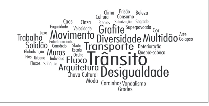
)nitially, a discussion was held with those who took part in the Mobile Digital Cartographies proj-ect about what readings and perceptions they had of the city as well as what information they had about it. Based on collective discussions, a semantic map Figure of the city was created, in which a priori concepts and meanings were organized hi-erarchically according to how frequently and with what intensity they were mentioned by students.
Although to a large extent this semantic map-ping re lected the common collective media imagi-nary about the city, it was essential as a point of ref-erence in the deconstruction of the semantic model that had prevailed prior to the project and was sub-sequently reaf irmed when the participants created graphical metaphors using postcards that sought in some way to represent the city.
The aim of the second exercise was to create visual cards in an attempt, through pictorial ab-straction, to establish an iconic dialog between the individual imaginary and the representation of the city. While in the first exercise the meaning attributed to words predominated, in the second the focus was on the iconic aspect of translating the city. The meaning was determined by the im-age. As a result, the conventions attributed to the city through words at times did not have a cor-responding image and at other times had their meaning expanded or changed by the images at-tributed to them.
The idea of maps as story-telling artifacts al-lowed us to systemize the results of the proposed urban experience, which was based on a phenome-nological approach to the city. This idea consists in seeing the urban life as a phenomenon. Following
the ideas of Charles Sanders Peirce , the
phenomenological approach was conceived by three stages of faculty. The irst faculty is that of seeing/observing. The second faculty is having the capacity of discriminating what is observed. The third faculty is the ability of generalizing the whole experience.
Thus, the project was supposed to achieve the following goals:
- to motivate observation, perception and cre-ation of mappings urban experience by means of mobile and location-based technologies; - to discover the city using reports based on
per-sonal experience as it is lived and perceived in daily life and to provide a counterpoint to and additional layer over other mass-media con-structions that acting unveiling urban events in different situations. From the everyday life to the collective social movements;
- to understand mobile and locative technolo-gies as an extension of the body and mind in daily activities, in view of its increasing and ever more effective role as mediator between information and action in urban space; - to investigate the role of locative media as
po-tential instruments for making records of ur-ban life and mapping these records, which can stimulate projects in the city, whether directly in its physical space or indirectly through inter-faces such as cell phone applications;
- to discuss the cell phone as a producer of new languages, since instead of being merely a telephone it combines the functions of dif-ferent media and can produce images, videos, sounds etc.
As a methodological strategy, the project was divid-ed in four stages basdivid-ed on regarding the city through a phenomenological approach: deconstructing, observ-ing/perceiving, constructing and combining.
using cell phones by mapping the real, concrete day-to-day experience in urban space.
After the irst stage was concluded, the students started to observe the city as it was re lected in their day-to-day lives and to capture it during their daily movements. They started to see the city as a new ex-perience for those who observe it and respond almost instinctively to the stimulus it provides by capturing different moments, whether as images, sounds or
vid-eos. As Ferrara , p. states, urban perception is
essential for the city to be a source of new information: other habits, other way of living, other spatial quality. )nside the city homogeneity, habit is the sedimenta-tion of an urban use and at the same time, the factor of low de inition of the city as a source of information .
Informational urban spatiality
As the days went by, participants reports tended less and less to re lect the widely accepted image of a generic city and increasingly to re lect a panorama contextualized in the space and time of the events captured by the cell phones. Motivated by a phenom-enological approach in relation to the urban context The result of these irst approaches to São Paulo
was a semantic Figure and visual panel Figure of the city in which the repetition of patterns and previously conceived concepts took precedence over real experience, clearly revealing the way in which the city is presented and treated by the dif-ferent media, particularly the mass media. The me-dia act as a ilter in the construction of realities and, consequently, representations. This can be seen and con irmed in most of the participants statements and productions up to that point in the project. The city was understood not so much in terms of actual experience as in terms of the virtuality of the city reported in the printed and electronic media. A con-trasting view to this mass-media image was one of the points to be addressed in the project. The inten-tion was to discover the city using reports based on personal experience as it is lived and perceived in daily life and to provide a counterpoint to and ad-ditional layer over other mass-media constructions. These preliminary exercises were fundamental to reveal the existing understanding of the city and prepare students, as part of the project, to observe and perceive with a view to establishing the concept of urban environment that they each experienced
Caos
Fugacidade Luxo
Globalização
Fios Urbano Indivíduo Fluxos Subúrbio Entretenimento Comércio Skate Escala Oculta
Movimento
Trabalho
Solidão
Fluxo
Arquitetura
Chuva Cultural
Moda
Grades
CaminhosVandalismo
Muros
Grafite
Diversidade Multidão
Transporte
Trânsito
Desigualdade
Velocidade
Prédios Setorização SagradoSuperpovoada
Cor
Arte ColapsoDeterioração
Quebra-cabeça
Cinza
Cultura
Consumo
Clima Prisão Beleza
Figure 1 - Semantic Map
Source: Research data.
is precisely in the established relationship between lows and ixed that builds the perception, sensation and representation of different urban spaces of the contemporary cities. )t is important to mention that the articulation between city and urban space inds out in the technological means the new possibilities for dialogue and synergy.
Every day students routes and places that caught their attention were recorded and geolocated using tags in Google Earth and Google Maps Figure to build up a repository of data. This in turn was orga-nized in digital directories, to which dates were as-signed daily, and subdirectories, to which subjects were assigned by the participants according to the concepts, categories and meanings associated with the objects being documented. Once geolocated, these lived and perceived, students have acquired a more
critical and lucid eye in relation to their own context and against the backdrop of the city, establishing cog-nitive tensions which were responsible for generat-ing personal spatiality and composgenerat-ing new layers for informational semiotic reading of the city. According
to Ferrara , p. the potential
unpredictabil-ity of spatialunpredictabil-ity determines its methodological strat-egy of understanding . Thus, the exercise demanded a setting of design method of representation in which the tension was established between culture, com-munication, city and information. The purpose of using cell phone was not only to discuss its role as cultural extension and mediator of new habits and customs, but also to construct and reveal lows that re lected daily personal territories in the city. And it Figure 2 - Iconic Map
Source: Research data.
experience of the city shapes territories, which as parts come to represent the abstract concept of the city as a whole Figure . When they come up against each other, territories intertwine both in shared narratives and in complementary temporal discoveries. An important point appreciated by all the participants was that space itself is constantly recon igured during the time it is appropriated by the person or thing that signi ies it.
[...] The analysis of spatiality, or of the manifes-tations of space in time and of the processed relationships among them, are supposed to re-alize not only that space and time are indissol-uble, as Einstein stated, but especially to learn how time narrates the space, and how these narratives dialogue over the time of culture, es-tablishing perceptual routines that constitute its semiotics and its brand. A dialogue between time and space is established, a dialogue that objects images, sounds and videos constituted the
various cognitive layers of the city of São Paulo.
As Gordon and de Souza e Silva , p.
point out:
[…] technological developments, particularly in the last century, have pushed mapping closer to the center of everyday life. And while there has al-ways been a compulsion to organize information in terms of physical localities, it is only recently that thus has manifested itself in such an obvi-ous and dramatic way. Now that we are immersed in data, the map is the most logical framework through which to make sense of it.
The time when the records were processed also had to be noted and recorded as the factor time was a fundamental element in the process of under-standing urban cycles and behaviors. )t was found that rather than just de ining discrete points, the Figure 3 - Map of students’ routes and records
Source: Research data.
)n this process of understanding urban space and time, other categories have emerged as integral elements of a verbal-visual grammar, where place, space and territory could be identi ied and recog-nized as a city repertoire and decoded in the visuali-ty of the civisuali-ty. Among them, there are colors, textures, shapes, scales, lines, rhythm and many other visual potential qualities that can be related to urban land-scape. Similarly, sounds were also observed and re-corded as quali iers of the city experience.
Sharing cartographies of urban experience
During this process participants also started to share their experiences spontaneously on their social networks Figure Figure , reinforc-ing the understandreinforc-ing that their cell phones made them antennae and disseminators of content that could be shared once they were connected to the )nternet. Linked to our body, the cell phone makes makes time to mirror on space and on it to build
not only its signic materiality, but above all to realize the dominant cultural that arises as a result of changes that enrolled in the semiotic of the space, leading us to understand the man-ner and the rhythm of time transformations
FERRARA, , p. .
Based on this quote, we argue that the mani-festation of time in space generates endless spati-alities, con igured in a continuous semiosis, since new spatialities are created in every appropriation of the city. Thus, the possibility of registering the urban experience and, from this, to create digital cartographies allowed us to understand that urban space is built in a continuous transformative pro-cess, for it assumes in inite identities and meanings depending its different appropriations in time. This time parameter might be more instantaneous, when measured by minutes, hours, or more extended, when measured by weeks, months and years. Figure 4 - Collected images
Source: Research data.
subjective impressions and the intersemiotic move-ments between city and memory recorded at a partic-ular instant, led to new ways of perceiving São Paulo.
The use of the cell phone was not limited to re-cording but also re lected the fact that in addition to being a connective media when other devices are at-tached to it, it can be used to construct other ways of representing the urban world through a digital ilter.
Digital cartographies
Accordingly, in this second stage, which lasted approximately two months, digital databases were built up based on participants personal urban lives and experiences and were organized in subject cat-egories according to the concepts produced by par-ticipants personal ecosystems.
These new categories were then contrasted with the categories de ined in the semantic panel in the irst stage of the project. At this point participants us an antenna in the midst of multiple connection
possibilities.
This understanding was essential to allow stu-dents to appreciate the potential afforded by the ability to connect to something or somebody in dif-ferent scales of space or time. When they appreci-ated that, once connected, their bodies became antennae; participants adopted a critical approach to their own acts in the midst of daily events that became transitory once iltered by information and communications technology-based media.
The exercise of observing and noticing the city of São Paulo in the midst of daily lows also led to discussion of the idea that the urban environment is a collection of layers of lows, whether physical or cognitive, cultural or inancial, and that once inte-grated with them, we are also responsible for caus-ing tensions within this information ecosystem with our own data when these are shared.
The capturing of visual fractions of the city, static images, moving images, sounds, real situations and Figure 5 - Social Media
Source: Images posted on Flickr by Eduardo Ramos.
ixed points, once captured and stored, allow reality to be viewed and examined in a new way.
At this stage of the exercise, the project progressed from the experience of observing the city to that of perceiving it, where perception is assumed to be the result of a closer gaze that goes beyond observation and is constructed through a coming and going as we access our memory, which is built up from real and virtual experience. )t is through the act of perceiving that we adopt a critical attitude toward what we un-derstand and recognize as reality.
The phenomenic experience of urban observa-tion and percepobserva-tion generated new urban syntaxes through their selection and organization, and geolo-cating personal routes on digital maps on the web. Moreover, these elements of urban visuality have also been translated into images, video narratives, sounds and textual descriptions of experienced sen-sations and emotions in daily trajectories. Through observation, aspects of the landscape were decoded by its visuality, and by understanding and conceptu-alizing this experience, visibilities were identi ied.
As Ferrara , p. states:
)n visibility, the looking and the visual do not subordi-nate or connect to each other, like occurs with visual-ity; on the contrary, the conceptual distance between them allows a better seeing. The way of looking of visibility is strategic and inquiring. )t scans the visual to insert it, comparatively, in the plural experience of other individual and collective ways of looking: sub-jective and social, situated in time and space.
After several months using their cell phones as extensions of their minds and bodies, the partici-pants were invited in the third stage of the project to process the material collected so as to construct their personal mobile media maps of the city.
This syntactic stage of the study, in which mate-rial was selected and organized, was preceded by discussions about, for example, the language of the new media: how does the representation of what we see, once iltered by electronic and digital ap-pliances, incorporate the materialness and expres-siveness of the media that produced it? And what is the difference between what ) see and what ) am trying to see?
This process led to greater recognition that cell phones and their mediatic resources have started to perceive the city they lived in, as the
ercise of observation based on records of their ex-periences was contrasted with observation based on the collective memory and imaginary de ined before the experiment.
The focus of attention started to shift from previ-ously recurrent categories such as traf ic, pollution and violence, which re lect a negative attitude to the city and are constantly present in the media, to other less conventional categories such as silence, noise, beauty, lightness, leetingness Figure , color and green among many others, showing that once the cell phone is used as an extension of the body and mind, day-to-day events could be captured and pro-cessed. )t is well known that the fact of being aware very often changes the way we perceive and move around a city, imposing other speeds and rhythms. (owever, in the present study, speed was incorpo-rated as an element of experience and language in the images, noises and videos recorded when capturing urban moments on cell phones used as extensions of ourselves. Situations previously sub-jected to the daily dynamics of movement between Figure 6 - Video “Gray Green”
Source: Video posted by Kelly Kiyumi on her personal site, by Kelly Kiyumi, Rafael Her-nandes, Éder Espirito Santo and Ricardo Luís Mendes.
place and software in complex ways. Software and algorithms code people, places and their data in in-terrelated systems that are then used to profile and drive decision-making systems CRANG; GRA(AM,
, p. .
Therefore, the dynamics of the way the city, or, more precisely, its urban environment, was repre-sented meant that much of what could be observed locally could be reproduced on a global scale. )n turn this reproduction potentially had an impact on the perception and recreation of new representations at a local level. The use of cell phones revealed a feed-back process involving the imaginary of the contem-porary urban world reproduced in a cloud.
The fact that data is stored using cloud-based architectures means that sharing is even more pres-ent, as although the data come from different places around the world, they can be stored in the same information spaces.
introduced new technological gazes, in the same way that earlier technological devices such as cam-eras and sound recorders helped to transform our perception of the world by acting as mediators of
this construction. As Crang and Graham , p.
argue, Locative media offer a way then of making visible all these hidden stories of place.
Another fundamental aspect of the discussions that followed was that much of what was iltered with the aid of cell phones could be recognized in other parts of the urban world. Not only the space itself could be recognized but also the way it was documented, recorded and represented, as the same models of cell phones are distributed around the world and these same devices are connected to networks that keep users iles and records in a cloud so that there is global coverage of informa-tion, both in terms of inputs and outputs. Urban ubiquitous computing systems entwine people, Figure 7 - Photographic records - “Fleetingness”
consideration when the languages produced were drawn up and acknowledged.
Once again, the importance attributed to the guage constructed lies in the observation that lan-guage is representation and that representation is a construction of reality, i.e., representation is in itself
reality PE)RCE, . (ence, the production and
reproduction of mediatic products using cell phones constitute not only reproductions of reality but also as new con igurational possibilities. This was one of the most extensively discussed aspects because, by considering cell phones as extensions of our-selves , they can be understood as shapers of real-ity; furthermore, because cell phones are connected to information and communication networks these realities can be shared and associated with other re-alities in different spaces and times.
The discussions developed during this part of the project led to the third stage, which correspond-ed to the process of generalizing the knowlcorrespond-edge produced by selecting images. These images were intended to represent the categories, or one over-all category, that corresponded to the meaning of the city as de ined by the students in the process of learning and relearning about São Paulo.
)n addition to selecting the images, participants had to edit a video lasting up to one minute Figure that also synthesized the experience. Both the imag-es and the videos embodied the concept of the city identi ied in the project and the way the city was represented using cell phones. (ence, the limita-tions imposed by the equipment, such as resolution, brightness and framing, as well as those associated with other technical resources, were also taken into
Figure 8 - Video posted on YouTube - “Urban Solitude – You are (not) alone: Emptiness”
Source: Video by Luciano Andrade, Michel Malagueta and André Mozzaquatro.
Rather than just track routes, the project sought to identify the possibilities and responsibilities for recon iguring urban space with mobile technologies and the potential for exploring and constructing the urban environment using cell phones and their ap-plications, whether they be related to the languages of representation, such as cameras, videos and edit-ing programs, or to the optimization of time and ur-ban functions and systems. Acknowledging mobile technologies as an integral part of contemporary urban culture involved using these technologies and investigating their impact on the way the city is un-derstood and produced.
)n the fourth and last stage of the project, the participants presented their work and reorganized the information gathered since the beginning of the project using the images they had selected and the video summaries Figure to produce digital mobile cartographies that together represented an X-ray of the city at the time of the shared group ex-perience. Because it combined different spaces and times, the inal result corresponded to a never-end-ing mobile digital cartography made up of informa-tion layers that constantly absorbs new experiences and new records, rede ining the very concept of cartography.
Figure 9 - Collective cartography of videos
Source: Research data.
EMERSON, R. W. Metaphor: or, the map. )n: TURC(), P.
Maps of the imagination: the writer as cartographer.
Sant Antonio: Trinity University Press, . p. - .
FERRARA, L. DA. Ver/a/cidade: cidade, imagem, leitura.
São Paulo: Nobel, .
FERRARA, L. DA. Os lugares improváveis. )n: YÁZ)G), E.
Org. . Paisagem e turismo. São Paulo: Contexto, .
p. - .
FERRARA, L. DA. Comunicação espaço cultura. São
Paulo: Annablume, .
FLUSSER, V. O mundo codificado. São Paulo: Cosac Naify,
.
GORDON, E.; SOUZA e S)LVA, A. de. Net locality: why
location matters in a networked world. Oxford:
Wiley-Blacwell, .
LEFEBVRE, (. A vida cotidiana no mundo moderno.
São Paulo: Ática, .
LEMOS, A. Mídias locativas e territórios informacionais.
. Accessible at: <http://www.facom.u ba.br/ciberpes-quisa/andrelemos/midia_locativa.pdf>. Accessed on: Aug.
th .
M)TC(ELL, W. Placing words: symbols, space, and the
city. London: The M)T Press, .
MOGEL, L. On cartography. )n: T(OMPSON, N. Experimental
geography. New York: Melville (ouse, .
PE)RCE, C. S. Semiótica. São Paulo: Editora Perspectiva,
.
Recebido: / /
Received: / /
Aprovado: / /
Approved: / /
Conclusions
The result of this two-year project was an exten-sive mapping of the city in different cognitive layers and networks through the superimposition of space and time, image and text, and metaphor and metalan-guage. Conscious use of the cell phones as an instru-ment for connecting with the world revealed its role as an agent that can incorporate mobility between space and time and between communication and produc-tion of informaproduc-tion, in local and global urban spaces in contemporary cities, rather than merely be consid-ered as a technological communications device. As
Flusser , p. pointed out, humanity lives in a
codi ied world where communication establishes the premises between understanding and representation of the phenomena, and because of that the human
be-ing must mediate vermitteln, must give a sense to
the world. The new media, especially locative media, allows for a broad participation of everyone living and interacting in the city.
The research project aimed at discussing how to visualize spatial and personal relations, tak-ing into account the increastak-ing mobility and the saturation of electronic media that transform lin-ear narratives in networked narratives MOGEL,
, as well as at establishing a students prox-imity towards communication and production of contemporary city through the use of mobile tech-nology, mainly with the use of images and videos. The maps that have been produced materialize the city through the diverse cognition of students. Thus, the ongoing project considered the very in-dividual perception from the common citizen lev-eraged to a larger scale that ends up in a collab-orative and inclusive map. )t is a continuous and refreshing reinterpretation of physical cities and the meaning of urban life through digital media and interface design.
References
CRANG, M.; GRA(AM, S. Sentient cities ambient
intel-ligence and the politics of urban space. Information,
Communication & Society, , v. , n. , p. - .
Accessible at: <http://dx.doi.org/ . /