GEOGRAPHY, GRAPHICAL SEMIOLOGY AND COREMATIC
geograia, semiologia gráica e coremáticaOséias da Silva Martinuci *
Resumo
A cartograia sempre desempenhou um papel importante no trabalho do geógrafo. Em pleno século XXI, continuamos, ainda, fazendo amplo uso dela nos processos de pesquisa, mas apenas como uma mera técnica. Frequentemente, ignoramos as implicações, possibilidades e limites, que a cartograia nos impõe ao pensamento. Para abordar essa problemática, neste artigo busco estabelecer relações entre uma teoria que explique o funcionamento do espaço geográico, no período atual, e as principais e mais relevantes abordagens cartográicas de que dispomos. Em outras palavras, analisaremos as possibilidades de diálogo entre a teoria do espaço geográico de Milton Santos, a semiologia gráica de Jacques Bertin e a teoria dos Coremas de Roger Brunet. A partir delas, busco dissipar alguns maus entendidos no meio geográico sobre as relações espaço geográico-representação e propor outras interpretações. No fundo, parece-me que o debate é fundamentalmente teórico e exige uma nova postura epistemológica. Reaver a cartograia ao seu lugar no edifício teórica da geograia é uma das grandes tarefas que se colocam à ciência geográica contemporânea.
Palavras-chaves: Espaço Geográico; Cartograia; Semiologia Gráica; Teoria dos Coremas.
Abstract
Cartography has always played an important role in the work of geographers. In the twenty-irst century it is still used extensively in the research process but only as a mere technique. The implications, possibilities and limitations that Cartography places on our thinking are often ignored. To address this problem, this article seeks to establish links between a theory that explains the working of geographic space in the current period and the principal and most relevant cartographic approaches at our disposal. In other words, it is an analysis of the possibilities of dialogue between Milton Santos’ theory of Geographic Space, the Graphic Semiology of Jacques Bertin and the Chorem theory of Roger Brunet. On the basis of these, some misunderstandings in the geographical environment about geographical-representation spatial relations are dispelled and other interpretations are proposed. Basically, the debate appears to be fundamentally theoretical and requires a new epistemological stance. Recovering Cartography’s place in theoretical Geography is one of the major tasks facing contemporary geographical science.
Key words: Geographic Space; Cartography; Graphic Semiotics; Chorem Theory
Résumé
La cartographie a toujours joué un rôle important dans le travail du géographe. Dans le début du XXIe siècle, la cartographie continue d’être largement utilisée, mais seulement comme une simple technique. Habituelle-ment, on ignore les conséquences, les limites et les possibilités que la cartographie ofre à la rélexion. Pour traiter cette problématique, dans cet article, on cherche à discuter les rapports entre une théorie qui explique les dynamiques de l’espace géographique actuel et les principales approches cartographiques. En d’autres termes, on analyse les possibilités de dialogue entre la théorie de l’espace géographique de Milton Santos, la sémiologie graphique de Jacques Bertin et la théorie des Chorèmes de Roger Brunet. Cela permet de continuer une discussion qui a commencé dans un autre article publié en 2009. L’intention ici est d’éclaircir certaines questions mal comprises sur les rapports « espace géographique-image » et indiquer d’autres interprétations. Il s’agit donc d’un débat fondamentalement théorique qui nécessite une nouvelle attitude épistémologique. Récupérer le lieu de la Cartographie dans la construction théorique de la Géographie est une tâche importante pour la science géographique contemporaine.
Mots-clés: Espace Géographique; Cartographie; Sémiologie Graphicque; Théorie des Chorèmes
38
INTRODUCTION
One of the main issues facing the epistemological debate in Geography in the beginning of the twenty-irst century is precisely whether the Cartography currently practiced by geographers is appropriate to represent the spatial problems of the present. More recently, Brazilian geographers have become aware of this important aspect, albeit in a rather rudimentary fashion. This discus-sion has also gained importance among geographers from other countries. A relevant example of this efort can be found in the article by Kitchin and Dodge (2007), who discuss the philosophical foundations of Cartography, questioning its ontological character and defending that it should be a reconsidered as naturally orthogenetic. They claim that the map is always an open, transient cons-truction, which is brought into existence through practice. This is an important attempt to discuss the epistemological foundations of Cartography.
In this study in particular, the objective is to make a small contribution to this debate, but taking Brazilian reality and its main theoretical frameworks as a reference, thus seeking a much--needed reuniication.
The speciics of the history of Brazilian Geography have introduced some diiculties in re-lation to Cartography. Despite being an important resource in the geographer’s work, during the last decades it has been undervalued in the discussions on the foundations of geographical science. The arguments raised here are part of that context in which, under the dominance of the so-called Critical Geography, cartographic practice has been somewhat forgotten. Therefore, among other possibilities, we attempt to bring together important theoretical references from Brazilian Geography and French Geography / Cartography.
Important Brazilian geographers from the end of the twentieth century and the early twenty--irst century virtually ignored the importance of the cartographic process in the epistemological foundations of our science. Even Milton Santos, for example, a geographer of undeniable compe-tence, paid scant attention to this task.
This is somewhat curious when Yves Lacoste (2008) noted that Geography has always been closely associated with maps from the irst moments of its institutionalization, so that without them geographers would have little to say. Even today, stated Doreen Massey (2008), the map is the reason why many geographers become geographers. Martinelli (2006), in turn, points out that Geography and maps are culturally linked. This position has been reairmed by Ruy Moreira (2007, p. 68) when he says that “the map is the most conspicuous repertoire of the geographical vocabulary”, or, further on, “the faithful custodian of the geographer’s identity”.
If at irst Cartography was essential to the exercise of power (HARLEY, 2005; LACOSTE, 2008) with which Geography was closely associated, nowadays a reinvention is expected that ex-plains the world, going beyond an exposition and description of spatial dynamics. It was Lacoste who initially reminded us of French Regional Geography’s abandonment of Cartography and, along with it, the contempt for its geopolitical character.
The resurgence of a more politically committed Geography with the advent of Critical Geogra-phy in Brazil, however, did not give the map its proper place in epistemological discussions. More recently geographers have begun to turn their attention to this important element in the theoretical ediice of Geography. With the undervaluation of this discussion for a long period, its resumption will not happen without many misunderstandings.
GEOGRAPHY AND CARTOGRAPHY: THE NECESSARY RAPPROCHEMENT BETWEEN CONTENT AND FORM
39
there has been a mismatch between the languages of Geography, on one side, and Cartography, on the other. For him, “the reuniication of the languages is thus the epistemological supposition of the solution to Geography’s problem” (p. 68). This occurred for two reasons. First, Geography moved away from cartographic language, exacerbating the gap between theoretical and real Geography. Second, because the cartographic language currently used by geographers is out dated, without any relationship to contemporary spatial reality. Moreira synthesizes his argument airming that Geography had the content whilst Cartography had the form. For Moreira, Cartography would now be a form without content and Geography content without form.
Moreira reiterates the fundamental need to place Cartography in Geography’s epistemological debate for its necessary update. Such an attitude is crucial at a time when Geography seeks to un-derstand the complexity of geographical space, increasingly characterized by inter-scale dynamics, by lows of all kinds and by multidimensional relations. In the beginning of the twenty-irst century, representing geographical areas and their contradictory dynamics is the great challenge facing the discipline. According to the author, the cartographic assumptions we have today serve to represent the spatial reality of the 1950s, but not the spaces of the new millennium. “It is a necessary but insuicient Cartography” (2007, p. 69).
There are great challenges in overcoming these dilemmas. The irst is to overcome the isolation of Cartography in the epistemological debate of our science. In other words, we need to reclaim the place of this important task in the process of construction of geographical knowledge. Second, dialogue with the cartographers and geographers who sought to improve this particular form of language is fundamental. This task is extremely important to discover the path we must take in search of the reuniication of content and form.
We cannot forget that the cartographers who initiated the debate about the map’s role as a means of communication were fundamental to the advances that were observed in the following decades. They stressed that Cartography is an activity of two spheres of inseparable interests: doing and using maps (KOLACNY, 1994; KOEMAN, 1995). They mainly emphasized the argument that geographers or cartographers do not create maps for themselves, but above all to communicate the knowledge resulting from the analysis of some spatial reality. The Cartographic lines of thought that developed later, such as Cognition Cartography (PETCHENICK, 1995) and Graphic Semiology (BERTIN, 2005), are mainly noteworthy for stating that a multitude of characters represented on the map can be an obstacle in the communication process of geographical knowledge, depending on the proile of the map user. Therefore we cannot represent space and all its attributes on one map, as in the famous tale by Borges.
The map is a representation. Precisely because it is a representation, it cannot but contain a limited set of information, with its reductions, vices and virtues. Indeed, is this not exactly what happens to the sciences in general? It is of import, therefore, to ind the most signiicant geographical problems and provide them with a coherent graphical representation. The great challenge, however, is the fact that the spatial reality of the 1950s is no longer the spatial reality of today. Things no longer change at the same rate or the same speed.
However, promoting this reuniication poses many diiculties. It is enough at irst to pay at-tention to the nature of the map. It is the highest expression of Cartesian and Structuralist language (MASSEY, 2008, p. 163). So, how can geographical dynamics be represented when the map itself is usually a static image? Where and how can movement be found, the correct understanding of the dynamics of the geographical space?
40
in the construction and reading of all kinds of images, including establishing laws and principles (FILHO, 2002; DONDIS, 2003; SUNAGAWA, 2010).
THE MAP AS A TYPE OF IMAGE: FROM GRAPHIC SEMIOLOGY TO THE SEMIOTICS OF SPACE
Among the huge host of possible types of images, Jacques Bertin (1980, 1988, 2005) deined a speciic ield of direct interest to geographical work, which took its irst steps in the 1960s (KO-EMAN, p. 7). These are maps, networks and diagrams. These speciic types of images difer from others due to the signiicance attributed to signs. According to Bertin, this meaning predates the observation process. This is because the rules governing graphic writing, according to his propo-sal, are based on mechanisms of visual perception, considered universal since the beginning of the twentieth century, as already airmed by the Gestalt theorists. Although dubious about its universal character, we certainly consider it more universal than written language. As it is a representation primarily intended for the eyes, the understanding of the signs must be immediate. Thus a map, according to Bertin, should never contain too much information as it can destroy the image. As signiication precedes observation he deines the map as monosemic because there is a set of rules that are deined a priori as a function of these mechanisms of visual perception, which will only allow one meaning to be extracted from it.
This is precisely why the author makes the distinction between maps to read and maps to look at (1980, 1988). The ideal type of map - an image in its strictest sense - would thus be “the map to look at”, one destined for viewing that is often a monothematic map, that is, it only transmits one type of information, which can be grasped in a minimum instant of perception.
For these reasons, we do not need a semiotic of the image because we already have one. Graphical Semiology has its importance and is well established in the ield of static images. It can and should be used when addressing geographical spaces. However, although necessary, it must be recognized that it is not suicient to reach a geographical Cartography for the present.
Another element is critical to our debate. For this, the famous triangle of Ogden and Richards, published in the 1920s must be remembered, which became didactic to understand the elements of languages and, therefore, the various systems of signs (NETTO, 2001, p. 56). The triangle is composed of three elements that maintain direct or indirect relations with each other: the signiier, the meaning and the object.
The relationship between the meaning and the signiier in any system of signs are central issues in semiotic thought (MATIAS, 1996). Such signs are structured as a system capable of expressing ideas that are directly related to the referent, which is the thing or the object existing in reality. However, the semiotic concern is mainly focused on the relationship between sign and meaning. It was precisely here that Bertin distinguished his ield of interest, that is, the relationship between the meaning and the signiier, regardless of the referent, given that the proposal of a system of cartographic signs should be able to express any referent, all gathered around three fundamental relationships that characterize spatial phenomena: diversity/similarity, order and proportionality.
So it seems quite clear that a critique of Graphical Semiology will not help the objectives of the discussion for a geographical Cartography very much, precisely because it is not concerned with the referent. Hence it is exactly the referent of the content claimed by Ruy Moreira that Graphical Semiology does not intend to answer.
41
problem is not a graphical problem, is a problem of giving content to the (carto)graphical, giving meaning to forms. To a large extent this is responsible for Cartography being forgotten, perhaps because was it was always mistaken for a mere technical activity, so that it was seldom seen being used beyond a simple illustration (MARTINELLI, 2006).
It should be stated that Cartography is not a theory of geographical space, but it may be a means of supporting thinking about the social and spatial problems of our time. It can contribute to com-munication, to questioning and testifying to injustices and inequalities, but also to the development of hypotheses and theorizing. The map is the material part of our theoretical efort, our efort to understand reality. It must be the product of a great analytical efort, which few geographers make, towards a conceptual construction. The semantic investment, that is, assigning an explanation, a signiication and a meaning to this (graphic) material form is up to geographers.
CARTOGRAPHY AS AN INTEGRAL PART OF THE THEORETICAL APPROACH OF GEOGRAPHY
Cartography does not and should not answer for all geographical research work, but only for a part of it, which does not diminish its importance. On the contrary, it is an indispensable part of the support of discourse and spatial theories. It is therefore urgent that it take its rightful place in the epistemological foundation of our science. In this sense, there have been some noteworthy eforts to represent spatial processes and geographical concepts graphically on various scales, from the scale of urban space (GONÇALVES, 2012; MARTINUCI, 2008; BARROS et al, 2004), through intermediate scales (PANIZZA and FOURNIER, 2008: THERY, 2007), to the national scale (CA-TAO 2011; THERY, 2008; GIRARDI, 2008; MARTINUCI, 2013).
Doreen Massey (2008) gave important warnings about how maps are perceived. This geogra-pher certainly exposes the limits of cartographic approaches, raising important issues to debate the relationship between Geography and Cartography, between reality and its representation. For her, it is a real challenge to represent something that is highly dynamic in a static image. According to this author, “open submissions and on-going stories are real challenges for Cartography” (p. 161). Later, Massey pointed out that it is not helpful to look at the map as a completed holism. On the contrary, there are always connections to be made. Its content is always being made and remade in reality and therefore in a sense, the map will always be uninished and open. We must understand that the map always remains open to something new, just as when geographical theories are for-mulated, as they need to be constantly updated according to the movement of spatial reality. Thus, she concluded that “certainly the map is not the space and the space is not the map” (MASSEY, 2008, p. 163).
This means recognizing, along with Harley (2005) that the map always results in a selective look at reality. Based on this understanding, we can say that it is full of intentionality.
THE SPACE AS A TOTALITY AND THE REPRESENTATION OF SPACE AS SELECTIVITY
In Geography’s recent period few geographers have engaged in the necessary rapprochement of Geography with Cartography in the search for a Cartography that would express spatial problems more efectively. A notable efort in this direction can be credited to Roger Brunet with the proposal of Chorems. Despite his sensitive theoretical diferences regarding the Miltonic conception of space, it was a big step for geographers to revalue and rethink the role of Cartography in geographical knowledge. In this context, the theoretical arguments of Milton Santos and Maria Laura Silveira can help us understand the validity and limits of the representations proposed by Brunet.
42
totality, in which none of the changes that happen occur in isolation. It is made up of elements that behave like real structures. The evolution of each element or variable afects the social totality and space as a whole and vice-versa.
However, Santos asserts that the total space, which is the real, escapes our empirical unders-tanding, while the fractions of space that seem more concrete the smaller they are, in fact, constitute the abstract. Although the place seems easier to analyze, actually the opposite is true, it is the most diicult because it is where the movement of the world is easiest to grasp. As it is not possible to study the whole using the whole, reality should be split into parts, with a variable key to understand it well, to then return to the totality (KOSIK, 1989). Isolating an element from the whole for analy-sis means making an abstraction since there is no existence that does not take place in a situation. What makes the elements concrete and reveals their existence is, of course, the relationship they have with the other elements of the totality.
Given the impossibility of analyzing all the parts of the whole, the way forward is to analyze some of its elements whose relevance can be found in the value that society assigns to them. Ob-viously, the selection of such elements does not occur at random and even less without a certain political slant. It was Harley (2005) who pointed out in his studies that there is no impartiality and objectivity in graphic representations. Maps, for him, are selective constructions that convey certain worldviews.
MILTON SANTOS AND HIS PROPOSED METHOD
In addressing this issue, in order to propose a method to study Geography, Milton Santos (1985, p. 50) states that to understand the complexity of space, we must grasp the dialectical movement between form, function, structure and process. According to the author, these are four disjunctive categories but they are closely associated. Disjunctive because it is possible to reduce them, take them one by one until a signiicant form, a dominant structure, and a prevalent function are found. However, it is only when regarded together that the movement as a whole can be grasped.
43
are certain times, according to the movements of society, when forms are resigniied, acquiring new meanings and start to perform new functions, while new objects are created according to the requirements of the development of techniques. In this way the so-called rugosities are formed in space. Forms prone to permanence and of diferent ages start to coexist in geographical space and condition the realization of the new, the imagined, the idealized and new social projects. Function changes with every change in the social totality but the forms remain. This is why Milton Santos (1985, p. 56) stated that “the practical-inert compromises the future”.
According to Santos (1985, p. 55):
If shape is primarily a result it is also a social factor. Once created and used in the execution of the function assigned to it, the form often stays waiting for the next dynamic movement of society, when it will probably fulil a new function. [...] The rugosity (the remaining forms of prior periods) should be taken into account when society seeks to impose new functions.
It is important to remember that although the structure dictates the function of the forms, existing forms, in turn, set limits on the changes required by the structure.
The practical-inert, the diferent elements of space, which have a certain spatial organization, despite helping to deine the totality, condition as well as hinder the embodiment of rights (RIBEI-RO, 2005) for a large part of the Brazilian population. The arrangement of forms, namely, transport systems, information systems, technical objects in health, urban health infrastructure, concentrated urbanization, and modern agriculture with its pesticides that contaminate natural systems (water, soil and air), compromise the implementation of decent living conditions where the subjects exist. These forms, together with other elements, such as the territorial distribution the population, their demographic composition, the health conditions, the social and economic inequalities, the social division of labor, and the epidemiological situation, form structures that help in thinking about how space can condition the forms of sociability, spatial practices, ways of being born, getting sick, dying, healing and being healthy. Briely, how to deal with others, with the world and with oneself. Analyzing any dimension of constitutionally guaranteed social rights, for example, implies considering the movements of the socio-spatial whole. According to Milton Santos’ reasoning, even if the highlighted elements do not perfectly represent the totality or sub-totality in question, it is necessary to dissect them to ind the interrelationship, the restoration of the whole. It is through the study of the interactions that we can recover the totality, that is, the space as a whole, society as a whole (SANTOS, 1985, p. 7).
BERTIN’S SEMIOTICS AND THE TREATMENT OF HOMOLOGOUS FORMS AND STRUCTURES
The representation of forms and spatial structures can be conceived from multiple methodolo-gies of cartographic treatment, which have distinct philosophical matrices. More recent expressions of the cartographic approach can be found in works such as Slocum (1999) and MacEachren and Taylor (1994), for example. These authors work with the complexity of the cartographic process using computer media known as geovisualization, which conceives not only of the communication of cartographic information, but also the discovery of new information given the high interactivity between the cartographer and the map made possible with the use of computers.
Among Brazilian geographers, however, the main reference for the production of maps con-tinues to be the work of Jacques Bertin. For this reason, this study focuses on the dialogue of his work with the approaches of Roger Brunet and Milton Santos.
44
A Cartography made in this manner can reveal what Milton Santos named homologous or simple structures, composed of elements or variables of the same class (demographic, economic, epidemiological structures, etc.).
At this stage, monothematic maps, both quantitative and qualitative are essential. Through them each variable can be dissected. When we isolate an element to understand it, problematize it, treat it theoretically or represent it cartographically, discovering its arrangement over such a vast territory like Brazil, we are making an abstraction, that is, artiicially separating one element from the whole. It is important to be aware that in isolation each element or variable does not exist, as argued by Santos (1985), because existing means to be in a situation. What gives it existence is pre-cisely the fact of its existence in the whole, in relation to other forms and their respective functions. Nevertheless, this task is fundamental because without it an understanding of reality is unreachable. Given the continuity of forms, their concreteness in relation to other categories, whose deter-mination about the future leapt to the attention of the geographer Milton Santos, how can the role of Cartography be neglected in the dissection of these elements that are essential to the understanding of reality?
Although forms change at a much slower pace than the social changes that are idealized, they do change. Is this a temporality that Cartography cannot grasp? Moreover, when the form is changed, it is completely possible to change the cartographic representations of these forms or their designations that identify the referent. Even the features that are incorporated in the forms, embodied as abstractions on the map, can be represented.
Bertin’s Cartography does not answer for every possible cartographic work needed for a Ge-ographic Cartography concerned with the problems of the present, but it is part of it. In short, it is important but not enough.
If space functions as a whole, changing the parts also changes the whole. The forms and the structure are changed. The structure changes, the combinations of forms and functions that behave as a real system change. The forms exercise diferent functions that complement each other and combine in space to enable the functions, the operation of the parts, the fulillment of the purpose required by society. Thus, forms, functions and structures are inseparable; they are only separable for analytical purposes. All of them cannot be other than in the course of history. Hence the idea of process and the permanent course of history (SANTOS, 2008, p. 103). The great challenge for geographers in updating Cartography is precisely how to portray these concepts graphically.
Such relationships are complex not only due to the articulation of the elements, the exchange of functions and the relationship between the diferent instances, but also because such dynamics are processed on varying scales. In this sense, geographic space is a true ield of forces arising from diferent levels of determination. This could be called multiplex space .
To understand a certain geographical problem, we need to discover how it works in context. One cannot reach an understanding of the situation other than by reference to an articulation be-tween scales. To this end it is essential to consider the forms, functions, structures and processes.
FROM HOMOLOGOUS STRUCTURES TO SOCIO-SPATIAL FORMATION
45
The spatial structure is something like this: a localized combination of a speciic population structure, of a speciic production structure, of a speciic income structure, of a speciic consumption structure, of a speciic class structure and a particular arrangement of productive techniques and organizational structures used by those structures that deine the relationship between the present resources.
As much as space, social reality results from the interaction between all the structures. It can be also be said that the structures of homologous elements, maintain hierarchical ties among themselves, while the heterogeneous structures and elements maintain relational ties.
Ultimately there would be a principal structure that the geographer would not be able to dis-regard. According to Milton Santos (1985, p. 48), this would entail actual national territory, the nation as a whole, our socio-spatial background. An analysis of the life of places and how they it into the movement of the world cannot take place without an understanding of certain structures on a national scale. First because the reference, when speaking of our regulatory and legal system, it is the Nation-State itself. Considering the impact of norms on the national territory implies tre-ating it in articulation with spatial structures. These are two aspects that allow us to discuss, for example, the social inequalities that are, above all, territorial. It is not possible to fully understand the embodiment of citizenship without understanding the existing simple and complex structures in our country; without considering the forms and functions. Therefore, it is important to state that the understanding of these structures on a national scale cannot be done without using Cartography. When talking about citizenship and social rights it is essential to consider the territory as a whole, the analysis of which passes through Geography and is done with the use of Cartography.
FROM BERTIN’S CARTOGRAPHY TO BRUNET’S CONCEPT OF CHOREM
Faced with the need to consider a Cartography of the Nation, Bertin’s Cartography should be followed by another Cartography that allows an approximation of what we desire: a Geographic Cartography. Treating homologous structures cartographically is very simple as we are more ac-customed to them. However, treating complex structures cartographically is a much more arduous task, to which geographers are less accustomed. This takes a great efort of synthesis that involves procedures such as selection, generalization and classiication.
This task is more diicult because at the time of the geographical work, the structures found rarely coincide with political and administrative boundaries or rarely have a form and a deined extension. This means that the structures cannot be measured accurately. If the spatial structure is an abstraction, its cartographic representation could not be diferent. It is both a semantic and graphical abstraction. It is precisely this last aspect that geographers have diiculty with, because despite the criticisms of the “old Cartography” they are unable to let go of a geometric concept of the map. Despite phenomena having an extension, what matters here is no longer the geometric perspective, the measure, but instead its relational content. This is an important step in the proposal of a hypo-theses and an evaluation of the geographical situation, as the intention is to understand a research problem in the combined and contradictory movement between forms, functions and structures.
Within this issue, Roger Brunet sought to develop a Cartography that expresses the dynamism of space with his proposal of Chorems. This French geographer began with the hypothesis that as humans transform space through their work, they create real structures that can be expressed graphically and cartographically (BRUNET 2001). These structures are simultaneously a social production and a part of society. Society does not operate outside these structures while these struc-tures are meaningless without society. Present actions and their future development are conditioned by pre-existing structures.
46
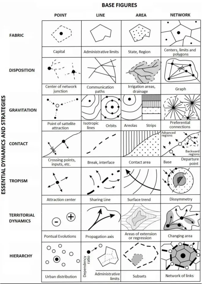
sense, according to Brunet’s argument, a chorem is not drawn; it is the referent itself, the object, the real. What happens is that models are constructed that strive to represent these structures. From these premises, Brunet proposes a framework with geographical igures (Figure 1), able to express these structures (Chorems).
His proposal, constructed as a system of signs to represent the chorems, is composed of the intersection of basic graphic elements (which correspond to the implementation modes) in columns, with the geographical dynamics in the lines. His suggestion does not have the same force of deter-mination as Graphic Semiology, where the sign is not arbitrary. The representations of the chorems are arbitrary, or can be made with variations by geographers. This set of representations, which can be improved, in practice covers the requirements of the cartographic expression of structures and geographical dynamics (2001, p. 198).
Just as Jacques Bertin worked to establish a system of signs that could act as a grammar for graphic language, Roger Brunet (2001, p. 196), sought to develop a territorial grammar also based on the concept of signs, with the suggestion of a system of signs that could express social processes and spatial dynamics. In his words, it is a “semiotic of space”. On the basis of the analogies used by Brunet to justify the need for a semiotic space with references to other forms of language, he resorts to the Greek root that refers to space to create the term chorem. For Brunet, the chorem is the lost link missing from the geographical theory of general space and places that undoes the classic contradiction between nomothetic and ideographic.
We can converge with Brunet regarding his argument that it makes no sense to construct gra-phical representations if they are not based on a theoretical and explanatory framework of spatial reality. Hence the author argues that one cannot know places (which he calls particular spaces), except by reference to general models, laws, rules, theories, concepts and even axioms (2001, p. 205). Similarly it is necessary to deepen the study of the particular structures of the fractions of space to ind the elementary space in general structures (the chorems). Through this exercise it would be possible to have a clear vision of structures and their signiicance to understand each particular space. For this reason, Brunet argued that it would make no sense to oppose the universal with the singular, as one cannot be understood without the other.
If “the Chorems are elementary structures of space, abstract by deinition” (BRUNET, 2001, p. 198), it can be concluded that their representation is an elaboration that the researcher constructs to interpret geographical reality. Thus, the meanings of the signs can also be changed to the same extent that the referent is changed. According to Matias (1996, p. 58), the best deinition of a sign was given by Charles Pierce, when he said that a sign can be understood as everything that exer-cises the function of representing something other than itself. That is, the function of the sign is to represent the referent. In Brunet’s case the referent is the chorem. It is the semantic investment given to his system of signs: the graphical models that represent the Chorems.
If for Bertin the relationships that matter are those internalized in the sign, that is, the rela-tionship between meaning and signiicant, for Brunet, what fundamentally matters is the relarela-tionship of signs (material representation) with the referents (the real). This is precisely the content clai-med by geographers to represent the dynamics and geographical concepts of the current period. If Bertin favored a map to look at that almost always has to be monothematic, for Brunet the map is fundamentally a map to read, whose representation is, in most cases, polythematic. Reaching an understanding of space as a totality involves letting go of the great efort to analyze various struc-tures jointly, to understand the movement of the whole.
47
Figure 1- Chorems proposed by R. Brunet
48
it is in Bertin. For this reason, its content leaves room for many discussions and various interpre-tations. An interesting seam can be found in chorematics regarding the extent that we can correlate spatial structures. It becomes possible to extract working hypotheses and guide the development of research, including pointing to the realization (and need for) ieldwork. Despite these objections, chorematics cannot be reached without irst passing through Graphic Semiology, to dissect each variable that makes up the structures.
According to Brunet, some structures are more visible in a space, inding others requires a more detailed examination. Thus:
The chorems, which are like the writing of the world, are represented by some key igures. They have to be learnt to understand the Geography of the world. These signs are like an alphabet for Geography because they permit the spatial forms produced by societies to be recorded. One part alone can match the visible traces of space. The landscape reveals some. To raise the complete language, the whole ield of possibilities realized, it is necessary to make an exhaustive examination of spatial distributions, even those of abstract values. (BRUNET, 2001, p. 197, our translation)
Thus, there would be both simple and complex structures, the latter requiring a more detailed analysis. Either way these categories are very similar to those proposed by Milton Santos (1985).
Here is the great challenge that few have dared to face. Certainly, Brunet’s construction is anchored in its conception of geographical space, which like all theoretical constructions is open to criticism and improvement. However, one must look beyond this and see the noteworthy efort made by this geographer to propose the Cartography which his analytical concerns required. Thus, his contributions seem fundamental to direct the discussion of a Geographic Cartography consistent with the spatial dynamics of the present.
Brunet stated, however, that this is not an easy task because with the interdependence of scale and the increasing complexity of the world everyday reality requires a daily additional efort of analysis.
The eminent French geographer recognized that the proposition of spatial graphical models is not new in Geography, as they have already been in use for a long time, as we have discussed above (MARTINUCI, 2009). However, there was not a previous efort to formalize its use supported by a theoretical justiication.
On the one hand, his proposal gained great notability in Europe in relation to territorial plan-ning and the education system, conirming its ability to foster the ability to establish interrelations and spatial syntheses in students (FERRAS, 1993; BONIN, 1975). The model developed by Brunet on European territorial dynamics is particularly famous. Its publication in the media earned it the nickname “blue banana” (BRUNET 2002, 2013). This is a map representing “the large backbone” or “megalopolis” that crosses Europe from Lancashire to Tuscany, where the highest population densities, the highest concentrations of big cities, the highest yields, highest added values per square kilometer and the most intense lows are found.
On the other hand they earned and still earn him strong criticism. One of the most notable was published by the famous French magazine Herodote (1995), directed by Yves Lacoste. Various arti-cles pointed to the political consequences in the context of regional planning and the incorporation of Roger Brunet’s ideas by geographers. The most notable fact, which seems to us fundamental, is precisely the important resonance that the proposition of chorems had, not only in academia, but also outside it.
49
In Brunet’s own words (2013): “Depuis, l’expression the consacrée été, y compris à l’étranger (nombreuses références sur internet) et surtout dans les milieux politiques d’aménagement et dé-veloppement local et regional”. The difusion of the chorems theory is due in part to Brunet’s close proximity to important French political igures. According to Lacoste (1997), the most signiicant was the Minister of Research, Jean Pierre Chevènement. Roger Brunet’s meeting with Chevène-ment in 1981 guaranteed the creation of a Maison de Géographie by Prime Minister Pierre Mauroy in 1982. Based in Montpellier, it is a strong research body, linked to the CNRS (National Center for Scientiic Research) and the GIP-RECLUS (Public Interest Group - Network for the study of changes in the locations and the spatial units). This allowed a gradual narrowing of relations with the INSEE (National Institute of Statistics and Economic Studies) and DATAR (Land Development and Regional Action Delegation), ensuring access to substantial inancial resources, public loans and private contracts. Furthermore, according to Lacoste (1995, p. 8) the proximity to state bodies permitted the dissemination of numerous GIP-Reclus publications.
Béatrice Giblin-Delvallet (1995, p. 34), in turn, criticizes the widespread use of chorematic representations between policies. She wrote:
Ainsi les élus des régions de l’est de la France ont-ils été ravis de s’appuyer sur la représentation de l’isolament de la métropole parisiense par rapport à la mégapole européene pour obtenir du gouvernement la décisión de réaliser le TGV. Est malgré sa très faible rentabilité.
There was also the spread of the use of chorems in secondary education. Lacoste (1995, p. 8) highlights:
C’est à partir du GIP-RECLUS est des réseaux qu’il noue pour tel ou tel contrat que va s’efectuer la difusion de la géographie chorématique e des idées de Roger Brunet, non seulement dans le personnel politique et dans le milieu des afaires, par l’entremise de la DATAR pour les questions d’aménagement du territoirem, mais aussi dans l’enseignement secondaire.
Unsurprisingly, the tone in which Yves Lacoste took issue with Brunet and his group was pre-cisely that of his famous work La géographie, ça sert, d’abord, à faire la guerre where he denounced the lack of controversy among geographers, which profoundly afected French Regional Geography.
The controversy raised by the group gathered around Lacoste, through the Hérodote maga-zine, with geographers gathered around Brunet and chorematics may indicate its possibilities and limitations in geographical research and teaching.
THE CARTOGRAPHIC TREATMENT OF GEOGRAPHICAL SPACE
As already noted, cartographic language has limitations, it is not itself the space. It is the repre-sentation of the referent that is much more complex, after all, the world is dynamic and structures change at diferent rates. Thus, it is not possible to represent everything that occurs in it.
50
Currently, we are facing a reality that challenges us to imagine projects for a better society, the possibility of which cannot be understood unless we understand the structures, how they work in a situation and how human lives are inluenced in this dialectical interplay between changes and permanence in locations. The consideration of the geographical situation (Silveira, 1999) can help us to understand how a territory functions, capturing life in ways that are understood on a map. From the analysis of the geographical situation we can understand the true meaning of objects, not for other things, but for the subjects. However, this is not fully possible without using Carto-graphy, which contributes greatly to this task, since the structures, the practical-inert compromises achieving a more just and fraternal future. In such an unequal country, whose territorial extension is striking, we must pay more attention to those places where the minimum conditions of existence are seriously compromised.
Despite the predominance of spaces of low that characterize the current world, in Brazil the extension is still a problem of human existence. Thus, extension and existence cannot be analyzed separately. It is necessary to overcome the view of Cartography as a hindrance to the development of Geography. We need to give forms new meaning and put Cartography at the service of a Geo-graphy concerned with the construction of citizenship.
FINAL CONSIDERATIONS
Milton Santos’ proposal of a method composed of four disjunctive but inseparable categories from the perspective of the totality may be the irst step in a successful work that passes through Bertin’s Cartography and Brunet’s Chorem. Especially in the latter, the ability to represent the processes (changes and continuities) inherent to forms, functions and structures is maximized. In this way, it would be possible to envisage a Cartography with form and content as intended by Ruy Moreira.
A geographical work conducted in this manner, that considers the space in its entirety and complexity, which passes through Graphic Semiology and through the chorems, can be very frui-tful in proposing questions and hypotheses for research, by correlating spatial elements in a simple structure, generating questioning and, lastly, guiding ieldwork. Thus, one must understand Carto-graphy not as a lesser task in the construction of geographical knowledge; instead, although it does not account for all the work, it is a fundamental part of it. Instead of requiring the reader to form mental images and schematic maps when we elaborate spatial arguments, why not assist them in this important task of unveiling the world by proposing representations that foster an eicacious understanding of the history of the present?
BIBLIOGRAPHIC REFERENCE
BARROS, M. V. F. et al. Londrina, la ville pionnière à la maturité. Revue Mappemonde, Toulouse, n. 73,
v. 1, 2004, p. 1-12.
BERTIN, J. Semiologie graphique. 4. ed. Paris: EHESS, 2005.
BERTIN, J. Ver ou ler: um novo olhar sobre a cartograia. Seleção de textos, AGB, São Paulo, v. 18, p.
45-62, 1988.
BERTIN, J. O teste de base da representação gráica. Revista Brasileira Geograia: Rio de Janeiro, n. 42,
v. 1, jan./mar; 1980, p. 160-182.
BONIN, S. Initiation a la graphique. Paris: Epi, 1975
BRUNET, R. Questions sur le bananne bleue. Disponível em <
http://www.mgm.fr/ARECLUS/page_au-teurs/Brunet14.html> Acesso em julho de 2013.
BRUNET, R. D’une erreur commune à propos de cartes et de modèles: comentaire sur le article de Patrick
51
BRUNET, R. Lignes de force de l’space européen. Mappemonde, v. 2, 2002, p. 14-19.
BRUNET, R. Le dechifrement du monde. Paris: Belin, 2001.
CATAO, R. C. Dengue no Brasil. Dissertação (Mestrado em Geograia). FCT/UNESP. Presidente Prudente,
2011.
DONDIS, D. A. Sintaxe da linguagem visual. 2. ed. São Paulo: Martins Fontes, 2003.
FERRAS, R. Les modèles graphiques en géographie. Paris/Montpellier. Economica/GIP Reclus, 1993.
FILHO, J. G. Gestalt do objeto: sistema de leitura visual da forma. São Paulo: Escrituras, 2000.
GIBLIN-DELVALLET, B. Les efets de discours du grand chorémateur et leurs conséquences politiques.
In: Herodote, Paris, v. 97, n. 76, p. 22-38, jan./mar. 1995.
GIRARDI, E. P. Atlas da questão agrária brasileira. Tese (Doutorado em Geograia). FCT/UNESP:
Pre-sidente Prudente, 2008.
GONÇALVES, A. de F. Avaliação de território e coremática. Dissertação (Mestrado em Geograia
Hu-mana). FFLCH/USP: São Paulo, 2012.
HARLEY, J. B. La nueva naturaleza de los mapas. Ciudad del México: FCE, 2005.
HEINZE, G; HUBRICH, C; HALFMANN, T. Stopped light and image storage by electromagnetically
in-duced transparency up to regime of une minute. Physical Revew Letters, v. 111, n. 3, jul. 2013.
Kitchin, Rob; Dodge, Martin. Rethinking maps. Progress In Human Geography, n. 31, v.3, p. 331-344, 2007.
KOEMAN, C. O princípio da comunicação na cartograia. Geocartograia (textos selecionados de
Car-tograia Teórica). USP: São Paulo, 1995.
KOLACNY, A. Informação cartográica. Geocartograia (textos selecionados de Cartograia Teórica).
USP: São Paulo, 1994 [1977].
KOSIK, K. Dialética do concreto. 5. ed. Rio de Janeiro: Paz e Terra, 1989.
LACOSTE, Y. A Geograia: isso serve em primeiro lugar para fazer a guerra. 14. ed. Papirus, 2008.
LACOSTE, Y. Les géographes, la science et l’illusion. Herodote, Paris, v. 97, n. 76, p. 3-21, jan./mar. 1995.
MACEACHREN, A. M; TAYLOR, D. R. F. Visualization in modern cartography. Oxford/New York:
Pergamon, 1994.
MARTINELLI, M. Mapas da geograia e cartograia temática. São Paulo: Contexto, 2006.
MARTINUCI, O. S. A compreensão geográica dos eventos em saúde no território brasileiro e a aná
-lise cartográica dos equipamentos de imagem-diagnóstico de alta complexidade. Tese (Doutorado em Geograia). FCT/UNESP: Presidente Prudente, 2013.
MARTINUCI, O. S. Da cartograia à coremática: representações espaciais para uma espacialidade mutante.
Mercator, Fortaleza, v. 8, n. 17, set./dez. 2009, p. 193-207.
MARTINUCI, O. S. Circuitos e modelos da desigualdade social intra-urbana. Dissertação (Mestrado
em Geograia). FCT/UNESP: Presidente Prudente, 2008.
MASSEY, D. Pelo espaço. Rio de Janeiro: Bertrand Brasil, 2008.
MATIAS, L. F. Por uma cartograia geográica: uma análise na representação gráica na geograia.
Dis-sertação (Mestrado em Geograia Humana). FFLCH/USP: São Paulo, 1996.
MOREIRA, R. Da região à rede e ao lugar: a nova realidade e o novo olhar geográico sobre o mundo. Revista etc...(Espaço, tempo e crítica), v. 1 (3), v.1, p. 55-70, 2007.
NETTO, J. T. C. Semiótica, informação e comunicação. São Paulo: Perspectiva, 2001.
PANIZZA, A. C; FOURNIER, J. O litoral do Rio Grande do Norte. Revue Conins, n. 3, 2008.
PETCHENIK, B. Cognição em cartograia. Geocartograia (textos selecionados de cartograia teórica).
FFLCH/USP: São Paulo, 1995.
PONCET, P. Quel fond de carte pour l’Australie?. Mappemonde, Toulouse, n. 74, v. 2, 2004.
52
RIBEIRO, A. C. T. Território usado e humanismo concreto. In: SILVA, C. A. Formas em crise: utopias
necessárias. Rio de Janeiro: Arquimedes, 2005. p. 93-111.
SANTOS, M. A natureza do espaço. São Paulo: Edusp, 2008f [1996].
SANTOS, M. Metamorfoses do espaço habitado. São Paulo: Edusp, 2008 [1988].
SANTOS, M. Espaço e método. São Paulo: Nobel, 1985.
SILVEIRA, M. L. O espaço geográico. Geousp, São Paulo, n. 19, p. 81-91, 2006.
SILVEIRA, M. L. Uma situação geográica. Revista Território, v. 4, n. 6, p. 21-28, jan./jun. 1999.
SLOCUM, T. A. Thematic cartography and visualization. New Jersey: Prentice Hall, 1999.
SUNAGAWA, W. Análise das relações entre as representação gráica da cartograia temática e do
design gráico. Dissertação (Geograia Física). FFLCH/USP. São Paulo, 2010.
THERY, H. Atlas do Brasil. 2. ed. São Paulo: Edusp, 2008.
THERY, H. Chaves para a leitura do território paulista. Revue Conins, n. 1, 2007.