UTILIZANDO EVIDÊNCIA DA WIKIPEDIA
RAFAEL ODON DE ALENCAR
UTILIZANDO EVIDÊNCIA DA WIKIPEDIA
PARA RELACIONAR TEXTOS A LUGARES
Dissertação apresentada ao Programa de Pós-Graduação em Ciência da Computação do Instituto de Ciências Exatas da Univer-sidade Federal de Minas Gerais como re-quisito parcial para a obtenção do grau de Mestre em Ciência da Computação.
Orientador: Clodoveu Augusto Davis Jr.
Belo Horizonte
RAFAEL ODON DE ALENCAR
USING EVIDENCE FROM WIKIPEDIA TO
RELATE TEXT TO PLACES
Dissertation presented to the Graduate Program in Computer Science of the Fed-eral University of Minas Gerais in partial fulfillment of the requirements for the de-gree of Master in Computer Science.
Advisor: Clodoveu Augusto Davis Jr.
Belo Horizonte
© 2011, Rafael Odon de Alencar. Todos os direitos reservados.
Alencar, Rafael Odon de
A368u Utilizando Evidência da Wikipedia para Relacionar Textos a Lugares / Rafael Odon de Alencar. — Belo Horizonte, 2011.
xxiv, 54 f. : il. ; 29cm
Dissertação (mestrado) — Universidade Federal de Minas Gerais. Departamento de Ciência da
Computação.
Orientador: Clodoveu Augusto Davis Jr.
1. Computação - Teses. 2. Sistemas de informação geográfica - Teses. 3. Sistemas de recuperação da informação - Teses. I.Orientador. II. Título.
I dedicate this work to everyone who deserves a high quality study, but unfairly has no chance to get it. In their honor, I hope to have fully accomplished it with my commitments.
Acknowledgments
First of all, I thank God who assured me health and peace so that I could fight for this project! I also thank my advisor Clodoveu Augusto Davis Jr for being such a great professional and person, demonstrating wisdom and patience especially in the last months. I thank my mates from the Database Laboratory for the living together, for the exchange of ideas, and for all the laughs and friendship which made it all worthwhile. I also thank my family for their affection and specially for the education and values that I’ve inherited from them. I thank my girlfriend Carolina for her continued support, trust, understanding and cumplicity!
“If you don’t make mistakes, you’re not working on hard enough problems. And that’s a big mistake.” (Frank Wilczek)
Resumo
Para obter resultados relacionados a lugares em sistemas de buscas, usuários geral-mente incluem termos geográficos nas consultas. Trabalhos anteriores mostram que consultas com intenção geográfica correspondem a uma parcela significativa da de-manda submetida a máquinas de busca. Dessa forma, é importante abordar o desafio da associação automática entre lugares e documentos a fim de responder adequada-mente a essas consultas. Esta dissertação descreve estratégias automáticas para a determinação do escopo geográfico de textos usando a Wikipedia como uma fonte de referências geográficas diretas e indiretas.
Em primeiro lugar, é proposto um método que utiliza evidências textuais da Wikipedia para classificar textos em lugares. São utilizados títulos de artigos e conexões entre os eles para estabelecer uma rede semântica que fornece informação para a classi-ficação. Experimentos com notícias classificadas nos estados brasileiros demonstrando o potencial e as limitações da da técnica. Outra proposta descreve uma estratégia para a marcação (tagging) de textos com múltiplos nomes de lugares. Dessa vez, utiliza-se uma técnica de identificação de tópicos (topic indexing) que considera os artigos da Wikipedia como um vocabulário controlado. Ao identificar esses tópicos no texto, conecta-se ele à rede semântica de artigos da Wikipedia, o que permite realizar oper-ações no grafo e encontrar lugares relacionados ao tema tratado. É apresentada uma avaliação experimental com documentos previamente marcados, demonstrando a via-bilidade da proposta e abrindo caminho para outras pesquisas em torno de geotagging baseado em redes semânticas.
Os resultados apresentados demonstram a viabilidade do uso da Wikipedia como uma fonte alternativa de referências geográficas. A principal vantagem do método proposto é o uso das informações livres, atualizadas e amplas da enciclopédia digital. Finalmente, considera-se que a introdução da Wikipedia na análise de elementos ge-ográficos de textos pode ser encarada tanto como uma alternativa quanto como uma extensão ao uso dos dicionários toponímicos (gazetteers) em tarefas de recuperação de informação geográfica.
Abstract
Obtaining or approximating a geographic location for search results often motivates users to include place names and other geography-related terms in their queries. Pre-vious work shows that queries that include geography-related terms correspond to a significant share of the users’ demand. Therefore, it is important to recognize the as-sociation of documents to places in order to adequately respond to such queries. This dissertation describes strategies for the geographic scope computation, using Wikipedia as an alternative source of direct and indirect geographic references.
First we propose to perform a text classification task on geography-related classes, using textual evidence extracted from Wikipedia. We use terms that correspond to ar-ticles titles and the connections between arar-ticles in Wikipedia’s graph to establish a se-mantic network from which classification features are generated. Results of experiments using a news data-set, classified over Brazilian states, show that such terms constitute a valid evidence set for the geographic classification of documents, and demonstrate the potential of this technique for text classification. Another proposal describes a strategy for tagging documents with multiple place names, according to the geographic context of their textual content, using a topic indexing technique that considers Wikipedia articles as a controlled vocabulary. By identifying those topics in the text, we connect documents with the Wikipedia semantic network of articles, allowing us to perform operations on Wikipedia’s graph and find related places. We present an experimental evaluation on documents tagged as Brazilian states, demonstrating the feasibility of our proposal and opening the way to further research on geotagging based on semantic networks.
Our results demonstrate the feasibility of using Wikipedia as an alternative source of geographical references. The method’s main advantage is the use of free, up-to-date and wide knowledge and information from the digital encyclopedia. Finally, the Wikipedia introduction to the geographic text analysis can be faced as both an alter-native and a extension to using geographical dictionaries (i. e. gazetteers).
List of Figures
1.1 Textual content example – a news article about victims of the September 11 terrorist attacks in New York City that fails to mention the city’s name 3
3.1 Example of Wikipedia geographic categories . . . 16
3.2 Example of an infobox from an Wikipedia article on Belo Horizonte city . 17 3.3 Wikipedia graph example . . . 22
3.4 Term weights in the inlinks and outlinks sets for each place . . . 22
3.5 Sample documents for classification . . . 23
3.6 Discovering places related to a wikified text in Wikipedia’s graph. . . 29
4.1 Accuracy versus training set sizes . . . 37
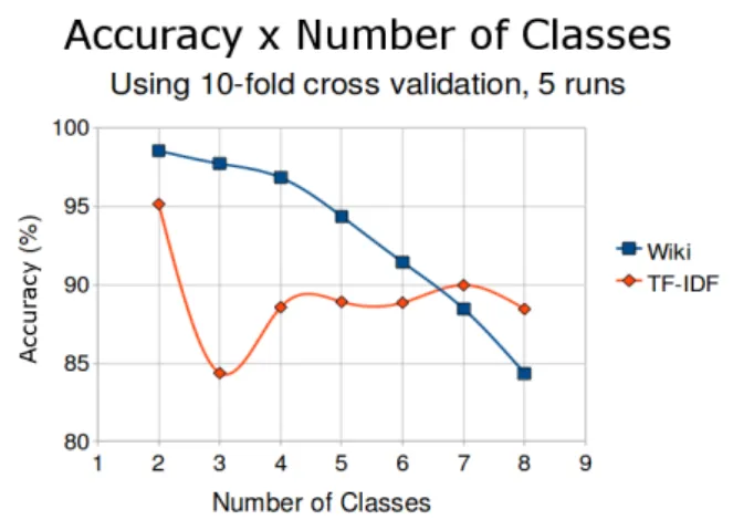
4.2 Average accuracy versus number of classes . . . 38
4.3 Geotagger performance for different exponential decay values for amaxdepth of 2 . . . 42
List of Tables
1.1 Direct and indirect geographic references found on September 11 news text (Figure 1.1). . . 4
3.1 Features in the first strategy, and calculated classes for each document. . . 23 3.2 Features in the second strategy and classification results . . . 24
4.1 Details about the test collection built with local news from each one of the 27 states from Brazil. . . 44 4.2 Accuracy for different training set sizes classifying the same test set . . . . 45 4.3 TF-IDF strategy average accuracy considering a varying number of classes 45 4.4 Wikipedia strategy average accuracy considering a varying number of classes 45 4.5 Acceptance and accuracy for different maxdepth levels. . . 45 4.6 Geotagger performance for different exponential decay values for amaxdepth
of 2 . . . 46
Contents
Acknowledgments xi
Resumo xv
Abstract xvii
List of Figures xix
List of Tables xxi
1 Introduction 1
1.1 Motivation . . . 1 1.2 Hypothesis . . . 5 1.3 Objectives . . . 5 1.4 Text Organization . . . 5
2 Related Work 7
2.1 Geographic Information Retrieval . . . 7 2.2 Geographic Context in Documents . . . 8 2.3 Wikipedia as a Source of Information and Knowledge . . . 10
3 Using Evidence from Wikipedia to Automatically Relate Texts to
Places 13
3.1 Wikipedia as Source of Geographic Evidence . . . 14 3.2 Strategy 1: Identifying Geographic Context through Classifiers with
Wikipedia . . . 18 3.3 Strategy 2: Identifying Geographic Context through Topic Indexing with
Wikipedia . . . 24 3.3.1 Defining a List of Target Places within Wikipedia . . . 26 3.3.2 Topic Indexing with Wikipedia . . . 26
3.3.3 Navigating in Wikipedia’s Graph to Discover Places . . . 28 3.3.4 Evaluating Certainty and Choosing Responses . . . 30
4 Experimental Evaluation 33
4.1 Building the Test Collection . . . 33 4.2 Results for the Classifier Strategy . . . 34 4.2.1 Baseline: Traditional Automatic Text Classification . . . 35 4.2.2 Experiments and Results . . . 36 4.3 Results for the Topic Indexing Strategy . . . 40 4.3.1 Search Depth Influence on Performance . . . 40 4.3.2 Manual Evaluation . . . 42
5 Conclusions and Future Work 47
References 51
Chapter 1
Introduction
1.1
Motivation
The last few decades brought us to an interesting time for research on data and in-formation management. Computer applications have been developed to help us with several activities. Meanwhile, mass storage devices got cheap and large, allowing those applications to ignore how much data they produce. Computer networks also have their share, especially the World Wide Web, since they make it possible to millions of users to act as producers and consumers of such information. These and other factors motivate advances on information retrieval. Keyword-based search engines such as Google1
, Yahoo!2
and Bing3
are widely used, and represent a billion-dollar business. But many challenges still exist. Taking into consideration the geographic meaning of keywords is one of them.
According to Wang et al. (2005), most human activities happen in a localized perspective, and that can also be reflected on the Internet. Previous works demonstrate that a large share of user queries on search engines have some geographic intention (Sanderson and Han, 2007; Delboni et al., 2007). Users often include place names and other geography-related terms in their queries, and keyword-based search engines could improve their results by considering the spatial dimension besides the classic keyword approach for query and document similarity (Baeza-Yates and Ribeiro-Neto, 1999). In order to deal with this challenge, we need to rely on some formal geographic annotation on web resources. However, we cannot expect that every retrievable resource will contain such metadata. This suggests the need for an automatic way to identify
1
http://www.google.com
2
http://www.yahoo.com
3
http://www.bing.com
2 Chapter 1. Introduction
the relation of Web pages to places.
Wang et al. (2005) consider three different ways to determine the geographic loca-tion(s) associated with a web document. First, it is possible to obtain an approximate location of the Web server, as informed by services that relate an IP address to a pair of coordinates, such as GeoIP4
. Second, the location can be inferred by looking at con-centrations of users that access the document and their IP-determined locations, or by the location of documents that refer to it. Third, the location can be inferred by an-alyzing the textual content of the document. All three aspects have their importance, but we are particularly interested in the last one. Notice that the geographic scope of the textual content can be totally different from the place where the document is served. Also, the location of visitors could be biased, since content providers can be more popular in specific places. For instance, imagine a news website from a Brazilian news agency located in United States of America, hosting its website in a European web server, and posting news about a fact in China. Much of the geography present in this complex example is not relevant for those who are only interested in Chinese facts, and we should consider that, in a globalized perspective, relevant information can come from anywhere. Since most of the information on the Internet is written down as natural language text, we also consider that textual analysis is a rich field of possibilities.
Much recent work follows this direction, with subjects such as the identification of geographic context in Web documents or the association of place names to Web pages (Jones et al., 2008; Schockaert et al., 2008; Silva et al., 2006) or simply geotag-ging/geoparsing (Amitay et al., 2004; Guillén, 2008). Successfully accomplishing this task enables us to associate places to online content, giving us means to enhance current indexing and retrieval mechanisms, so that people can search for textual content that fall within a delimited geographic scope (i.e. perform local search (Himmelstein, 2005; Schockaert et al., 2008)), or even filter content based on regional interests. Service providers would be able to perform geographically-focused advertising and to develop novel ranking strategies for search engines.
In practice, to geoparse content, three basic activities must be performed: iden-tify place names candidates in the text; disambiguate them, since they can refer to multiple places or even to non-geographic entities; and finally assign a localization to the references, such as latitude and longitude coordinates (Amitay et al., 2004; Zong et al., 2005). In this case, gazetteers play the role of geographical dictionaries used as a source of official and alternative place names, mapped to a geographic infrastructure
4
1.1. Motivation 3
(i.e. points, lines and polygons described with coordinates) (Machado et al., 2010). This place name recognition approach can be very useful to find direct references in texts, but sometimes we must consider also the presence of indirect references.
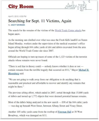
Indirect references can lead us to infer the relation of the text with unmentioned places. Figure 1.1 is a news related to victims of the September 11 terrorist attack in New York. Curiously, the city name “New York” is never mentioned in the text. Although it seems quite easy for human readers to find out the text relation to New York, this task can be not so simple for computers.
Figure 1.1. Textual content example – a news article about victims of the September 11 terrorist attacks in New York City that fails to mention the city’s name
non-4 Chapter 1. Introduction
# Reference Description
1 Staten Island Neighborhood
2 West Street Street
3 Albany Street Street
4 Vesey Street Street
5 West Broadway Street
6 World Trade Center Building
7 Fiterman Hall Building
8 Fresh Kills Landfill Landfill 9 Michael R. Bloomberg Mayor
10 Sept. 11 Date
11 9/11 Date
12 Terrorist Attacks Topic
Table 1.1. Direct and indirect geographic references found on September 11 news text (Figure 1.1).
trivial geographic references could be fetched from third-party Knowledge Bases (KB). By exploring the KB’s semantic capabilities we can try to make computers understand the relation among places and several types of topics. Since it is also important to keep information information up-to-date, this KB should also be constantly enriched and evaluated.
Recent works have shown that Wikipedia5
can play the role of a Knowledge Base (Kasneci et al., 2009). Wikipedia is an online encyclopedia to which any visitor can contribute. Its pages represent concepts, and the hyperlinks among them allow users to navigate and explore a rich network of topics. Pages can be organized in categories, helping to group and list concepts in common branches of knowledge. Important struc-tures present in the pages’ source code can be used to gather domain specific informa-tion (e.g. retrieve the current mayor’s name in cities pages). Also, the text used to explain the concepts in each page is a rich source of expressions and terms to feed both natural language processing tasks and probabilistic models for automatic text analy-sis. Such features suggests that Wikipedia can be used, by itself or along with official gazetteers, to improve the identification of direct and indirect geographic references in text. Wikipedia is also a good source for geographic knowledge because it is available in multiple languages, thus allowing the development of language-independent tech-niques. It is constructed and maintained by a large community interested in keeping information up-to-date. Therefore it is an suitable candidate for supplying semantic knowledge to information retrieval.
5
1.2. Hypothesis 5
1.2
Hypothesis
In this work, we explore the hypothesis that it is possible to use Wikipedia as an alter-native source of geographic evidence to help dealing with the problem of automatically associating places to texts.
1.3
Objectives
In order to verify the hypothesis, we pursue two ideas in this dissertation. First, we formulate the location recognition problem as a classification problem, and propose a solution based on machine learning which uses Wikipedia contents to generate features that describe the presence of keywords associated to places in texts. Second, we use a topic indexing technique to discover relevant Wikipedia pages as topics in text.
In the first approach, a classifier must decide whether a text is more likely re-lated to a certain place than to others, based on supplied training data, thus choosing a predominant geographic scope. The second approach intends to achieve a direct con-nection between terms and expressions found in text and the Wikipedia’s network of topics. We then investigate if this network can provide enough information to build a list of directly and indirectly related places.
1.4
Text Organization
Chapter 2
Related Work
2.1
Geographic Information Retrieval
The field of Information Retrieval (IR) comprehends problems on how to store and access information items, in such a way that users can query this information. Given the user needs, expressed through queries, the aim of IR systems is to process this input and to decide whether some information is useful or relevant, in order to retrieve it back to the user. Differently from Data Retrieval, which relies on well defined algorithms and data structures to allow user to exactly specify the characteristics of what he needs, IR techniques are more vague and deal mostly with natural language instead of structured data. Considering this, different strategies must be applied to approximate the user’s query intention to retrievable information. The results must be ranked by their relevance, and this relevance analysis is considered to be the center of the IR field (Baeza-Yates and Ribeiro-Neto, 1999). With the growth of the World Wide Web, IR became an important discipline, since search engines became necessary to help users find relevant content on a giant network of Web pages.
Applying IR to geo referenced information (i.e. information associated to spa-tial descriptors such as latitude and longitude coordinates) introduces the concept of Geographic Information Retrieval (GIR). The Alexandria Digital Library project1
is a classic example of a large collection of geo referenced materials (Smith and Frew, 1995) in which GIR was naturally required. More than just developing means to accumulate information, it was fundamental for the project to have a useful interface, including support to text-based queries. This allows users to retrieve information on what exists somewhere or where something is located, according to a variety of constraints.
1
http://www.alexandria.ucsb.edu/
8 Chapter 2. Related Work
Zhu et al. (1999) claim that the development of effective GIR techniques is one of the most challenging research issues for geospatial collections, since user queries are based on concepts and fuzzy terms, expressed by natural language. According to them, GIR systems should be able to answer two classic spatial queries: “What’s there?" and “Where’s that?". To to this, it is necessary to describe geographic locations using both its coordinates and a set of names and textual features. Querying this textual content is a classical vocabulary problem, requiring the use of dictionaries, string matching algorithms, and toponym (place name) resolution in text (Leidner, 2007).
We must consider that some collections of information can contain items with no explicit geo references, but these items can contain information that is somehow related to some location. That is the case of the World Wide Web. Ding et al. (2000) state that a Web resource has a target audience, and this audience can be geographically enclosed. Considering this, they introduce the concept of geographical scope, which should point to the geographic distribution of such audience. According to them, this geographic scope is subjective, as much as relevance is to IR, since it depends on the user’s expectation and how well his intention can be expressed when querying the search engine. They propose a geographically-aware search engine, using estimation algorithms based on Web page content and HTML link information to automatically compute the geographic scope of Web pages.
2.2
Geographic Context in Documents
2.2. Geographic Context in Documents 9
are often allocated in an ad-hoc fashion, and that can cause an erroneous connection between an IP address and its physical location. Furthermore, even though a website can be served in some country, it does not mean its content is limited to the the same locality.
Gravano et al. (2003) say that Web pages can be characterized as global or local, considering the interest of users in their content. But, unfortunately, at that time, search engines did not perform any kind of analysis on the geographic locality of queries and users, producing sub-optimal results. They propose a method to categorize queries according to their geographic locality, by considering two possible classes: global or local. They mention that such locality can often be implicit. Their proposal is based on machine learning tools, which use classifiers over a sample of queries from a real Web search engine, indicating the importance of further research about the geographic aspect of keyword search.
We already mentioned in Chapter 1 that Wang et al. (2005) categorize previous initiatives on GIR applied to Web pages into three main approaches. First, it is possible to obtain an approximate location of the Web server, as informed by services that relate an IP address to a pair of coordinates. Second, the location is inferred by looking at concentrations of users that access the document and their IP-determined locations, or by the location of documents that refer to it. Third, the location can be inferred by analyzing the textual content of the document. As previously discussed, this dissertation works with the last type, since the location of the Web server can be completely unrelated to the subject of the document and the IP locating techniques are, sometimes, error-prone and imprecise.
Borges et al. (2007) show that there can be many indications of geographic loca-tion in Web documents, but not all pages include unambiguous and easily recognizable evidence such as postal codes or telephone area codes. In that work, an ontology-based approach is presented for recognizing geographic evidence, including postal addresses and their components. Some other works have also focused on identifying the geo-graphic context of Web pages by obtaining references to place names or data such as postal addresses, postal codes, or telephone numbers (Ahlers and Boll, 2008; Blessing et al., 2007; Witten and Frank, 2000), then performing some sort of geocoding (Davis Jr and Fonseca, 2007).
10 Chapter 2. Related Work
a graph-based approach akin to PageRank (Brin and Page, 1998) to associate scopes to documents, based on a geographic knowledge repository. Such a knowledge base is essential for the process, since it contains information such as place names, postal codes, and even historical names, as provided by TGN, the Getty Thesaurus of Geographic Names2
(a gazetteer).
Beyond the recognition of place names, we observe that many other terms that can occur in a text can be related to places as well. For instance, terms associated to historical events, monuments, commercial activities, names of authorities, sports teams and others can provide clear indications of geographic location, as long as the semantic connection between the term and the place can be somehow established. Such terms might be used either to establish a location or to disambiguate places that share the same name. The feasibility of this idea was explored by Backstrom et al. (2008), who present a model to track spatial variation in search queries, showing the geographic concentration of the origin of queries related to sports teams. Cardoso et al. (2008) call these terms implicit geographic evidence.
Considering the works mentioned in this section, we notice that methods for the geographic scope computation can be improved by the proposal of semantic-based approaches. The introduction of knowledge from other sources in the place names recognition can point to new challenges, and that is when Wikipedia starts to play an important role, as described in next section.
2.3
Wikipedia as a Source of Information and
Knowledge
Recent work has shown that Wikipedia can be a valuable source of information, con-sidering the semi-structured annotations that exist in its entries and the usual richness of articles links, which compose a de facto semantic network. Kasneci et al. (2009) present their approach to developing and maintaining a knowledge base called YAGO (Yet Another Great Ontology), for which knowledge sources are Wikipedia’s infoboxes (sections containing attribute-value pairs) and categorical lists, enriched and automat-ically interpreted with the aid of WordNet3
.
Cardoso et al. (2008) also use Wikipedia to experiment with named entity recog-nition, and present a system that can find implicit geographic references, such as deter-mining that a text refers to New York City from the expression “Empire State Building”.
2
http://www.getty.edu/research/tools/vocabularies/tgn/
3
2.3. Wikipedia as a Source of Information and Knowledge 11
Buscaldi (2009) use the Wikipedia as a rich source of geographical evidence and pro-pose to build a geographical ontology considering geo-political entities found in the encyclopedia’s entries. In another work, Buscaldi and Rosso (2007) compare different methods to automatic identify geographical articles in Wikipedia.
Machado et al. (2010) present an ontological gazetteer (geographic dictionary) called OntoGazetteer, which goes further the traditional cataloging of place names and includes geographic elements such as spatial relationships, concepts and terms related to places. Wikipedia is used to provide lists of keywords and expressions associated to places, which allows to take advantage of the gazetteer structure to improve geographic information retrieval tasks such as the disambiguation of place names in texts.
Chapter 3
Using Evidence from Wikipedia to
Automatically Relate Texts to
Places
We have already mentioned in Chapter 1 and 2 that automatic applications can look for references in texts to try to capture their geographic scope. While place names are the most common element used to do so, we consider the place name to be just one of the many clues to identify the relationship between a text and a set of places. Places have characteristics such as their history, culture, social activity, economy, sports, food, folklore, arts and many others. All of those can help to decide which places are referenced by the text. Also, people are naturally bound to places, such as the city they are from, where they live and where they work. For instance, if the name of a celebrity or a public figure is mentioned in the news, we can enumerate a list of possible places related to that news. Basically, since everything exists or happens sometime and somewhere, it is quite obvious that a fact or entity will be always linked to one or more places. We should consider all of these other references as indirect evidence of the relationship between entities and places.
Just as place names need to be listed by a dictionary (a gazetteer) in order to be recognized as such in a text, indirect evidence also need some technological support to be identified. We suggest two approaches. The first one is to start with a list of target places and then list indirect evidence related to each one of them in the form of textual expressions. These expressions can be matched in text the same way we match place names. To do this, we need a good source of place-related expressions. The second approach is to use a Knowledge Base (KB) to help understand the relationship between concepts and places. Once we identify some concepts in the text, we need
14
Chapter 3. Using Evidence from Wikipedia to Automatically Relate Texts to Places
ways to explore a concept network and decide which places are the most related to the text contents.
In both cases, we see Wikipedia as a suitable alternative to our proposal, since it contains a lot of textual content to be used as a source of expressions, and it also contains a network of pages connected by links, making it possible to explore the relationships between concepts. In the next sections we explain how Wikipedia can be used to automatically gather information, and the benefits of choosing the digital encyclopedia as an alternative Knowledge Base (secio 3.1). Then we present both approaches to use Wikipedia to aid the automatic identification of geographic scope in texts, one based in place-related expressions (section 3.2) and the other based on the exploration of the concept network (section 3.3).
3.1
Wikipedia as Source of Geographic Evidence
Wikipedia1
stands out as a successful example of how a billion-user network can build something hugely useful in a collaborative way, what is called crowdsourcing. By allowing its visitors to create, edit and revise any article, something called a wiki system, the digital open encyclopedia has become a very popular reference in the search for concepts on several subjects. While “gathering of all world knowledge” sounds like a pretentious goal, the website’s success relies on the fact that the available content is being constantly scrutinized by million of altruistic users. Their efforts are clearly visible by the huge amount of revision that the existing articles undergo and how fast such revisions occur. According to the Wikimedia Statistics2
on May 31, 2010, the English version of Wikipedia is the largest one with more than 3 million articles, more than 7 million views per hour, and an average of 23 revisions per article a month. Although the number of new articles seems to be getting stable, the website’s popularity shows to be increasing along the time, which helps to keep the collaborative philosophy in the validation and enrichment of the encyclopedia’s content.
With this constant refinement of the Wikipedia articles, there are some interest-ing initiatives from the community. Many of the projects proposed by users aim to normalize articles within a common domain (e.g. articles about countries, list of pres-idents, music groups by genre), trying to guarantee a common structure and minimal quality level in an article. To do this, they try to better wikify the text (including proper links from and to other articles) and to maintain a regular topic structure for
1
Wikipedia - http://www.wikipedia.org/
2
3.1. Wikipedia as Source of Geographic Evidence 15
similar concepts. They also include articles on their expected categories and insert useful code templates.
The categories are used to organize the articles in groups according to the branches of knowledge they belong to, and they can also have sub-categories. Such a feature allows to navigate over a taxonomy, looking for correlated concepts that share some property (e. g., people who were born in a certain year). Considering the Belo Horizonte city article in the Portuguese Wikipedia3
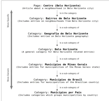
, it is categorized inside a “Belo Horizonte” branch, which includes other articles about the city. On the other hand, this branch is listed under “Capitais do Brasil” (Capitals of Brazil), “Municípios de Minas Gerais” (Municipalities of Minas Gerais state) and “Cidades Planejadas” (Planned Cities). By exploring the Municipalities of Minas Gerais state category, we can find other sub-categories about important cities on this state. This category is also further categorized inside a more general category called “Municípios do Brasil” (Municipalities of Brazil), which includes links to categories of other groups of munici-palities for each one of the 27 Brazilian states. If we continue doing this, exploring the categories of categories, we naturally get to more general levels, which allows to find articles on the whole world geography. Figure 3.1 illustrates this possibility with an example of Wikipedia’s geographic categories hierarchy, starting from an article about a neighborhood in Belo Horizonte city, and reaching a very general category about municipalities of the world.
We consider the categorization structure an important aspect of Wikipedia if one decides to use the digital encyclopedia as a source of geographic evidence. The exploration categories can suggest automatic or at least semi-supervised strategies to create a list of target places considered in the geographic scope computation. Without those geographic categories, the search for place-related articles would have to be done manually, by determining which Wikipedia page corresponds to each of the known places, probably with the help of Wikipedia search tool.
Code templates help to enrich the text with data in a specific format that can be parsed by the Wikimedia system. One of the most useful templates applied in common domain articles is a table of attribute-value pair called infobox (Figure 3.2). Every article from a music band, for example, may include an infobox with the band’s name, members, year of foundation, style, and so on. Since a lot of articles include infoboxes in their content, infobox is a powerful tool that helps the development of automatic mining tools over the Wikipedia content. Place related articles have their specific infoboxes. Figure 3.2 shows an adapted infobox from the English Wikipedia
3
16
Chapter 3. Using Evidence from Wikipedia to Automatically Relate Texts to Places
Figure 3.1. Example of Wikipedia geographic categories starting from an article about a neighborhood and reaching the categories on the World municipalities
article about Belo Horizonte. The left side of the figure shows the layout of an infobox, while the right side shows the code template used to create it. The attribute-value pairs contain information on the city name, nicknames, relation to other places, area, population and other relevant aspects.
We also consider infoboxes useful structures in the geographic analysis of Wikipedia content. They allow automatic applications to simply extract expected complex information, such as which state a city is subordinated to based on their reg-ular structure. Since infoboxes follow a predefined code structure, they can be easily parsed. This information extraction can help applications to ensure they are analyzing the right article. For instance, when an automatic method finds the Belo Horizonte article, according to Figure 3.2, it can check if there is an infobox of the type “ settle-ment”, and then check if the “Name” value is equals “Belo Horizonte”, increasing the certainty that the article is really about Belo Horizonte.
3.1. Wikipedia as Source of Geographic Evidence 17
Figure 3.2. An example of infobox code template for Belo Horizonte adapted from the English Wikipedia article. On the left its layout and on the right its code template, revealing the attribute-value pairs.
18
Chapter 3. Using Evidence from Wikipedia to Automatically Relate Texts to Places
concept name can vary according to the context in which it is mentioned.
If we can identify place-related articles in Wikipedia, regardless of how we do it, using Wikipedia as a source of terms and expressions associated to places becomes fea-sible. One can assume that Wikipedia nowadays contemplates a large set of geography-related articles containing infoboxes and organized in relevant categories. Specifically in the Portuguese Wikipedia, there are some existing community projects that focus on editing place-related articles (e. g., about cities, states, neighborhoods) creating specific infoboxes full of useful geographic aspects in each of them, and even adding alternative code templates such as Latitude and Longitude coordinates. These efforts suggest that Wikipedia can be used as a source of geographic evidence, at least for popular places. Some less popular places can have no entry in Wikipedia, which may be an obstacle. But we consider that if these places are so irrelevant that they were not listed in Wikipedia, they will probably also be irrelevant for the geographic scope computation on the Web.
Regarding Wikipedia’s information quality, such content includes a lot of noise or even missing information for every article. It is not possible to ensure the information accuracy from the educational perspective. But since Wikipedia has millions of articles, it opens possibilities to develop techniques which rely on its statistical importance more than on its conceptual correctness.
3.2
Strategy 1: Identifying Geographic Context
through Classifiers with Wikipedia
For this first strategy, we want to demonstrate that Wikipedia can offer textual clues to analyze texts and help in the determination of their geographic scope. To accomplish this goal, we start with a simpler problem in which the expected output is a single place name, for the place that best represents the document’s scope. Then, we propose to use an automatic classification approach. Basically, we define a set of places P to be our classes, and propose a process to decide which class is more closely related to a sample text.
3.2. Strategy 1: Identifying Geographic Context through Classifiers
with Wikipedia 19
section 3.1, in which there are ni representing pages, and an edge eij obtained from textual hyperlinks connecting nodeni to nodenj. As explained earlier, the connections around a node in this directed graph can be separated in two sets: inlinks and outlinks. The title of the page represented by the counterpart node in those links represents the set of relevant terms for each place.
In order to put the graph together, we downloaded a MySQL dump of the pages and pagelinks tables of the Portuguese version of the encyclopedia, obtained in Wiki-media’s downloads page on November 11, 2009. The pages table contains the pages themselves, including attributes such as an identifier, title, and namespace (type). The pagelinks table stores the connections between pages. We used the titles of entries that are adjacent to a page about some place of interest as a set of names relevant to identifying text about that place. For instance, the “Rio de Janeiro” (Brazilian state) entry includes links to pages titled “Samba” (the dance), “Carnaval” (a popular festiv-ity), and “2016 Olympics” (an upcoming event). These titles are then included in the outlinks set. Furthermore, pages titled “French invasion” (an historical event), “Sugar Loaf” (a landmark), and “Southeast region” (a Brazilian region that includes Rio de Janeiro state), include links to the “Rio de Janeiro” entry, and are added to the inlinks set.
We consider the inlinks and outlinks to have different meanings, and potentially different values for the classification. Outlinks are found in the place entry text, thus covering names that are important for someone interested in the place. On the other hand, inlinks are links found in other entries that refer to the place, thus covering names of entries for which the place is important.
Comparing the inlinks and outlinks term sets related with each place in P, it is expected that some terms occur in relation with more than one place. The terms that are related to a smaller number of places inP are considered to be more discriminative than others that relate to many places. For instance, the term “Southeast region” relates not only to “Rio de Janeiro”, but also to “Minas Gerais”, “Espírito Santo” and “São Paulo”, the other states in the same region, and can occur both in the inlinks and in the outlinks sets of each of these states.
To work with automatic text classification, we have to represent each text as an array of features represented by numeric values. A basic approach would be to define those features as binary values indicating the presence or absence of some words or terms from a vocabulary. Advancing this model, we can also define those features as words frequency, giving more information for the classification algorithm.
20
Chapter 3. Using Evidence from Wikipedia to Automatically Relate Texts to Places
from P adjacent to the term t in the graph is divided by m, the total number of places considered as classes. This ratio is then normalized and squared, so that less discriminative terms get a weight that is close to zero, while more specific terms get weights closer to the maximum of one. For instance, if we use the set of 27 Brazilian states as our target classes, a termt1 that is related to a single state obtains a weight
w(t1) = 1.0, while a term t2 that is related to 26 of the 27 states getsw(t2) = 0.0054. Equation 3.1 shows the formula for w(t), in which adj(t) represents the number of places from P that are adjacent to the term t in the graph. Naturally, the value of
adj(t) is at least 1, since t only makes part of the list of terms if it is found in at least one link from or to a place in the Wikipedia graph.
w(t) = 1−adj(t)−1
m
!2
(3.1)
A basic classification strategy would determine the frequency of the terms in the text, and perform a weighted sum usingw(t). The place that reaches the highest total would be the result of the classification. However, in a preliminary manual investi-gation, we verified that this simple strategy could produce many distortions. First, no distinction between terms from inlinks and from outlinks could be made. Second, some places could be penalized in the classification, because of their lower popularity or because of a less detailed Wikipedia entry. New normalization schemes would then be necessary, potentially leading to difficulties in the analysis and generalization of the results.
To overcome this problem, we used the Multinomial Naïve Bayes automatic clas-sifier, known for obtaining good results in text classification using a representation based on the frequency of a given set of terms (McCallum and Nigam, 1998). The Naïve Bayes classifier operates by adjusting a model that calculates the probability of a class to generate an instance considering the presence of features in the examples. It considers each feature to be independent of the others, which is a naïve assumption, but which in practice simplifies the learning process while still generating good results. The multinomial variation of this classifier is widely used in text classification and it assumes that features represent the frequency of terms, ignoring the position of the terms in the text and only observing their occurrence (McCallum and Nigam, 1998).
The idea is to let the classifier adjust itself to the combination of quantitative information on the occurrence of terms from the Wikipedia in the text. Weighted sums
3.2. Strategy 1: Identifying Geographic Context through Classifiers
with Wikipedia 21
feature corresponding to a given place (pi) and document(di) association.
Sin(pi, dj) =
|in| X
k=1
(w(tk)×F requency(tk, dj)) (3.2)
Sout(pi, dj) =
|out| X
k=1
(w(tk)×F requency(tk, dj)) (3.3)
By using the idea of two separate weighted sums for each place, a first classifica-tion model was then produced. In this model, a term with a highw(t)adds significantly to the sum, while terms with low weights can also contribute to the result, but with a smaller impact. We generate 2m features per document in the collection, i.e., twice the number of places in P. Each of these features represents the relationship between a list of terms from Wikipedia (from the inlinks or from the outlinks sets) and a doc-ument. With that information, the classifier is expected to find the best fit between each document and a place from P.
Since we are also motivated to use machine learning classifiers in order to fine tune a frequency-based information model, we decided to improve the proposed classification model to generate a second version, using more detailed features. Our hypothesis was that adding more features to the model could increase the possibilities for the classifier to adjust itself to the model. Thus, we exploded the two weighted sums for each place into 2m weighted sums. Each set of terms (from the inlinks and outlinks) is divided intomsets, one for each possible value ofadj(t). With this, we obtainmweighted sums corresponding to groups of terms with equal discriminative capacity. Therefore, we put together a feature set consisting of 2m sums for each place in P, i.e., 2m2 features per document.
As an example of this second classification model, consider a simplified version of Wikipedia’s graph, including entries on two Brazilian states (Figure 3.3). The inlinks and outlinks are obtained from the text of the entries, and then weights are calculated according to Equation 3.1 (Figure 3.4).
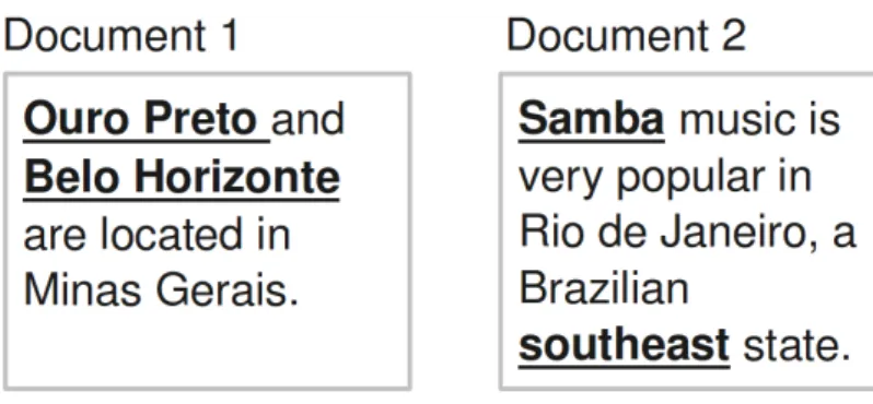
For the classification, consider the documents shown in Figure 3.5. The terms that occur in either the inlinks or the outlinks sets for each place are underlined. Some terms, such as “Southeast”, appear in more than one list, for more than one state, and therefore are less discriminative when they appear in a document.
22
Chapter 3. Using Evidence from Wikipedia to Automatically Relate Texts to Places
Figure 3.3. Wikipedia graph example
3.2. Strategy 1: Identifying Geographic Context through Classifiers
with Wikipedia 23
Figure 3.5. Sample documents for classification
Documents Minas Gerais Rio de Janeiro Class
in out in out
Document 1 2 1 0 0 Minas Gerais
Document 2 0.25 0.25 1.25 1.25 Rio de Janeiro
Table 3.1. Features in the first strategy, and calculated classes for each docu-ment.
classifier uses these features to decide on a class for each document. In the example, document 1 is classified as “Minas Gerais”, and document 2 as “Rio de Janeiro”. The mention to “Southeast” in document 2 generates the 0.25 values in the features associ-ated to Minas Gerais, but the same happens in relation to Rio de Janeiro. The results for document 2 are more decisively influenced by the occurrence of “Samba”, a term that has been exclusively associated to Rio de Janeiro.
In the second classification model, terms are split in groups according to their
adj(t)value, which indicates how specific each term is. Since there are only two states,
adj(t) can be either 1 or 2: “Ouro Preto” and “Samba” have adj(t) = 1, while “South-east” has adj(t) = 2. The weighted sum calculations are now performed separately for each group of terms with the same adj(t) value. Table 3.2 shows the results for the example. Notice that the 1.25 value for the inlinks to Rio de Janeiro was split into a in1 value of 1.0, corresponding to “Samba”, and a in2 value of 0.25, obtained from “Southeast”. Considering such division of terms into groups, the calculation of the features still follows Equations 3.2 and 3.3, but this time the summation is performed over groups of terms that have the same discriminative power.
24
Chapter 3. Using Evidence from Wikipedia to Automatically Relate Texts to Places
Documents Minas Gerais Rio de Janeiro Class
in1 in2 out1 out2 in1 in2 out1 out2
Document 1 2 0 1 0 0 0 0 0 Minas Gerais
Document 2 0 0.25 0 0.25 1 0.25 0 0.25 Rio de Janeiro
Table 3.2. Features in the second strategy and classification results
validation (Witten and Frank, 2000) set of tests). With the second and more detailed classification model, the Multinomial Naïve Bayes classifier reached an average preci-sion rate of 98.0% with 10-fold cross validation. The improved precipreci-sion shows that having more evidence to support the classification can lead to better results, as ex-pected. In the results section we show a larger experiment on this strategy, involving a larger collection and a larger number of classes, and a comparison to a text classification that uses no geographic evidence from Wikipedia as a baseline.
We can see that Wikipedia can be used as a source of terms for the geographic scope computation, but as the results will show in section 4.2, the representations of features as terms frequency and the machine learning approach can face difficulties, specially regarding the scalability when considering a huge number of classes. This motivates us to propose the next section strategy which, among other benefits, is not based on machine learning.
3.3
Strategy 2: Identifying Geographic Context
through Topic Indexing with Wikipedia
3.3. Strategy 2: Identifying Geographic Context through Topic
Indexing with Wikipedia 25
evidence of their relationship to any place.
Our proposal consists in the steps that follow:
• Defining a list of target places within Wikipedia: Our method needs to
know a list of places that are expected to be used as tags. Those places must have their Wikipedia articles identified. As we explained in section 3.1, Wikipedia offers some features that make it possible to perform mining for places, such as the categories system. Some works in the literature focus specifically on this task (Buscaldi and Rosso, 2007; Buscaldi, 2009).
• Topic Indexing with Wikipedia: In order to connect a text document with
Wikipedia’s semantic network, a topic indexing algorithm must be applied, con-sidering as a controlled vocabulary the titles of articles from Wikipedia. Such a mechanism also must offer high precision and be prepared for disambiguation, since some portions of the text can be used to refer to more than one article. We apply the methods presented by Medelyan et al. (2008) and by Milne and Witten (2008).
• Navigating in Wikipedia’s graph to discover places: By identifying a
subset of Wikipedia articles as topics from the text, we can consider the evaluated document as a new node on the encyclopedia’s graph. The whole set of articles from Wikipedia compose the other nodes from this graph, while the internal links between each one of them give us the edges. We propose to perform a breadth-first search on this graph, starting from the new node (the text). Thus, we can meet some of the target places listed before in this search, an then we can calculate their semantic distance to our start node and their relevance in the network. This step will generate a list of candidate places.
• Evaluating certainty and choosing responses: Given a list of candidate
places, we must evaluate if there’s enough information to choose one of them as a geographic tag for the document. A rate threshold can be used to choose the best place from the list, but in some cases the ratings of the places can be too similar, characterizing a confusing state. Many different approaches can be tested in this step in a experimental way.
26
Chapter 3. Using Evidence from Wikipedia to Automatically Relate Texts to Places
3.3.1
Defining a List of Target Places within Wikipedia
Considering the rich geographic content offered by recent releases of the Wikipedia, it is possible to conceiveg some strategies to define a list of target places to be used in the geotagging process. In the case of Brazilian places, it was possible to manually navigate through the categories system looking for those that list only geographic entities, such as Brazilian states, cities in a state, micro-regions from a state, and even more detailed categories such as city neighborhoods and boroughs. This hierarchical organization allows to write scripts to gather all entities listed from each one of these categories, creating a kind of alternative gazetteer in which entities are linked to Wikipedia arti-cles. To avoid listing entries that do not correspond to places during this automatic collection, it is also possible to parse the content of each one of them, trying to find infoboxes that help to determine whether the entry’s content is really about the desired type of place.
For our experimental evaluation in this paper, we have considered only Brazilian cities and states. After collecting all of them, we compared the number of cities per state with a official list of from the Brazilian Institute of Geography and Statistics (IBGE). We were able to cover 5514 cities, that is about 99% of the 5561 existing ones.
3.3.2
Topic Indexing with Wikipedia
Medelyan et al. (2008) described a method to identify topics in text using Wikipedia articles as a controlled vocabulary and a source of statistics concerning anchor texts that are used to refer to certain topics. This technique not only allows to identify the subjects in text but also to connect a text document with the Wikipedia articles network. Then it is possible to propose several heuristics to capture the context of textual documents. In our case, we focus on the geographic aspect and how the text relates to geographic entities described on Wikipedia.
According to the selected topic indexing method, in a first stage all word n-grams (possible sequence of words) from the text must be extracted. Then the probability of a n-grama to be a topic (keyphraseness) is calculated by counting how many Wikipedia articles contain that n-gram as an anchor text (DLink), and how many articles contain that n-gram at all (Da). According to the formula 3.4, keyphraseness provides a value between 0.0 and 1.0 that can be used to establish a threshold to select n-grams to be included in the topics list.
Keyphraseness(a) = count(DLink)
3.3. Strategy 2: Identifying Geographic Context through Topic
Indexing with Wikipedia 27
After that, if a n-gram always points to a single Wikipedia article, then it is chosen to be a topic. Otherwise, if a n-gram has been used to refer to many different articles, we must disambiguate it. This is done by calculating the commonness of an candidate article to a given anchor text, and also by calculating the semantic similarity of each candidate article to other articles already chosen as topics for the text. Commonness is calculated by equation 3.5, considering how many times an anchor text a is used to refer to an article T, and how many times it occurs at all. Semantic similarity between two articlesxandycan be calculated by equation 3.6, considering their hyperlinks sets (X and Y), these set of overlapping links (X∩Y), and the total number of articles in Wikipedia (N). According to Medelyan et al. (2008), based on the latter two equations, a score is calculated for each possible article, according to the equation 3.7, considering
C as the set of candidate articles for the anchor text a in text T.
Commonnessa,T = P(a|T)
P(a) (3.5)
Similarityx,y = max(log|X|, log|Y|)−log|X∩Y|
N −min(log|X|, log|Y|) (3.6)
Score(a, T) =
X
c∈C
SimilarityT,c
|C| ×Commonnessa,T (3.7)
Also on the disambiguation process, Milne and Witten (2008) go one step further and balance the score equation by applying machine learning. The quality of the context is also considered, along with similarity and commonness. Those three features are then used to train a classifier that is shown to be able to distinguish valid articles (candidates) from irrelevant ones. A subset of Wikipedia articles is used to train the classifier that learns with the examples how to best select topic candidates on texts.
28
Chapter 3. Using Evidence from Wikipedia to Automatically Relate Texts to Places
3.3.3
Navigating in Wikipedia’s Graph to Discover Places
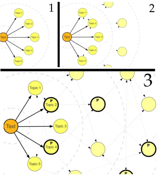
Wikipedia can be seen as a huge graph in which articles represent nodes and links among them represent directed edges. Since the result of the topic indexing task described in the previous section is the subset of Wikipedia articles that are topics from the text, we can consider our target text document as a new node, in which topics are the edges that connect it to the existing graph. In Wikipedia, links are included to connect entries to other concepts that help readers understand the article, correlating it to a wider context. Considering this, Wikipedia’s graph represents a large semantic network, containing several important concepts defined and refined by the common sense of many users.
Our method is based on a breadth-first search on this graph, starting from the node that represents the document being geotagged. This kind of graph search begins at a specific node and visits all of its neighbors, then visits all neighbors from the already visited nodes, and keeps going on recursively until it visits the whole graph component. During the visit to a node, we check whether it corresponds to a known place from the predefined list and, if so, we consider it to be a candidate geotag.
Considering the moment in which a place is reached in the breadth-first search, we can take the current depth of search as the minimum distance from the start node to the place. We then use this information to establish a distance metric (Dp) that quantifies the impact of a certain placepwhen it is found in the search. If some of the places are already present in the topics of the text document, those have Dp = 1. If a place is found because it is adjacent (in the graph) to some of the original topics in text, it has aDp = 2.
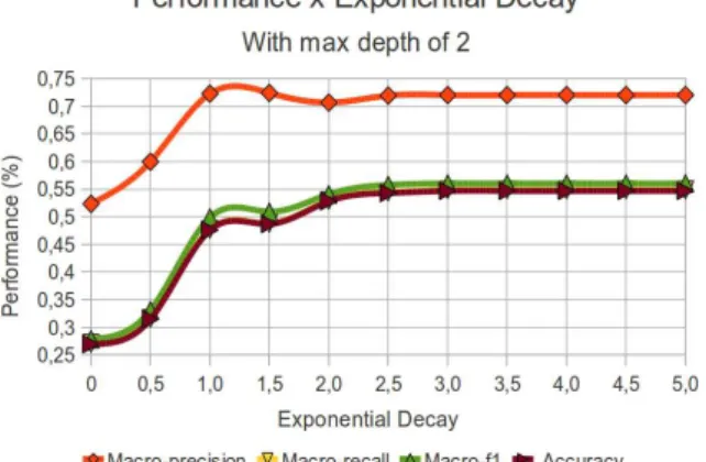
Concerning the search depth, we use a limit (maxdepth) in order to avoid the full search of the graph. This must be done because if we explore the entire graph compo-nent that is accessible from our start node, we will probably get much unnecessary and confusing information, distant from the original context. Notice that when we find a few places in the first depth levels, they probably contain edges to more general places (e.g. states have links to their corresponding countries). If we keep searching, those general places will also link to other specific nodes, siblings of the ones found first, and that could decrease the chance of finding relevant candidate places. In preliminary tests we observed that a maxdepth of more than 2 levels had covered a large portion of nodes from the almost 1 million nodes of the Portuguese Wikipedia graph. In the result section 4.3 we present more details on this issue.
3.3. Strategy 2: Identifying Geographic Context through Topic
Indexing with Wikipedia 29
Figure 3.6. Discovering places related to a wikified text in Wikipedia’s graph.
as the first connections to the Wikipedia graph. In the second moment (2), we start to work with links between those topics and from the topics to new Wikipedia entries, representing other nodes from the graph. In the third moment (3), after exploring the Wikipedia graph in deeper levels, we can look for those nodes that are about places to proceed with the geotagging process.
30
Chapter 3. Using Evidence from Wikipedia to Automatically Relate Texts to Places
nodes point to it.
The distance and adjacency count metrics for a place p can be combined to generate a final metric called Scorep, which decreases the Cp value dividing it by Dp
to the power of an exponential decay factor (See equation 3.8).
Scorep = Cp
(Dp)expdecay (3.8)
As a result, Cp represents the relevance of the place in the context of a document, but this the Scorep degrades as this place is considered to be farther away from the original topics in the semantic network. As a final result from the search step, we obtain a list of candidate places P, each of which accompanied by a measure of the relevance of the place to the context of the textual document we want to geotag.
3.3.4
Evaluating Certainty and Choosing Responses
Given the list P of candidate places, we must now generate a set of tags that define the geographic scope of the text document. First of all, if P is empty, it means that the topics identified in the text could not provide any information on the geographic entities related to the context. In this case the document is not geotagged.
If one or more places are listed in P, Scorep provides a filtering measure, i.e.,
Scorep allows to select the most relevant tags, and filter out less relevant responses. We propose some selection strategies, with varying selectiveness:
• Top k: sort tags downward by Scorep, then select the first k tags.
• Global Threshold: define a minimum valuev forScorep, and return all pinP
where Scorep ≥ v. Scorep must be normalized in order to define a general-use, percentage-based threshold.
• Relative to First Threshold: considering the candidate places list P sorted downward by Scorep, calculate the percentage of gain g relative to the first place
p1 to the next placespi usinggi =Scorep1/Scorepi. Define a minimum gain value
v and return all pi so that gi ≥ v. The idea is that the selected tags must be nearly as good as the first one in the ranking. Low g values allow less important tags to be included in the response, while values close to 1.0 make it return only those tags in whichScorep is close to the top one. At least the top scorer will be part of the response.
• Relative to First Threshold with Top-k: the same as the previous strategy,
3.3. Strategy 2: Identifying Geographic Context through Topic
Indexing with Wikipedia 31
Chapter 4
Experimental Evaluation
Now we present an experimental evaluation of both strategies proposed in the Chapter 3. The tests are all based on a collection of news we have built, in which every single news is associated to a Brazilian state as its geographic scope. We characterize this collection in section 4.1. Then, in section 4.2, the automatic classification strategy proposed in section 3.2 is evaluated. We demonstrate the feasibility of using Wikipedia to generate features for automatic text classification using machine learning. We use as baseline a classic automatic text classification task that does not use our Wikipedia features scheme, and then we check our strategy lacks and advantages. Finally, in section 4.3, we experiment with the topic indexing with Wikipedia strategy presented in section 3.3. Automatic evaluations are performed based on the precision of the method when trying to geotag news with the right state. We also perform a manual evaluation, with a small subset of the news collection, in order to better understand the circumstances that lead the process to some of the errors revealed by the experiments.
4.1
Building the Test Collection
For each of the 27 Brazilian states, we performed a manual search for relevant news websites about the locations. In those websites we usually find a section dedicated to local subjects, and we considered it to be a good source of texts with a geography scope limited to a single state level. We attempted to collect about 100 news articles for each state, and we read their titles before collecting them in order to be sure they were really about a local subject. Only the title and body text of the articles were stored, using an automatic collector based on XML Path Language (XPath) expressions. As a result we built a collection of almost 2700 text documents in Portuguese, all of them with a single Brazilian state as an expected label (see Table 4.1).
34 Chapter 4. Experimental Evaluation
The news sources was chosen based on the presence of a local section in the news website, and also by observing how easily the news could be collected by XPath expressions. The relevance and popularity of such sources was not the main aspect observed, since the goal was to collect texts strongly related a certain place, not matter where they were found.
For the automatic classifier strategy (Section 3.2), we used only a subset of the collection, containing only the following states: Minas Gerais, Rio de Janeiro, São Paulo, Acre, Amazonas, Bahia, Santa Catarina and Pernambuco.
For the topic indexing strategy (Section 3.3), we used the whole collection. The topic detection algorithm presented by Milne and Witten (2008) was adapted to the Portuguese version of Wikipedia using a XML dump of the digital encyclopedia released in March 2010. For caching purposes we performed the topic indexing process over all documents from the collection. The topics were stored in text files as a list of Wikipedia pages IDs. Both data sets, the raw news text and the cached news topics, are available at our laboratory’s website 1
for public usage.
4.2
Results for the Classifier Strategy
In order to check the validity of the automatic classification strategy (Section 3.2), we performed experiments on the single label classification of news documents according to a subset of the Brazilian states. Test data were extracted from local or state news sections of newspaper Web sites. We then performed an automatic classification using a bag-of-words approach with a TF-IDF weighting scheme to serve as a baseline. Finally, we applied the proposed method to the same documents and compared the classification results to the baseline.
After collecting and extracting news texts, each document had their stopwords removed and their remaining terms stemmed, so that the classification process would only work with keywords. We used the stopword list for Portuguese compiled by the Snowball project2
. Regarding stemming (a process that reduces words to their radical form, eliminating variations such as plurals, gender, and verb tenses), we used the Orengo algorithm for Portuguese (Orengo and Huyck, 2001), as implemented in the PTStemmer project3
. The same treatment was applied to the titles of entries from Wikipedia, in order to allow the matching of terms in the documents. We only considered news from 8 of the 27 Brazilian states, including three important ones
1
http://www.lbd.dcc.ufmg.br/collections
2
Snowball, http://snowball.tartarus.org/ - accessed on Dec 3 2009
3
4.2. Results for the Classifier Strategy 35
(Minas Gerais, Rio de Janeiro and São Paulo), and others which are representative of the other geopolitical regions of the country.
4.2.1
Baseline: Traditional Automatic Text Classification
The usual technique for text classification is based on comparing term distributions and occurrences in a document to the frequency of terms that are common to previously defined document classes. The semantics of each term is irrelevant for this technique, since the classifiers only compare terms as strings of characters. We used this approach to classify documents from the test collection in order to get a baseline result.
The popular bag-of-words model reduces documents to lists of terms, presented to the classifier as a set of TF-IDF (Term Frequency, Inverse Document Frequency) measurements (Salton and McGill, 1986). In this model, each document is considered to be a set of terms, and a union set of terms is built from all documents. The TF-IDF measurement is calculated from two components. The TF component represents the frequency of the term in a document, normalized by the number of terms present in the document (Equation 4.1). The IDF component measures the inverse frequency of the term in the collection, log-normalized by the number of terms in the union set (Equation 4.2). The final measurement is the product of the two components for each document (Equation 4.3). TF-IDF results are low for common terms, and high for rare terms.
tfi,j = Ptfi,j
knk,j
(4.1)
idfi =log |D|
|{d:ti ∈D}| (4.2)