Master Thesis
Enhancing Information Retrieval in Folksonomies Using Ontology
of Place Constructed from Gazetteer Information
Rania Sabrah
March 2009
Institute for Geoinformatics
University of Muenster
First Advisor: Prof. Dr. Werner Kuhn
University of Muenster, Germany
Second Advisor: Mohamed Bishr
University of Muenster, Germany
Table of contents
1. Introduction... 1
1.1. Background ... 1
1.2. Motivation... 2
1.3. Context of the Research problem... 2
1.4. Problem statement... 3
1.5. Research Hypothesis ... 3
1.5.1. Research objectives ... 3
1.5.2. Research questions... 3
1.6. Methodology ... 4
1.7. Expected Results ... 4
1.8. Conclusion ... 4
2. Related work... 5
2.1. Folksonomy... 5
2.2. GeoSpatial Information extracted from Folksonomy: ... 7
2.3. Folksonomy characteristics... 9
2.4. Gazetteer ... 10
2.4.1. Gazetteer components... 10
2.4.2. GeoNames ... 11
2.4.3. Semantics of spatial relationships in gazetteer ... 12
2.5. Ontology of place:... 12
2.6. Conclusion ... 13
3. Folksonomy, Problems and Approaches ... 15
3.1. Folksonomy Definition ... 15
3.2. Tagging Behavior... 16
3.3. Folksonomy aspects ... 17
3.3.1. Tagging Relationship... 18
3.3.2. Tag Frequencies... 19
3.4. Folksonomy Problems... 19
3.4.1. Synonyms and homonyms ... 20
3.4.2. Basic Level Variation ... 20
3.4.3. Lack of Hierarchy ... 20
3.4.4. Absence of controlled vocabulary: ... 20
3.5. Approaches ... 21
3.6. Conclusion ... 21
4. Ontology of Place ... 23
4.1. Ontology definition ... 23
4.2. Ontology of Place... 24
4.3. Ontology Design ... 24
4.4. Implementation Issues... 29
4.5. Conclusion ... 29
5. Formalizing Ontology of Place... 31
5.1. Selecting Country for case study ... 31
5.2. Tagging system (Flickr) ... 32
5.2.1. Search for photos ... 32
5.2.2. Retrieve tags of the photos ... 33
5.2.3. Edit Tags... 34
5.2.4. Check Tags ... 34
5.3. Querying Gazetteer (GeoNames)... 35
5.3.1. Study of Feature Types... 35
5.3.2. Gazetteer reports styles... 35
5.3.3. Query Gazetteer ... 36
5.3.4. Check report ... 37
5.4.1. Constructing the ontology... 37
5.4.2. Checking the ontology... 39
5.4.3. Edit ontology in protégé ... 39
5.5. Conclusion ... 40
6. Prototype of a Search Tool ... 41
6.1. Developing a search tool for ontology enhanced folksonomy ... 41
6.1.1. Search for a place... 41
6.1.2. Suggestions of related places... 43
6.2. Evaluation and Results... 45
6.2.1. Evaluation method ... 45
6.2.2. Ontology of place testing for precision and recall ... 45
6.2.3. Test Results... 46
6.2.4. Results discussion... 47
6.3. Conclusion ... 48
7. Conclusions and Future Work ... 49
7.1. Achieved results against research outline ... 49
7.1.1. Can the dynamic knowledge provided by folksonomies be used as a resource for acquiring bottom-up knowledge?... 49
7.1.2. What is the ontology of place? And how to formalize such an ontology? ... 50
7.1.3. How can we enhance information retrieval in folksonomies by establishing explicit spatial “Part-Of” relationships? ... 50
7.2. Future work ... 50
References ... 52
List of Figures
Figure 1.1: Image retrieval ... 2
Figure 2.1: London city boundary………. ... 8
Figure 2.2: Boundaries of top 100 places in London center ………... 8
Figure 2.3: Search in Google maps ... 9
Figure 2.4: GeoNames Feature classes... 11
Figure 3.1: Users in web 1.0 and web 2.0 ... 15
Figure 3.2: Photo from Flickr... 16
Figure 3.3: Flickr Interface... 17
Figure 3.4: Schematic depiction of the collaborative tagging process ... 18
Figure 4.1: Gruber Ontology Definition... 23
Figure 4.2: Ontology of Place conceptual design... 25
Figure 4.3: Taxonomy of gazetteer feature types ... 26
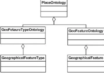
Figure 4.4: Geographic Feature Type Ontology conceptual design ... 28
Figure 5.1: Approach workflow ... 31
Figure 5.2: Geographic Feature Type ontology in protégé ... 38
Figure 5.3: Ontology of Place in protégé ... 40
Figure 6.1: Search tool interface ... 42
Figure 6.2: Result list ... 42
Figure 6.3: Result of searching for photos ... 43
Figure 6.4: Suggested places that are related to Sacramento, capital of California state…………. ... 43
Figure 6.5: Suggested places that are related to Sacramento, McLean county, Kentucky state...44
Figure 6.6: Result set of search using, a: place name only, b: using place name and parent name...….45
List of Tables
Table 4-1: Feature types used to construct the Geographic Feature Type Ontology ... 26
Table 6-1: suggested places types for each feature type ... 44
Table 6.2: search result from Flickr ... 47
List of Code Snippets
Code snippet 5.1: Request to Search for photos... 32Code snippet 5.2: Request to get tags list for a photo ... 33
Code snippet 5.3: gazetteer search request to retrieve geographic information of place names ... 36
Code snippet 5.4: constructing the geographic feature ontology ... 38
List of Results
Result 5.1: one photo record returned from the search... 33Result 5.2: Tags list of one of the photos ... 33
Result 5.3: Sample from resulting XML file with unique tags ... 34
Result 5.4: search result retrieved from gazetteer for a place name ... 37
Abstract
Folksonomy (from folk and taxonomy) is an approach to user metadata creation where users describe
information objects with a free-form list of keywords (‘tags’). Folksonomy has have proved to be a
useful information retrieval tool that support the emergence of “collective intelligence” or
“bottom-up” light weight semantics. Since there are no guiding rules or restrictions on the users, folksonomy
has some drawbacks and problems as lack of hierarchy, synonym control, and semantic precision.
This research aims at enhancing information retrieval in folksonomy, particularly that of location
information, by establishing explicit relationships between place name tags. To accomplish this, an
automated approach is developed. The approach starts by retrieving tags from Flickr. The tags are
then filtered to identify those that represent place names. Next, the gazetteer service that is a
knowledge organization system for spatial information is used to query for the place names. The
result of the search from the gazetteer and the feature types are used to construct an ontology of place.
The ontology of place is formalized from place name concepts, where each place has a “Part-Of”
relationship with its direct parent. The ontology is then formalized in OWL (Web Ontology
Language). A search tool prototype is developed that extracts a place name and its parent name from
Acknowledgment
First and foremost, I would like to express my thankfulness and humility to Allah most high for
giving me the power and will to finalize this research.
I would like to express my gratitude to my three advisors. My deepest thanks to my first advisor
Prof. Dr. Werner Kuhn for his continuous support and valuable comments. Also my appreciation for
the highly scientific classes I attended with him. Special thanks are due to my second advisor
Mohamed Bishr for his close follow up with all the work done in this research, his bright constructive
ideas to improve it, and for teaching me how to make a scientific research in 2005 and everything else
he taught to me since then. I would also like to express my thankfulness to my external advisor Prof.
Dr. Fernando Bação for his remarkable suggestions and comments to enhance the work.
Special thanks to Dr. Krzysztof Janowicz for his scientific discussions and recommendations
that were always fruitful. Also special thanks to Sven Schade for his interest and valuable hints.
I am deeply indebted to all my professours and lecturers in Universitat Jaume I (UJI), Castellón,
Spain and in Westfälische Wilhelms-Universität Münster (WWU), Institute for Geoinformatics (ifgi),
Germany. Through each and every one of them I have expanded my knowledge and learned a lot.
I would also like to salute all my friends that I met in the geospatial technologies program. I
would like to thank them for introducing their experiences and cultures, also for being a second
family, brothers and sisters.
Finally yet importantly, I would like to thank my family for their continuous support,
encouragement, and for putting up with me in all times. Their prayers were the main source of
inspiration, motivation and encouragement to continue my study.
Rania Sabrah
List of Acronyms
ADL Alexandria
Digital
Library
AI Artificial
Intelligence
API Application
Programming
Interface
CA Canada
CASE
Computer-aided Software Engineering
DB Database
DL Description
Logic
FTT
Feature Type Thesaurus
GNIS Geological
Survey
Geographic Names Information System
NGA
The National Geospatial-Intelligence Agency
NLP
Natural Language Processing
OWL
Web Ontology Language
RDF
Resource Description Framework
UML
Unified Modeling Language
USA, US
United States of America
1. Introduction
The goal of this research is to build a search mechanism that enhances information retrieval in
folksonomy. In the following we describe the research background, state the motivation, and
explain the methodology that will be used.
1.1. Background
The term “Web 2.0” became notable and widespread after the first “Web 2.0 conference” in 2004.
Among the notions that emerged with web 2.0 are folksonomies. Folksonomy (from folk and
taxonomy) or collaborative tagging is an approach to user metadata creation where users describe information objects with a free-form list of keywords (‘tags’) (Speller, 2007). Tags serve as way of
organizing content for future use, including search and navigation. Tags are called "social tags"
when they are available to others, to view or search, after being created by their owner. Social tagging systems such as "Flickr"1, for photo sharing, is becoming more and more popular with a
huge number of participants sharing and tagging a large number of photos. In June 2005 when
Yahoo acquired Flickr (since then the users numbers haven’t been announced) it was announced that Flickr has 775,000 registered users and 19,5 million photos and a 30 percent monthly growth
rate. More recent statistics shows that there are almost 3 billion photos. In fact, more than 160,000
images were tagged in one morning in October 2008, and more than 2.8 million images Geotagged in that month. Yet, folksonomy is not a formal taxonomy as there is no hierarchy, and no directly
specified parent-child or sibling relationships between tags (Mathes, 2004), in other words
folksonomies are devoid of formal semantics.
On the other hand, few years earlier Tim Berners-Lee articulated the semantic web vision
(Berners-Lee, Hendler, & Lassila, 2001). "Ontology" is one of the main themes of the semantic
web, and was defined by (Guarino & Giaretta, 1995) as “A logical theory which gives an explicit, partial account of a conceptualization” where conceptualization is an intentional semantic structure
which encodes the implicit rules constraining the structure of a piece of reality. An important
observation regarding the Semantic Web is that it still suffers from knowledge sparseness (i.e., it presents good coverage for certain topics, but very low coverage for others) (Angeletou, Sabou,
Specia, & Motta, 2007). Nevertheless, we should not think that Web 2.0 and the Semantic Web,
tags and rdf, folksonomies and ontologies are competing for the same space. The important question with respect to semantic web technology and Web 2.0 is not how to manage a trade-off,
but rather, how to use them together for the best advantage (Szomszor et al., 2007). It has been
proposed by researchers in different fields that integrating these technologies will preserve the simplicity and easiness of folksonomies and at the same time enhances its structure and value by
accomplishing explicit relations between tags. A considerable number of investigations are motivated by the vision of “bridging the gap” between the Semantic Web and Web 2.0 by means of
ontology-learning based on folksonomy annotations (Cattuto, Benz, Hotho, & Stumme, 2008)
Giving names to places is the simplest form of georeferencing, and was most likely the one first developed by early hunter-gatherer societies (Longley, Goodchild, Maguire, & Rhind, 2005).
Most people use place names to refer to geographical locations, and will usually be entirely
1
ignorant of the corresponding coordinates. The 150 most popular tags on Flickr are tabulated and
listed on the site. As of October 15, 2008, this list included Over 25% (39 out of 150) proper place
names like cities or countries, and this percentage was checked in other dates and found to be almost always the same. Users who search for photos also use place names and often they extend
their search to other related places, but it is done iteratively as there are no explicit relations
between places. Gazetteers solve this problem as they are knowledge organization systems for spatial information. They deliver feature types and geographic footprints for searched place names
(Hill, 2006), as well as spatial relations indicating that a place is “part of” another (e.g. Los Angeles is part of California and California is part of United States)2 which is an explicit
relationship between place names that can be used in related search.
1.2. Motivation
Searching large databases of images is a well-known problem commonly referred to as image retrieval (Aurnhammer, Hanappe, & Steels, 2006). In a search for tagged photos, a user needs to
find photos of places that are related to the same place name she/he typed e.g. the user will search
to find photos taken in “Muenster” (tagged with “Muenster”) and would also like to see photos taken in places around the city or in Germany in general. Current folksonomies do not provide
relations between place names, making it difficult to efficiently search by place.
1.3. Context of the Research problem
Websites using folksonomies allow users to search their database for resources tagged by the searched keyword. Figure 1.1 shows the sequence of steps to add and retrieve photos from the
database:
1- Upload photo 1 2- Assign permissions
3- Add tag
Figure 1.1: Image retrieval
1- Users in Flicker take the following steps to add their photos a. Upload photos through the web site
b. Assign permissions to be public (visible to anyone), or private (visible to family only,
friends only, both of them, or only for the user).
c. Add tags with any keyword, description, or change any of the properties of the photo.
2- The uploaded photo and its attributes are added to the database
2
http://www.alexandria.ucsb.edu/
Database Server Web Server
Search for keyword
Return matching photos
Query DB
Retrieve photo
6 3
5 4
3- Later, other users can search for photos by submitting a search keyword
4- The database is queried to find photos tagged with this keyword
5- Photos that match the search is retrieved from the database
6- The resulting matching photos are returned to the user depending on the permissions assigned to the photos, photos assigned as private are not returned to public users.
This scenario raises two challenges
1- Finding the appropriate result for the searched keyword. If it is a place name all photos tagged
on this place should be returned to the user.
2- Suggesting to the user other related tags, of related places (related in the sense of location not
as words). This permits users to navigate through a hierarchy of places when conducting place
based search.
1.4. Problem statement
Folksonomy lacks hierarchy, synonym control, and semantic precision (Bishr & Kuhn, 2007).
Searching for objects tagged with a word in folksonomies, is based on keyword search. Therefore,
a related search (suggesting related tags) can not be given to the user. Currently there are no available mechanisms to manage, organize, and relate the place name tags. The available
clustering of tags is done based on statistical methods and doesn't take location into consideration.
If a user needs to extract all objects for related places, she/he has to repeat the search as many times as the number of places required to cover all the possible tags that could have been used by
taggers. Another problem may face the user if she/he doesn’t know the exact name of all the
places, only some of them, or if these objects are tagged by a local name or synonym (e.g. using Firenze for Florence).
1.5. Research Hypothesis
Lightweight ontologies of place extracted from folksonomies enhance information discovery, by
improving their structure, and add semantic richness by defining explicit relationships between place names.
1.5.1. Research objectives
1- Extract place name tags from other tags.
2- Improve the structure of the folksonomy by establishing explicit “Part-Of” relations between place name tags and formalizing them in ontology of place.
3- Use the ontology of place to enhance information discovery and retrieval in folksonomies.
1.5.2. Research questions
1- Can the dynamic knowledge provided by folksonomies be used as a resource for acquiring
bottom-up knowledge?
2- What is the ontology of place? And how to formalize such an ontology?
3- How can we enhance information retrieval in folksonomies by establishing explicit spatial
1.6. Methodology
Our methodology is to automate an approach for acquiring tags from folksonomy, disambiguate
place name tags using a gazetteer service, and finally formalize an ontology of place using these place names and their spatial relationships retrieved from the gazetteer service. The ontology of
place will then be used to enhance folksonomy and improve information retrieval. To achieve this
we follow these steps:
1. Tags from a folksonomy website (Flickr) will be collected using the API (Application
Programming Interface) of the website, and then stored in an XML (Extensible Markup Language) file
2. Place names have to be mined from this file. A gazetteer API will be used to search for place
name tags; the names which correspond to a place will return spatial information.
3. Spatial relationships have to be discovered between related places. From the returned
locations, relations between places “Part-Of” can be identified.
4. The places and their relations have to be organized in a concept-relationship manner. This is accomplished by formalizing the place concepts and their spatial relationships in a lightweight
ontology.
5. The ontology will be tested and evaluated by implementing a search engine for finding photos tagged with place names.
1.7. Expected Results
This mechanism is expected to enhance information retrieval in folksonomies as it will allow for
semantically interpreting place names. Also using ontology of place will increase precision and recall, i.e. the search results will be improved. Besides, the ontology will allow for suggesting
hierarchy of related places to the user that she/he can navigate through them.
1.8. Conclusion
Folksonomy or social tagging is one of the technologies offered by web 2.0 with a potential to enhance information indexing and retrieval. Folksonomy lacks semantic precision, hierarchy, and
explicit relations between tags, which hinder its use. Formalizing ontology from tags and defining
explicit relations between them will add semantic richness, and improve the search results.
Place name tags implicit relations can be made explicit by the aid of gazetteer. Querying a
gazetteer with a place name returns its location, feature type, and relationships between places. An
ontology of place can then be formalized from the place name tags and their spatial relations acquired from the gazetteer. This procedure will preserve the simplicity of tagging systems and at
the same time add the missing semantic precision and hierarchy.
This research will extract lightweight ontology of place from folksonomy, by consulting a gazetteer service. The lightweight ontology is feedback to the folksonomy search environment, to
2. Related work
In this chapter we review the research done in the areas our research is concerned with. This
includes folksonomy, gazetteer, and ontology of place. More importantly, we focus on the work done to integrate these technologies. Many researchers have studied integrating folksonomy with
ontology and gazetteer with ontology, but to the best of our knowledge no research used data from
folksonomy with gazetteer service.
2.1. Folksonomy
This research is motivated by the vision introduced in (Bishr & Kuhn, 2007) explaining the
changing role of users from information consumers to both consumers and producers. Folksonomy
defined to be community based metadata, and a means of establishing semantics. The authors pointed to other work done in this field, such as (Mika, 2005) and (Gruber, 2005), that combines
folksonomies with ontologies. They stated that the resulting lightweight ontologies (from
folksonomy) can be used in a variety of applications, including enhancing the structure and value of a folksonomy, by allowing users to search for more abstract or specialized concepts within it.
In (Mika, 2005) a tripartite Actor-Concept-Instance model of ontologies was developed,
where actor is the user, concept is the tag and instance is object annotated (e.g. photo, website, ...). Networks of folksonomies were represented in this tripartite graph with hyperedges, two
lightweight ontologies are then extracted from the graph, one is based on overlapping communities
(ontology of actors and concepts) and the other is overlapping sets of instances (ontology of concepts and instances). The results of the two case studies show impressive results on the
emergence of semantics. The author concluded by noting the potential application of the results to
improve tagging systems e.g. by offering search and navigation based on broader/narrower terms. Also the ontologies emerging from folksonomies have a large potential for enriching established,
but slowly evolving linguistic ontologies such as Wordnet (Fellbaum & NetLibrary, 1998). This set
of defined triples of user-tag-resource was widely used in most of the research in folksonomy done after that, as it will be shown in the following review.
The second pointed work is (Gruber, 2005) where the model of (Mika, 2005) is extended to
include the source of the tag (the system where the tag originated) offering a Tagging (object, tag, tagger, source) construct in an ontology for tags dubbed TagOntology. The “source” was
introduced to allow the idea of integrating environments of social tagging i.e. enable analyzing and
reasoning over tag data across applications.
Based on these models, more research was done, all with the aim of integrating folksonomy
with semantic web, but with different approaches, one approach was to combine folksonomy with
lexical resources to formalize ontologies as in (Van Damme, Hepp, & Siorpaes, 2007), (Schmitz, 2006), (Specia & Motta, 2007), and (Specia, Angeletou, Sabou, & Motta, 2007), or formalize rdf
annotation as in (Maala, Delteil, & Azough, 2007), or even by developing interfaces for users to edit tags and use an existing ontology as in (Peters & Weller, 2008). The rest of this section
reviews these approaches.
dictionaries, Wordnet, Google and Wikipedia to disambiguate the tag sets obtained from different
systems. The tag sets are enriched by trying to establish mappings to elements in existing
ontologies. Also, the explicit relationships in existing ontologies were reused. As a final step a semi-automated approach was used, in which the aforementioned techniques are combined with
collective human intelligence i.e. community confirms the resulted ontology and contribute with
the missing information (e.g. missing relations between tags).
In (Schmitz, 2006) from Yahoo!3 Research team, he introduced ontology from Flickr4 tags by
using the statistical model for subsumption derived from the co-occurrence of tags, where a
condition is used to define one term subsuming another. In his approach he considered a tag x subsumes another tag y if the probability of x occurring given y (the probability of finding tag x, in
documents tagged with y) is above a certain threshold and the probability of y occurring given x is
below that same threshold, he expressed this relation using the following equations
P(x|y >= t) and P(y|x < t), Dx >= Dmin, Dy >= Dmin,
Ux >= Umin, Uy >= Umin
Where:
t is the co-occurrence threshold, Dx is the number of documents in which term x occurs, and must be greater than a minimum value Dmin, and Ux is the number of users that use x in at least one
image annotation, and must be greater than a minimum value Umin. He used this approach to develop what they called revised, probabilistic model. The subsumption model is applied on sets of
tags acquired from Flickr to build a graph of possible parent-child relationships.
In (Specia & Motta, 2007) a more sophisticated pre-processing of the tags is applied. They also identified groups of related tags, and investigated the nature of these relationships by
exploiting information available on the semantic web in order to give semantics both to the tags
themselves and to the relationships between tags. Their methodology consisted of three steps. First step is pre-processing, accomplished by setting some rules for text verification (e.g tags must start
with a letter), using similarity metric (implemented in the package SimMetrics5), and Filter out tags
occurring less than a certain number of times. Second step is clustering of tags statistically by organizing tags in co-occurrence matrix (nn symmetric matrix) and applying space statistics method. The last one is Concept and Relation Identification by mapping pairs of tags to concepts in
existing ontologies and then using wikipedia6 and google7 to establish relations. (Specia et al., 2007) continued the same work by focusing on the third step, they used each tag (not in pairs) to
extract all Semantic Web Terms (SWT) whose label or local name matches the tag, then identify
their relations.
(Maala et al., 2007) presented a new method to convert Flickr tags describing a picture into
RDF annotations. Tags are classified into six clusters (location, time, event, people, camera,
activity) using Wordnet. For the set of places in order to understand the meaning of the tags and correctly build an RDF annotation, the authors used a database built from crawling several websites
(like for instance Yahoo! Meteo) to obtain lists of cities, with the countries and continents in which
they are located, and also used an ontology of things where people can be (e.g. people can be in a
car, that can be on a road, that can be in a state, ...). Then all tags grouped in the location category
are ordered from the smallest to the largest, say (l1 ≤ l2 ≤ . .. ≤ ln). The generated triples are: (r, in, l1), (l1, in, l2). . . (ln−1, in, ln), where r is denoting the photo.
Activities to edit and organize tags have been described as "tag gardening” in (Peters &
Weller, 2008), they argued that the structured folksonomies are able to enhance recall but fail in enhancing the precision of search results due to the lack of linguistic processing of the tags which
has to be performed in advance of the semantic disambiguation of tags, and because automatic development or extraction of tag relations is the differentiation of the various associative relations
or the allocation of somehow related tags. They introduced manual activity, performed by the users
to manage folksonomies and gain better retrieval results. This approach propose using thesauri or lexical databases to detect synonyms and the user is asked to confirm that, and chose one of the
tags for indexing, then thesauri or ontologies may be used for query expansion and query
disambiguation. A tool is developed to allow the user to edit his tags from different platforms in the
same environment.
2.2. GeoSpatial Information extracted from Folksonomy:
Research in geoinformatics has also studied folksonomies, particularly how to integrate it with
current technologies offered by semantic web. Analyzing place semantics using folksonomy was
introduced in (Schlieder, 2007) and continued in (Schlieder & Matyas, 2008). Three initiatives have used geotags to generate boundaries (Grothe & Schaab, 2008), (Wilske, 2008), and (Cope,
2008a).
An approach for modeling the collaborative semantics of geographic folksonomies was introduced in (Schlieder, 2007), it is based on multi-object tagging (one tag is used to describe
more than one object) to analyze consequences for the semantics of place concepts. The author used the ternary tagging relation (object, tag, user) developed in (Gruber, 2005) but with a
collection as first argument: ageing({object1, … , objectN}, tag, user) a user-to-user similarity, in
place conceptualization, is then measured based on the objects (photos in this use case) selected by each user using Tanimoto measure for similarity, it resulted in communities of geospatial
information. With the same aim of looking at spatial choices to uncover spatial conceptualizations,
but more statistical approach (Schlieder & Matyas, 2008) automatically analyzed web-based collections of images of geographic objects located in cities to gain insight into the spatial choices
of the photographers. This approach was based on spatial clustering and has been implemented in a
software tool, the Heatmapper. They discussed the concept of (photographic) popularity of a place and introduced a measure of popularity for the points of view used by the photographers.
An approach towards an automated generation of Spatial footprints of vague places with
imprecise boundaries was introduced in (Grothe & Schaab, 2008), based on the statistical evaluation of a set of points acquired from geotagged photographs (has latitude/longitude
coordinates) from Flickr that are assumed to lie in the region. Two classes of statistical methods are
applied, kernel density estimation (KDE) and support vector machines (SVM), the two methods were used to estimate footprint of known regions to test their performance. Then the methods are
used to estimate footprints of Alps, Black Forest, and Rocky Mountains, the methods were
The results showed that the SVM approach outperformed the KDE in the majority of cases.
With the same aim of approximating the spatial footprint of neighborhoods but using different
method, (Wilske, 2008) used geotags to define vague boundary. First the geographic center of the region was determined using the spatial median of the set of points, and then the “egg yolk”
representation approach was used to approximate the boundary. A vague region is represented as a
pair of concentric regions with determinate boundaries: A core region (the “yolk”) that contains all locations that definitely belong to this region and a surrounding hull region (the “egg”) that
contains all locations whose membership to the region is indeterminate.
Flickr team of developers also published some articles on Flickr developers blog8 describing
their work in defining boundaries for continents, countries, cities, and neighborhoods. (Cope,
2008a) describes this approach, geotags are used with Alpha shape method; it is a geometric
concept which is mathematically well defined, using this methods most of the boundaries shown in this blog looked good compared to the exact boundaries. But it has to be taken into consideration
that boundaries has to be defined for each area separately, i.e. defining boundaries of all
neighborhoods inside a city will not define the city boundaries as shown in another blog called “GEOBLOGGERS” (Catt, 2008). Figure 2.1 shows the city of London defined using Alpha shape
for London geotags, Figure 2.2 shows city of London defined by top hundred places
(neighborhoods) in London center.
Figure 2.1: London city boundary Figure 2.2: Boundaries of top 100 places in London center
Figure 2.2 is the zoomed center of London. The overlapping boundaries shows that some photos are either tagged with inaccurate tags or located in wrong coordinates, and the gaps are
because these are only 100 places, and because some locations don’t have photos. This made Flickr
in the same blog (Cope, 2008a) invite users to organize what they called “PhotoWalk” around the edges of their neighborhood and add them to the map. These created boundaries are saved as shape
files and available to download using Flickr API.
Flickr also offer a method in their API, which is given a place ID as argument and returns
names and IDs of children places. The hierarchy defined for this parent child relation is
neighborhoods, localities (cities or towns), regions (states) and countries. This hierarchy is clustered by place type, as defined in (Cope, 2008b) they call this process inverse geocoding, the
article doesn’t explain more details about how this clustering is done.
8
On the other hand Google maps9 allows users to search for business in or near a location (e.g.
coffee in Seattle, or restaurants near Münster). In both cases as it is shown in Figure 2.3 the search
on the map displays result for business near the location, i.e. searching for “coffee in Seattle” or “coffee near Seattle” the results are displayed for “coffee near Seattle”. This method is used to
search for businesses only, it can’t be used to search for other geographic features as lakes, rivers,
...etc. And if it is used to search for “Lake near Münster” for example the returned result set are business places that has the word “Lake” as part of its name. Google allows the users to access this
information and imbed Google maps functionalities in websites through Google maps API, but the
documentation about how these functionalities are implemented is not available. The only source is the “Google Maps API discussion group” where it is explained that finding a business near a city is
done by searching a circle range around the centroid of the city. (Williams, 14 November 2007)
Figure 2.3: Search in Google maps
2.3. Folksonomy characteristics
A literature review was introduced in (Speller, 2007), he defines folksonomy as an approach to user
metadata creation where users describe information objects with a free-form list of keywords (‘tags’). This is done often to allow users to organize and retrieve the objects at a later date. The
paper lists some of the implementations of folksonomies such as “Del.icio.us” for bookmarking
web links, “Flickr” for photo-sharing, “CiteULike” for bookmarking scholarly writing and journal articles in particular, “Last.fm” for music and “YouTube” for video. The author argues that
folksonomy can make an important contribution to digital information organization, but that it may
need to be integrated with more traditional organization tools to overcome its current weaknesses. In other research (Cattuto et al., 2007) used statistical tools to gain insights into the underlying
tagging dynamics and introduced a stochastic model of user behavior embodying two main aspects
of collaborative tagging: (i) a frequency-bias mechanism related to the idea that users are exposed
9
to each other’s tagging activity; (ii) a notion of memory, or aging of resources, in the form of a
heavy-tailed access to the past state of the system. Remarkably, their simple modeling is able to
account quantitatively for the observed experimental features with a surprisingly high accuracy. This points in the direction of a universal behavior of users who, despite the complexity of their
own cognitive processes and the uncoordinated and selfish nature of their tagging activity, appear
to follow simple activity patterns. They considered this approach a starting point upon which more cognitively informed studies can be based, with the final goal of understanding and engineering the
semiotic dynamics of online social systems. Devising methods to measure the semantic relatedness between tags and characterizing it semantically is studied later in (Cattuto et al., 2008). In this
paper, they consider the three following measures for the relatedness of tags: the co-occurrence
count, the cosine similarity of co-occurrence distributions, and FolkRank. They map the tags of del.icio.us to synsets (sets of synonyms that represent one concept) of WordNet and use the
semantic relations of WordNet to infer corresponding semantic relations in the folksonomy. The
paper concluded that the three relatedness measures are best for studying three semantic
characteristics:
Cosine similarity to discover synonyms;
FolkRank and co-occurrence relatedness for algorithms to extract taxonomic relationships between tags (concept hierarchy);
FolkRank to discover multi-word lexemes.
2.4. Gazetteer
The core elements of a digital gazetteer are the place name, the type of place it labels, and a
geographic footprint representing its location and possibly its extent. Such gazetteer data is an
important component of indirect geographic referencing (or inverse geo-coding as called by Flickr) through place names. (Hill, 2000) describes the main components of gazetteers and explains the
development of Alexandria Digital Library (ADL) Gazetteer. (Janee, 2006) discusses the
limitations of the ADL gazetteer and the semantics of the spatial relationships defined between places. Developing an ontology as a modification of an existing feature type thesaurus is
introduced in (Janowicz & Keßler, 2008)
A gazetteer is defined by (Hill, 2000) as geospatial dictionaries of geographic names with the core components of
A name (could have variant names also)
A location (coordinates representing a point, line, or areal location)
A type (selected from a type scheme of categories for places/features).
2.4.1. Gazetteer components
Place Name:
A place name is used to reference a particular geographic object.
Place Location: A geographic footprint representing the location of a named place, is the other
component of a digital gazetteer. This footprint, in latitude and longitude coordinates, can be point,
bounding box, line, polygon, or grid representation.
as city or river. Different classifications of Place types may be used to serve different contexts of
use, e.g. topographic and administrative. Hierarchical classifications of Place types are often used
with sub-class and super-class relationships, e.g. a motorway is-a road. Place types may also be
spatially related, most commonly by containment relationships, modeled through “Part-Of”
hierarchies. However, other types of relationships may also be possible, e.g. intersection between
road objects.
Note the difference in the semantics of “Part-Of” relationships, where spatial “Part-Of”
denotes physical containment, whereas semantic “Part-Of” does not, e.g. a faculty (including a set of people) may be “Part-Of” a university but with no specific spatial relationship, while a
departmental building may have a “Part-Of” relationship of physical containment within a
university campus (G. Fu, Abdelmoty, & Jones, 2003).
2.4.2. GeoNames
In this section we review GeoNames10 which is an online gazetteer; as it is going to be used in our research to retrieve spatial information about place name tags. It is a geographic database with over
eight million geographic names.
b
a
Figure 2.4: (a) GeoNames Feature classes drop-down list, (b) extract from the feature codes classification
In the context of gazetteers, a feature is a real world entity. The feature type which is selected from a typing scheme or ontology is used for feature categorization. A named geographic place is
an abstract entity defined to refer to a physical region (extent) in space and categorized (typed)
according to commonly agreed upon characteristics (Janowicz & Keßler, 2008). As shown in (Figure 2-4), in GeoNames all features are categorized into one out of nine groups, called Feature
classes (it is not structured as a thesaurus; it is a simple list), and further subcategorized into one of
Agency (NGA) Feature Designation Codes. But the names of the classes were not adopted. The
most important sources of information in GeoNames are:
NGA : National Geospatial-Intelligence Agency's (NGA) and the U.S. Board on
Geographic Names (most names except US and CA)
GNIS : U.S. Geological Survey Geographic Names Information System (names in US).
www.geobase.ca (names in CA)
2.4.3. Semantics of spatial relationships in gazetteer
Semantics of spatial relationships is discussed in (Janee, 2006), the research shows that the ADL
protocol provides two ways of expressing containment constraints: searching spatially (e.g., find “Santa Barbara” spatially contained within California’s footprint) and searching relationally (find
“Santa Barbara” that has a Part-Of relationship to California). Conceptually, these two types of
queries were shown to be equivalent (or, at any rate, any difference between them is surely splitting semantic hairs).
Development of feature type ontology based on feature typing was proposed in (Janowicz &
Keßler, 2008) to improve both gazetteer interoperability and reasoning capability. Their approach is to take advantage of an existing feature typing scheme – the Alexandria Digital Library’s (ADL)
Feature Type Thesaurus (FTT) – to create a portion of such ontology. Difficulties in mapping from
feature type thesauri to ontologies are pointed out, a feature type ontology starting with the ADL FTT is created, and finally a description of how the proposed feature type ontology can be
integrated into the gazetteer communication paradigm is shown. The same approach will be
followed in this research to construct a geographic feature type ontology, that will be populated by place name tags to formalize ontology of place.
2.5. Ontology of place:
Ontology of place or geo-ontology is an ontology that holds geographic information, place name,
type, category and relations between places. Geo-ontology plays an important role in the development of “geospatial” semantic web, as it facilitates search for geographic information and
resources. In the following we review the challenges of constructing this ontology in (Fu, Jones, &
Abdelmoty, 2005), and (Abdelmoty, Smart, & Jones, 2007). And study constructed place ontologies in (Jones, Alani, & Tudhope, 2001) and (Henriksson, Kauppinen, & Hyvönen, 2008)
(Fu et al., 2005) argues that a geo-ontology plays a key role in the development of
spatially-aware search engines, with regards to providing support for query disambiguation, query expansion, relevance ranking and web resource annotation. In this research the authors focused on
the problem of integrating multiple datasets for constructing the ontology, and propose similarity
measures for the integration. The geo-ontology constructed in this research supports multiple names, maintains more than one geometric footprint for each place, maintains classification
categories of places, and encodes containment relationships between places. Four similarity
measures are proposed, two related to the thematic properties of a place (place name and place type) and two are related to the spatial properties of a place (footprint and geographical hierarchy
which is derived from containment relationships between places). The authors of this paper
10
published another research (Abdelmoty et al., 2007) that discussed the limitations of the OWL
ontology language for the representation of Place. In this paper, they discussed the particular
requirements of place geo-ontologies and the need for combining OWL and spatial reasoning rules to support their development and maintenance. Two frameworks for the development of Place
ontology management systems are proposed. The first approach assumes a centralized view of
ontology development, where the instance store (or ABox - assertion box which records observations of the world) is populated from available data sources. In the second approach, no (or
limited) instance store is assumed and the place information is derived from the integration of multiple data resources.
In a different approach (Jones et al., 2001) present an ontology of place that combines
limited coordinate data with qualitative spatial relationships between places. The aim is to match a specified place name (place is any geographic phenomena, i.e. city, lake, river, …etc) with place
names that refer to equivalent or nearby locations but not finding places that are conceptually
similar but possibly entirely separate in location. This similarity is determined based on a spatial
closeness measure which is the combination of two distance measures, regional hierarchy distance and Euclidean Distance between centroids. In order to measure the semantic similarity between
non-spatial concepts, they introduce a thematic distance. It is based on the principle of measuring the weighted distance between a pair of classification terms by the shortest number of links that
separate them in the semantic net of classification terms. The results showed that an automatic
ranking of places can be achieved by this approach.
In (Henriksson et al., 2008) they examine 1-the scope of geo-ontologies used for the purposes
of information retrieval on the Web, 2-the core geographical concepts and their mutual relations,
and 3-the concepts properties. They also discuss the Finnish geo-ontology and its development. They pointed out that geo-ontologies should contain classes that describe the spatial aspects of
places (e.g. location), regional geography (e.g. administrative regions), patterns based on human
interaction with nature (e.g. land use), and aspects related solely to the physical environment (e.g. landforms).
2.6. Conclusion
To sum up the review, this research is motivated by the vision of harvesting semantics offered by
folksonomy as proposed in (Bishr & Kuhn, 2007) and presented by several researchers that integrated folksonomy with semantic.
We reviewed the researches done in folksonomy, indicating the problems encountered while using
the system and the approaches taken to solve these problems and benefit from the emergent semantics that is offered by it. We focused in approaches taken to formalize semantic structures
from folksonomy, and also the approaches for acquiring spatial information from geotags.
Gazetteer service is studied, and the semantics of its spatial relationships is noted. Finally the different approaches to formalize ontology of places are reviewed, pointing out how they were used
to enhance information retrieval from the web.
The review of past researches will influence our research approach as we will follow the same approach as offered by (Janowicz & Keßler, 2008) to construct ontology of place from
administrative hierarchy levels defined in Feature Type Thesaurus, and linked by “Part-Of”
ontology of place will follow the outlines proposed in (Fu et al., 2005) and (Jones et al., 2001).
Place name tags acquired from Flickr will be disambiguated using a gazetteer service and will be
used to populate the constructed ontology of place. Furthermore, the ontology will be used for the development of spatially-aware search engine that can be used to disambiguate search for place
3. Folksonomy, Problems and Approaches
Tagging, folksonomy, distributed classification, ethnoclassification, are all labels for the same
technology. The concept of users creating and aggregating their own metadata is gaining ground on the internet (Speller, 2007). In this chapter folksonomy definition and aspects are going to be
discussed in more details. Also, the problems that arouse with tagging systems and hinder its use
are pointed out to be taken into consideration when developing our research approach. Finally the approaches that are taken by different researchers to minimize these problems and maximize the
benefit of folksonomy are explained.
3.1. Folksonomy Definition
Folksonomy is a method of indexing information over the web. Folksonomies are described in (Gruber, 2005) as an emergent phenomenon of the Social Web. They arise from data about how
people associate terms with content that they generate, share, or consume. He also pointed out that
such tagging systems attracted many users because they are easy to use, has no limit (tags can be as many or as few as a user wants), and there is no wrong answer.
The popularity of folksonomy was also due to the
change in role of the user in the emerging technologies of the social web, as articulated in
(Bishr & Kuhn, 2007). Users’ roles switched from
being data consumers to become data producers, or become “prosumers“ - producers and consumers
(Peters & Stock, 2007), prosumers collaborate not
only for the purpose of creating content, but to index these pieces of information as well. Besides, tags are
a form of metadata which allow searchers to easily
find images concerning a certain topic such as place name or subject matter (Maala et al., 2007).
As it shown in figure 3.1, this change in user role, led
the way to “collective intelligence”. In this context it is stated that “With content derived primarily by
community contribution, popular and influential
services like Flickr and Wikipedia represent the
emergence of “collective intelligence” as the new driving force behind the evolution of the
Internet.” (Weiss, 2005)
Figure: 3.1 Users in web 1.0 and web 2.0, Diagram source: http://web2.wsj2.com/
“Collective intelligence” arises from joint efforts of a group of authors or users in a so-called “collaborative services”. Such services can be summarized under the tag “Web 2.0”(O'Reilly,
2005). They offer possibilities for keeping or searching diaries (Weblogs, Technorati), for the
construction of encyclopedias (Wikipedia) and the management of bookmarks (Del.icio.us), photos (Flickr) or videos (YouTube). The collaboration does not stop with providing content but
Flickr is a digital image storage and management website. It is a place to organize photos into
albums, tag them with descriptive keywords, and view other users images. For example Figure 3.2
shows a photo in Flickr and its tags. Searching in Flickr for any of these tags (e.g. Las Vegas) will result in a set of photos that have “Las Vegas” as one of their tags, including the photo in figure
3.2. Flickr allows navigation by tag or user, as well as by group. Groups are places for users who
share similar interests to post their images such as “Las Vegas Vacations” and “Movies” groups (Kroski, 2006).
However, groups are more flexible than the traditional folder-based method of organizing files, as one photo can
belong to many groups, or one group, or none at all (the
concept is directly analogous to the better known “labels” in (Google’s Gmail). Flickr’s “Groups” then represent a
form of categorical metadata rather than a physical
hierarchy (Maala et al., 2007).
Figure 3.2: Photo from Flickr, tagged by (Vegas, Las Vegas, Nevada, america, uprightkangaroo, New York, statue, liberty) 3.2. Tagging Behavior
Studying the tagging behavior, (Maala et al., 2007) defined the following users tagging habits:
Very few tags: some photos contain no tag at all or very few tags (one or two).
Sentence tagging: users can use quotes to enter a full sentence as a tag, such as “You can not miss it” (in case no quotes are used, space is understood by Flickr as a separator
between tags). Figure 3.3 shows Flickr interface.
Vertical sentence tagging: it is the same case as the previous one, but users forget to (or intentionally did not) put the sentence between quotes. Thus the sentence can be read
vertically, because Flickr has understood each space-separated word to be a different tag.
Too many tags: contrary to the previous case, the information attached to the photo is very rich and describes many different aspects (content, location, etc.). In Flickr users can add
up to seventy five (75) tags for each photo.
Nonsense tags: these tags correspond to something not understandable for a human being not knowing the annotator universe of thinking such as “cs-tkl”
Space free tagging: the users write a sentence by concatenating words in order to put the whole sentence on the same line; for example a user has written the tag “Ilovenature”.
These users may not be aware of the possibility of using quotes.
Collective tagging: due to the interface Flickr provides, it is possible to tag several photos concurrently. Therefore it sometimes happens that a photo is described with a tag that does
Fig: 3.3 Flickr interface, a: tools to upload and organize user photos. (b): adding tags to photo
a
b
Although tags are user-defined and freeform, Flickr tags tend to naturally fall into five categories as defined by (Maala et al., 2007) and (Winget, 2006):
Place: the location can be described at varying levels of granularity. At the largest level of granularity, the continent, the country, the region, the city, a mountain range are found frequently. At a smaller level of granularity, description of the building or the immediate
natural site the photo was taken can be found: a building, a university, a house, a beach.
Finally at the smallest level of granularity, there can be a description of a room or a piece of furniture: bed, chair , etc.
Time: the time can also be described at different levels of granularity. The year, the season and the month are the most frequently found. The exact day is much less frequent. Some
times of the day are (sunrise, sunset, etc.).
Event: the holydays (Christmas), the birthdays, the weddings . . .
Name: people names (Emma, Jean ) or nicknames.
Camera: many tags indicate the make or the model of the camera (Nokia, Canon), the colors (black & white), artistic judgments on the photo.
3.3. Folksonomy aspects
The idea of folksonomy is to allow users to add keywords to a system to describe an object or a
resource. These objects differ from one application to the other depending on the goal of the site.
Despite these differences in applications’ goals, objects to be tagged, users of each application and the tags they use to describe the objects, folksonomy possesses some general aspects that will be
3.3.1. Tagging Relationship
The uncoordinated tagging activity of the users creates a dynamic correspondent relationship
between a resource and a set of tags, i.e. it creates an emergent categorization of the resources.
This means that the tagging process develops social features and complex interactions(Cattuto et al., 2007). This relationship is shown by figure 3.4, users add tags to a resource in the system, and
these tags define categorization of the resource.
Fig: 3.4 Schematic depiction of the collaborative tagging process, Diagram source: (Cattuto, Loreto, & Pietronero, 2007)
Figure 3.4 represents a tagging system, one resource is tagged by different users (user 1, user 2, etc.) each of the users’ added one or more tags, e.g. (User 1) tagged the resource with (tag “A”),
and (tag “B”), (user 2) tagged it with (tag “B”) and so on. Such relation was formalized by
(Gruber, 2005) as
Tagging (resource, tag “A”, User 1)
Tagging (resource, tag “B”, User 1)
Tagging (resource, tag “B”, User 2)
Generally it is expressed as: Tagging (object, tag, tagger). This relation is valid for one
application, in case of exchanging this data between more than one application the relation is
expressed as a four-place relation, with source (application) as part: Tagging (Object, tag, tagger, source)
This allows us to say something about a collection of tag data, independent of the specific
applications they come from. This triple of (object, tag, tagger) is called “Post” by (Cattuto et al., 2007) who argued that usually a post also contains a temporal marker indicating the (physical)
time of the tagging event, so that temporal ordering can be preserved in storing and retrieving
posts. Adding the time to the relation
Tagging (Object, tag, tagger, source, time)
Most of the objects tagged are associated with a location. For example in photo-sharing
the objects will allow for clustering them according to their location. Hence we get a six-place
relation of the form
Tagging (Object, tag, tagger, source, time, location)
This relation states that, the tagging relationship between a tag and an object creates
categorization of objects in the system. The relationship is identified uniquely in an application by considering the tagger (user who added the tag). In order to be able to use data from different
applications, the source is taken into consideration. The forth component in this relation is the timestamp indicating the time the relation was created. Finally the location associated with the
relationship adds the spatial dimension to the relationship where this object is located. Our
research falls in the context of studying this spatial dimension in tagging systems, which was not widely addressed before by other researches.
3.3.2. Tag Frequencies
In his research (Schlieder, 2007) proved that upon examining the tags by sorting them in order of
decreasing frequency of use, the tag frequency followed a power law. Also on their experiment
(Cattuto et al., 2007) showed that on plotting the number of distinct tags as a function of the total number of inserted tags, a clean power-law behavior without ever reaching a steady state plateau
can be observed throughout the full history of the resource.
In striking contrast to this, in the same experiment (Cattuto et al., 2007) showed that the relative proportion of tags associated with a given resource quickly approaches a quasi-stationary
condition. Once the number of posts associated with a resource is sufficiently large, single tagging
events have a negligible effect on the global distribution of tags, so that the existing distribution is reinforced, generally becoming more and more stable. This robustness is a very important property
of collaborative tagging. On the one hand, the fact that tag fractions stabilize quickly allows the
emergence of a clearly defined categorization of the resources in terms of tags, with a few top-ranked tags defining a semantic “fingerprint” of the resource they refer to. On the other hand, the
long-term stability of tag proportions makes the emergent categorization robust against noise.
Both aspects contribute greatly to the actual usability of collaborative tagging systems.
These observations show that there is an emergent semantics through categorization.
Capturing this semantics and formalizing it, in ontology for example, will significantly enhance
the system performance.
3.4. Folksonomy Problems
“Folksonomy” name was first coined by Thomas Vander Wal in a discussion on an information
architecture mailing list (Smith, 2004). It is a combination of “folk” and “taxonomy”. However, it
is argued that folksonomy is a misleading term as the systems in question bear very little relation to taxonomies or ontologies as clarified by (Merholz, 2004a) and explained by Vander Wal later in
(Vander Wal, 2005). Folksonomy has some drawbacks as pointed out by many writers (Schlieder,
3.4.1. Synonyms and homonyms
There is no synonym (different words, same meaning) control in tagging systems. This leads to
tags that seemingly have similar intended meanings, like “CA” and “California” both are used to
refer to “California State” in USA, this means that in a search for “CA” objects that are tagged with “California” will not be in the result of the search and vice versa. Plural vs. singular is often a
problem, as seen in the popular tags on Flickr, both “flower” and “flowers” were listed (Mathes,
2004). Web 2.0 services such as Technorati, Flickr and YouTube are used almost all over the world (Peters & Stock, 2007). Many users in non-English-speaking countries tag documents using
their own language like “Germany“, “Deutschland”, “Alemania”. This leads to the problems of
trans-language synonymy (i.e., translation).
On the other hand, homonym (same word, different meaning) represents a different but related
problem to synonyms (Speller, 2007). The presence of homonyms in the system means that search
precision is reduced. One example is that a search for ‘Orange’ may give results about both fruit and “Orange county” which is a place in “California state”, one of which is bound to be irrelevant
to the searchers’ needs (Weinberger, 2005). Flickr tries to improve precision by automatically
generating ‘clusters’ of terms to disambiguate different meanings of the search term, which can work well: for example, look at the clusters formed around the ‘orange’ tag. Of course, this
increase in precision results in a loss of recall as some photos may be tagged ‘orange’ only and as
such will not be found but, as (Kroski, 2006) asserts, this is a necessary trade-off.
This problem limits the precision and recall of an information retrieval system as it decreases its
ability to retrieve information.
3.4.2. Basic Level Variation
A thorny semantic problem is the issue of ‘basic level variation’ described by (Kroski, 2006). This
relates to how much detail an individual will go into when tagging a resource. In (Golder & Huberman, 2006) they give the example of an average person naturally tagging a photo as ‘bird’
when a birdwatcher would have naturally tagged it ‘robin’. This difference means that the two
users may find each other's tags next-to-useless because they are at the wrong level of specificity for their needs. This problem naturally recalls the notions of information communities and domain
ontologies that are used to resolve such issues.
3.4.3. Lack of Hierarchy
Folksonomies are flat systems. There are no parent-child relationships, no categories and
subcategories. Hierarchy is a distinguishing trait of traditional taxonomies that are able to provide a deeper, more robust classification of entities. Such systems allow users a finer granularity in
searching for resources.
3.4.4. Absence of controlled vocabulary:
According to (Guy & Tonkin, 2006) most users don't give much thought to the way they tag resources, and bad or "sloppy" tags exists heavily in folksonomies. Also they observed that, there
exists misspellings, incorrect encodings, and compound words, testing against multilingual
misspelt, from a language not available via the software used, encoded in a manner that was not
understood by the dictionary software, or compound words consisting of more than two words or a
mixture of languages.
Folksonomies are discovery systems, these mentioned problems decrease their ability to
discover and retrieve information. As mentioned in chapter 1 our research objective is to enhance
folksonomy by improving its information retrieval, this can be achieved by solving these problems or decrease its effect.
The result of these problems is an uncontrolled and chaotic set of tagging terms that do not
support searching as effectively as more controlled vocabularies (Guy & Tonkin, 2006). Despite
this fact, (Merholz, 2004b) argues that these problems should be addressed, as there are
encouraging potential benefits. He compares folksonomy to foot-worn paths or “desire lines” that
appear in a landscape over time, these are trails that demonstrate how a landscape’s users choose
to move, which is often not on the paved paths. A smart landscape designer will let wanderers
create paths through use, and then pave the emerging walkways, ensuring optimal utility. In the
context of folksonomy, this indicates that for optimal systems, rules shouldn’t be imposed on
users. Else users should be free to add any tag to index resources, then these tags have to be
formalized in a semantic structure as ontology, and fed back to the system to enhance its
performance. This point of view is also supported by the observation from (Cattuto et al., 2007)
discussed in section 3.3.2
3.5. Approaches
There are different approaches aiming to solve these problems of folksonomy some of them were
discussed in the related work in section 2.1. One approach is to educate users to improve “tag
literacy” (Guy & Tonkin, 2006). For training of the users to do this, it might be useful to suggest
some tags. Tag-suggestions can operate on a syntactical level (e.g., a user attaches “graph” and the
system suggests “graphics”) or even on a relational level (e.g., a user attaches “graphics” and the
system suggests “image”, because both words do often co-occur in documents’ tag clouds). This
approach involves establishing user research concerning folksonomies and studying the “semiotic
dynamics” underlying collaborative tagging as in (Cattuto et al., 2007).
Another approach is to consider tags as elements of natural language and treats them by means
of automatic methods of natural language processing (NLP), this can be reached by using thesauri
or lexical databases to detect synonyms semantics, as the approach taken by (Peters & Weller,
2008) and (Van Damme et al., 2007). It can also involve merging ontologies, e.g. a geographic
classification system, with a folksonomy to allow using the tags in their hierarchical relations as
well (Gruber, 2005).
3.6. Conclusion
Folksonomy is easy to use, and has no rules, this is the reason there are increasing numbers of
relationship with six dimensions to be: Tagging (Object, tag, tagger, source, time, location) with
the focus of this research on the “location” dimension of tagging systems. Studying tags frequency
showed that on plotting the number of distinct tags as a function of the total number of inserted
tags, a clean power-law behavior without ever reaching a steady state was observed, and on the
other hand the relative proportion of tags associated with a given resource quickly approaches a
quasi-stationary condition, this implies that formalizing a semantic structure of these tags as
ontology, will highly affect the system performance. Nevertheless, folksonomy has many
problems that hinder their use and hide the arising “Collective intelligence”, as synonym and
homonym problems, basic level variation between tags, folksonomy lack of hierarchy structure,
and uncontrolled vocabulary of users. These problems limit the system ability for information
retrieval and decrease their precision and recall. Many approaches have been taken to solve these
problems and add semantic structure to these tagging systems without enforcing rules on the user.
The results of these efforts have proven that there is emerging semantics in folksonomy. Our
approach in this research is another attempt to overcome folksonomy drawbacks and add semantic
structure to it. The approach is discussed in more details in chapter five, and its evaluation and
4. Ontology of Place
The most common way when searching for a location is to use place names. In order to assist in
recognizing place names, it is proposed to employ an ontology that encodes geographical terminology and the semantic relationships between geographic terms. The idea is that the ontology
of place will enable the search engine in folksonomy to detect that the query refers to a geographic
location and to perform a search which will result in the retrieval of photos that refer to the specified location (Jones et al., 2001)
4.1. Ontology definition
“An ontology is an explicit specification of a conceptualization” as defined by (Gruber, 1993) . A
‘conceptualization’ refers to an abstract model of some phenomenon in the world by identifying the relevant concepts of that phenomenon. ‘Explicit’ means that the type of concepts used and the
constraints on their use are explicitly defined, figure 4.1 plots this definition. Basically, the role of
ontologies in the knowledge engineering process is to facilitate the construction of a domain model. An ontology provides a vocabulary of terms and relations with which a domain can be modeled.
Figure 4.1: Gruber Ontology Definition (Lacy, 2005)
(Guarino & Giaretta, 1995) studied the different definitions given to “Ontology” to clarify
what is meant by it. They came to a conclusion that ontology can be defined as “A logical theory
which gives an explicit, partial account of a conceptualization” where conceptualization is an intentional semantic structure which encodes the implicit rules constraining the structure of a piece