Review article
A survey on the geographic scope of textual documents
Bruno R. Monteiro
a,n, Clodoveu A. Davis Jr.
b, Fred Fonseca
caDepartamento de Computação e Sistemas, Universidade Federal de Ouro Preto, Brazil bDepartamento de Ciência da Computação, Universidade Federal de Minas Gerais, Brazil cCollege of Information Sciences and Technology, Penn State University, USA
a r t i c l e
i n f o
Article history:
Received 29 September 2015 Received in revised form 21 June 2016
Accepted 25 July 2016 Available online 28 July 2016
Keywords:
Geographic scope resolution problem Geoparsing
Reference resolution Grounding references Information retrieval
Geographic information retrieval
a b s t r a c t
Recognizing references to places in texts is needed in many applications, such as search engines, loca-tion-based social media and document classification. In this paper we present a survey of methods and techniques for the recognition and identification of places referenced in texts. We discuss concepts and terminology, and propose a classification of the solutions given in the literature. We introduce a definition of the Geographic Scope Resolution (GSR) problem, dividing it in three steps: geoparsing, reference resolution, and grounding references. Solutions to thefirst two steps are organized according to the method used, and solutions to the third step are organized according to the type of output pro-duced. We found that it is difficult to compare existing solutions directly to one another, because they often create their own benchmarking data, targeted to their own problem.
&2016 Elsevier Ltd. All rights reserved.
Contents
1. Introduction . . . 23
2. Main application areas . . . 24
2.1. Information retrieval tools and techniques . . . 24
2.2. Web data mining . . . 25
3. The geographic scope resolution problem . . . 25
3.1. GSR terminology . . . 25
3.2. GSR: a definition . . . 25
3.2.1. Task 1: geoparsing . . . 26
3.2.2. Task 2: reference resolution . . . 26
3.2.3. Task 3: grounding references . . . 26
4. Proposed solutions to the geographic scope resolution problem . . . 27
4.1. Global solutions . . . 27
4.2. Geoparsing solutions . . . 28
4.3. Reference resolution solutions . . . 29
4.4. Solutions for grounding references. . . 31
5. Conclusions and future work . . . 32
Acknowledgments . . . 32
References . . . 32
1. Introduction
The demand for geographic data in applications on the Web is increasing. One of the most important resources to support this increased interest is the ability to recognize references to places in Contents lists available atScienceDirect
journal homepage:www.elsevier.com/locate/cageo
Computers & Geosciences
http://dx.doi.org/10.1016/j.cageo.2016.07.017
0098-3004/&2016 Elsevier Ltd. All rights reserved.
n
Corresponding author.
E-mail addresses:[email protected](B.R. Monteiro),
Web documents. If documents can be correctly and efficiently linked to places mentioned directly or indirectly in them, it be-comes possible to improve and innovate in directions such as geographic indexing and querying,finding relationships based on spatial proximity or containment, and detecting localized trends for events and phenomena mentioned in social media.
A large share of the information available on the Web is geo-graphically specific (Delboni et al., 2007; Vaid et al., 2005; Va-sardani et al., 2013). References to geographic locations appear in the form of place names, postal addresses, postcodes, historical dates, demonyms, ethnicity, typical food and others. Many queries include place names and other geographic terms (Delboni et al., 2007;Sanderson and Kohler, 2005;Silva et al., 2006). Therefore, there is demand for mechanisms to search for documents both thematically (for instance, using a set of keywords) and geo-graphically, based on places mentioned or referenced by the text (Zong et al., 2005). Similar techniques and resources can also apply to streaming data, such as Twitter messages or RSS feeds, pro-viding the opportunity to index content in near-real-time, based on references to places.
However, whilefinding references to places in Web documents, ambiguity and uncertainty occur. Places can share a name with other places (Paris, besides being the capital of France, refers to more than sixty places around the world1). Places are named using common language words (Park, Hope and Independence are American cities) and proper names (Washington, Houston and San Francisco). Thefirst type of ambiguity occurs when a place name references multiple places, and it is calledGeo/Geo ambiguity, or referent ambiguity. The latter ambiguity is called Geo/Non-Geo ambiguity (referent class ambiguity), which occurs when both a location and a non-location share the same name (Amitay et al., 2004). Clough et al. (2004) suggest a third type of ambiguity, named reference ambiguity, which occurs when a place is asso-ciated to many names, like New York, NYC or The Big Apple. Ambiguity makes the resolution of references to places in-trinsically context-based. Although there are important work on place-based information integration and retrieval, areas such as disambiguation are still in its infancy (Vasardani et al., 2013).
An important resource to address disambiguation is the de-termination of thegeographic scopeof the document, i.e., the set of places referenced by and relevant to the contents of the document.
‘Every document has a geographical scope”(Andogah et al., 2012). Even keyword queries to search engines can have a geographic scope (Alexopoulos and Ruiz, 2012;Silva et al., 2006), since query words embed the user's intentions in the search.
References to places can be straightforward and unambiguous as geographic coordinates or not. Other sources of geographic lo-cation information can be structured (postal addresses) or un-structured (place descriptions in text). They can also be direct (place names) or indirect (references to cultural characteristics associated to places), explicit (news headers) or implicit (“9/11”). Humans are often able to recognize references to places based on such evidence, but this association does not come so easily to automated systems. Addressing this problem is one of the pressing tasks for Geographic Information Retrieval (GIR) research.
GIR extends Information Retrieval (Baeza-Yates and Ribeiro-Neto, 1999) with use of geographic locations and metadata (Jones and Purves, 2009), taking it beyond the use of keywords. GIR studies methods and techniques for the retrieval of information from unstructured or partially structured sources, including re-levance ranking, based on queries that specify both theme and geographic scope (Jones and Purves, 2008,2009). One of the most important research subjects currently in GIR involves recognizing
references to places in regular text, and also in other media, such as photos and videos (Luo et al., 2011), including implicit refer-ences. The recognition of references to places in media other than text documents is beyond the scope of this paper.
Many initiatives to tackle the GIR problem of recognizing re-ferences to places in text have arisen in the recent past, usually with varied or conflicting descriptions or terminologies, targeting various applications, or using a range of reference data. The main contributions of this survey are (1) a structured and comprehen-sive view on contributions to the problem of determining the geographic scope of documents, (2) a review of relevant defini-tions and concepts, (3) a discussion of the main techniques cur-rently used to address the Geographic Scope Resolution (GSR) problem, and (4) a proposal for a future research agenda in the area.
This paper is organized as follows. Section 2introduces the main application areas related to the determination of the geo-graphic scope of documents.Section 3discusses the terminologi-cal variations found in the literature and presents them in a structured way.Section 4focuses on the GSR problem, presenting a set of methods and a discussion of existing techniques from the literature. Finally,Section 5shows our conclusions and indicates future research directions for thefield.
2. Main application areas
In this section, we present a high level description of what can be gained if efficient methods for determining the geographic scope of documents are available. The main application areas are divided into two groups: (1) contributions to IR, in the form of tools and techniques that incorporate geographic variables, and (2) contributions to Web data mining.
2.1. Information retrieval tools and techniques
Most of the initial work related to the geographic scope of documents comes from information retrieval (IR), largely due to the interest in evolving Web search engines by including geo-graphic features (Amitay et al., 2004;Buyukkokten et al., 1999;
Ding et al., 2000;Gravano et al., 2003;McCurley, 2001;Silva et al., 2006; Vaid et al., 2005). Query expansion, filtering, ranking of results and other IR techniques were adapted to use geographic data as soon as the solutions to establish the geographic scope became more efficient and more scalable. We highlight four techniques here, associated to various stages of a search engine's pipeline: geographic indexing, query expansion, recognition and use of place names included in queries, and geographic ranking.
Geographic indexing: Places can be associated to documents using a spatial/geographic index to support IR operations. Fur-thermore, collections of documents that refer to a place can be put together. Geographic indexing can also help infinding ideal locations for documents in a distributed storage infrastructure, considering that users from some geographic region tend to concentrate their interest on documents of local scope ( Lieber-man et al., 2010;Vaid et al., 2005). Query expansion: Searches performed using a place name can beexpanded using names of topologically-related places (i.e., neighboring places), as well as places that belong to the same territorial subdivision hierarchy (i.e., a search for documents related to a state can include documents referring to any of its cities) (Andogah et al., 2012; Delboni et al., 2007; Machado et al., 2011;Moura and Davis, 2014).
Use of place names in queries: Traditional search engines based on keyword matching did not consider that a keyword mightrepresent a geographic entity, and therefore a geographic lo-cation (Cardoso, 2011;Delboni et al., 2007;Martins et al., 2007). More recently search engines have started to consider place names in queries leading to improved search results.
Geographic ranking: Search engine users, particularly mobile ones, increasingly expect the search system to know their cur-rent geographic position and consider it in the ranking of re-sults, by extrapolating on their geographic context (Alexopoulos and Ruiz, 2012; Alexopoulos et al., 2013). Metadata can be captured to establish the relevance of a document as to the perceived interest of the user. Semantics can be used to determine how close a result is to the user's expressed inten-tions based on the geographic nature of the term that is being sought and from the user's search history (Andogah et al., 2012).2.2. Web data mining
In the late 1990s,Buyukkokten et al. (1999)presented the idea of determining the geographic scope of Web resources and pro-posed improvements in search engines to rank the results con-sidering the geographic distance between the user's location and the places mentioned in the documents. They also suggested the use of geographic information to target product sales, expanding the uses of data mining applications. Two sets of techniques are prevalent in this area, geographic filtering and document classification.
Geographicfiltering: In streaming data sources, such as RSS feeds and social network messages, geographic data can provide cri-teria for prioritization andfiltering of messages and documents according to the user's location. This is particularly interesting for news, traffic, and weather applications (Lieberman and Sa-met, 2012;Ribeiro et al., 2012). Document classification: Documents can be classified and grouped by their geographic scope. This classification makes it possible to create spatially-aware services such as map-based news selection applications. Besides that, data mining algo-rithms and methods can use the geographic scope to classify or to cluster documents and Web pages related to a given place (Alencar et al., 2010;Alencar and Davis, 2011;Morimoto et al., 2003;Teitler et al., 2008;Silva et al., 2006).The applications listed in this section are not exhaustive, and many more can be envisaged, in conjunction with techniques from machine learning (Anastácio et al., 2009; Gravano et al., 2003), data mining (Backstrom et al., 2010;Lieberman and Samet, 2012), and natural language processing (Drymonas and Pfoser, 2010). Many end-user applications can also benefit from solutions to the geographic scope resolution problem, including, but not limited to, map-based browsing (Lim et al., 2002; McCurley, 2001; Teitler et al., 2008) and user location inference (Davis et al., 2011;Yang et al., 2011; Ribeiro et al., 2012). The next section presents the problem of determining the geographic scope of documents and basic concepts related to it.
3. The geographic scope resolution problem
In this section, we review a set of concepts and the terminology used the description of algorithms and techniques addressing the Geographic Scope Resolution (GSR) problem. Key and ground terms and their respective definitions are extracted from the re-levant literature and adjusted to the proposed definition of the GSR problem, presented in more detail inSection 3.2.
3.1. GSR terminology
Toponym: A place name, i.e., a name that can be used to refer to places on Earth. The names are not necessarily unique, therefore different places can share the same name. Places are also named after people, other places, and other entities (Jones and Purves, 2008;Habib et al., 2013).Leidner (2007),Leidner (2008)presents an extended discussion on place names, including a historical perspective.
Toponym recognition: The process of identifying place names in text, also known astoponym extraction(Habib et al., 2013;Jones and Purves, 2008).
Toponym resolution: The process of mapping a toponym to an unambiguous set of spatial coordinates corresponding to a geo-graphic location (Leidner, 2007, 2008). Also known as toponym disambiguation(Habib et al., 2013),location normalization(Li et al., 2002) or geographical entity resolution (Alexopoulos and Ruiz, 2012).
Geographic Scope of Documents or GS(D): The GS(D) is the set of places and/or regions associated to a document's content ( Ando-gah et al., 2012;Buyukkokten et al., 1999;Ding et al., 2000). The GS (D) considers the places mentioned in the document, but not ne-cessarily has to consider all of them. Besides that, in its most trivial form, the GS(D) can be expressed as a set of coordinates of the places mentioned in the document. However, the GS(D) might represent these places more broadly if necessary. For instance, if many states of a country are mentioned in a document, a more adequate GS(D) may indicate the country itself as the document's scope. Some other terms are equivalent: geographic document footprint(Fu et al., 2005;Silva et al., 2006),geographic path(Vargas et al., 2012b), andgeographic focus(Amitay et al., 2004;Chen et al., 2010;Zubizarreta et al., 2008).
Gazetteer: A repository of georeferenced place names, usually enhanced with further information, such as the type/class, geo-graphic coordinates (usually called a footprint), and some con-ceptual or territorial hierarchy (Hill, 2006;Leidner et al., 2003). In other words, gazetteers are dictionaries of toponyms (Hill, 2000,
2006). Gazetteers are instrumental as sources of valid place names in place name disambiguation, and in establishing the location of places identified by name (Souza et al., 2005).
The next section presents a definition of the geographic scope resolution problem, in which the variety of terminologies used in referenced works are considered and standardized.
3.2. GSR: a definition
The Geographic Scope Resolution (Alexopoulos and Ruiz, 2012;
Andogah et al., 2012;Alexopoulos et al., 2013) problem consists in discovering places related to the contents of a textual document, disambiguating them if necessary, and using the resulting set of unique places to build the overall geographic scope. GSR is known under other names in the literature, with essentially the same definition, except for terminological differences:Place Name As-signment Problem (Zong et al., 2005; Amitay et al., 2004) or GeoReferencing(Gouvêa et al., 2008;Zubizarreta et al., 2008).
The problem of determining the geographic scope of a docu-ment can be structured in a sequence of tasks, as follows (Fig. 1):
1. Geoparsing: find all the references to places contained in the document;
2.Reference resolution: disambiguate these references, so that each can be associated to a unique place;
Tasks (1) and (3) are mandatory. Task (2) is required in most cases, due to the existence of ambiguity (Amitay et al., 2004).
Geoparsing includes toponym recognition, but can also deal with indirect references to places in text. Likewise, reference re-solution uses toponym rere-solution, but includes disambiguation based on evidence that goes beyond toponyms found in the text. These definitions are meant to encompass the broad range of methods we describe in more detail in the next sections.
Fig. 1 presents the GSR problem schematically. The input is represented by a document or a set of documents, and the output is the geographic scope, which can be used by a system as part of a more complex task or directly presented to users. White rectangles indicate each of the three tasks. Solid arrows indicate the direct sequence of steps to solve the problem. Dashed arrows indicate that the results of a later step can contribute to the resolution of a previous task in further iterations. The effects of disambiguation on geoparsing have already been studied and called “ reinforce-ment effect”(Habib and van Keulen, 2011), indicating that tasks 1 (Geoparsing) and 2 (Reference resolution) can be highly dependent.
Andogah et al. (2012) paradoxically use a preliminary geo-graphic scope, estimated using a scoring system applied on can-didate toponyms, to support disambiguation, showing that the process can be cyclical.
The next sections provide a generic view on each task. Litera-ture contributions to the global problem and to each task are presented inSection 4.
3.2.1. Task 1: geoparsing
Geoparsing is thefirst required task in solving the GSR pro-blem. The objective is tofind all references to places present in a document, which can be direct (toponyms) or indirect (mentions to other entities that are readily associated to a place or a geo-graphic location).
Geoparsing can be carried out using external evidence on place names and indirect references to places. Candidate terms are searched in gazetteers or geographic databases, using string matching or special text elements such as capitalized words in sentences. Indirect references to places are called implicit geo-graphic evidence(Cardoso et al., 2008) orlocation indicators( Le-veling et al., 2006). They are urban addresses, references to related entities or landmarks, nicknames, or even sets of coordinates.
Machine learning algorithms and other strategies can also be used for geoparsing, which can be seen as a specialized version of Named Entity Recognition (NER) (Nadeau and Sekine, 2007). NER aims at identifying any kind of entities mentioned in natural lan-guage sentences, including places, people and objects. The most
common NER algorithms used in geoparsing (Lieberman and Sa-met, 2011) are the Support Vector Machine (SVM), the Hidden Markov Model (HMM), and the Conditional Random Field (CRF).
Some proprietary and open-source systems can be used tofind toponyms, geographic phrases and other names in text. Examples include C&C tagger,2 Apache's OpenNLP,3 OpenCalais,4 Yahoo!'s Placemaker,5
Sheffield's GATE,6 Ling-Pipe,7 and Stanford Uni-versity's open source tagger.8
3.2.2. Task 2: reference resolution
Reference resolution is the process of mapping a place name or reference in documents to an unambiguous identification of the place. This definition also applies to toponym resolution.
This step is mandatory whenever the source data contain am-biguities, which is a very common problem in place names. Ac-cording toHabib et al. (2013), around 46% of the toponyms found in GeoNames refer to more than one place. For instance, the to-ponym“Springfield”corresponds to more than one hundred and eighty different geographic places around the world, including places in the U.S., Australia, Jamaica, South Africa, and Canada.
Reference resolution usually relies on an external knowledge base, such as a gazetteer, a geographic database, or a combination of them. Toponyms and other references are used to search the knowledge base for candidate places. Additional evidence, from the document or from external sources, is then used to decide which place is more likely to correspond to the reference in the text. The quality of the results in this step is highly dependent on the quality and coverage of the external reference data.
3.2.3. Task 3: grounding references
Grounding references corresponds to the process of mapping each reference to a footprint, which may be a set of latitude and longitude coordinates, or a set of polygons, representing geo-graphic boundaries. When multiple references to places are found in the document, this step has to deal with the granularity of the geographic scope itself. This means that some decisions should be taken considering the desired level of generalization. Consider, for instance, that a document mentions a number of neighboring ci-ties. The result of this step can be the set of cities itself or a region containing all the mentioned cities.
Fig. 1.The GSR problem.
2http://svn.ask.it.usyd.edu.au/trac/candc/wiki/Taggers
3https://opennlp.apache.org
4http://www.opencalais.com
5http://www.programmableweb.com/api/yahoo-placemaker
6https://gate.ac.uk
7http://alias-i.com/lingpipe
Other terms are used to refer to grounding references or something very similar to it. While some terms, such asgrounding and localization (Amitay et al., 2004), are clear other, such as geotaggingorgeocoding, have different meanings in similarfields. Geotagging as a GSR term is the process which involves the identification of place names in texts and the assignment of spatial coordinates to them (Lieberman and Samet, 2011). Notice that this use is different from the most common meaning of geotagging, which is the process of creating tags that allow the document (or other types of Web objects, such as photos or videos) to be linked to a location or set of locations (Amitay et al., 2004;Teitler et al., 2008). In this case, geotags are directly added by the creator of the object, or collaboratively by other users.
Althoughgeocoding is sometimes used in relation to GSR, its most common meaning is not. Other areas usegeocodingto de-scribe the process of locating points on the surface of the Earth based on alphanumeric address information (Davis and Fonseca, 2007) or more broadly meaning the location of places based on any kind of textual description (Goldberg et al., 2007).
4. Proposed solutions to the geographic scope resolution problem
This section presents a number of proposals from the literature for the solution of the GSR problem. The contributions are divided in two groups. First,Section 4.1presents proposals that cover the entire GSR problem, although sometimes using concepts and steps that are slightly different from the definitions presented inSection 3. Next,Section 4.2covers contributions that are specific to the geoparsing step.Section 4.3presents proposals connected to the reference resolution andSection 4.4covers proposals dealing with grounding references.
4.1. Global solutions
Some initiatives in the literature take a global approach to the GSR problem. In general the idea is tofind toponyms along with other space-related terms and indirect references in order to infer the geographic scope of the documents.
Early work proposed the association of documents to the lo-cation of the Web server that hosts them (Buyukkokten et al., 1999) or to the location of the reader (Wang et al., 2005). Even though such a correspondence may exist in many cases, nothing keeps a Web server from hosting content that is unrelated to its place. Hybrid approaches tried to correct this problem using both server location and document contents (Ding et al., 2000;
McCurley, 2001).
In order to use document contents, most approaches divide the work in steps that closely resemble the tasks described inSection 3.2: geoparsing, reference resolution, and grounding references. For geoparsing, there is the need to identify references to places, which can take on many forms: toponyms, urban addresses, tel-ephone and postal area codes, and others (McCurley, 2001;Borges et al., 2011, 2007). Checking the validity of candidate names as indicators of location requires using reference datasets, such as gazetteers, ontologies or proper databases, along with matching algorithms and heuristics to take care of disambiguation. Strate-gies used to solve this problem are the use of a controlled dic-tionary as support in the geoparsing step and heuristics to resolve the ambiguity between the references (Zubizarreta et al., 2008), the use of a NER procedure and a graph-ranking algorithm, based on PageRank (Page et al., 1999) for the geoparsing and reference resolution steps (Silva et al., 2006).Zong et al. (2005)use a third party software to perform the geoparsing and a rule-based ap-proach to disambiguate the toponyms using a tree structure to
build the geographic scope instead of the graph structure used by
Zubizarreta et al. (2008)andSilva et al. (2006).
Vargas et al. (2012a), Vargas et al. (2012b) and Zhang et al. (2012)also have multistage methods using a third part tool in the geoparsing step. The reference resolution step is very different in each case. Vargas et al. (2012a), Vargas et al. (2012b) use Geo-graphic Information Systems (GIS) functions, while Zhang et al. (2012) run a disambiguation procedure, GeoRank, which adapts PageRank to solve the geo/geo ambiguity, and heuristics to solve the geo/non-geo ambiguity.
The sequence of tasks is not universally adopted, as there are works that structure the process differently, or start with a definite set of assumptions and boundary conditions.Borges et al. (2007,
2011), instead of geoparsing only for toponyms, focus on re-cognizing indirect reference such as urban addresses and their components: street names, telephone area codes, urban land-marks and postal addresses, using an ontology and regular ex-pressions. In the K-Locator system (Alexopoulos et al., 2013), the definition of which concepts will be used both in the dis-ambiguation of terms and in defining the geographic scope of the text has to be made by the user. This implies that the solutions works only on specific application scenarios: both the document's domain(s) and the nature of its contents have to be knowna priori or must be predicted. Furthermore, comprehensive ontologies covering these domain(s) must be available.Andogah et al. (2012)
use a multistage method with a different sequence of steps,first using external knowledge on toponyms to find the geographic scope, and only then executing the reference resolution step. Re-ferences to places can also be indicated by sentences that contain expressions that denote positioning, such as spatial prepositions (e.g., near, inside, in front of) (Delboni et al., 2007) and lexical constructors that indicate spatial information (Woodruff and Plaunt, 1994), in approaches that border on Natural Language Processing (NLP).
An important global approach, with a particular strategy, has been proposed by Leidner (2007,2008), who found 16 different heuristics in previous work (Amitay et al., 2004;Li et al., 2003;
Olligschlaeger and Hauptmann, 1999; Pouliquen et al., 2006;
Rauch et al., 2003;Smith and Crane, 2001;Smith and Mann, 2003;
Woodruff and Plaunt, 1994;Zong et al., 2005). The use of these heuristics in sequence on a text, thus creating a disambiguation method, starts by determining non-ambiguous place names, which then serve as the basis for other heuristics that try to re-solve additional names.
Finally, the places that have been identified from the document compose the geographic scope. Many works that take the global approach focus on obtaining a single integrated scope from the set of identified places (Amitay et al., 2004; Campelo and Baptista, 2008; Chen et al., 2010). This is achieved using a hierarchical structure built from relationships obtained using a gazetteer or knowledge base. Amitay et al. (2004)present some heuristics to resolve references based on the“one sense per discourse” princi-ple, which states that if an ambiguous toponym is mentioned more than once in a text, all references should correspond to the same place. Another heuristic, which consider that place names appearing in a given context tend to indicate nearby locations, is also used.
2006); and three simple baseline methods. They concluded that the Web-a-Where system achieved the best results, closely fol-lowed by the GraphRank method and by the baseline based on the most frequently occurring place. Nevertheless, the comparison methodology cannot be used more broadly to compare methods that have been proposed more recently without being modified. However, recently, in October 2015, the International Workshop on Recent Trends in News Information Retrieval9released an an-notated dataset that consists of 1 million news articles from a wide range of sources. This corpus can be used by researchers in the future as a benchmark dataset.
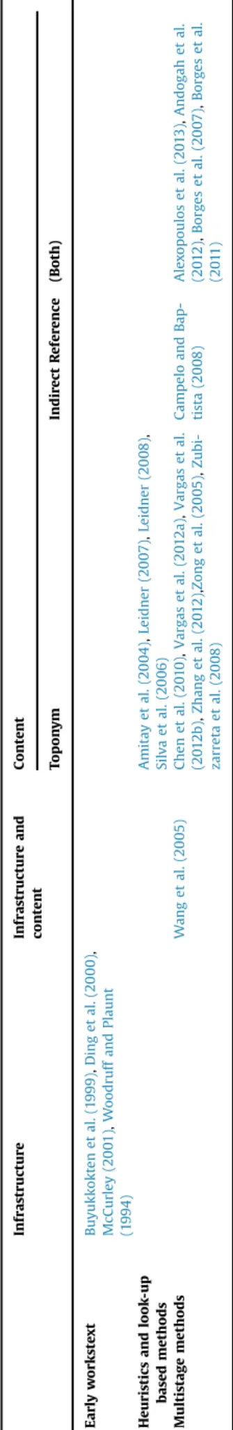
Table 1summarizes the works that deal directly or indirectly with the GSR problem.
More recent works tend to concentrate on a single task in the GSR problem, due to the increasing complexity of the proposals. The focus on single tasks allows for more compartmentalized so-lutions, with sets of techniques directed at each part of the pro-blem. Solutions for each task are discussed in the next sections.
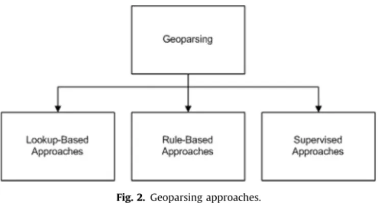
4.2. Geoparsing solutions
This section proposes a classification of the most representative methods found in the literature for geoparsing (Fig. 2). There are three main groups of geoparsing methods: lookup-based, rule-based and machine learning-based (supervised) (Leidner and Lie-berman, 2011). For thefirst two categories, methods are further classified as language-dependent or language-independent. Su-pervised methods are generally language-independent while most other methods are language-dependent. Some authors use con-sider only two categories of extraction techniques, machine learning and rule-based approaches (Habib et al., 2013), instead of the three mentioned above (Leidner and Lieberman, 2011).
In thelookup-basedapproach, each document is analyzed, and each candidate word or set of words is matched against some external data source, such as a gazetteer, an ontology or a data-base. The quality of the external reference data has a direct impact in the quality of the results. If the resource is incomplete, or if there is much ambiguity, the method can lead to false positives and false negatives. Methods are language dependent if the ex-ternal data sources are likewise language-dependent, and multi-lingual reference data can be used to promote language independence.
There are several lookup-based proposals in the literature, which basically use heuristics to identify candidate strings, and then compare them to a reference dataset (Alexopoulos et al., 2013;Amitay et al., 2004;Chen et al., 2010;Clough, 2005; Pouli-quen et al., 2006; Purves et al., 2007; Zubizarreta et al., 2008). There are also more complex proposals using a more varied strategy applied for obtaining candidates. Borges et al. (2007,
2011) use an ontology and regular expressions in the task of geoparsing both for toponyms and indirect references, along with a gazetteer. Similarly,Shi and Barker (2011)use a combination of gazetteer and linguistic heuristics (prepositions near the toponym and spatial relationship terms, sometimes calledspatial preposi-tions) (Mark, 1989) to geoparse for elements such as provider lo-cation and domain, markup components that contain coordinates, indirect references (postal codes, phone numbers) and toponyms. Rule-basedmethods use some heuristics and a set of symbolic rules, such as regular expressions or context-free grammars. Both heuristics and the rules are encoded in domain-specific language, resulting in, most cases, language-dependent methods.Woodruff and Plaunt (1994) pioneered the use of a rule-based method to geoparse texts, looking for place names near lexical constructs that
indicate spatial position. Silva et al. (2006) and Lieberman and Samet (2011) use a part of speech (POS) tagger to find proper nouns, since place names tend to be capitalized. These works are language-dependent, built for texts in English. Twaroch et al. (2008)also use regular expressions andfilters tofind place names. On the other hand,Pouliquen et al. (2004)present a rule-based approach for geoparsing multilingual texts. First they try to discover in which language a text is written, using an n-gram-based language guesser. Then, a set of regular expressions is created tofind all pos-sible place names–countries and cities–including suffixes and other combinations. This is necessary because the same place name may have different spellings in different languages.
Machine learning-basedmethods are built using a training an-notated corpus containing the text associated to the expected set of related places. The annotated corpus is then used to train an algorithm, using features such as infrequent strings, length, capi-talization and other features. After that, the method runs on a corpus of unannotated documents and the same features are computed to decide on the association of places and documents. Techniques such as support vector machines (SVM), conditional random fields (CRF) and hidden Markov models (HMM) can be used to solve the geoparsing step.
SVM is a supervised machine learning algorithm used in data mining tasks, such as classification and regression analysis. In the SVM model, the representation of examples to be classified is done by mapping points in space, so instances of different categories can be clearly separated by a hyperplane. Then, new examples are mapped into the same space, hence their categories can be pre-dicted (Hearst, 1998). SVM can work with two (binary SVM) or more (multi-class SVM) classes. Another example of a machine learning classifier is HMM, which is a sequence classifier. More precisely, HMM is a ubiquitous tool for representing probability distributions over sequences of observations (Fujiwara et al., 2009). HMM classifies single objects into classes, considering the characteristics of objects in the neighborhood. Similar to HMM, the CRF approach is also a supervised learning technique in which statistical models using sequence data are built. It uses an un-directed graphical model that defines a log-linear distribution over sequences, given a particular sequence.
Chasin et al. (2013)present and experimentally compare three machine learning methods tofind toponym candidates: (1) a SVM approach, (2) a HMM implemented by the LingPipe10library, and (3) the NER tool designed by the Stanford Natural Language Pro-cessing Group,11which uses the CRF algorithm. In order to decide whether each candidate is actually a toponym, a lookup is made using Google Geocoder.12
An example of a supervised method is presented byHabib et al. (2013). They use HMM and SVM to extract toponyms from a set of
descriptions of holiday homes. HMM, trained using manual an-notations, is used to extract candidate toponyms from the docu-ment. Candidates are then matched against data from GeoNames, generating two sets of features (positive and negative candidates) that are used to train a SVM classifier. SVM is then used as a dis-ambiguation technique, reinforcing the results from the original extraction. The method is language-independent, as demonstrated by experiments involving texts in English, German and Dutch. In a different approach,Nissim et al. (2004)use the Curran and Clark maximum entropy tagger (Curran and Clark, 2003) to recognize location names in historical descriptions of Scotland. The tagger, as a supervised approach, is trained using 10-fold cross-validation on an annotated dataset. The method shows significant improvement in precision, recall and f-score over a lookup-based method that used a custom-built Scottish gazetteer.
There is a complicating factor in the analysis of the various methods described in this section. Results from lookup-based methods are highly dependent on the external reference source, and each proposal potentially uses a different one, including cus-tom-built gazetteers. Rule-based approaches use resources such as regular expressions and linguistic heuristics, custom-built in many cases, with language variations and adaptations that are tuned to particular problems. Supervised methods require labeled training data, and no standard for comparing the performance of methods has emerged so far. Notice, however, that Rule-based and su-pervised methods also use external data, thus their results is also dependent on the quality of reference data source or annotated corpus.
Table 2summarizes the works that deal with solutions for the geoparsing step.
4.3. Reference resolution solutions
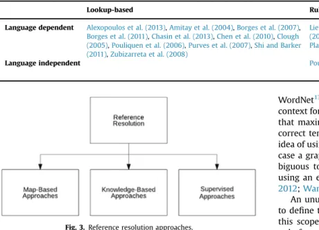
We classify the methods for the reference resolution in three categories, following Buscaldi and Rosso (2008): map-based ap-proaches; knowledge-based approaches; and data driven or su-pervisedmethods. We propose expanding the scope of map-based approaches, which involve geometries and distances, to include other GIS data, techniques and functions. If more complex geo-metric representations are available, methods can move beyond using simple positions and distances to use topological relation-ships for disambiguation (Fig. 3).
Methods and techniques classified as map-based approaches are those that use some geometric algorithms or topological functions, such asdisjoint,union,interception, and others. Knowl-edge-based approaches are based on the hypothesis that topo-nyms appearing together in text are related to each other, and that this relation can be extracted from gazetteers and knowledge bases such as Wikipedia (Habib et al., 2013). Supervised methods are those based on standard machine learning techniques.
Fig. 3shows the proposed classification for reference resolution approaches. Reference resolution proposals are very similar to each other. They usually distinguish themselves only on the geo-metric algorithm or topological function used.
The rationale behind using proximity as the basis of heuristics for disambiguation in map-based approaches is the well-known First Law of Geography (Tobler, 1970), i.e., the assumption that
“everything is related to everything else, but near things are more related than distant things”. The degree of belief in the semantics (e.g.“Calgary, Alberta, Canada”or“Calgary, Zimbabwe”) of an am-biguous toponym (e.g.“Calgary”) can be measured based on vici-nity measurements. In other words, the toponym is resolved to the place that is closest to other resolved toponyms (Shi and Barker, 2011).
For instance,Smith and Crane (2001)use the concepts of cen-troid in a map and calculate the distance of the cencen-troid to the Fig. 2.Geoparsing approaches.
10http://alias-i.com/lingpipe/demos/tutorial/ne/read-me.html
11http://nlp.stanford.edu
candidates to disambiguate the toponyms. Vargas et al. (2012a,
2012b)use a similar function based on a polygon containing the unambiguous entities, and Zong et al. (2005)use a gazetteer as support.
Leidner et al. (2003)define adisambiguating contextas a region in whose confines most unresolved toponyms become unique. This can be implemented using a GIS function. He also uses the“one reference per discourse”heuristic.
A match against a gazetteer represents the simplest example of theknowledge-basedapproach (Chen et al., 2010;Pouliquen et al., 2004). Other simple examples try to use some semantic in-formation present on the external knowledge source to dis-ambiguate the references, such as population information (Rauch et al., 2003) or information about the administrative region and country names related to the ambiguous toponyms (Olligschlaeger and Hauptmann, 1999). Most work on reference resolution relies on using heuristics and custom-built rules which are knowledge source approaches since they use some gazetteer or database as support (DeLozier et al., 2015). For instance,Amitay et al. (2004)
use a sequential algorithm that applies several heuristics to each ambiguous toponym. Thefirst one looks for tokens in the vicinity and checks if they are able to uniquely qualify the toponyms; the second one solves the ambiguity by assuming as correct the geo-graphic entity with the largest population. Next, the“one reference per discourse” heuristics is used, followed by another heuristic based on the notion of a disambiguating context. As opposed to
Leidner et al. (2003), Amitay et al. (2004) use a administrative boundary hierarchy form external sources as a disambiguating context, with no actual map data involved.
Some works try to assign values, scores or probabilities to disambiguation candidates. This idea can be combined with some heuristics and/or classification rules (Alexopoulos et al., 2013; Li et al., 2006;Silva et al., 2006;Volz et al., 2007), or make use of variations of well-know algorithms, such as the GeoRank (Zhang et al., 2012) which uses the same voting process as in PageRank.
Clough (2005)andPurves et al. (2007)explore the hierarchy of the external source to provide a default sense to an ambiguous toponym.
Other proposals use an external knowledge source and also include some algorithms that work on the string close to the ambiguous toponym in the text.Buscaldi and Rosso (2008) use
WordNet13and a conceptual-density-based approach, selecting a context for each ambiguous toponym and building a sub-hierarchy that maximizes the conceptual density that helps to choose the correct term for the toponym.Li et al. (2002,2003)also use this idea of using co-occurring words and build a data structure, in this case a graph, that allows to calculate the best match for the am-biguous toponym. Other works also deal with the core idea of using an external knowledge source and local context (Sobhana, 2012;Wang et al., 2010).
An unusual approach, byAndogah et al. (2012), proposesfirst to define the geographic scope of the document and then to use this scope with other heuristics to disambiguate the toponyms, only for geo-geo ambiguity. To solve the geo/non-geo cases, they use the Alias-i LingPipe14NER tool.
In thesupervisedapproach, most of the works follow the usual Machine Learning approach: build a training set composed by disambiguated toponyms (in a manual or automatic way) and then run a standard learning algorithm, such as Naïve Bayes classifiers (Smith and Mann, 2003), Bayesian classifiers (Adelfio and Samet, 2013), Random Forests (Lieberman and Samet, 2012) or clustering methods (Habib and van Keulen, 2012). Instead of using un-ambiguous toponym to train the machine learning algorithms, some works use indirect supervision to create training data from links and Wikipedia annotations (Santos et al., 2014;Speriosu and Baldridge, 2013)
A gazetteer-based statistical classifier is used by Garbin and Mani (2005). The gazetteer is used to match the toponyms found in the text and also to train the machine learner over some fea-tures, including the class of all the toponyms in the document, i.e., national capital, political region or populated place, and the terms within three words from the ambiguous toponym. The system determines the class of the ambiguous toponyms and uses some preferences to disambiguate them.
A comparison between a map-based approach and a knowl-edge-based approach was made by Buscaldi and Rosso (2008). Both methods use the georeferenced version of WordNet. Thefirst one calculates centroids considering each ambiguous candidate and unambiguous places. The centroid with the smallest accu-mulated distance is used to identify a preferred candidate. The second one exploits the structure of WordNet to solve ambiguity. They conclude that the knowledge-based approach was better when a small context was used, such as a sentence or a paragraph, and the map-based approach obtained best results when the context was the whole document.
The number of works that deal with the reference resolution problem is very large. However, as in the case of geoparsing, comparing all these methods is difficult, even though there are many similarities. Most solutions require an external knowledge source. As a result, the quality of the external dataset is crucial to achieve better results in reference resolution. For instance, ac-cording toVasardani et al. (2013), the nature of each gazetteers' Table 2
Solutions to the Geoparsing step.
Lookup-based Rule-based Supervised
Language dependent Alexopoulos et al. (2013),Amitay et al. (2004),Borges et al. (2007),
Borges et al. (2011),Chasin et al. (2013),Chen et al. (2010),Clough
(2005),Pouliquen et al. (2006),Purves et al. (2007),Shi and Barker
(2011),Zubizarreta et al. (2008)
Lieberman and Samet (2011),Silva et al.
(2006),Twaroch et al. (2008),Woodruff and
Plaunt (1994)
Language independent Pouliquen et al. (2004) Habib et al. (2013),
Nis-sim et al. (2004)
Fig. 3.Reference resolution approaches.
13http://wordnet.princeton.edu
core components may create problems such as the lack of un-official and vernacular names and the absence of a common structure among the gazetteers.
There are some efforts in creating and enriching these external sources.Machado et al. (2011)proposed an ontological gazetteer that includes geographic elements such as spatial relationships, concepts and terms related to places. Moura and Davis (2014)
proposed the creation of a gazetteer from the integration of linked data sources, and found several issues with the quality of the data in such reference databases, including incompleteness and classi-fication errors. Problems that derive from the quality of reference data have been reported for address geocoding problems (Hart and Zandbergen, 2013; Zandbergen, 2011; Ahlers, 2013), which are quite similar to GSR as to their methodology. Such works confirm that the accuracy of the results is fundamentally dependent on the completeness and accuracy of the reference dataset, although address geocoding uses a curated set of valid addresses or address ranges per thoroughfare segment (Davis and Fonseca, 2007). Nevertheless, the influence of the quality, completeness, level of detail and nature of the reference data source for these problems has not been assessed so far.
Table 3 summarizes the works that deal with the reference resolution step.
4.4. Solutions for grounding references
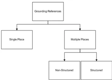
Solutions for grounding references are classified according to the form in which the geographic scope is generated and pre-sented to the users and systems instead of considering the algo-rithms and techniques used tofind the solution. References can be grounded as a one or more pairs of geographic coordinates. Be-sides that, another aspect that must be considered is the granu-larity of the solution, e.g., if the solution will be presented at the country, state or city level.Fig. 4presents a taxonomy to organize these types of grounding.
The results of the grounding references step can be divided into those that consider a single place as the geographic scope of the document, and those that can generate multiple places to compose the scope. The latter can be divided into results that use some structure to inform the scope (structure) and the results that not reflect any kind of structure (unstructured).
The single place category includes techniques that consider the most representative place to be the geographic scope. It also uses some kind of generalization, grouping the places found in the document in a single place higher in a geographic or adminis-trative hierarchy. This category includes the simplest alternatives, which just consider a single pair of coordinates to represent the geographic scope of documents (Amitay et al., 2004;Borges et al., 2011;Buyukkokten et al., 1999;Ding et al., 2000;McCurley, 2001;
Woodruff and Plaunt, 1994). Other alternatives (Silva et al., 2006;
Wang et al., 2005) use a data structure to calculate the importance of the toponyms identified in the geoparsing step, but they con-sider only the most important toponym found as the geographic scope.
Most proposals that generate multiple places as a result define some data structure to organize them, such as a tree (Chen et al., 2010;Zhang et al., 2012;Campelo and Baptista, 2008) or a graph (Zubizarreta et al., 2008). Trees are used to represent a hierarchy of spatial subdivisions, so that parent nodes spatially contain their children. Moving up in the tree, it is possible to go from individual references to a single all-encompassing one that serves as a gen-eral result.Andogah et al. (2012)propose a particular data struc-ture based on the assumption that “places of the same type or under the same administrative jurisdiction or adjacent to each other are more likely to be mentioned in a given discourse unit”. Another alternative is a simple list of locations related to the text (Alexopoulos et al., 2013;Vargas et al., 2012b;Zong et al., 2005), in no particular ordering, which we group as non-structured ap-proaches.Table 4summarizes the forms in which the geographic scope is generated and presented.
Table 3
Solutions to the reference resolution step.
Map-based Knowledge-Based Supervised
Leidner et al. (2003),Shi and Barker (2011),
Smith and Crane (2001),Vargas et al.
(2012a),Vargas et al. (2012b),Zong et al.
(2005)
Alexopoulos et al. (2013),Amitay et al. (2004),Andogah
et al. (2012),Buscaldi and Rosso (2008),Chen et al. (2010),
Clough (2005),DeLozier et al. (2015),Li et al. (2002),Li et al.
(2003),Li et al. (2006),Olligschlaeger and Hauptmann
(1999),Pouliquen et al. (2004),Purves et al. (2007),Rauch
et al. (2003),Silva et al. (2006),Sobhana (2012),Volz et al.
(2007),Wang et al. (2010),Zhang et al. (2012)
Adelfio and Samet (2013),Garbin and Mani (2005),
Habib and van Keulen (2012),Lieberman and Samet
(2012),Santos et al. (2014),Smith and Mann (2003),
Speriosu and Baldridge (2013) Fig. 4. Grounding references.
Table 4
Forms of the Geographic Scope.
Single place Multiple places
Non-Structured Structured
Amitay et al. (2004),Borges
et al. (2011),Buyukkokten
et al. (1999),Ding et al.
(2000),McCurley (2001),
Silva et al. (2006),Wang
et al. (2005),Woodruff and
Plaunt (1994)
Alexopoulos et al.
(2013),Vargas et al.
(2012a),Vargas
et al. (2012b),Zong
et al. (2005)
Andogah et al. (2012), Campelo and Baptista
(2008),Chen et al.
(2010),Zhang et al.
(2012),Zubizarreta
5. Conclusions and future work
The goal of this survey was to provide a comprehensive and structured view on contributions to the geographic scope resolu-tion problem. We presented a definiresolu-tion of the GSR problem, di-viding the problem in three steps:geoparsing,reference resolution and grounding references. Solutions to the first two steps were organized according to the method used, and proposals to the third step were organized according to the type of output pro-duced. We would like to emphasize that the classes in each group of solutions are not exclusive, since in more complex solutions one of the steps might include characteristics of more than one class. In this way, some works could be classified in more than one class. Even though the summary tables classify each work according to its main focus, text in each section indicates works that cover other aspects of the problem as well.
One of the characteristics that stood out analyzing the solutions found in the literature was the use of external reference sources. The most common source used was a gazetteer, both for the global solutions and for geoparsing and reference resolution. Even some methods that rely on machine learning algorithms and heuristics use a gazetteer. The quality and the coverage of the gazetteer have an important role in the quality of the solution.
We also presented a list of related application areas that can benefit from the determination of the geographic scope of docu-ments. Such areas range from search engines to social media, in-cluding social network user location inference and document classification according to spatial criteria. It should be noted that the list of applications and areas is not exhaustive. There are other works that only slightly differ from the subject of this article, but are closely related. For example,Wang et al. (2005)deal with three different kinds of geographic scope (provider, content and ser-ving).Gravano et al. (2003)focus on determining the geographic scope of queries considering the locality issue, i.e., if the query is global or local.Anastácio et al. (2009)also deal with the locality issue to perform document classification. Quercini et al. (2010)
highlight the difference between the geographic scope of a docu-ment and the geographic scope of readers; the former is related to the main geographic area of interest of a document, while the latter regards the audience that is interested in news about a specific place, i.e., a place geographically close to the reader.
Although the problem has been studied for some years and many solutions have been proposed in the literature, there are still several inconsistencies, mostly regarding terminology variations of the concepts related to the GSR problem. We suggested the use of some terms and made references to alternative uses.
In short, the main contributions of this survey are a proposal for standardizing the definition of the problem and related con-cepts, along with the classification of the solutions found in the literature to each step of the problem according to characteristics observed in the method.
Numerous research challenges and opportunities still exist, requiring novel solutions to the GSR problem and advances in related areas. First, the scope of a document can be semantically broader than simply a set of locations referenced in the text. As a result, the scope embeds part of the semantics of the document resulting in ageographic semantic scopethat includes not only the explicitly mentioned locations but also the meaning that these references have to the readers of the documents. Second, the creation, maintenance and curation of reference data sources, such as gazetteers, is an essential part of the work in GIR, and should be much more active as a research topic in the future. Finally, it is difficult to compare the existing solutions directly to one another, especially due to the lack of annotated corpora (Wallgrün et al., 2014). Most of the works reviewed in this paper created their own benchmarking data, targeted to their methodologies and solutions.
Acknowledgments
This work was partially supported by FAPEMIG (grant CEX-PPM-00679/15) and CNPq (grants 303532/2015-7, 459818/2014-2 and 401822/2013-3), Brazilian agencies in charge of fostering re-search and development.
References
Adelfio, M.D., Samet, H., 2013. Geowhiz: toponym resolution using common categories.
In: Proceedings of the 21st ACM SIGSPATIAL International Conference on Advances in
Geographic Information Systems, SIGSPATIAL'13, ACM, New York, NY, USA, pp. 532–
535.http://dx.doi.org/10.1145/2525314.2525321.
Ahlers, D., 2013. Assessment of the accuracy of Geonames gazetteer data, In: Proceedings of the 7th Workshop on Geographic Information Retrieval, GIR '13, ACM, New York,
NY, USA, pp. 74–81.http://dx.doi.org/10.1145/2533888.2533938.
Alencar, R.O., Davis Jr., C.A., 2011. Advancing Geoinformation Science for a Changing
World, vol. 1, Springer Berlin Heidelberg, Berlin, Heidelberg, 2011, pp. 461–477 (Ch.
Geotagging Aided by Topic Detection with Wikipedia).http://dx.doi.org/10.1007/
978-3-642-19789-5_23.
Alencar, R.O., Davis Jr., C.A., Gonçalves, M.A., 2010. Geographical classification of
docu-ments using evidence from Wikipedia, In: Proceedings of the 6th Workshop on
Geographic Information Retrieval, GIR '10, ACM, New York, NY, USA, pp. 12:1–12:8.
http://dx.doi.org/10.1145/1722080.1722096.
Alexopoulos, P., Ruiz, C., 2012. Optimizing geographical entity and scope resolution in texts using non-geographical semantic information. In: Proceedings of the 6th In-ternational Conference on Advances in Semantic Processing, SEMAPRO 2012, Think
Mind, Barcelona, Spain, pp. 65–70.〈https://www.thinkmind.org/download.php?arti
cleid¼semapro_2012_3_40_50081〉(accessed: 2016-05-30).
Alexopoulos, P., Ruiz, C., Villazon-Terrazas, B., Gómez-Pérez, J.M., 2013. KLocator: an ontology-based framework for scenario-driven geographical scope resolution. Int. J. Adv. Intell. Syst. 6 (3–4), 177–187, accessed: 2016-05-30.〈http://citeseerx.ist.psu.edu/ viewdoc/download?doi¼10.1.1.683.4748&rep¼rep1&type¼pdf〉.
Amitay, E., Har'El, N., Sivan, R., Soffer, A., 2004. Web-a-where: Geotagging web content, In: Proceedings of the 27th Annual International ACM SIGIR Conference on Research and Development in Information Retrieval, SIGIR '04, ACM, New York, NY, USA, pp. 273–280.http://dx.doi.org/10.1145/1008992.1009040.
Anastácio, I., Martins, B., Calado, P., 2009. Progress in Artificial Intelligence: 14th
Portuguese Conference on Artificial Intelligence, EPIA 2009, Aveiro, Portugal,
October 12–15, 2009. In: Proceedings, Lecture Notes in Computer Science, vol.
5816, Springer, Berlin, Heidelberg, 2009, pp. 598–609 (Ch. classifying
docu-ments according to locational relevance).
http://dx.doi.org/10.1007/978-3-642-04686-5.49.
Anastácio, I., Martins, B., Calado, P., 2009. A comparison of different approaches for as-signing geographic scopes to documents, In: Proceedings of the 1st
InForum-Sim-pósio de Informática, INForum '09, Lisbon, Portugal, pp. 285–296.〈http://xldb.fc.ul.
pt/xldb/publications/Anastacio.etal:AComparisonOf:2009_document.pdf〉(accessed: 2016-05-31).
Andogah, G., Bouma, G., Nerbonne, J., 2012. Every document has a geographical scope.
Data Knowl. Eng 81–82, 1–20.http://dx.doi.org/10.1016/j.datak.2012.07.002.
Backstrom, L., Sun, E., Marlow, C., 2010. Find me if you can: improving geographical prediction with social and spatial proximity. In: Proceedings of the 19th
Interna-tional Conference on World Wide Web, WWW '10, ACM, New York, NY, USA, pp. 61–
70.http://dx.doi.org/10.1145/1772690.1772698.
Baeza-Yates, R.A., Ribeiro-Neto, B., 1999. Modern Information Retrieval. Addison-Wesley Longman Publishing Co., Inc., Boston, MA, USA.
Borges, K.A.V., Laender, A.H.F., Medeiros, C.B., Davis Jr., C.A., 2007. Discovering geographic locations in Web pages using urban addresses. In: Proceedings of the 4th ACM Workshop on Geographical Information Retrieval, GIR '07, ACM, New York, NY, USA,
pp. 31–36.http://dx.doi.org/10.1145/1316948.1316957.
Borges, K.A.V., Davis Jr., C.A., Laender, A.H.F., Medeiros, C.B., 2011. Ontology-driven
dis-covery of geospatial evidence in web pages. GeoInformatica 15 (4), 609–631.http:
//dx.doi.org/10.1007/s10707-010-0118-z.
Buscaldi, D., Rosso, P., 2008. A conceptual density-based approach for the disambiguation
of toponyms. Int. J. Geogr. Inf. Sci. 22 (3), 301–313.http://dx.doi.org/10.1080/
13658810701626251.
Buscaldi, D., Rosso, P., 2008. Map-based vs. knowledge-based toponym disambiguation. In: Proceedings of the 2nd International Workshop on Geographic Information
Re-trieval, GIR '08, ACM, New York, NY, USA, pp. 19–22.http://dx.doi.org/10.1145/
1460007.1460011.
Buyukkokten, O., Cho, J., Garcia-Molina, H., Gravano, L., Shivakumar, N., 1999. Exploiting geographical location information of web pages. In: ACM SIGMOD Workshop on The
Web and Databases (WebDB'99), pp. 91–96.〈http://ilpubs.stanford.edu:8090/415/1/
1999-5.pdf〉(accessed: 2016-05-30).
Campelo, C.E.C., Baptista, C.S., 2008. Geographic scope modeling for Web documents. In: Proceedings of the 2nd International Workshop on Geographic Information
Re-trieval, GIR '08, ACM, New York, NY, USA, pp. 11–18.http://dx.doi.org/10.1145/
1460007.1460010.
Cardoso, N., Silva, M.J., Santos, D., 2008. Handling implicit geographic evidence for geographic IR. In: Proceedings of the 17th ACM Conference on Information and
Knowledge Management, CIKM '08, ACM, New York, NY, USA, 2008, pp. 1383–1384.
http://dx.doi.org/10.1145/1458082.1458291.
Cardoso, N., 2011. Evaluating geographic information retrieval. SIGSPATIAL Spec. 3 (2), 46–53.http://dx.doi.org/10.1145/2047296.2047307.
Chasin, R., Woodward, D., Witmer, J., Kalita, J., 2013. Extracting and displaying temporal
and geospatial entities from articles on historical events. Comput. J. 57 (3), 403–426.