www.nat-hazards-earth-syst-sci.net/11/2371/2011/ doi:10.5194/nhess-11-2371-2011
© Author(s) 2011. CC Attribution 3.0 License.
and Earth
System Sciences
High resolution tsunami modelling for the evaluation of potential
risk areas in Set ´ubal (Portugal)
J. Ribeiro, A. Silva, and P. Leit˜ao
HIDROMOD, Modelac¸˜ao em Engenharia, Lisboa, Portugal
Received: 31 August 2010 – Revised: 14 July 2011 – Accepted: 19 July 2011 – Published: 26 August 2011
Abstract. The use of high resolution hydrodynamic mod-elling to simulate the potential effects of tsunami events can provide relevant information about the most probable inun-dation areas. Moreover, the consideration of complemen-tary data such as the type of buildings, location of priority equipment, type of roads, enables mapping of the most vul-nerable zones, computing of the expected damage on man-made structures, constrain of the definition of rescue areas and escape routes, adaptation of emergency plans and proper evaluation of the vulnerability associated with different areas and/or equipment.
Such an approach was used to evaluate the specific risks associated with a potential occurrence of a tsunami event in the region of Set´ubal (Portugal), which was one of the areas most seriously affected by the 1755 tsunami.
In order to perform an evaluation of the hazard associated with the occurrence of a similar event, high resolution wave propagation simulations were performed considering differ-ent potdiffer-ential earthquake sources with differdiffer-ent magnitudes. Based on these simulations, detailed inundation maps asso-ciated with the different events were produced. These results were combined with the available information on the vulner-ability of the local infrastructures (building types, roads and streets characteristics, priority buildings) in order to impose restrictions in the production of high-scale potential damage maps, escape routes and emergency routes maps.
1 Introduction
Since the 2004 Indian Ocean tsunami, the awareness of the European governments on the risks associated with the po-tential occurrence of a tsunami event has being growing. An example of this is the tsunami warning system (TWS) that
Correspondence to:J. Ribeiro ([email protected])
has been implemented by the Intergovernmental Coordina-tion Group for the Tsunami Early Warning and MitigaCoordina-tion System in the North-Eastern Atlantic, the Mediterranean and connected seas.
Similar systems have been developed and are operational in other regions, such as the Pacific Tsunami Warning Sys-tem (PTWS), the West Coast and Alaska Tsunami Warn-ing Centre (WC/ATWC), the ICG/CARIBE-EWS (which has been conceived with a multi-hazard approach and focused on all coastal hazards) or the Indian Ocean Tsunami Warn-ing System (IOTWS), among others. Most of these systems were designed to cover large areas, but in many places there is a need to establish a regional warning system due to the short time available for an effective response. Such is the case of Portugal, where the average travel time for a tsunami originating in the most probable areas, the South and south-west coasts of the Iberian Peninsula, takes less than 15 min to reach the Portuguese southern coast as discussed in Sect. 4.
In order to improve the capacity of response for a tsunami event, a Portuguese Tsunami Warning System (PtTWS) is being developed by the Meteorological Institute in collabo-ration with D. Lu´ıs Institute and the Joint Research Centre (JRC) and it has been designed to detect tsunami originated from earthquakes. A dense seismic network that operates 24 h a day, 7 days a week, along with the Tsunami Analysis Tool (TAT), that explores a database of over 6500 scenarios, allows a first evaluation of the tsunami danger by an operator within 5 min of the event onset (Matias et al., 2010).
vulnerable areas associated with an earthquake or flooding events, the tsunami hazard is still not seen as a high risk event and there is a lack of association of an earthquake with a tsunami event. In view of these results, one must conclude that it is imperative to develop public awareness concerning this issue.
Conversely, although the Civil Protection Authority shows a high level of preparedness to deal with major hazards such as floods or fires, it does not have specific plans to respond to a tsunami event (or to a more probable combined earthquake-tsunami event). For instance, there are detailed maps identi-fying the most vulnerable areas and escape routes in case of the occurrence of a flood, but there is no similar information for the occurrence of a tsunami. In order to cover this gap, the identification and mapping of the most vulnerable areas using high resolution models can produce a reliable input in the elaboration of evacuation and rescue plans in the case of a tsunami event.
Such simulations were carried out for the area of Set´ubal, on the western Portuguese coast, using the MOHID wa-ter modelling system (Malhadas et al., 2009) following a methodology common to 5 sites that were investigated within the framework of the SCHEMA project (Set´ubal in Portu-gal, Varna in Bulgaria, Catania in Italy, Rabat in Morocco, and Mandelieu in France). In order to properly evaluate the robustness of MOHID and other models to properly simu-late the propagation of a tsunami event, a benchmark based on data available from the 2004 Indian Ocean tsunami im-pact on the Seychelles islands was performed using 5 differ-ent models: MOHID water modelling system, Community Model Interface for Tsunami (ComMIT) base on the Method of Splitting Tsunami model (MOST), UBO-TSUFD model, FUNWAVE model and the TIDAL model. The tide gauge recorder from the Pointe Larue station located at Mah´e Is-land international airport was used to compare the results of the water level and time of arrival measured and computed by the models. Also, the results of maximum inundation depths and current speed were used to benchmark the various mod-els used in the SCHEMA project (Lessons learnt from the Asia test site, www.schemaproject.org/spip.php?rubrique4).
2 Study site
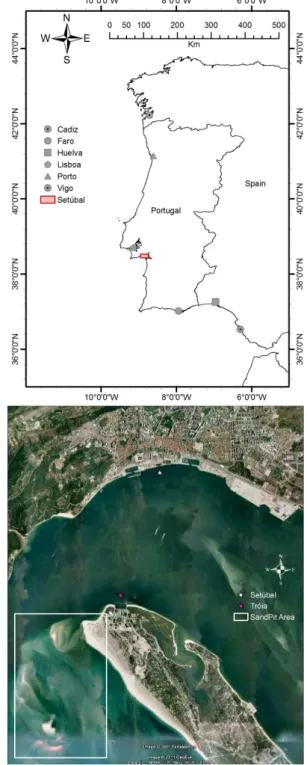
The study site is located in the Sado estuary region, on the western coast of Portugal (Fig. 1), and it includes two differ-ent areas: Set´ubal city and Tr´oia peninsula.
The Sado Estuary is located 40 km south of Lisbon and is the second largest estuary in Portugal, with an area of ap-proximately 24 000 ha. Most of the estuary is classified as a natural reserve (Reserva Natural do Estu´ario do Sado). Ex-ception is made for the city of Set´ubal, its port, and a con-siderable part of its surrounding area. With a number of in-habitants of some 120 000 and a land area of 170 km2, the population is concentrated mainly in the city of Set´ubal.
Fig. 1.Location of the test site.
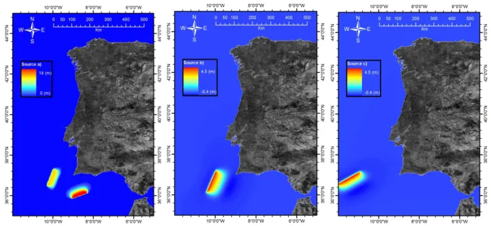
Fig. 2. Source(a): considered the most destructive simulated, Baptista et al. (2003). Source(b): MPF event, considered the moderated case, Omira et al. (2009). Source(c): GBF event, considered the weakest, Omira et al. (2009).
Table 1.The considered scenarios, the fault for each scenario, the length and the width of the faults, depth from the sea bottom to the top of the fault and the moment magnitude.
Scenario L W Epicentre coordinates D Slip Strike Dip Rake µ Mω
(Km) (Km) Lon Lat (Km) (m) (◦) (◦) (◦) (Pa)
MPTF 105 55 – – – 20 21.7 24 – –
>8
G. Bank 96 55 – – – 20 70 45 – –
MPF 129 70 −9.890 36.574 4.0 8.0 20.0 35 90 3.0×10¹⁰ 8.1
GBF 127 60 −11.332 36.665 5.0 8.3 233.0 35 90 3.0×10¹⁰ 8.1
2.1 1755 Tsunami
There has been a significant number of tsunami events regis-tered on the Atlantic coast of the Iberian Peninsula (Baptista and Miranda, 2009). Among them is the well-known 1755 earthquake and tsunami event.
The 1755 earthquake took place on Saturday, 1 Novem-ber 1755, the Catholic holiday of All Saints’ Day, at approx-imately 09:30 in the morning. The earthquake is considered to have had a seismic intensity of X–XI on the Mercalli In-tensity Scale, and it was felt all over Europe (Baptista et al., 1998a). Its magnitude is considered to have been of the or-der of 8.5 with the epicentre located south/southwest of Cape S˜ao Vicente near the Gorringe Bank although there still per-sists a degree of uncertainty about the precise location of the epicentre and the focal mechanism (Baptista et al., 1998b).
The subsequent tsunami caused by the earthquake pro-duced a large inundation and enhanced the destruction in Lisbon downtown and other coastal villages such as S´etubal.
According to available descriptions, as a result of the com-bined action of the earthquake and the tsunami, the city walls collapsed which increased the damage and destruction of the inner city. According to a description of the time “the Sea destroyed the city walls entering the city almost a quarter of a mile, carrying 2 boats for more than 50 steps (∼45 m) in land” (Mendonc¸a, 1758), “Letters by the last post notify that no traces are left of St Ubes [Set´ubal], the repeated shocks and the vast surf of the sea having jointly concurred to swal-low it up. It could withstand them, as it was situated at the head of a small gulf formed by the tide at the mouth of the [Sado]. . .” URBAN, (1755).
Table 2.Domain Resolution.
Level Grid Grid Size
Resolution Lines×Columns
1 0.01◦ 1000×700
2 250 m 269×388
3 50 m 224×249
4 10 m 300×650
5 2 m 396×936
and all the territories adjacent to the water: the main de-struction occurred in this village of Set´ubal in which almost all the houses and churches were destroyed, including our church of S. Julian (...). and more than four thousand people died in this village, not only as a consequence of the earth-quake, but due to the action of the sea which on this fatal day inundated the village three times (...).”
3 Hydrodynamic model
In order to evaluate the potential effects of a tsunami event on the downtown area of Set´ubal and Tr´oia peninsula, a number of numerical simulations considering different po-tential earthquake sources have been performed using MO-HID modelling system, which is a three-dimensional finite volume model developed by IST (Technical University of Lisbon) and Hidromod (Martins et al., 2001). MOHID has the ability to simulate flows over complex bathymetries and it has been widely used to simulate flows ranging from shallow coastal systems (Vaz et al., 2009) to deep ocean environments (Riflet et al., 2008). The model uses Navier-Stokes primi-tive equations with Boussinesq and hydrostatic assumptions. MOHID is a 3-D baroclinic model. However, in this case due to the barotropic nature of the processes involved and in order to increase computational efficiency, a 2-D approach (only one vertical layer) was followed. The model takes into consideration the existence of moving boundaries which allows the simulation of the inundation processes (Martins et al., 2001). At the bottom, advective fluxes are imposed as null and the diffusive flux of momentum is estimated by means of a bottom stress calculated by a non-slip method with a quadratic law that depends on the near-bottom veloc-ity. This quadratic law is derived from the logarithmic law of the wall near boundaries characteristic of boundary lay-ers, as the bottom velocities are located half a grid box above the bottom. This term is calculated semi-implicitly following Backhaus (1983) for numerical stability reasons. The model solves a semi-implicit ADI algorithm to compute the water level evolution with two time levels per iteration. The two components of the horizontal velocity are globally centred in timet+dt/2 leading to a second order time accuracy (Martins
et al., 2001). MOHID allows the user to construct a tree of
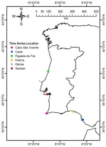
Fig. 3.Time series location points for the Portuguese coast.
nested models with no limitations on the number of nesting levels (Braunschweig et al., 2004). Between nesting levels a radiation boundary condition proposed by Flather (1976) is used. A one-way nesting approach with interpolation in the horizontal and linear interpolation in the vertical and in time is followed. A detailed description of the nesting methodol-ogy is presented in Leit˜ao et al. (2005).
The system also allows adding the tide level based on global tide solution FES2004 (Lyard et al., 2006).
3.1 Simulations
In this study, three different possible tsunami sources corre-sponding to different faults and therefore different initial sea level displacements were simulated. These sources (Fig. 2, Table 1) representing high, medium and low destructive con-ditions were adopted from different proposals available in the literature regarding possible earthquake sources south-west of the Portuguese coast (Omira et al., 2009; Baptista et al., 2003).
Table 3. Results of simulated events for Set´ubal.
Scenario Tide Travel Time Wave height Max. Water Max. Inundation Max. Velocity Water Column (min) (m) Level Inland (m) Distance (m) Inland (m s−1) (m)
MPTF High 30 6.87 7–8 859 >3 3
G. Bank Low 30 4.98 5–6 206 1.5–2 1.5–2
MPF High 32 5.19 4–5 578 1.5–2 1.5–2
Low 32 3.26 No Inundation
GBF High 35 5.05 5–6 419 1–1.5 0.5–1
Low 35 3.13 No Inundation
Fig. 5.Set´ubal Inundation areas considering topography only (top) and including buildings (bottom).
and the Marquˆes de Pombal Bank Fault, are based on a study done by Omira et al. (2009) regarding the design of a Sea-level Tsunami Detection Network for the Gulf of Cadiz.
The simulations consisted in four level nested grids with a fifth level only for the city of S´etubal that has incorporated the detailed building information.
For the first level, the SRTM 30 data were used to build a computational grid with a resolution of 0.01◦
(Table 2). The second level (250 m resolution grid) is based on data re-trieved from a combination of nautical charts and acoustic surveys. For the third level, a regular grid with 50 m reso-lution was prepared using a combination of nautical charts and mostly acoustic surveys. For the fourth level, a 10 m resolution grid using detailed bathymetric information of the navigation channels obtained by acoustic surveys was set up. The lowest level located at the city of Set´ubal consists of a 2 m resolution grid including the detailed bathymetry of the navigation channels and the information on the building char-acteristics.
Two tide levels, referenced to the Portuguese hydrographic zero, were selected, given that tide level plays a most relevant role in the potential inundation areas: a high tide situation corresponding to a 3.8 m water level and a low tide situation corresponding to a 1.8 m water level, all altitudes referred to hydrographic zero.
Fig. 6. Damage calculated by the Damasche tool for the Set´ubal and Tr´oia buildings.
For the region of Set´ubal and Tr´oia, a survey of the build-ing characteristics, roads, parkbuild-ing and marinas was done us-ing Google Earth, Bus-ing (for 3-D view) and local photog-raphy. The building vulnerability classification as regards tsunami hazard was performed according to the classification adopted in SCHEMA that is principally derived from Leone et al. (2006), but has been completed and enlarged in order to include at least all constructions present in all test sites of the SCHEMA (Scheer et al., 2011). Four main classes of buildings have been defined in the classification, divided into sub-classes on the basis of their structural characteristics of resistance – the lowest class corresponds to light construc-tions (A), masonry construction and not reinforced concrete constructions (B, C and D), reinforced concrete constructions (E) and the higher class corresponds to other constructions (F and G).
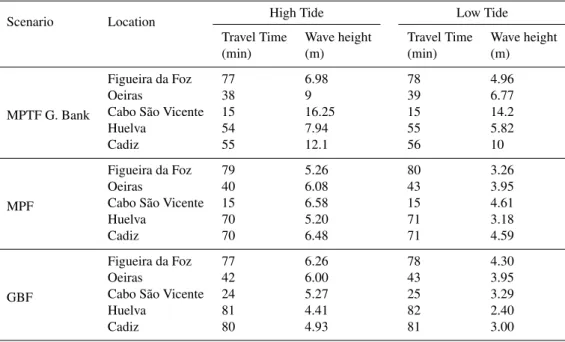
Table 4. Results for selected locations.
Scenario Location High Tide Low Tide
Travel Time Wave height Travel Time Wave height
(min) (m) (min) (m)
MPTF G. Bank
Figueira da Foz 77 6.98 78 4.96
Oeiras 38 9 39 6.77
Cabo S˜ao Vicente 15 16.25 15 14.2
Huelva 54 7.94 55 5.82
Cadiz 55 12.1 56 10
MPF
Figueira da Foz 79 5.26 80 3.26
Oeiras 40 6.08 43 3.95
Cabo S˜ao Vicente 15 6.58 15 4.61
Huelva 70 5.20 71 3.18
Cadiz 70 6.48 71 4.59
GBF
Figueira da Foz 77 6.26 78 4.30
Oeiras 42 6.00 43 3.95
Cabo S˜ao Vicente 24 5.27 25 3.29
Huelva 81 4.41 82 2.40
Cadiz 80 4.93 81 3.00
For the evaluation of the damage suffered by the build-ings, an ArcGis tool developed within the framework of the SCHEMA project was used. The Damage Assessment SCHEMA tool (DamASCHE) is able to assess the potential building damage in an area where a hazard like a tsunami has been modelled and a building vulnerability matrix exists (Tinti et al., 2011). In this case, for the damage assessment the modelled parameter was the water column present in the inundation area.
For the larger computing scales, times series based on the study from Baptista et al. (2003) corresponding to different locations along the Portuguese coast (Fig. 3) were also ana-lyzed.
4 Results and discussion 4.1 Coastal scale
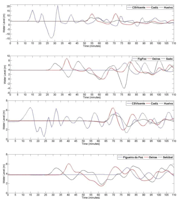
For the most destructive scenario (Fig. 2: source a), the first wave to reach the Sado Estuary (Table 3) has a height of about 7 m and takes about 30 min to travel from the source to Set´ubal. During the simulation period the highest wave registered measures approximately 9 m and occurs one hour and twenty minutes after the beginning of the event. If we consider a set of synthetic mareograms as described in Ta-ble 4, selected to output time series, the most significant one is the Cape of S˜ao Vicente where the wave arrives just fifteen minutes after the beginning of the event with a wave height of 16 m. As for the other relevant locations selected along the
Portuguese coast, Oeiras (near Lisbon), was hit 8 min later than Set´ubal with a 9 m wave.
In the case of the moderated scenario (source b in Fig. 2) event, the first wave took approximately 32 min to reach the Sado Estuary with a height of about 5 m. In comparison with the previous scenario, this is almost 2 m lower. The Cape of S˜ao Vicente registered an initial wave of about 6.5 m, which took approximately fifteen minutes to arrive and the wave ar-rived at Oeiras 8 min after reaching Sado with a height of approximately 6 m and Figueira da Foz registered a wave measuring 5 m 39 min after arriving in Oeiras. In the case of the weaker scenario (source c in Fig. 2), the arrival of the first wave occurs five minutes later than the time that was computed for the first event, corresponding to a travel time of 35 min.
When comparing these results with the gathered informa-tion and the results achieved by Omira et al. (2009) and Bap-tista et al. (2003), the MOHID model generally exhibits sig-nificant agreement. The differences registered may be due to the different models used: SWAN (Mader, 1988) for the first study and an implementation of COMCOT (Liu et al., 1998) for the second, the consideration of high tide and low tide, the grid resolution, and also bathymetric data.
The overall results for all the referred stations can be seen in Table 3 and Fig. 4.
4.2 Local scale
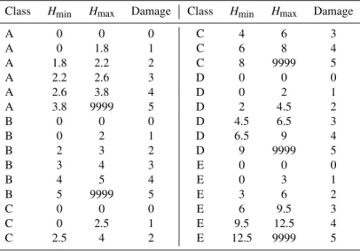
Table 5.Damage Table.
Class Hmin Hmax Damage Class Hmin Hmax Damage
A 0 0 0 C 4 6 3
A 0 1.8 1 C 6 8 4
A 1.8 2.2 2 C 8 9999 5
A 2.2 2.6 3 D 0 0 0
A 2.6 3.8 4 D 0 2 1
A 3.8 9999 5 D 2 4.5 2
B 0 0 0 D 4.5 6.5 3
B 0 2 1 D 6.5 9 4
B 2 3 2 D 9 9999 5
B 3 4 3 E 0 0 0
B 4 5 4 E 0 3 1
B 5 9999 5 E 3 6 2
C 0 0 0 E 6 9.5 3
C 0 2.5 1 E 9.5 12.5 4
C 2.5 4 2 E 12.5 9999 5
Fig. 7.Secondary vulnerability factors zones.
in what concerns the Tr´oia peninsula and Set´ubal city. In the case of Tr´oia Peninsula, the most affected areas are the beach and the tip of the peninsula where the Tr´oia resort is located. The inundation in these areas can reach up to 600 m inland and a water level of 8 to 9 m can be reached around the buildings area. In these areas velocities higher than 3 m s−1
were calculated.
For Set´ubal city, in the case of the stronger event, the max-imum water level lies between 6 and 8 m and one can see that the entire shoreline suffers a relevant impact. The inundation can reach 850 m inland, causing the inundation of the his-torical centre. Here, velocities can range from 0.6 m s−1 to
higher than 3 m s−1, although the analysis of the velocities
must be done with some caution since the values reached in low water or land areas are expected not to be very trustwor-thy due to the limitations of the computational process and the complexity of the geometry.
In Table 4 an overall view of the results on the synthetic mareograms for the different sources can be seen.
For the city of Set´ubal, a fifth computing level including the building information was modelled with the main pur-pose of evaluating to what extent the inclusion of this infor-mation might influence the conclusions concerning the inun-dation areas. In order to do this simulation, it was necessary to build a computational grid with accuracy enough to be able to represent the buildings and the roads in between them. Al-though the results of these simulations need to be carefully analyzed, as they may lead to a false impression of accuracy due to the extreme detail of the flow, they are extremely use-ful if used as a sensitivity analysis. A major conclusion is that the building information can take a significant role, both in the way the inundation occurs and in what concerns its ex-tension (Fig. 5). Comparing the results with topography only and with the extra flow propagation obstacles composed by the buildings, one may, at least, have a confidence interval in what concerns the mapping of the inundation areas.
4.3 Vulnerability analysis
For sources a and b, a comparison of high and low tide impact was done for the local scenarios of Tr´oia and Set´ubal. The maximum of all modelled scenarios at low and high tide was extracted and mapped showing the relevance of the tide level in the inundation areas.
can reach the old town centre affecting administrative build-ings, restaurants and warehouses. The highest level of dam-age (Fig. 6, Table 5) suffered by buildings in Set´ubal for all the scenarios is D2.
In the case of Tr´oia, some A class structures used as beach support infrastructures that can be found on the beach may suffer D5 damage levels. Nevertheless, most of the build-ings in this area can be classified as D or F and only show vulnerability to damages of D1 class level.
In what concerns the routes classification, it was con-cluded that the streets in Set´ubal and Tr´oia cover a wide width range scale (1 to 10 m wide). In a worst-case scenario, all the roads near the seaside are affected; such is the case of the main road that crosses the town centre and is linked to the other major access points to the town. Inside the histori-cal area there are mostly narrow streets that serve mainly for the local population and commerce. With an event like that of source a), all these roads would remain inundated and this would limit rescue efforts. In the case of Tr´oia, the streets are narrow and there is only one road that goes in and out of the resort. With an event like that of source one, the streets are at a high risk to remain flooded.
An additional factor that can contribute to increasing the damage are the parking areas located near shore, as a car may easily float and hit buildings (Fig. 7). Similar secondary dam-age factors may be identified in the marinas, as the parked cars, docked boats and fishing devices, such nets and traps, may become additional damage factors for people, buildings and rescue crews.
5 Conclusions
In order to perform an evaluation of the vulnerability asso-ciated with the occurrence of a tsunami event in the Set´ubal area, we made a number of high resolution wave propaga-tion simulapropaga-tions considering different potential earthquake sources with different magnitudes. As a result, detailed inun-dation maps combined with the available information of the local infrastructures were able to produce high scale vulner-ability maps, escape routes and emergency routes maps.
The results show that significant population areas are at risk to be affected; such are the cases of Set´ubal and Tr´oia where urban development should be carefully planned taking into consideration the vulnerability of the areas to a tsunami event.
With the implementation of the early warning system, which is designed to provide a tsunami warning with a time delay of 10 min for confirmation, the Civil Protection Au-thorities will have a maximum time interval of approximately 20 min to activate mitigation measures against the occurrence of a tsunami. It should also be taken into consideration that, as in 1755, for such an event a previous earthquake had likely already occurred.
The type of information provided by high resolution mod-els, such as the one presented in this paper, can be very use-ful in the development of maps for identifying risk areas, creating evacuation plans, deployment of signalization for evacuation routes, and deployment of rescue teams and ade-quate equipment. If used in combination with other emer-gency plans that already exist, it will contribute to better and quicker responses, save rescue crew lives and avoid straints caused by a previous earthquake. It will also con-tribute to improve the flow of general information to the pop-ulation through lectures, brochures, radio, and newspapers. Acknowledgements. The authors would like to express special thanks to the Set´ubal and Grˆandola Civil Protection Authorities and to the Set´ubal Port Authority that provided support and data to the project.
The authors would like to acknowledge the Tsunami Research Team operating at the Department of Physics, Sector of Geophysics of the University of Bologna (Italy), and in particular Dr. Alberto Armigliato, for computing and providing tsunami initial conditions.
The SCHEMA Project was partially funded by the European Commission within the framework of the 6th FP Program, GMES initiative, contract SST5-CT-2006-030963.
Edited by: S. Tinti
Reviewed by: J. Miranda and another anonymous referee
References
Backhaus, J.: A semi-implicit scheme for the shallow water equa-tions for application to shelf sea modeling, Cont. Shelf Sea Res., 2(4), 243–254, 1983.
Baptista, M. A., Heitor, S., Miranda, J., Miranda, P., and Mendes, L.: The 1755 Lisbon Tsunami; evaluation of the tsunami param-eters, J. Geodynamics, 25(2), 143–157, 1998a.
Baptista, M. A., Miranda, P. M. A., Miranda, J. M., and Mendes, L.: Constrains on the source of the 1755 Lisbon tsunami inferred from numerical modeling of the historical data on the source or the 1755 Lisbon tsunami, J. Geodynamics, 25(2), 159–174, 1998b.
Baptista, M. A. and Miranda, J. M.: Revision of the Portuguese catalog of tsunamis, Nat. Hazards Earth Syst. Sci., 9, 25–42, doi:10.5194/nhess-9-25-2009, 2009.
Baptista, M. A., Miranda, J. M., Chierici, F., and Zitellini, N.: New study of the 1755 earthquake source based on multi-channel seis-mic survey data and tsunami modeling, Nat. Hazards Earth Syst. Sci., 3, 333–340, doi:10.5194/nhess-3-333-2003, 2003. Bing maps, available at: http://www.bing.com/maps/, 2010. Braunschweig, F., Chambel, P., Fernandes, L., Pina, P., Neves, R.,:
The object-oriented design of the integrated modelling system MOHID, Computational Methods in Water Resources Interna-tional Conference, North Carolina, USA, 55, 1079–1090, June 13–17, 2004.
Flather, R. A.: A tidal model of the northwest European continental shelf, M´emoires Soci´et´e Royale des Sciences de Liege, 6(10), 141–164, 1976.
R.: C.H.E.R. Siriwardana: A Geographic Information System for Coastal Hazards. Application to a pilot site in Sri Lanka (Final Report), BRGM Open file BRGM/RP-55553-FR, 124 pp., 2007. Google earth: available at: http://earth.google.com/, 2010. IOC/UNESCO, IOC Tsunami information: available at: http://
www.ioc-tsunami.org/, 2010.
Leendertsee, J. and Liu, S.: A three-dimensional turbulent energy model for non-homogeneous estuaries and coastal sea systems, Hydrodynamics of Estuaries and Fjords, edited by: Nihoul, J., Elsevier, Amsterdam, 387–405, 1978.
Leit˜ao, P., Coelho, H., Santos, A., and Neves, R.: Modeling the main features of the Algarve coastal circulation during July 2004: a downscaling approach, J. Atmos. Ocean Sci., 10(4), 421–462, 2005.
Leone, F., Denain, J. C., Vinet, F., and Bachri, S.: Analyse spa-tiale des dommages au bˆati de Banda Aceh (Sumatra, Indon´esie): contribution `a la connaissance du ph´enom`ene et `a l’´elaboration de sc´enarios de risque tsunami. Scientific report of Tsunarisque (2005–2006) programme, 2006.
Leone, F., Lavigne, F., Paris, R., Denain, J. C., and Vinet F.: A spa-tial analysis of the December 26th, 2004 tsunami-induced dam-ages: Lessons learned for a better risk assessment integrating buildings vulnerability, Appl. Geogr., 31(1), 363–375, 2010. Liu, P., Woo, S.-B., and Cho, Y.- S.: Computer programs for
Tsunami propagation and inundation, Cornell University, 111 pp., 1998.
Lyard, F., Lefevre, F., Letellier, T., and Francis, O.: Modelling the global ocean tides: insights from FES2004, Ocean Dynam., 56, 394–415, 2006.
Mader, C.: Numerical modelling of water waves, Los Alamos Se-ries in Basic and Applied Siences, 206 pp., 1988.
Malhadas, M. S., Leit˜ao, P. C., Silva, A., and Neves, R.: Effect of coastal waves on sea level in ´Obidos Lagoon, Portugal, Cont. Shelf Res., 29(9), 1240–1250, 2009.
Martins, F., Neves, R. J., Leit˜ao, P. C., and Silva. A. J. R.: 3-D modelling in the Sado estuary using a new generic coordinate approach, Oceanol. Acta, 24, 51–62, 2001.
Matias, L., Annunziato, A., Baptista, M., and Carrilho, F.: Test-ing the decision support tools of the tsunami warnTest-ing system in Portugal (PtTWS), ESC General Assembly, Montpellier, France, 6–10 September 2010, TS/TU/01, 2010.
Mendonc¸a, J. M.: Hist´oria Universal dos Terramotos que tem havido no mundo de que h´a not´ıcia desde a sua criac¸˜ao at´e ao s´eculo presente, Biblioteca Nacional de Lisboa, Portugal, 272 pp., 1758.
Omira, R., Baptista, M. A., Matias, L., Miranda, J. M., Catita, C., Carrilho, F., and Toto, E.: Design of a Sea-level Tsunami De-tection Network for the Gulf of Cadiz, Nat. Hazards Earth Syst. Sci., 9, 1327–1338, doi:10.5194/nhess-9-1327-2009, 2009. Pacific Tsunami Warning Center: available at: http://ptwc.weather.
gov/ptwc/responsibilities.php, 2010.
Peiris, N.: Vulnerability functions for tsunami loss estimation, First European Conference on Earthquake Engineering and Seismol-ogy, Geneva, Switzerland, 2006.
Riflet, G., Juliano, M., Fernandes, L., Leit˜ao, P. and Neves, R.: Op-erational ocean forecasting of the Portuguese waters, Mercator-Oc´ean Quarterly Newsletter, 30, 20–32, 2008.
Scheer, S., Gardi, A., Guillande, R., Eftichidis, G., Varela, V., de Vanssay, B., and Colbeau-Justin, L.: Handbook of Tsunami evac-uation planning, JRC, 61202, Luxembourg: Publications Office of the European Union, Italy, 54 pp., 2011.
Schema project: available at: http://www.schemaproject.org/spip. php?page=sommaire, 2011.
Tinti, S., Tonini, R., Bressan, L., Armigliato, A., Gardi, A., Guil-lande, R., Valencia, N., and Scheer, S.: Tsunami damage scenar-ios, in: Handbook on Tsunami Hazard and Damage Scenarscenar-ios, JRC, 61463, Luxembourg, Publications Office of the European Union, Italy, p. 27, 2011.
Urban, S.: The Gentleman’s Magazine, printed by: Henry, D. and Cave, R., St. John’ Gate, London, 554–564, 1755.