Engineering
Implementation of NTRIP and Management System
in NIGNET Network
Okorukwu Williams Okey
A Thesis submitted to request the Degree of Master of
Computer Science and Engineering
(2nd study cycle)
Supervisor: Prof. Dr. Rui Manuel da Silva Fernandes
Dedication
I dedicate this thesis to "ABBA YAHWEH" my Elohim, who is Sovereign over all his creation, and has been orchestrating the course of my life. May all praises, honour and power be ascribed unto his "kadosh" Name, through the Power of HIS Truth in "YEHOSHUAH HA-MASHIACH" the Lamb of Israel. HalleluYAH!
Acknowledgements
As one travels through the paths of knowledge, be it regular path or new discovering path, directly or indirectly you are not alone. People, environment and situations surrounding you, usually encourage and inspire him or her to press harder in order to achieve ones intending goal. To this end, I would like to acknowledge the people without whom this thesis would have been impossible. I wish to thank the Office of the Surveyor General of the Federation (OSGoF) Abuja, Nigeria, through the Surveyor General, Surv. E.B. Awudu and the former Surveyor General, Prof. Peter.C. Nwilo, for granting me the opportunity to embark on this Master programme.
With sincere heart, I thank my supervisor Prof. Rui Manuel da Silva Fernandes, who has been my source of inspiration from the first day I met him in Kenya, in 2008. I am grateful for his guidance, patience, support and constructive criticisms, without it I wouldn't have made this little achievement.
I acknowledge Prof. Carlos Barrico, though he never told me anything, but I could feel his care, concern, support and encouragement all through this project, may he be blessed. I would equally like to thank Prof. Paul Crocker, Prof. Pedro Almeida, Prof. Abel João Padrão Gomes, Prof. Mário .M. Freire and Prof. F.I.Okeke for their understanding and encouragement.
I am grateful to Space and Earth Geometric Analysis Laboratory (SEGAL), for providing an en-abling environment to carry out this research work. In particular, I would like to thank Machiel Bos, João Apolinário, Hugo Gonçalves, Marco Portugal, Rafael Couto, André Garcia Sá for their encouragement, and the Department Secretary Dulce Ribeiro, who out of her tight schedule always gives me a listening ear. Also, my friends and colleagues, Pedro Alexander Jesus, Tiago José Resendes Freitas, Filipe Miguel Carrão Gonçalves and Claudio Rodrigues for their under-standing and support.
I acknowledge the effort of Surv. Barde Jatau, Surv. U.R.Edozie, Surv. G.Ukwa, Surv. G.U.Nnadozie, Surv. A.A.Adebomehin, Surv. E.C.Nnamani, Surv. Babajide Adegboye and all the entire staff of OSGoF, especially Geoinformation department, for their prayers and encouragement during this project.
I am equally indebted to my mother Rose Okorukwu, and my late brother Francis Okorukwu, whom I wish was alive to witness this little achievement. Also, Arch. Uche Uche, Jonah Oko-rukwu Okorie, Ngozi Obananya, Nnaemeka Okuagba, Musa Gwani Samaila, Karikari Abina Mary, Leader Yahmelech Yahbueze and late Emeka Kalu, who took me to the airport while I was coming for this programme, but died months later.
This acknowledgement would not be complete without appreciating my dear wife, Nneamaka Perpetua Okorukwu, and my daughters Hadassah Rose Onyinye Okorukwu and Sarah Yahdinma Okorukwu, who was born while I was far away from home on this project. I thank them for their patience, understanding, encouragement and cooperation throughout this programme.
Abstract
Nowadays, several applications require knowledge of their position in real time in order to achieve its intended design result. Global Navigation Satellite System (GNSS) has proved to be the most effective and efficient way of positioning in a global scale, using a GNSS receiver, to determine ones position with an accuracy of few millimetres. However, for centimetre-level accuracy such as Precise Point Positioning (PPP) one must use differential mode (directly or in-directly). In case of differential position, in Post-Processing (PP) or Real Time Kinematic (RTK) observation, one uses the GNSS observations from nearby Base stations, of which the position is well known, to determine ones relative position. Whichever way, the observations need to be corrected either by PP or in real time correction method in order to achieve higher posi-tioning accuracy. These corrections, in the case of RTK mode, are mostly GNSS pseudoranges (distance measurements), positional (ephemeris) data and models, like ionosphere. These are simultaneously measured to all satellites in view, and using the known position of the receiver's antenna from each satellite, the errors in the pseudoranges and models are calculated at both the Base and the Rover GNSS receiver stations. These errors are converted to correction data at the Base station and broadcasted to Rover GNSS receivers in real time. As several applications are emerging to solve many positioning problems, the need to improve positioning solutions in real time is increasing. However, issues of transmitting these real time correction data has been a matter of concern. This is because, the use of several methods of transmitting real time correction data like Frequency Modulation Radio (FMR) has proved ineffective in terms of cost, efficiency and coverage. The current advancements in Internet and telecommunication systems have attracted the interest of researchers in using Internet as a Communication channel for the distribution of GNSS correction data in real time. Networked Transport of RTCM via In-ternet Protocol (NTRIP), which is a protocol that supports the streaming of GNSS correction data via the Internet for real time positioning, appears to be one of the best solutions for GNSS real time correction data distribution, because of the improved availability and coverage of Internet. This thesis focuses on the implementation of NTRIP protocol in NIGNET Network, which is a network of GNSS permanent stations in Nigeria, West Africa. It deals with the development of a management system for real time positioning services. A test bed approach, which was setup in Space and Earth Geometric Analysis Laboratory (SEGAL) was used during the implementation process. The BKG Standard NTRIP Caster, which runs on Linux Operating System was used in the implementation, and the management system was developed using the PHPStorm, Mysql, and NTC applications. The NTC application was developed in order to integrate the NTRIP system with the website which serves as a management system. The management system offers the administrator the flexibility to manage the NTRIP system, GNSS source generating data and users activities in a friendly web interface. In addition, a billing/payment mechanism integrated with PayPal online payment platform was incorporated in the management system. Furthermore, its viability was tested by carrying out test observations in RTK mode using Trimble R8 GNSS receiver and smart mobile phone. This was done by activating the Internet connectivity of the GNSS receiver using the smart mobile phone and configuring it to the mountpoint CLBR, which is a NIGNET station's mountpoint maintained by the NTRIP and Management System. Using the services of the NTRIP and Management System, real time correction data from CLBR station was able to be streamed to the GNSS receiver in RTK mode via the Internet.
So far the results of the preliminary test are not yet satisfactory in terms of accuracy, due to the distance, but logistic constraints did not allow us to do the planned tests within at most 40-50km from CLBR. Nevertheless, the NTRIP and Management System was able to perform its designed purposes and can be used operationally for observations nearer the Reference Stations.
Keywords
Extended Abstract
Hoje em dia, várias aplicações exigem o conhecimento da sua posição em tempo real, a fim de atingir o resultado pretendido de criação. Global Navigation Satellite System (GNSS) provou ser a forma mais eficaz e eficiente de posicionamento em uma escala global, usando um receptor GNSS, para determinar as posições com uma precisão de poucos milímetros. No entanto, para precisão de centímetros, como Precise Positioning Ponto (PPP) deve-se usar o modo diferencial (direta ou indiretamente). Em caso de posição diferencial, no pós-processamento (PP) ou ob-servação Cinemática em Tempo Real (RTK), um usa as observações GNSS das estações de base próximas, de que a posição é bem conhecida, para determinar as posições relativas. Seja como for, as observações precisam ser corrigidas, quer por PP ou no método de correção em tempo real a fim de alcançar a precisão de posicionamento superior. Estas correcções, no caso do modo RTK, são na sua maioria pseudo GNSS (medições à distância), os dados de posição (efemérides) e modelos, como a ionosfera. Estes são medidos simultaneamente para todos os satélites em vista, e usando a posição conhecida de antena do receptor de cada satélite, os erros nas pseudo divisões e modelos são calculados, tanto a base e as estações de recepção Rover GNSS. Esses er-ros são convertidos para dados de correção na estação de Base e transmitido para os receptores GNSS Rover em tempo real. Como vários aplicativos estão surgindo para resolver muitos proble-mas de posicionamento, a necessidade de melhorar soluções de posicionamento em tempo real está aumentando. No entanto, as questões de transmitir estes dados de correção em tempo real tem sido um motivo de preocupação. Isto é porque, a utilização de vários métodos de transmissão de dados de correcção de tempo real como de frequência de modulação de rádio (FMR) demonstrou ser ineficaz em termos de custo, eficácia e cobertura. Os avanços atuais em sistemas de Internet e de telecomunicações têm atraído o interesse de pesquisadores no uso de Internet como um canal de comunicação para a distribuição de dados de correção GNSS em tempo real. Networked Transport of RTCM via Internet Protocol (NTRIP), que é um protocolo que suporta o streaming de dados de correção GNSS através da Internet para o posicionamento em tempo real, parece ser uma das melhores soluções para GNSS em tempo real a distribuição de dados de correção, por causa da melhoria da disponibilidade e cobertura de Internet. Esta tese centra-se na implementação do protocolo NTRIP em NIGNET Network, que é uma rede de estações permanentes GNSS na Nigéria, na África Ocidental. Trata-se do desenvolvimento de um sistema de gestão para serviços de posicionamento em tempo real. Uma abordagem de en-saio, que foi instalado em espaço e Laboratório de Análise Geométrica Terra (SEGAL) foi utilizado durante o processo de implementação. A BKG Padrão NTRIP Caster, que roda em sistema op-eracional Linux foi usado na implementação, eo sistema de gestão foi desenvolvido utilizando o PHPStorm, MySQL e aplicações NTC. A aplicação NTC foi desenvolvido a fim de integrar o sistema NTRIP com o site que serve como um sistema de gestão. O sistema de gerenciamento oferece ao administrador a flexibilidade para gerenciar o sistema NTRIP, fonte de geração de dados GNSS e as atividades dos usuários em uma interface web amigável. Além disso, um mecanismo de cobrança / pagamento integrado com a plataforma de pagamento online PayPal foi incorporada no sistema de gestão. Além disso, a sua viabilidade foi testada através da realização de obser-vações de teste no modo RTK usando receptor Trimble R8 GNSS e telefone celular inteligente. Isso foi feito através da activação da conectividade com a Internet do receptor GNSS usando o telefone móvel inteligente e configurá-lo para o CLBR ponto de montagem, que é ponto de montagem de uma estação NIGNET mantido pelo NTRIP e Sistema de Gestão. Usando os serviços
do Sistema NTRIP e Gestão, dados de correção em tempo real da estação CLBR foi capaz de ser transmitido para o receptor GNSS RTK no modo via Internet. Newpage Até agora, os resultados do teste preliminar não são ainda satisfatórios em termos de precisão, devido à distância, mas as restrições logísticas não nos permitem fazer os testes planejados no prazo máximo de 40-50km de CLBR. No entanto, o Sistema de Gestão de NTRIP e era capaz de realizar seus objetivos projetados e pode ser usado operacionalmente para observações mais próximas as Estações de Referência.
Contents
1 Introduction 1
1.1 Motivation . . . 3
1.2 Research Aims and Objectives . . . 4
1.3 Research Methodology . . . 4
1.4 Contribution to Knowledge . . . 5
1.5 Thesis Structure . . . 6
2 NTRIP, GNSS, GNSS Errors and NIGNET 7 2.1 Introduction . . . 7
2.2 NTRIP Component Systems Overview . . . 9
2.2.1 TCP/IP, NTRIP and HTTP . . . 10
2.2.2 RTCM and Message Types . . . 11
2.2.3 NTRIP Caster . . . 13
2.2.4 NTRIP Source . . . 13
2.2.5 NTRIP Server . . . 13
2.2.6 NTRIP Client . . . 14
2.3 Implementation Scenario . . . 14
2.3.1 Centralised NTRIP Caster Approach . . . 14
2.3.2 Decentralised NTRIP Caster Approach . . . 15
2.4 GNSS and GNSS Errors . . . 16
2.4.1 GNSS . . . 16
2.4.2 GNSS Errors . . . 17
2.5 NIGNET Network . . . 18
2.6 Summary . . . 19
3 State of the Art 21 3.1 Introduction . . . 21
3.2 NTRIP Evolution . . . 21
3.3 NTRIP Applications and CORS GNSS . . . 23
3.4 Trends in NTRIP Development and Software Application . . . 27
3.5 NIGNET Network . . . 28
3.6 NTRIP Application Analysis and Choice of Software . . . 29
3.7 Summary . . . 30
4 NTRIP Implementation 31 4.1 Introduction . . . 31
4.2 Implementation Requirements . . . 31
4.3 NTRIP Installation and Configurations . . . 32
4.3.1 NTRIP Installation . . . 32
4.3.2 NTRIP and GNSS Reference Station Configurations . . . 32
4.3.3 NTRIP and Management System . . . 34
5 Field Experiment Test and Analysis of Result 43
5.1 Introduction . . . 43
5.2 Field Experiment Test . . . 43
5.2.1 GNSS RTK Observation . . . 43
5.3 Analysis of Result . . . 45
5.4 Summary . . . 45
6 Conclusions and Recommendations 47 6.1 Conclusions . . . 47
6.2 Recommendations . . . 49
Bibliografia 51 A Anexos 59 A.1 A Typical Configured Ntripcaster.conf File . . . 59
List of Figures
1.1 Geographic Location of Nigeria and NIGNET Stations . . . 2
2.1 Schematic Inter-relationship of NTRIP Component Systems . . . 7
2.2 Concept of NTRIP system . . . 9
2.3 NTRIP Streaming Systems . . . 10
2.4 Open Systems Interconnection (OSI) Model . . . 11
2.5 Centralised NTRIP Caster Approach . . . 15
2.6 Decentralised NTRIP Caster Approach . . . 16
2.7 Concept of GNSS Positioning by Trilateration . . . 17
2.8 NIGNET Data Dissemination Architecture . . . 18
4.1 A Typical configured Sourcetable . . . 33
4.2 A Typical Configured NTRIP Server in Trimble NetR8 GNSS Receiver . . . 33
4.3 A Typical StatisticalUserMount Text File . . . 34
4.4 A Typical StatisticalSources Text File . . . 35
4.5 A Typical StatisticalAccepted Text File . . . 35
4.6 NTRIP and Management System Architecture . . . 36
4.7 Subscription Form Web Interface . . . 36
4.8 Manage Client Web Interface . . . 37
4.9 Update NTRIP Caster Web Interface . . . 37
4.10 Update NTRIP Sourcetable Web Interface . . . 38
4.11 Admin Web Interface Showing Client Statistical Analysis . . . 39
4.12 Web Interface Showing Summary of Clients Statistical Analysis . . . 40
4.13 Web Interface Showing NTRIP Sources Frequency of Use Analysis . . . 40
4.14 Web Interface Showing Summary of NTRIP Sources Statistical Analysis . . . 41
List of Tables
2.1 RTCM Trend . . . 11
2.2 RTCM v3.0 Message Types (GPS and GLONASS Observations) . . . 12
2.3 Network messages (RTCM v3.1) . . . 13
3.1 Summary of NTRIP Applications Analysis . . . 29
List of Acronyms
AFREF African Geodetic Reference Frame
AGMNIS Annual General Meeting of the Nigerian Institution of Surveyors
APN Access Point Name
ARIMA Autoregressive Integrated Moving Average BKG Bundesamt für Kartographie und Geodäsie
BNC BKG NTRIP Client
CDMA Code-Division Multiple Access CMR Compact Measurement Record
CODIST Committee on Development and Information Science and Technology CORS Continuously Operating Reference Station
CPF Central Processing Facility CPU Central Processing Unit
DGNSS Differential Global Navigation Satellite Systems DGPS Differential Global Positioning System
EDGE Enhanced Data rates for GSM Evolution EPN European Permanent Network
EUPOS European Position Determination System EUREF European Geodetic Reference Frame
FM Frequency Modulation FMR Frequency Modulation Radio
GALILEO Europe’s European Satellite Navigation System GIS Geographic Information System
GLONASS GLObal NAvigation Satellite System GNSS Global Navigation Satellite System GPRS General Packet Radio Services
GPS Global Positioning System
GSM Global System for Mobile communication HTTP Hypertext Transfer Protocol
I/O Input/Output
IGS International GNSS Service INS Inertial Navigation System
IP Internet Protocol
IRI International Reference Ionosphere
IRNSS India’s Regional Navigation Satellite System ITRF International Terrestrial Reference Frame
LAMBDA Least-squares AMBiguity Decorrelation Adjustment LBS Location Based Service
MAC Master Auxiliary Concept MGN Monitoring GNSS Network MSM Multiple Signal Messages
NCC Network Control Centres
NIGNET NIGerian GNSS Reference NETwork NMEA National Marine Electronics Association NRTK Network Real Time Kinematic
NTC NTrip Connection
NTRIP Networked Transport of RTCM via Internet Protocol
OS Operating System
OSGoF Office of the Surveyor General of the Federation OSI Open Systems Interconnection
PC Personal Computer
PHP PHP: Hypertext Preprocessor
PP Post-Processing
PPP Precise Point Positioning
RTCM Radio Technical Commission for Maritime Services RTK Real Time Kinematic
RTSP Real Time Streaming Protocol
SEGAL Space and Earth Geometric Laboratory Analysis SPP Serial Port Profile
SV Space Vehicle
TCP Transmission Control Protocol UDP User Datagram Protocol
UMTS Universal Mobile Telecommunications System UNECA United Nation Economic Commission of Africa
VPN Virtual Private Network VRS Virtual Reference Station VSAT Very Small Aperture Terminal
Chapter 1
Introduction
Global Navigation Satellite System (GNSS) is widely used to determine ones position with an accu-racy of few millimeters . However, for centimetre-level accuaccu-racy such as Precise Point Position-ing (PPP) one must use differential mode (directly or indirectly). In case of differential position, in Post-Processing (PP) or Real Time Kinematic (RTK) observation, one uses the GNSS observa-tions from nearby Base staobserva-tions, of which the position is well known, to determine ones relative position. Whichever way, the observations need to be corrected either by PP or in real time correction method in order to achieve higher positioning accuracy, because several distortions in the GNSS signals caused by the atmospheric effects and other error sources are mitigated, when the difference between the GNSS signals are computed and corrected. These corrections are mostly GNSS pseudoranges (distance measurements), positional (ephemeris) data and mod-els, like ionosphere. These are simultaneously measured to all satellites in view, and using the known position of the receiver's antenna from each satellite, the errors in the pseudoranges and models are calculated at both the Base and the Rover GNSS receiver stations. These errors are converted to correction data at the Base station and transmitted to Rover GNSS receivers in real time, in the case of RTK observation. Therefore, this creates a new problem that the GNSS correction data at the nearby stations need to be sent to the GNSS Rover user's.
The current scenery of telecommunications, characterized by several technologies that are of-fering many ways to make connection between users and/or application servers over the Internet [SX90],[DM92], have attracted the interest of researchers in using Internet as a communication channel for the distribution of GNSS-data in real-time. This is to help improve the accuracy of GNSS positioning solutions in real time. Networked Transport of RTCM via Internet Proto-col (NTRIP) is an application-level protoProto-col, developed by "Bundesamt für Kartographie und Geodäsie" (BKG) Germany, which supports the streaming of GNSS correction data via the Inter-net. NTRIP became the world standard GNSS correction data streaming protocol in year 2004 [RTC04a],[Thi08], and currently the most widely used protocol in terms of distribution of GNSS correction data for RTK purposes. These correction data are aimed at improving the GNSS posi-tioning accuracy in real time. NTRIP is a generic, stateless protocol (i.e. it does not require the server to retain session information or status about each communications partner for the dura-tion of multiple requests) based on the Hypertext Transfer Protocol (HTTP/1.1), whose objects are extended to GNSS data streams [RBL99]. It enables the streaming of Differential Global Positioning System (DGPS) or RTK data correction formats for the stationary and mobile GNSS users via the Internet. This could be made possible by using GPRS or other Internet communi-cation technologies to enable the Internet connectivity of the GNSS equipment. It also permits simultaneous PC, Laptop or receiver connections to a broadcasting host [RFC05].
Since NTRIP became the world standard protocol for GNSS data streaming in year 2004 [Thi08], [Rui14], several investigations all over the world, especially in Germany, indicate that the pro-tocol is reliable, efficient and cost effective for real time GNSS-data distribution through the Internet, provided that, there is good Internet and mobile coverage [Hje02].
It is on this backdrop that it becomes obvious that this protocol could be implemented in NIGNET Network.
NIGNET, which refers to Nigerian Permanent GNSS Network, is a network of GNSS permanent reference stations, installed and managed by the Office of the Surveyor General of the Fed-eration (OSGoF) Abuja, Nigeria West Africa, in collaboration with Space and Earth Geometric Analysis Laboratory (SEGAL), Portugal. Nigeria is a country in West Africa with latitudinal and longitudinal extent of 4° to 14°N and 2° to 15°E respectively. It covers a total area of about 923,768 sq.km. It shares land borders with the Republic of Benin in the West, Cameroon in the East and Niger Republic in the North. In addition, its coast lies on the Gulf of Guinea in the South and it borders Chad to the North-East [Wik15],[Map14].
NIGNET Network provides a continental reference system that is consistent and homogeneous with the International Terrestrial Reference Frame (ITRF), as a basis for the national reference network [BJG10]. The initial motivation for the implementation of NIGNET was to contribute to the African Geodetic Reference Frame (AFREF) project, in line with the United Nation Economic Commission of Africa (UNECA) recommendations, through its committee on Development, Infor-mation Science and Technology (CODIST) [BJG10],[Hus11]. As at 2015, NIGNET Network consist of 15 Continuously Operating Reference Station (CORS) also referred to as Reference Stations in this work [SEG15]. Although, there are 4 additional stations installed by various stakehold-ers which are undergoing evaluation by OSGoF before incorporating them to the Network. The geographical location of Nigeria and these CORS are shown in Figure 1.1.
NIGNET provides GNSS data used for high accuracy positioning and navigation, for surveying and mapping, environmental management, geodynamics, scientific researches and other practical uses. There are several modes data from NIGNET suppose to be made available to the end-users, for optimal utilization of the network, such as PP and RTK modes. However, only data for PP is currently being made available to the users via the NIGNET website. This have seriously con-tributed to the underutilization of the resources invested in the installation and management of the network, and consequently undermined the development of the country in geospatially re-lated research and application areas. Although, GNSS-data could be distributed to the end-users via Frequency Modulation (FM) radio [RFC05],[Hje02], but the coverage, availability, reliability, cost of implementation and management of the infrastructures that support this, are of major concern.
This thesis "Implementation of NTRIP and Management System in NIGNET Network" uses NTRIP protocol for streaming and distribution of GNSS data through the Internet in real time, for correction of RTK positioning. It also provides a website, which was integrated into the NTRIP system to form a management system, that improves the administrative management of the system. In addition, it offers a billing/payment mechanism which was integrated with PayPal online payment platform.
1.1
Motivation
The current challenges in the infrastructural development, environmental management, secu-rity issues and geospatial research works in the world, especially in Nigeria, have necessitated high demand for reliable and accurate positioning solutions in real time, for effective and effi-cient resource management.
Although, the Federal Government of Nigeria has made a reasonable effort through OSGoF by implementing NIGNET, which is a GNSS network of CORS [BJG10],[Won05], to address several geospatially related application issues in the country, and to contribute to the AFREF project. However, data streaming and distribution to the numerous end-users have been a serious issue to manage, therefore, only data for PP are being currently made available. This has undermined the progress of several sectors of the economy such as surveying and mapping, GIS, construction projects, commercial Agriculture, Mining and Location-Base Services (LBS), that usually require real time GNSS corrections to improve their positioning accuracy.
The increase demand for the GNSS-data to be made available in real time, was evident at the 2012 Survey Co-ordination Art Conference and 2013 Annual General Meeting of the Nigerian Institution of Surveyors (AGMNIS) held in Nigeria, which comprises of Surveyors, Engineers, Re-searchers, private sectors and the Military.
In trying to address this issue, several real time GNSS data distribution techniques have been studied, such as Frequency Modulation Radio (FMR) and repeaters in a network-based DGPS us-ing a number of interconnected DGPS reference stations [DR03]. In general, they all operate at different coverage-ranges and are either not efficient or not cost-effective in their imple-mentations [FK06],[RFK10]. With the current wider coverage of Internet services, development and adoption of a protocol that handles GNSS-data streaming and distribution via the Internet in real time, and advancement in mobile communications, study of the possibilities of using NTRIP protocol to stream and distribute NIGNET GNSS data corrections through the Internet in real
time, to improve the RTK positioning solutions, happens to be of great interest.
1.2
Research Aims and Objectives
The main aim of this thesis is to implement the NTRIP system that streams and distributes through the Internet, GNSS data corrections in real time from the NIGNET Network to RTK GNSS users, to improve their positioning accuracy.
Secondly, to integrate the NTRIP system to a web interface, in order to provide a management system for the users and the administrator, that would enhance the effective and efficient service delivery.
In addition, to try and provide some necessary steps and background knowledge to anybody wishing to implement the NTRIP services on their own, even with little or no understanding about the protocol.
To achieve these aims, the under listed objectives were performed:
1. An extensive literature review was carried out in order to investigate NTRIP system ar-chitecture and components, along with positioning technology and their techniques, in particular GPS/GNSS (see chapter three).
2. Examines several NTRIP software and implementation of NTRIP services in some countries, in order to adopt a functional prototype of real time GNSS-data distribution techniques. 3. Investigates the existing network and services currently in NIGNET visa-vices the hardware
and software requirements for the implementation of NTRIP system in the network. 4. Develop a website and integrate it into the NTRIP system, for the users and administrative
management of the system.
5. Provide a billing and payment system in case of future commercialisation of the services. 6. Carry out field experiment in Nigeria, using the implemented system to test and confirm
its viability.
1.3
Research Methodology
Having studied the conceptual bases of the NTRIP system and various scenarios this system has been used, such as TrigNet in South Africa [C.M07] and SIRGAS in South America [MN09]. A test-bed and field experimental approach was adopted in the implementation method. This is to ensure that every implementation issues were identified and corrected before actually deploy-ing the NTRIP and Management System into use.
The test-bed was setup in SEGAL, and the Standard NTRIP Caster was installed and configured with the mountpoints of three selected NIGNET CORS stations (CLBR, FUTY and HUKP) that have been consistently online during this research work.
A website was developed and integrated into the NTRIP system, to provide a management sys-tem, in order to improve the management process.
NTRIP Client was installed and configured in a Laptop PC. In addition, Trimble GNSS-R8 in-built NTRIP Client was equally configured for RTK survey during the field experiment. These were used to check the streaming of Radio Technical Commission for Maritime Services (RTCM) message format, which is a GNSS data correction formats, via the Internet for RTK positioning correction. RTCM refers to an international standard organisation consisting of several Special Committees, each charged with the responsibility of addressing a particular navigational issues. For example, Special Committee (SC) 104 on Differential Global Navigation Satellite Systems (DGNSS) is responsible for providing standards that are often used in DGPS and RTK operations [RTC13a],[RTC97].
The system was tested during the field experiment, by enabling the GNSS receiver's Internet connectivity using Bluetooth from smart phone that supports Serial Port Profile (SPP) and/or Tethering and Portable Hotspot. These are functionalities in telecommunication devices that allow one to share its Internet data connection in a wireless form with other devices that are nearby and also support this services.
The obtained data was analysed to ascertain the viability of the implemented system. Having certified the performance of the NTRIP and Management System test-bed setup, the system was put into operational use.
1.4
Contribution to Knowledge
First and foremost, this research work have tried to proffer solution, with respect to NIGNET Network and real time correction data streaming and distribution issues. This would help to improve the accuracy of GNSS positioning in real time, for several surveying and mapping activ-ities, and other sectors of the Country's economy that require real time positioning solutions. The implemented system could help to improve several sectors in Nigeria, most especially, in commercial Agriculture, in the area of research works in the education sector and in the in-dustrial sector, such as mining and construction work. Furthermore, other contributions of this research work could be summarized as follows:
i. The NTRIP and Management System would enhance the BKG Standard NTRIP Caster's man-agement interface, by providing an integrated web interface that has statistical analysis among other functions, which seems more user friendly. In addition, the integration of a payment mechanism would help the billing/payment management by the administrator, when the sys-tem is deployed into commercial use.
ii. This thesis might be of help, in providing basic background knowledge and a guide for a novice wishing to implement the NTRIP system for their own use.
1.5
Thesis Structure
This thesis consists of six chapters, the first chapter was an introduction, which contains the problem statement, the aims and objectives, the motivating factors and the contribution to knowledge. The remaining chapters are described as follows:
Chapter 2 presents the state of the art with respect to this research study. It examines several contemporary work carried out in this field aimed at acquiring both technical and theoretical background knowledge.
Chapter 3 presents the concept of NTRIP protocol and its use for streaming and distributing GNSS correction data in real time via the Internet. It also examines the basic component units that make up a functional NTRIP Caster system, and few implementation scenarios of the system. Chapter 4 highlights the hardware and software required for the implementation of the research work and further describes the steps taken for the actualisation of the NTRIP and Management System implementation.
In chapter 5, the field experiment test exercise and the result analysis aimed at confirming the viability of the implemented system is presented.
Chapter 2
NTRIP, GNSS, GNSS Errors and NIGNET
2.1
Introduction
Over the years, Networked Transport of RTCM via Internet Protocol (NTRIP) has been consid-ered as one of the fundamental techniques for the streaming, management and dissemination of real time GNSS-data correction through the Internet. This is aimed at improving the accuracy of Global Navigation Satellite System (GNSS) positioning in Real Time Kinematic (RTK) mode. The concept of NTRIP is used to indicate services, where GNSS data streaming and distribution through the Internet are important parameters, mostly in real time positioning.
Looking at it from the technical perspective, the implementation of this protocol in a network could be seen as "NTRIP services", which makes it to be a compounded system, consisting of several component systems for it to function. These component systems are: technology for position determination (Satellites), Internet communication technology and application (Inter-net and NTRIP), and the GNSS-data providers and Clients, such as GNSS Reference and Rover GNSS receiver stations respectively.
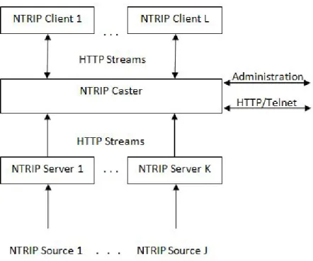
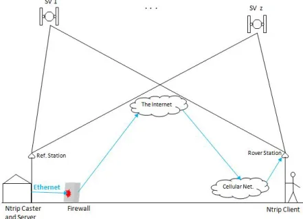
Based on this, NTRIP implementation could been refer to as "NTRIP System". Therefore, in most cases in this work, the term is mostly used. Figure 2.1 illustrates the inter-relationship of the component systems of an NTRIP system.
In Figure 2.1, the Satellites in the space transmit GNSS positioning messages to both the GNSS permanent Reference station and the users with GNSS Rover equipment. The Reference sta-tion acts as the NTRIP Source and NTRIP Server, or as the NTRIP Source only, depending on the Reference station GNSS equipment manufacturer's support and the design of the network operation. Where it acts as NTRIP Source only, it requires an NTRIP Server running on a Personal Computer (PC), configured and connected to the Reference station receiver via serial or Uni-versal Serial Bus (USB) connection. Only if you want to have a local server. Whichever way, the Reference station NTRIP Server can be configured to send real time GNSS correction messages for RTK/DGPS through the Internet to a mountpoint in the NTRIP Caster at the control centre which corresponds to the mountpoint at the Reference station NTRIP Server.
On request, the NTRIP Client at the User's Rover GNSS receiver station connects through the mountpoint and receives real time corrections from the NTRIP Caster through the Internet. The NTRIP Caster is the NTRIP component that receives GNSS correction data from the Reference receivers and distributes it to Rover GNSS receiver users, in real time. This is aimed at im-proving the accuracy of their RTK and DGPS observations in real time. This Internet connection is established either via Bluetooth from a smart phone or through a serial connection to the Rover GNSS receiver from a PC that is Internet enabled, and running NTRIP Client. These data exchange between the Reference station NTRIP Server, Rover GNSS station's NTRIP Client and the Control Centre's NTRIP Caster make use of the popular Client-Server mode of communica-tion approach, where both the NTRIP Server and the NTRIP Client are acting as the Client side (service requesters), while the NTRIP Caster is acting as the Server side (resource or service provider).
The idea of NTRIP GNSS data correction method is based on the assumption that, both the Ref-erence receiver(s) and the Rover GNSS receiver are within the same vicinity and must have suffered similar GNSS errors during observations, and since the reference stations already know their position, therefore, its GNSS correction data are used to improve the positioning of the Rover GNSS receiver relatively. This is done by sending GNSS correction data from nearby ref-erence station(s) to the Rover GNSS receiver in real time via Frequency Modulation (FM) radio or through the Internet using NTRIP. These corrections which are mostly GNSS pseudoranges (distance measurements), positional (ephemeris) data and error models, such as ionosphere, that are simultaneously measured to all satellites in view, and using the known position of the receiver's antenna from each satellite, pseudoranges errors are computed at both the Base and the Rover GNSS stations. These errors are converted to corrections at the Base station and sub-sequently transmitted to Rover GNSS receivers using the NTRIP system at the central processing center as illustrated in Figure 2.2 below.
Figure 2.2: Concept of NTRIP system
2.2
NTRIP Component Systems Overview
NTRIP, which stands for "Networked Transport of RTCM via Internet Protocol" is a protocol de-signed to handle the receiving and distribution of GNSS correction data from the Reference stations to the stationary or mobile GNSS receivers over the Internet, in real time [RTC97]. This is aimed at improving the positioning accuracy of DGPS and RTK applications. As observed in section 2.1, a functional NTRIP services is viewed as a combination of multiple independent component systems brought together via the Internet and satellite signals.
This NTRIP system consists of NTRIP Sources which generates data streams at a specific loca-tion and NTRIP Servers which transfer the data streams from a source to an NTRIP Caster which is the major system component. Finally, NTRIP Clients access data streams of desired NTRIP Sources from the NTRIP Caster [Duv06],[L.L11a]. It is important to note that, when streaming GNSS correction data using NTRIP Client running on a PC, although you may be receiving data streams from many mountpoints, but the NTRIP Client can only output correction data of only one mountpoint of an NTRIP Source to the Rover GNSS receiver. In the same vain, the inbuilt NTRIP Client in the Rover GNSS receiver also allows you to select only one mountpoint at a time. This data streaming component relationship is illustrated in Figure 2.3 below.
Figure 2.3: NTRIP Streaming Systems
Consequently, in order to implement the system, it is essential to examine the operation of each NTRIP component systems.
Therefore, this section presents the underlying technology in each component systems, by ob-serving the mode of operation and how they interact with each other.
2.2.1
TCP/IP, NTRIP and HTTP
The concept of distributing GNSS real time correction data for RTK is addressed in this subsec-tion, by looking at the principle of Internet network and communications which is one of the underlying bases of NTRIP system.
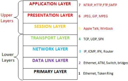
NTRIP, which is an application layer protocol derived from ICECAST Internet Radio technology, happens to be a redesign of Hypertext Transfer Protocol (HTTP) version 1.1 [Geo03b],[Har03a]. The HTTP is an application-level protocol, which is the underlying protocol used by world wide web. It is also used for streaming multi-media contents. HTTP, is a generic, stateless, protocol, which can be used for many tasks beyond its use for hypertext. These include tasks such as, name servers and distributed object management systems. This is made possible through the extension of its request methods, error codes and headers [L.M98].
However, this protocol runs on top of Transmission Control Protocol/Internet Protocol (TCP/IP) layers and is located in the application layer [FW13],[T.C05]. TCP is a protocol designed to provide a connection oriented reliable byte stream on top of the Internet Protocol (IP) [U.B94]. This is to provide reliable data transmission with flow control.
The Open System Interconnection (OSI) model in Figure 2.4, shows the layers which each of these protocols operates [Six12], and they are in a hierarchical order.
Figure 2.4: Open Systems Interconnection (OSI) Model
2.2.2
RTCM and Message Types
RTCM stands for "Radio Technical Commission for Maritime Services", which is an independent international non-profit organization, whose mandate is to develop standards for radio commu-nications and related applications. However, it does not enforce or control the use of these standards by manufacturers, service providers and users [RTC04b].
The RTCM message is an encrypted signal incorporating GNSS information, used to improve the accuracy of DGPS or RTK positioning solutions. They have been several RTCM versions and changes since its development with aim of improving the RTK positioning issues [RTC13a]. These changes as applied to each version is illustrated in Table 2.1.
Table 2.1: RTCM Trend
RTCM version
The year of
application Changes applied
RTCM 1.0 1985 Temporary recommendation for DGPS (PRC and RRC)
RTCM 2.0 1990 DGPS corrections and additional information Messages 1-17, 59 RTCM 2.1 1994 Extension for RTK Messages- 18/19 and 20/21
RTCM 2.2 1998 Extension for DGLONASS Messages 31-37 RTCM 2.3 2001 Additional information for RTK Messages 23,24 RTCM 3.0 2004 New solution for RTK
RTCM 3.1 2006 Solution for transformation
Each of these versions were made to address specific issues, in order to improve the real time GNSS data distribution [RTC90],[RKB11] and also the accuracy of positioning solutions in real time.
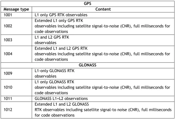
There are also various RTCM message types in these evolving versions, and each is meant to improve GNSS data streaming from either a single source or central source to the Rover GNSS users. These messages primarily comprise of compressed observation data from a GNSS CORS network which are transmitted to the Rover GNSS receiver through the Internet to improve its position correctness [RTC06], [Den13]. The current RTCM version is version 3.x, which was design to overcome the limitations of RTCM version 2.x, however, they are not compatible. Table 2.2 presents RTCM version 3.0 message types and their accompany content.
Table 2.2: RTCM v3.0 Message Types (GPS and GLONASS Observations)
GPS
Message type Content
1001 L1 only GPS RTK observables
1002
Extended L1 only GPS RTK
observables including satellite signal-to-noise (CNR), full milliseconds for code observations
1003 L1 and L2 GPS RTK observables
1004
Extended L1 and L2 GPS RTK
observables including satellite signal-to-noise (CNR), full milliseconds for code observations GLONASS 1009 L1-only GLONASS RTK observables 1010 L1 only GLONASS RTK
observables including satellite signal-to-noise (CNR), full milliseconds for code observations
1011 GLONASS L1+L2 observations
1012
Extended L1 and L2 GLONASS
RTK observables including satellite signal-to noise (CNR), full milliseconds for code observations
Furthermore, RTCM SC104 Standard Version 3.1 introduced the use of the network-RTK technique in place of single-base RTK which increases not only inter receiver distance but also reliability. Although, RTCM network-RTK improved broadcast solution, the required bandwidth for the RTCM network messages need to be considered.
In order to achieve comparable performance, the RTCM network solution generally requires a 1Hz update rate for the master and network correction, which actually require less bandwidth. Also the geometric corrections can be transmitted at a lower update rate. As a result, use of GPRS is desirable over GSM, due to limitation on Baud Rate [YHR09], which makes it more viable in distributing GNSS correction data through the Internet. These message types of version 3.1 and their contents are shown in Table 2.3 below.
Table 2.3: Network messages (RTCM v3.1)
Message type Content
1014 Network Auxiliary Station Data coordinate difference between one auxiliary station and the master station
1015 GPS Ionospheric Correction Differences for all satellites between the master station and one auxiliary station
1016 GPS Geometric Correction Differences for all satellites between the master station and one auxiliary station
1017 GPS Combined Geometric and Ionospheric Correction Differences for all satellites between the master station and one auxiliary station
1018 Reserved for alternative Ionospheric Correction Difference Message 1019 GPS ephemeris
1020 GLONASS ephemeris
2.2.3
NTRIP Caster
The NTRIP Caster is one of the major components in the implementation of NTRIP system. It is the component that is deployed at the control centre, which receives GNSS correction data from various NTRIP Sources through NTRIP Servers, and disseminates them via the Internet to Rover GNSS users on request by an NTRIP Client.
In principle, the NTRIP system consist of NTRIP Caster, NTRIP Server, NTRIP Source and NTRIP Client, but practically both the NTRIP Server, NTRIP Source and NTRIP Client function as a TCP/IP clients on the GNSS Reference station side and the Rover GNSS receiver side respectively [Sys05],[Lei06]. Whereas the NTRIP Caster functions as a TCP/IP server, acting as a device that listens for connections and forward data from several NTRIP Servers to many NTRIP Clients [Den06].
The Servers initiate a connection to the NTRIP Caster asking to upload data from a certain stream through a mountpoint. In the same vain, the Clients initiate a connection to the NTRIP Caster asking for data from a certain stream through a chosen mountpoint. The Caster maintains a Source description parameters called Sourcetable. The Sourcetable contains vital informa-tion about all the Streams, Networks and Casters mountpoints maintained by the NTRIP Caster [Wik12],[Lei05]. In addition, access to the NTRIP Caster is made possible through the IP address, port number, username and password authentications.
2.2.4
NTRIP Source
Basically, the NTRIP Source is the GNSS Reference station that is generating the RTCM message corrections for real time kinematic. Every single NTRIP Source needs a unique mountpoint on an NTRIP Caster which is maintained by the administrator operating the NTRIP services. Currently, most GNSS manufactures have integrated NTRIP functionalities in their equipment which enhances the implementation process [Tri11].
2.2.5
NTRIP Server
NTRIP Server is the component part of the NTRIP system that is responsible for transferring GNSS data corrections of an NTRIP Source to the NTRIP Caster, using the TCP/IP connection proto-col. It is basically, a computer program running on a PC that streams corrections data from the
NTRIP Source to the NTRIP Caster. However, as earlier on observed, most GNSS manufactures are currently integrating it into the NTRIP Source GNSS equipment.
During the setup, the administrator of the NTRIP Caster has to define and made available the IP address of the Caster, the listening port number, the Caster encode password, the username and mountpoints, for the various administrators of the participating NTRIP Servers [Tri11].
2.2.6
NTRIP Client
NTRIP Client is the NTRIP system component that is deployed at the Rover GNSS receiver side. It is responsible for sending a request message to the NTRIP Caster and receiving GNSS data corrections from it via the Internet, for real time correction purposes.
This is possible only if the NTRIP Client sends a correct request message. The correct request message consists of correct NTRIP Caster's IP, listening port, username and password for authen-tication purposes. In response, the Caster sends the updated Sourcetable text file to the NTRIP Client. This contains list of Streams, Networks and Casters mountpoints and their descriptions, which is maintained by the NTRIP Caster. Subsequently, it transmits corrections data to the Client when connection has been established through a chosen mountpoint.
2.3
Implementation Scenario
Implementation scenario refers to the mode of deployment of the NTRIP system, for the dis-semination of GNSS data corrections through the Internet, for RTK purposes. The location of the NTRIP Caster and the way data from the NTRIP Sources interact with the Caster are the fundamental factors in determining the implementation scenario being adopted. They are sev-eral implementation scenarios in the deployment of NTRIP system [L.L11b]. The two prominent situations identified are namely: Centralised and Decentralised mode of implementations.
2.3.1
Centralised NTRIP Caster Approach
The centralised NTRIP Caster approach refers to a situation where the Caster and the Server are at separate locations. This is the fundamental principle of Network RTK, therefore, are usually applied in a network of GNSS CORS. In this case, the reference stations which are the GNSS correction data generators ( i.e. NTRIP Source and the NTRIP Server are integrated together in the GNSS equipment or connected through serial connection) are in a remote locations. The NTRIP Servers encapsulates the GNSS correction data into TCP/IP packets and send them via the Internet to a centralised unit, which may be refer to as a Central Processing Facility (CPF) -NTRIP Caster, which is managed by the Administrator in another location. Probably in the data centre office.
The NTRIP Caster, which acts as a Server, in turn, distributes these GNSS RTK corrections data to NTRIP Clients on request after passing the authentication processes.
Figure 2.5: Centralised NTRIP Caster Approach
2.3.2
Decentralised NTRIP Caster Approach
The decentralised NTRIP Caster approach refers to a situation where the Caster and the Server are the same device, and is deployed to render NTRIP services independently, in a single or network stations. Where this approach is adopted in a network, each reference station acts as an independent node of the network. The Rover GNSS receives information from surrounding reference GNSS stations and decides which mountpoint to use.
However, the decentralised NTRIP Caster approach is often utilized in a situation where you only have one reference GNSS receiver station for the implementation of the NTRIP services. In this case, the reference GNSS receiver which is the data streaming generator is basically installed at a desired location.
It is then connected to a computer running the NTRIP Caster through a serial port or USB connec-tion, where the GNSS equipment does not support NTRIP Caster. On request to the Caster, the NTRIP Client at the Rover GNSS receiver side receives real time GNSS corrections data through the Internet. This scenario is illustrated in Figure 2.6 below.
Figure 2.6: Decentralised NTRIP Caster Approach
2.4
GNSS and GNSS Errors
The implementation of NTRIP services will not be complete and functional without the position-ing systems and the GNSS reference station(s) which are the NTRIP Sources. This section briefly presents the fundamental concept of GNSS in determining position, the GNSS errors and NIGNET Network. This is aimed at highlighting the GNSS positioning errors that need to be corrected at the Rover GNSS receiver side (i.e NTRIP Client) by the transmitted correction messages from the NTRIP Caster, for a better positioning accuracy. In addition, to examine the current status of NIGNET Network.
2.4.1
GNSS
The term GNSS refers to Global Navigation Satellite System, which is a generic name for all space positioning satellite techniques with worldwide coverage [BJ96],[And01]. Currently, GNSS in-clude two fully operational global systems, namely the US, Global Positioning System (GPS) and the Russian Federation’s GLObal NAvigation Satellite System (GLONASS). In addition, there are several GNSS implementation projects, aimed at developing global and regional systems, namely Europe’s European Satellite Navigation System (GALILEO), China’s COMPASS/BeiDou, India’s Re-gional Navigation Satellite System (IRNSS) and so on.
GNSS includes constellations of Earth-orbiting satellites that broadcast their locations in space and time, and of GNSS receivers that calculate ground positions by trilateration method[HWBE08], [HWW03], as illustrate in Figure 2.7. The GNSS receiver at an unknown location uses trilater-ation method to determine its position on the surface of the earth by timing signals from a minimum of four satellites in the space. Its space segment, which is a network of space vehicles (SV's) that orbit the earth, and send a signal to GNSS receivers, provides precise details of the receiver's location, the time of day and the speed the device is moving in relation to the four satellites. Each SV in the GNSS constellation sends out periodic signals along with a time signal.
Figure 2.7: Concept of GNSS Positioning by Trilateration
These are received by GNSS devices which then calculate the distance between the device and each satellite based on the delay between the time the signal was sent and the time when it was received. Once a GNSS device has distances for at least four satellites it can perform the trilateration calculations, and therefore determine its location.
2.4.2
GNSS Errors
The idea behind the transmission of GNSS correction data using the NTRIP for RTK positioning is based on the fact that, all GNSS receivers in the same vicinity would simultaneously experience common errors. In this case, since the GNSS reference station knows its solution, therefore, can calculate the errors in the observation, which is then transmitted in the form of RTCM encrypted messages as corrections to the Rover GNSS receiver station in real time, to improve it's positioning accuracy [GP02],[JL98].
The following factors are responsible for the GNSS positioning errors [EC06] during observations: 1. Satellite and Receiver Clock Errors: This refer to the slight discrepancies in the satellite's atomic clocks and the GNSS receiver clock, which may cause slight position errors in the GNSS receiver. However, this errors are monitored and corrected by the Master Control Station.
2. Satellite Orbit Errors : This concerns the variations of the altitude, position and speed of the satellite, which is as a result of the gravitational pull and solar pressure fluctuations. Orbit errors are equally monitored and corrected by the Master Control Station.
3. Atmospheric Interference : This refers to the Ionospheric and Tropospheric errors which tends to slow or speed up the signal from the satellite, therefore, introducing errors on the receiving signal by the GNSS receiver.
4. Multipath : This refers to the error introduce by reflected signals from surfaces near the receiver, that can either interfere with or be mistaken for the signal that follows the
straight line path from the satellite. This type of error is difficult to detect and sometime hard to avoid, although with the use of choke ring antenna, this error can be mitigated. However, the error due to multipath cannot be corrected by the DGPS and RTK corrections.
2.5
NIGNET Network
NIGNET refers to Nigerian Permanent GNSS Network. It evolves in pursuant of the African Geode-tic Reference Frame (AFREF) project by Nigerian Government through OSGoF [Won12],[RH11] and [AFR15]. NIGNET is a network of Continuously Operating Reference Stations (CORS), con-sists of state of the art GNSS equipment as at 2015 [BJG10]. These CORS are geometrically distributed within the country and constitute what could be termed permanent GNSS reference stations ( see Figure 1.1).
All the remote GNSS reference stations within the network are configured to stream their GNSS data to a cloud based data storage, through File Transfer Protocol (FTP) push over the popular TCP/IP protocols. This is made possible by providing Internet support via Virtual Private Network (VPN) to the remote stations, with an exception of one station (GEMB) that makes use of Very Small Aperture Terminal (VSAT). The data from the cloud based storage are them transmitted to the OSGoF control centre as a backup.
In addition, a web interface was made available, which gives users access to the GNSS data in hatanaka format, which is a special compression format developed for rinex files [UNA15]. Furthermore, the web interface offers a remote monitoring capability of all the stations within the network by an administrator. This is very vital, in order to ensure that the stations status are operating properly and to report any malfunctioning to the appropriate quarter for further action. This is done by the integration of MGN-NIGNET v1.2 lite software in the network, which is a GNSS remote monitoring suit [P.M12] that enhances remote access to the stations.
Figure 2.8 below, describes the NIGNET data dissemination architecture.
2.6
Summary
The concept of NTRIP, GNSS, GNSS errors and NIGNET Network have been examined and pre-sented in this chapter. These were addressed by investigating the inter-relationship of NTRIP component systems, system overview and the implementation scenarios of NTRIP system. Fur-thermore, the fundamental principles of GNSS positioning was highlighted and some of the fac-tors that causes errors in the GNSS observations. This is to ensure basic theoretical knowledge of each system for successful implementation of the research work. In addition, the current sta-tus, geographical locations, monitoring mechanism and data streaming architecture of NIGNET Network were presented.
These fundamental knowledge of all the various components that make up a functional NTRIP system, highlighted in this chapter, obviously reveals the possibility to use NTRIP system in NIGNET Network, for the distribution of GNSS data corrections to various RTK users in real time via the Internet.
Chapter 3
State of the Art
3.1
Introduction
This chapter presents several contemporary research works being carried out, in order to reveal the state of the art of Networked Transport of RTCM via Internet Protocol (NTRIP) and Nigerian Permanent GNSS Network (NIGNET). The evolution, trends and various applications of NTRIP protocol, as well as current status of NIGNET are examined in this chapter. This is to gain more knowledge about the application. In addition, it would guide in the choice of hardware and software applications, for proper implementation of the project.
3.2
NTRIP Evolution
The evolution of NTRIP system, and its deployment for the dissemination of Global Positioning System / Global Navigation Satellite System (GPS/GNSS) data, for real-time corrections and cur-rent improvements, are presented in this section. This is aimed at revealing the origin of the NTRIP protocol.
The evolution of NTRIP protocol was attributed to the result of a feasibility study on real-time streaming of differential GPS corrections, as described in [GK02]. The paper reveals that, the NTRIP project was initiated by the German Federal Agency for Cartography and Geodesy (Bunde-samt für Kartographie und Geodäsie, BKG). The work also observes that, because dissemination of RTCM SC-104 messages is the principal application, therefore, the whole system presents a transport protocol that is referred to as NTRIP Protocol.
The underlying application-level protocol for the design of NTRIP was observed to be developed and standardized by Radio Technical Commission for Maritime Services (RTCM) [RTC90],[RTC92], which is an international standard organisation with several Special Committees. Each commit-tee is responsible for providing standard for a particular navigational problem. The Special Committee (SC) 104, for instance, is charged with the responsibility of providing standards for DGPS and RTK applications.
RTCM consist of over 130 member organizations and fifteen Special Committees as of 2014, each having a special task to accomplish [RTC14b]. The Special Committee-SC-104 on Differen-tial Global Navigation Satellite Systems (DGNSS) is charged with the responsibilities of providing standards that are used in Differential GPS and Real Time Kinematic operations [Wik14], [RTC01]. This is to enable the transmission of GNSS data correction in real time through the Internet. The RTCM message is an encrypted signal incorporating GNSS information used to improve the ac-curacy of DGPS or RTK position solutions. They have been several RTCM versions and changes since its development with aim of improving the RTK positioning.
There have been several versions of RTCM since its inception, each aimed at standardizing and/or improving the NTRIP protocol performance. These were presented in [RTC13a], and the descrip-tions of the standard and additional supports of each developed versions. The current RTCM was observed to be RTCM 1040-3.2 and Differential GNSS Services - Version 3.1. These papers [RTC13a],[RTC13b] and [RTC14a] agreed unanimously that, it is more efficient alternative to RTCM version 2.3.
In [RTC97], the documents that describes system design and protocol details are presented. It aimed at defining a standard for a HTTP based protocol, for the dissemination of Differential Global Navigation Satellite System (DGNSS) data (or other kinds of GNSS streaming data) to sta-tionary or mobile receivers over the Internet. In addition, It also report on some implementation examples, therefore contributing to software availability.
The "Usefulness of Internet-based NTRIP Real Time Kinematic (RTK) for navigation and intelligent transportation systems" was investigated in [Mar01]. The research work focuses on evaluating the performance of NTRIP/RTK solutions for accurate and precise car navigation. The approach was based on field experiments, and the analysis of both the accuracy and availability of RTK data using mobile wireless transmissions prove to be satisfactory. The paper also investigates the advantages and disadvantages of each component in the navigation system, by deploying car experiments on test routes under different driving conditions, which also reveals a better positioning solutions using NTRIP.
Test results from the NovAtel RT2 real-time-kinematic carrier phase positioning program was presented in [JBNM96]. The research presents test results from the new RT2 real-time carrier phase positioning system developed by NovAtel. The work tries to expand the single frequency carrier phase positioning technology introduced in 1994 as RT20, by taking advantage of the dual frequency capability recently introduced in GNSS equipment. The result shows typical integer resolution times of about 1 minute on short baselines and typical low latency horizontal position accuracies of 1 to 3 cm, with a direct RS232 data link, Baud Rate of 1200 to 2400 (about twice the message bit rate).
NTRIP, as an application-level protocol for streaming GNSS data over the Internet was examined in [Geo03a],[Har03a] and [Har03b]. They papers reveal that, it is a generic, stateless protocol based on the Hypertext Transfer Protocol HTTP/1.1., whose HTTP objects are enhanced to real time GNSS data streaming.
The completion and release of a new standard, designated as version 1.0 and titled “Networked Transport of RTCM via Internet Protocol" (NTRIP), by RTCM Special Committee 104 in 2004, was discussed in [RTC04a],[RTC04b]. The papers reveal that, this new standard was named for the widely used RTCM data format, and defines a protocol for streaming differential correction data or other kinds of GNSS data for RTK corrections to stationary or mobile GNSS users over the In-ternet.
The theoretical and technical basics of NTRIP was addressed in [Len04],[Duv06] and the survey controller software from Trimble Navigation Ltd was used to illustrate the practical application of the NTRIP technique. The papers reveal that, NTRIP protocol is capable of providing the most
tions. In their separate investigations and conclusions, the research works mutually agreed that the NTRIP is a technique for now and in the future, in terms of GNSS correction data streaming and distribution.
The EUREF-IP pilot project presents "NTRIP Example Implementation", which consist of a detailed documentation of NTRIP system [Den06]. The paper outlines the architecture and the techniques involved in the successful implementation of NTRIP protocol, in any real time GPS/GNSS data dissemination network. Furthermore, It itemises the developed programs and operating system each programs are compatible with.
In [GWG06], the descriptions of the http-based technique for streaming GNSS data to mobile users, such as RTK and DGPS applications in the construction and mining work, that are nected to the Internet via Mobile IP-Networks like GSM, GPRS was presented. The paper con-cludes that , NTRIP technique remains GNSS data streaming protocol for now and also in the future.
3.3
NTRIP Applications and CORS GNSS
Analysis of networked transport of RTCM via Internet protocol and real-time IGS (RT-IGS) was carried out in [Tho11].The work investigates, various design aspects of both protocols from the computer network perspective, covering factors such as data latency, integrity, firewall or proxy server compatibility and scalability. The paper observes that, the differences in these charac-teristics between the two protocols come from their selection of the transport layer protocol. It reveals that, NTRIP uses TCP while RT-IGS uses UDP. The work further reveals that, version 1.0 of NTRIP is currently the most widely-used protocol for distributing real-time GNSS data over the Internet. In addition, data latency and integrity using NTRIP over the Internet were examined, in order to identify their impacts on user's applications in terms of quality of real-time kinematic positioning. The test data obtained from the SydNET GNSS reference station network in Syd-ney, Australia, were evaluated using both wired and wireless data networks. The research work concludes that, the performance of the real-time GNSS data distribution system satisfy the re-quirement of the end-user applications. The observed latency was less than two seconds during most of the test period and within this range, there was little variation in the positioning quality. Various GNSS data protocols such as Transmission Control Protocol (TCP), File Transfer Protocol (FTP) and NTRIP, used for dissemination of Continuously Operating Reference Station (CORS) data was reviewed in [IGN06]. The paper re-evaluates several choices available to both CORS network operators and end users, by presenting a comprehensive analysis of the similarities and differences between these methods. Furthermore, the advantages and disadvantages of each of the GNSS data distribution methods were described, with respect to their implementation in Australian setting. The research work concludes by observing that, changes in how CORS net-work operates have resulted in new GNSS data transfer protocols, which evidently changed the way GNSS data are accessed and applied in our day to day GNSS applications.
The NTRIP system was observed to be technique for now and for the future, as opined by [GWG06]. This was evident in [MY08], which pointed out the drawbacks in other methods of position fixing that has to do with long baseline. It was observed that, for differential correction
data, it is important to be streaming from a nearby source. According to the paper, the best results was obtained when the source is less than 40-50km.
Performance test exercise in TrigNet was presented in [C.M07]. The paper discussed the NTRIP resources available in TrigNet, which is a network of active GPS/GNSS base stations in South Africa. It highlights the strengths and weaknesses of the system. The research work analyses and presents various accuracies achievable, with respect to the distance from a base station. It pointed out that, for RTK, accuracy use to decrease with distance in the following manner: 3cm at 2km, 8cm at 113km, and 18cm at 1,315km. It further observed that, no difficulty was expe-rienced in resolving integers at a range of 113km, although only a floating point solution could be obtained at the 1315km range. In addition, the work suggests that, for any functional NTRIP system to guarantee reliability, there should be data integrity monitoring from the provider, and good internet network for both the client and the server sides.
Investigation of RTK and Real-Time DGPS corrected observations based on NTRIP protocol was carried out by [Thi08]. The work deployed three different GPS receivers; high, medium and low accurate GPS, which was classified according to the receiver accuracy performance and cost. The research work observes that, NTRIP is a cost effective, secure and reliable alternative to replace traditionally accepted methods of RTK and real-time DGPS correction streaming tech-niques such as the use of Very High Frequency (VHF) radio signal and Wide Area Augmentation Systems (WAAS) for transmission of GNSS correction data.
NTRIP corrections via CORS network for TeeJet Technologies RX-600RTK was researched in [Tee08]. The paper describes, the steps that can be taken to evaluate whether or not NTRIP type RTK corrections delivered via cellular modem from a CORS network are available in any given US location. However, the paper observed that, due to the inherent in-accurate nature of defining cellular coverage areas, the results obtained following this evaluation should be considered in-dicative, therefore, does not constitute a guarantee of successful operation of the system. The work further pointed out that, accessing NTRIP data via cell modem is possible almost anywhere you have cell phone coverage, but better RTK level accuracy will only be achieved if the unit is within the network being referenced.
The European position determination system technical standards was presented in [EUP08], which is a standard for the implementation of NTRIP services. The work extensively outlines the general guidelines necessary for NTRIP implementation in EUPOS. The paper concludes by stating that, the "EUPOS Steering Committee decides that the EUPOS Technical Standards are to be used by all members and partners of EUPOS as obligatory EUPOS standards". In addition, the paper made it clear that, changes of the standard definitions need an EUPOS Steering Commit-tee resolution.
The "International standard GNSS real-time data formats and protocols" were examined by [YHR09]. It describes the mechanisms for real-time delivery of GNSS data in terms of trans-mission protocol, data format, communication link issues, message structure and data types. In addition, content between the various versions of RTCM SC-104 formats, including recent amendments were addressed. RTCM SC-104 is the Special Committee charged with the respon-sibilities of defining protocol for the streaming and distribution of GNSS correction data in real