BULLETIN OF THE SERBIAN GEOGRAPHICAL SOCIETY
2009.
LXXXIX -
. 4
YEAR 2009
TOME LXXXIX - N 4
UDC 911.2:551.7(497.11) Ц ∗ -: -ђ ђ .
ђ ђ ( )
( ).
: - , , , ,
, .
ђ Ц .
75 100 m.
ђ 100 135 m.
- , , Ц
- .
800 km2
80 km . ,
,
( , ., 1989).
( , ., 1984) ( 1). , ., , ., (2002),
. , ђ
. , ,
. ђ
- .
.
( , ., 1999).
∗
, , – , 3/3, .
Ј , , – ,
3/3, .
146005
.
,
.
1.
. ђ
.
?
BZ-2 306-1335 m,
( 2).
.
.
160 m ( , 1980) .
1981. ђ
(DB-1 )
ђ o ( , .,
Ц Ш .
2.
.
.
ђ .
,
.
.
( , .,
, ., 2005).
DB-1 207,5 m
( ).
- IEDB-1 o
( ) 216-300 m, 300-330 m
o .
( ) ,
( , . ., 1990).
-1, ,
412-470 m ђ o
, -1
ђ -2
610 m. , ,
. К . ( -1) 500-630 m .
Z-1 295 m
. , . , . , , .
BZ-2 287 m.
ђ K/Ar 35 .
. , , ,
.
, ђ .
, D-1 DB-1
170-200 m. , -1
- - 412 m.
, , -1
207-310 m, , -1
ђ 105-495 m.
. 200 m. К . .
ђ (
3.
:
(1- ; 2- ; 3- ; 4- ;
5-; 6- ; 7- ;
8-;
9-; 10- ; 11- ; 12- ;
( , ., ., 1996-97) ( 4).
. ђ ,
, .
, ,
( , ., 2005).
4. Ј
:
( - ; - - ; -
-; - ; Ј - Ј ;
-- ; - ; -
( ). ,
,
(Robertson, A., ., 2008; , ., ., 1995).
.
, ., ., (2002),
.
. ,
,
,
.
.
, ( , .,
, ., 1985).
( , ., 1989).
25-26 km, 17 km.
.
,
Ц ( , ., , ., 1979-1980).
ђ
( 5).
6.
-. , , . . - . ђ , . ,
- ( , ., Ђ , ., 1989).
.
.
.
, ђ
. ђ . ( ) ( ) . . . . ђ ђ ( ) ( ) . ђ - , . - .
(1980). Ш . : .
, . (1989). Ш . Г С
, LXIV, (2), 9-15.
, . (1999). , Ш . Г
С , LXXXIX, 15-20.
, ., , . (2002). , Ш . :
-.
, . (1984). . Г С
Karamata, S., Krstić, B., Dimitrijević, M. N., Knežević, V., Stojanov, R., Filipović, I. (1996-97). Terranes Between the Moesian Plate and the Adriatic Sea. Annales Geologiques des Pays Helleniques, 37, 429-477.
, ., , . (1985). Ш . Г
Б , 49, 221-246.
, ., Ђ , . (1989). ,
-. Г Б , 53, 190-196.
Marović, M., Djoković, I., Pešić, L., Toljić, M., Gerzina, N. (2002). Neotectonics and Seismicity of the Southern Margin of the Pannonian Basin. Special publication series, 3, 277-295, “European Geosciences Union.”
Martinović, M., Milivojević, M. (2005). The Possibilities for Electric Energy Production from Geothermal Energy in Serbia. “World Geothermal Congress” Antalya, Turkey, 24-29 April, 2005.
, ., , ., , ., , (1990). И ј њ
њ . : -
-, .
Milivojević, M., Martinović, M. (2000). Geothermal EnergyPossibilities, Exploration and Future Prospects in Serbia. “World Geothermal Congress”Kyushu - Tohoku, Japan, May 28 - June 10, 2000.
Milovanović, D., Marchig, V., Karamata, S. (1995). Petrology of the Crossite Schist from Fruška Gora Mountain (Yugoslavia), Relic of a Subducted Slab of the Tethyan Oceanic Crust, Geodynamics, 20 (3), 289-304.
, ., , . (1979-1980).
. Г Б , 43/44, 531-550.
Robertson A., Karamata, S., Šarić, K. (2008). Overview of ophiolites and related units in the Late Paleozoic-Early Cenozoic magmatic and tectonic development of Tethys in the northern part of the Balkan region. Lithos
(article in press).
, . (1989). Г њ . : -
-.
UDC 911.2:551.7(497.11)
IVANACAREVIĆ∗ VELIMIR JOVANOVIĆ
STRATIGRAPHIC-STRUCTURAL CHARACTERISTICS OF MAČVA BASIN
Abstract: The analysis of stratigraphic-structural features of Mačva basin had been conducted in this paper on the basis of data obtained with deep exploratory boring performed for the needs of hydrogeothermal research project for the purpose of identifying the reserves of geothermal energy of Mačva. The research has been carried out with the aim of finding out the relation between the Tertiary and its Triassic bedrock (Ladinian and Carnian stages) in which process the considerable realistic image of paleorelief (the bedrock of Tertiary deposits) was obtained.
Key words: stratigraphical-tectonic features, paleorelief, Mačva basin, exploratory boring, Tertiary, Triassic.
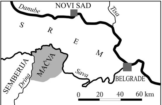
Geographical and geomorphological characteristics
Mačva belongs to southern margin of Pannonian basin located between the Cer and Fruška Gora Mountains. It is mostly the plain belt (75-100 m height above sea-level). Smaller part of the area in the south is of slightly agitated hills (100-135 m height above sea-level).
The terrain is northward and north-eastward marked with Srem, westward with Semberija, southward with Cer Mountain and Pocerina in south-east.
Mačva represents the agriculture region of about 800 km2 located 80 km west from Belgrade. Morphologically, the studied area is related to plain or lowlands belt of Mačva where Drina and Sava Rivers are dominated (Grčić, M., 1989). Dynamic evolution of these rivers with its tributaries gave the basic morphological and hydrogeological features with spacious terrace planes of modern relief (Zeremski, M., 1984) (Fig. 1).
According to (Grčić, M., Grčić, Lj., 2002), Mačva is well individualized geomorphological entity. It is a fan-shaped alluvial plane between the Sava River arc and Lower Drina River. It represents the structural, and/or accumulative and macro flood plane of Drina River. Recent erosion and modern watersheds development transformed Mačva into the erosive river-denudation plane. The Lowest Mačva is of spacious alluvial planes of the rivers of Sava and Drina and its right tributaries. Those are the swampy and flooded terrains being overflowed during the each inundation with river’s meandering development (Grčić, M., 1999).
During the geological time Drina River has changed its flow in Mačva lowlands from east to west and formed the spacious terrace plane. Sava River flow has a direct influence in draining and inundation of alluvial plane and fuelling of minor flows and aquifers that are below river level during the maximum water level.
∗M.S. Ivana Carević, assistant lecturer, University of Belgrade–Faculty of Geography, Studentski Trg 3/3, Belgrade.
Ph.D. Velimir Jovanović, full-time professor, University of Belgrade–Faculty of Geography, Studentski Trg 3/3, Belgrade.
Figure 1. Location of the studied area
Geological framework
The area of the Mačva basin belongs to the southern part of Pannonian basin. From a geological point of view it represents the spacious depression filled with Neogene and Quaternary deposits, that is why the geological setting can be represented only within the data obtained with shallow and deep exploratory boring and hydrogeological exploratory boring.
Paleozoic ?
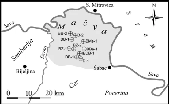
The oldest deposits are represented by meta sandstones and meta siltstones bored in a drill hole BZ-2 at depths from 306 m to 1335 m for which it is considered the Paleozoic age (Fig. 2). They originated by thermo-metamorphism of sandstones and siltstones due to the very strong geothermal activity caused by granitoid magma intrusion during Neogene. Their composition and setting suggest the flysch series formed in the environment of turbidite character.
Mesozoic
The area of Mačva basin is covered by alluvial sediments of Drina and Sava Rivers with maximum depth up to 160 m (Group of authors, 1980) underlain the Neogene deposits. The paleorelief of Neogene sediments in Mačva was discovered only in 1981, when the first geothermal well was drilled (DB-1 Dublje) that cored the bedrock of Neogene sediments. At the well site, the paleorelief is composed of karstified Middle Triassic limestones (Milivojević, M., Martinović, M., 2000).
Figure 2. Location of drilling holes in Mačva basin
Sediments of Mesozoic age are determined with exploratory boring in a number of localities. They are represented with deposits of Ladinian and Carnian stages considered as one sedimentary complex in this work. These are Triassic carbonate deposits made of limestones and dolomites.
The latest geological and hydrogeological investigations determined the Triassic carbonate sediments in drill holes in localities of the villages of Dublje, Bogatić and Belotić, considering the fact of wider distribution of Triassic sediments in Mačva area. It must be mentioned the great geothermal potentiality of these rocks in this area (Martinović, M., Milivojević, M., 2005).
In Dublje borehole DB-1 Neogene bedrock is at depth of 207,5 m and is represented by karstified limestones of Middle Triassic age (Ladinian stage). In exploratory well IEDB-1 karstified Late Triassic limestones of Carnian stage are cored in interval from 2IEDB-16 m to 300 m, while the cored interval 300-330 m consisted of Middle Triassic limestones. These massive and bedded dark grey limestones (biosparites) contain the relatively rich association of microflora, microfauna and fragments of recrystalized echinodermates (Milivojević, M., et al 1990).
In the northern periphery of Bogatić, in drill hole BB-1 at Bair, in the depth interval from 412 m to 470 m sediments of Late Triassic age are determined and are represented by clayey limestones, while the dolomites of the same age are cored in borehole BBe-1 in Belotić in the depth interval from 310 m to 450 m.
Triassic sediments are determined also in drill hole BB-2 in Bogatić in the depth of 610 m. These are the white, compact limestones of suggested age; it was not possible to determine the relative age of the sediments due to the lack of faunal material.
Cenozoic
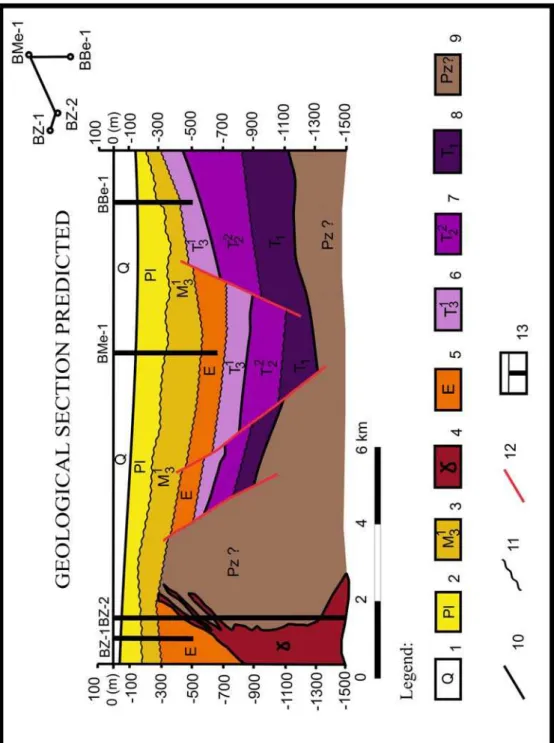
Figure 3. Geological section predicted of the studied area
Legend:
Paleogene
According to the results of exploratory boring the oldest Cenozoic deposits are of Eocene age; in Metković (drill hole BMe-1) in depth interval 500-630 m are drilled poorly consolidated pyrite coarse-grained sandstones and sands of Eocene age.
In borehole BZ-1 in Bogatić at depth interval of 295 m is cored the bedrock of close-grained grey compact sandstones.
The mentioned sandstones are of suggested Eocene age, because there are not paleontological evidences for dating these formations. These sediments are preserved only in highly narrow areas and are unconformably overlain and underlain. Thus it can be concluded that they originated in limited tectonic depressions of extremely reducing conditions due to the pyrite and lack of fossil materials.
Igneous rocks
The acid igneous rocks of granitoid composition are revealed with exploratory boring in drill hole BZ-2 in seven intervals from depth of 287 m. Their relative age is 35 Ma dated by K/Ar method.
Neogene
Caspibrackish sediments of Pannonian age have the great distribution in the studied area. They are represented with gravels, sands, clays, conglomerates and marly sediments. They mostly unconformably overlain Triassic deposits, rarely Eocene deposits.
Next to Dublje in boreholes D-1 and DB-1 they are cored at depth interval from 170 m to 200 m. In the northern periphery of Bogatić, drill hole BB-1 cored the clayey-sandy-gravely deposits up to depth of 412 m. Eastward, in the Belotić locality, drill hole BBe-1 cored the Pannonian deposits in depth interval from 207 m to 310 m, while in Metković, the same formation is determined in depth interval from 105 m to 495 m.
Pliocene formations were formed in the sinking areas deposited with fluvial and terrestrial sediments. This sedimentary series is drilled in a number of localities in Mačva basin with a thickness of about 200 m.
Quaternary
Quaternary formations cover the entire area. The thickness of these deposits in some boreholes is more then one hundred meters.
By virtue of data obtained by hydrogeological exploratory boring, predicted geological profile of the central part of the basin is done (Fig. 3).
Structural-tectonic characteristics
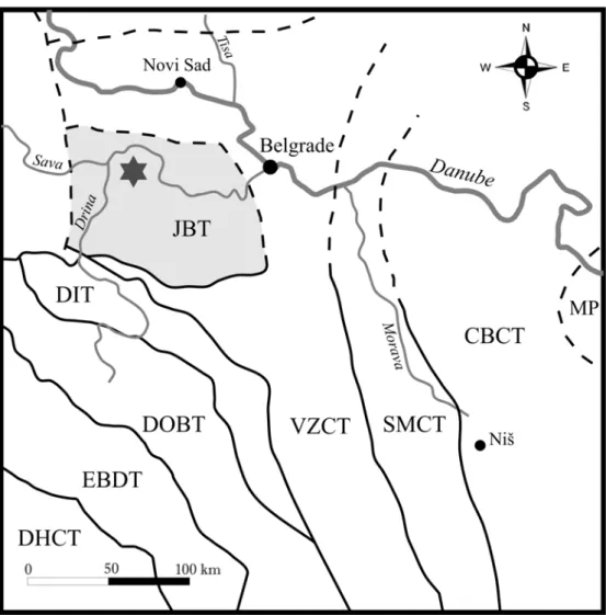
Mačva basin from the aspect of “plate tectonic” theory embrace the further north parts of Jadar block terrane. The docking time of the Jadar block with the Vardar zone took place during the Late Cretaceous (Karamata, S., et al 1996-97) (Fig. 4).
Tectonic structures - deep seated faults and tectonic melanges – are geologically well marked and exposed for direct observation in the southern half of the Jadar tectono-stratigraphic unit. Unlike these, the boundary faults are covered by thick Neogene deposits in the northern half of the unit, as inferred from drilling data. Thus, the drilled Triassic limestone aquifers belong to the Jadar terrane, and the drilled ophiolite, north of the Sava, to the Vardar Zone (Filipović, I., 2005).
Figure 4. Jadar block terrane within the Composite terranes of Serbia Legend:
MP-Moesian plate; CBCT-Composite terrane of Carpatho-Balkanides; SMCT-Serbian-Macedonian composite terrane; VZCT-Vardar zone composite terrane; JBT-Jadar block terrane; DIT-Drina-Ivanjica terrane; DOBT-Dinaric Ophiolite Belt terrane; EBDT-East Bosnian-Durmitor terrane; DHCT-Dalmatian-Herzegovinian composite terrane.
eastern parts of the Vardar ocean was in Late Jurassic, but the western branch was closed in Late Cretaceous (Robertson, A., et al 2008; Milovanović, D., et al 1995).
Paratethys waters. By that time the basic and greater neotectonic structures began to form evolving through the Upper Miocene up-to-date (Marović, M., Knežević, S., 1985).
The Earth crust thickness of the Mačva basin is relatively well known due to the results of geophysical investigations (Stefanović, D., 1989). The lowest thickness is 25-26 km of which the granite layer is 17 km thick. The results obtained by deep exploratory boring suggest the very high rates of terrestrial heat flow. The main cause of such condition is a low Earth’s crust thickness, the presence of thick granite layer and relatively young magmatism in the Cer area (Perić, M., Milivojević, M., 1979-1980).
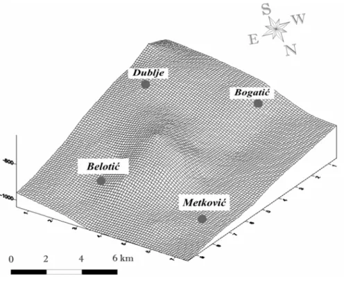
By virtue of paleorelief map of the Triassic in the basin of Mačva, the realistic image of Tertiary sediments bedrock is obtained (Fig. 5).
Paleorelief image points out the uplifted horst like structure in the central part of the studied area that extends in the northwest-southeast direction; it originated, probably, as a consequence of smaller pluton intrusion. It is interestingly to mention that all the boreholes drilled in the areas of Dublje, Bogatić and Belotić are thermo-mineral productive, while the heating of Triassic hydrogeothermal reservoir is induced by intruded granitoide pluton.
On the basis of paleorelief image it is possible to detach two smaller paleo depressions in the localities of Bogatić and Belotić. The southern block of the basin is relatively uplifted and extends east-westward as a consequence of neotectonic activity. The pass areas between uplifted and downthrown blocks are by the rules the most active neotectonic zones and are marked by faults. Namely, for the most part, the Mačva basin is intersected by discontinuities in E-W direction (Marović, M., Djoković, I., 1989). These are regional dislocations analogous to southern margin of Pannonian basin in which formation they took place. Those are probably the older rupture structures being reactivated during the neotectonic phase.
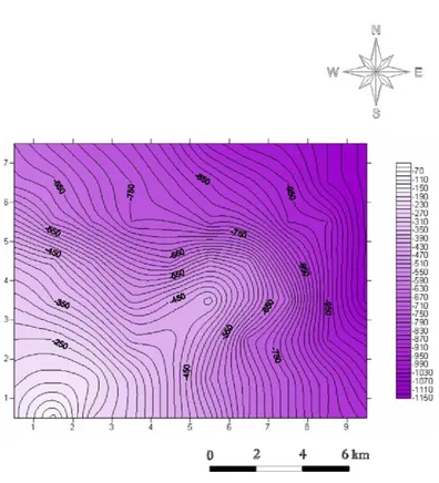
Fifure 6. Map of paleorelief hypsometry of Mačva basin
Conclusion
The area of the Mačva basin belongs to the southern part of Pannonian basin. From a geological point of view it represents the spacious depression filled with Neogene and Quaternary deposits, that is why the geological setting can be represented only within the data obtained with shallow and deep exploratory boring and hydrogeological exploratory boring.
It is determined that the oldest deposits are represented by meta sandstones and meta siltstones of suggested Paleozoic age. They are unconformably overlain by carbonate formations of Middle Triassic (Ladinian stage) and Late Triassic (Carnian stage) that are of great hydrogeothermal potenciality.
Paleogene acid igneous rocks of granitoide composition directly heat the Triassic hydrogeothermal reservoir. Within the Cainozoic formations the suggested Eocene sandstones are described discordantly overlain the older base and Pannonian brackish deposits overlain with lacustrine Pliocene sediments.
The basin of Mačva from the aspect of plate tectonic theory belongs to the further northern part of Jadar block terrane that is being docked to the composite terrane of Vardar zone during the Upper Cretaceous.
The special attention in this paper is dedicated in identifying the relation between the Tertiary formations and its bedrock made of Middle Triassic (Ladinian stage) and Upper Triassic (Carnian stage) carbonate deposits. By the analysis of paleorelief map of Triassic it is determined the uplifted horst structure in the central part of the investigated area with NW-SE strike, formed probably as a consequence of smaller pluton intrusion.
For the most part, the Mačva basin is intersected by discontinuities in E-W direction as older rupture structures being reactivated during the neotectonic stage.
References