ORGANISING COMMITTEE
CIMA – Centro de Investigação Marinha e Ambiental, Universidade do Algarve Tomasz Boski
Delminda Moura Cristina Veiga-Pires, Simon Connor
Centro de Geologia, Faculdade de Ciências, Universidade de Lisboa Maria Conceição Freitas
Universidade de Aveiro Cristina Bernardes
Museo Nacional Ciencias Naturales, Madrid Cari Zazo
Universidad de Salamanca Jose Luis Goy
UNED Javier Lario
Universidad de Alcalá Teresa Bardají
Collaborators:
César Andrade, João Cabral, Ruben Dias, Ricardo Ressurreição, João Alveirinho Dias, Óscar Ferreira, Saritta Camacho da Encarnação, Laura Pereira and Duarte Nuno R. Duarte
Graphical editing:
Carlos Sousa and Ana Gomes
Meeting secretary:
Grupo de Trabalho Português para o Estudo do
Quaternário (GTPEQ)
&
Asociación Española para el Estudio del
Cuaternario (AEQUA)
VII Iberian Quaternary Meeting
“The future of the Iberian environment – lessons from the recent geological past” Faro, Portugal
5th – 9th October 2009
FIELD GUIDE
Editorial board:
Ana Gomes, Tomasz Boski & Delminda Moura CIMA – Centro de Investigação Marinha e Ambiental
Universidade do Algarve ISBN: 978-989-95636-5-0
VII Reunião do Quaternário Ibérico, Faro 2009
29
VII Reunião do Quaternário Ibérico, Faro 2009
30
STOP I
Olhos de Água
D. Moura & T. Boski
1. Regional Geology
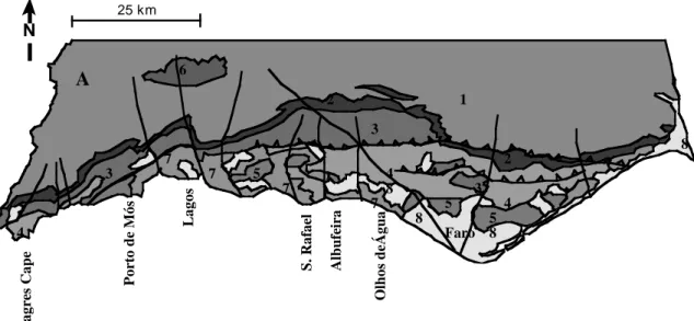
The occurrence of rocky and sandy cliffs on the south coast of the Algarve is a consequence of tectonic movement since the Upper Miocene. The Algarve Basin was affected by uplift west of Olhos de Água and subsidence to the east. This process created local sedimentary basins in the easternmost part of the Algarve which filled with sediment throughout the Pliocene and Pleistocene (Moura & Boski, 1999). In contrast to the carbonate sediments formed on the continental shelf during the Miocene, the Pliocene and Pleistocene sediments are mostly siliclastic, deposited in littoral and continental environments. Rapid uplift and consequent erosion produced abundant clastic sediments, which were carried into the regional sedimentary basins. These processes are reflected in lithological differences between cliffs on the west and east coast of the Algarve (Fig.1).
N
Ca rbon iferou s b aseme nt
Up per Tri assic an d Lo wer Jura ssic (Hetta ng ian ) Lo wer an d Midd le Jura ssic
U ppe r Ju rassic
L owe r C retaceo us
Mon chiq ue Syen ite Mi ocen e
Plio cen e and Qua te rnary
Fau lt Thru st 25 km S agr es C ap e O lh o s d eÁ g u a S . R af ae l A lb u fei ra L agos P or to d e M ós Faro 4 A 1 2 2 3 3 3 4 4 5 5 5 6 7 7 7 7 8 8 8 8
Figure 1. Geological setting of the Algarve region. 1- Carboniferous basement; 2- Lower
Jurassic & Upper Triassic; 3- Lower & Middle Jurassic; 4- Upper Jurassic; 5- Lower Cretaceous; 6- Upper Cretaceous; 7- Miocene; 8- Pliocene and Pleistocene
VII Reunião do Quaternário Ibérico, Faro 2009
31
2. Local Geological setting
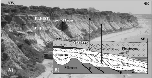
The Olhos de Água site is located right on the border between the Algarve’s windward coastal sector (barlavento algarvio) and the leeward coastal sector (sotavento algarvio). Olhos de Água means “water eyes”, which comes from the freshwater seepage points that occur in the intertidal zone. The shoreline, roughly oriented W-E between Galé and Olhos de Água, changes to NW-SE after this location (Figs. 1 and 2A).
The cliffs at Olhos de Água expose mainly detrital sediments, which preserve a karstic morphology on Miocene calcarenites. The sequence’s thickness increases eastward, infilling sedimentary basins faulted in a demi-graben pattern (Silva, 1988). The geometry of these infills was determined during the Lower Pliocene by the budget between small basins, sea-level rise and a large amount of sediment coming from the hinterland. The basins were rapidly filled with clastic sediments eroded from Cretaceous and Triassic formations, surplus sediment being exported to neighbouring basins. Sedimentary structures point to a south-eastward migration of the sedimentary bodies, inducing shoreline rotation from EW to NW-SE, as we can currently observe (Figs. 1 and 2A).
The most remarkable features of the exposed sequence are fauna-rich carbonate layers within the ca. 40m of siliclastic sediments (Fig. 2A,B, Fig. 3 and Table 1).
VII Reunião do Quaternário Ibérico, Faro 2009
32 Figure 2. General view of the Olhos de Água cliff (A) and a schematic profile showing the
relationships between the sedimentary facies on a NW-SE profile (B)
Figure 3. The Praia do Barranco outcrop showing the vertical distribution of the sediment facies,
the attributes of which are summarized in Table 1.
PLIOC. PLEIST. NW SE Miocene NW SE Lagoonal facies Pliocene Pleistocene A) B) F F F a) b) c) d) e) to h) i)
VII Reunião do Quaternário Ibérico, Faro 2009
33 Table 1. Attributes of sedimentological facies and paleoenvironmental interpretation of the
Barranco outcrop (Fig.3)
Sedimentary facies Fossil content Geopolarity Environment
a) Micaceous yellow sandy silt. Vestigial biotite in the clay fraction.
Inverse Shallow marine
b) Conglomerate with well rounded pebbles of quartzite and greywacke with occasional schist and dolerite pebbles.
? Erosional episode
e) Coarse to very coarse white sand with cross stratification. Fe and Mn oxides. Conglomerate layers.
? Littoral complex
d) Fossiliferous conglomerate with quartzite pebbles and frequent dolerite clasts.
Bones of marine mammals, well preserved teeth of Isurus sp. and
Carcharacles megalodon teeth (adult
specimens), showing aeolian abrasion;
? Erosional episode
e) Bioturbated sandstone Foraminifera fauna: Elphidium crispum,
Cibicides spp., Ammonia becarii, Nonion boueanum, Rosalina sp., Bulimina spp., Textularia sp., Globigerina sp., Lagena sp., Asterononion sp., Trifarina sp., Trifarina anulata.
Normal Coastal lagoon
f) Bioclastic sandstone Well preserved shells of Ostrea gr.
Lamelosa. Well preserved shells of
Pecten, particularly the species Palliolum
excisum which is not known after the
Pliocene on the Iberian Peninsula nor in France. Remains of cirripedes and echinoids. Microfauna is composed of a few foraminifera species: Ammonia
becarii, Lobatula lobatula, Nonion boueanum, Elphidium sp. and Neoeponides sp.
Normal Coastal lagoon
g) 3m of micaceous fine sand with MN oxides and inter layered coarse sand- 3m.
Inverse Fluvial
h) Ca. 2m of Clayey silt and micaceous fine sand.
Inverse Fluvial i) Feldspathic reddish medium
sand with vestigial ilite, silt with pedogenetic processes, very coarse sand with pebbles.
Normal Fluvial and other continental environents
VII Reunião do Quaternário Ibérico, Faro 2009
34 Two major sedimentary disjunctions are observed within the Praia do Barranco profile:
- One between sedimentary units b) and c) on the Miocene-Pliocene boundary, where the environment changes from a continental shelf to more littoral one (Table 1);
- Another between sedimentary units h) and i), corresponding to the transition from a littoral to continental environment (Table 1). This is marked by a sudden increase in feldspar to 15% of total volume (Unit i). As well as kaolinite, which dominates the whole sequence, this unit contains illite. The mineralogical change may relate to mainland uplift and/or climatic change. We propose that the Pliocene-Pleistocene boundary (Fig. 1A) is located at the paleopolarity reversal observed slightly below Unit i (Moura et al. in the abstract book of the current meeting).
References
Moura, D., Boski, T. (1999) - Unidades litostratigráficas do Pliocénico e Plistocénico no Algarve.
Comun. Inst. Geol. e Mineiro, t.86, pp. 85-106.
Silva, M.J.B.L. (1988) - Hidrogeologia do Miocénico do Algarve. Dissertação para obtenção do grau de Doutor em Geologia, na especialidade de Hidrogeologia, FCL, lisboa, 375p.