A bittersweet inheritance: the cocoa islands of São Tomé and Príncipe from
colonial hegemony to developing microstate
Ana Silva Fernandes, Manuel Fernandes de Sá, Rui Fernandes Póvoas Centro de Estudos de Arquitectura e Urbanismo, Faculdade de Arquitectura da Universidade do Porto (Research
Centre on Architecture and Urbanism, Faculty of Architecture of the University of Porto) Rua do Gólgota 215, 4150-755 Porto, PORTUGAL. Telephone/fax: 00 351 226057144 - 00 351 226057199
[email protected], [email protected], [email protected]
Abstract
This paper focuses on the context of São Tomé and Príncipe, discussing the specificity of postcolonial territories, to analyse how colonisation strategies induced specific socioeconomic structures and territorial organisation systems, and how these factors still have impact in contemporaneity.
Two aspects will be analysed: on the one hand, the factors that throughout time have strongly
contributed to the specific conformation of São Tomé, and on the other hand the challenges that these and the current situation pose for the integrated development of an inclusive territory. Therefore, the analysis will include features such as in the impact of the geostrategic location, the role of the city as an irradiation point, the specialisation of this territory as a plantation colony, land distribution or the interaction between social groups. These will provide the basis for understanding legacy and current challenges, such as contemporary land use and property, the urbanisation process and the mutation of the rural environment, the spatial repercussion of income disparities, intervention stakeholders, or the inheritance of structures and their potential as catalysers for development.
Through the case-study of the bittersweet legacy of the cocoa empire, it is intended to contribute to a wider discussion over postcolonial inheritance and current challenges.
Keywords
Postcolonialism, developing country, São Tomé and Príncipe, urban growth, informal settlements
The idea of postcolonialism takes the role of motto and framework for understanding the context that is to be here presented - the small African archipelago of São Tomé and Príncipe -, the legacy it inherited and the characteristics that were perpetuated or assimilated throughout time. This idea encompasses several notions: on the one hand, the manipulation undertaken within the colonial project, as well as the peripherization and submissive role of the overseas territories within the interests of the colonial metropolis. On the other hand, the radical changes in the socioeconomic
structures undertaken with the independence and the reconstruction of the several operative systems. These young nations face the process of urbanization within a setting of intense political convulsions, economic difficulties and fresh creation of regulatory systems, translating into additional development challenges in comparison with their western counterparts, where this urbanization process took place over a longer period of time and more consolidated structures. The choice for a small-scale case study was intended at studying these issues in detail, understanding this context as a laboratory that allows a fine analysis, in order to detect tendencies that might be identified in other contexts, beyond this specific one. This choice is also based in the strong belief that smaller numbers don’t necessarily mean simpler mutation processes nor advantages in the development challenges.
The goal of this research1, besides analysing the specificity of postcolonial contexts and its
inheritance, is to understand how these have perpetuated in time, either aggravating specific situations or favouring others. Additionally, it is also intended to approach this theme through an operative perspective, discussing the constraints of formal planning tools and the State’s role of provision of welfare within a context of scarce resources, in order to assess intervention capacities and potentials of different stakeholders.
São Tomé and Príncipe - mutations throughout time
The archipelago of São Tomé and Príncipe, located in the Gulf of Guinea over the Equator line, is formed by two islands and some islets, and sums a total of one thousand square kilometres, being the second smallest African nation, with around a hundred and seventy thousand people.
d a b c
Figure 1. Localion of the archipelago: (a, b) the Gulf of Guinea, (c) São Tomé island, (d) Príncipe island.
1 This paper is part of an ongoing PhD research of the first author within the Doctoral Programme of the Faculty of Architecture, University of Porto, Portugal, having the supervision of the second and third authors, being supported by a scholarship from Fundação para a Ciência e Tecnologia. This research aims at studying the settlement patterns and the impact of the inheritances in the built environment, focusing on two components: the first being the built heritage and its adaptation into responding to contemporary needs, and the second is the dwelling panorama, namely the areas of informal construction.
Though this archipelago has been one of the world’s leaders in cocoa exportation at the outbreak of the twentieth century and still retains tangible potential and resources, nowadays half of its population stand beneath the poverty line, which places this country in the groups of the Least Developed Countries (LDC) and the Small Insular Developing States (SIDS), facing the challenges and the impact of the transition from plantation colony to developing Microstate.
Colonisation, decolonisation and the independent Nation
For five centuries, the Portuguese colonization of São Tomé and Príncipe was based mainly in two aspects: on the one hand, its role as important trading port for the African and Atlantic commercial routes provided by its privileged geostrategic location; and on the other hand, the favourable conditions for extensive plantation on its territory, created by fertile soil and humid climate. The cultivated products were mainly sugar-cane, coffee and cocoa, all of which relied heavily on extensive workforce - provided by slaves, and later contracted labour - which shaped profoundly the society, the relation between social groups and the spatial distribution of the population throughout history and its economic cycles.
From the sugar cycle along the sixteenth century, to the coffee and cocoa period of the nineteenth
and twentieth centuries, the territory has undergone intense manipulation - vegetation removal and radical changes in land use, implementation of infra-structures, the construction of production estates and the implemented social hierarchy - which shaped a built environment that reflected, and responded to, the specific purposes of the colonial project.
Major investments, technology and the concentration of efforts in the maximization of the cocoa
production, placed for a short period this small archipelago in an international hegemonic position. But this specialization soon showed side-effects as the production declined and the cocoa devaluation in international markets induced major economic difficulties in this territory.
Additionally, this economic specialization also translated into a specific social organisation: as the
crops demanded extensive labour, this workforce was achieved through large numbers of slaves for the sugar production throughout the sixteen century, and through contracted labour two centuries afterwards for the plantations of coffee, cocoa and other products.
Between these two major economic cycles, both the lesser impact of the colonial administration in the territory (maintaining just the trading activities in the urban area) and the freedom granted to former slaves, allowed the emergence of a class of “new natives” (“forros”), which the subsequent colonial reinvestment didn’t suppress. Alongside, the flight of slaves from the former colonial
estates had also created a new community (“angolares”)2.
2 Though it has been claimed that they might have been the survivors of a ship wreck off the coast, the most common position is the flight of slaves (Nascimento, 2008; Seibert, 1998; Tenreiro, 1961).
Parallel to the development of these social groups, the colonial reinvestment in the exploration of the territory for the plantation of coffee, cocoa and few other products, reintroduced a rigid labour and social relation within the estates, contributing to the creation of a highly hierarchical social
structure3. Therefore, even though being a small territory with low demography, the present São
Tomé and Príncipe has inherited the legacy of a fragmented society.
The independence brought great socioeconomic changes, with the departure of most of the settlers, leaving many of the management positions vacant, to be newly occupied (Oliveira, 1993:
10). Alongside, territorial changes also took place: the nationalisation of great part of the land4,
followed by an agrarian reform twelve years afterwards in which the land was distributed by former employees of the agricultural enterprises through small plots, introduced a radical mutation not only in the land division, but also in its role and function.
The capital city of São Tomé - urban evolution
These different periods are also reflected upon urban evolution: the capital city of São Tomé has grown from the first implantation spot to stretch along the bays and to the interior of the territory, accompanying the tendencies of the different periods into the current morphology of an extensive blur without clear limits [Figure 2].
From an older core, supported by a waterfront-parallel axis and its surrounding buildings, the city has expanded inwards through infiltration lanes, which have in turn thickened and extended to fill the in-between areas.
Urban growth, though already visible from the sixteenth century ahead, has intensified halfway
along the twentieth century, accompanying the expansion plans of colonial modernism and the urban attractiveness of the independent nation. Nevertheless, within the economic difficulties faced by the new nation, the provision of infrastructures was unable to reach a similar rhythm of growth, which has caused informal settlements to vastly increase, creating fragmentation and disparities between planned and unplanned areas.
Nowadays, poverty affects more than half of the total population of São Tomé and Príncipe, fifteen per cent being under extreme poverty. In this context, informal settlements of basic housing units have grown both within the remainders of the colonial buildings and in recent peri-urban areas, as
3 Nevertheless, this rigid class division didn’t necessarily correspond to a racial distinction: there are descriptions of “white slaves”, “free Africans” and “wealthy creoles” (Henriques, 2000; Clarence-Smith, 1989), inducing the interpretation of a society in which social classes were not strictly related to the racial background. Clarence-Smith (1989: 496) adds “that class lines cut across racial ones, and that the black
creoles were often allies of the white planters in a struggle which pitted both groups against African peasants.”
4 The nationalization of estates owned by colonial settlers reached around eighty-six percent of the total surface of the country (UNDP, 2008: 54).
the number of total urban dwellings considered to lack the minimum living conditions gets close to
three quarters of the total existing constructions. a b c d e f
Figure 2. Diagram of the evolution of the city of São Tomé along five hundred years: (a) discovery and settling, XVth century (b) sugar and slave cycle, XVIth century (c) slave cycle, XVIIth-beg.XVIIIth (d) coffee and cocoa cycle, XXth-beg.XXth, (e) from modernisation to independence, mid-XXth century, and (f) from independence onwards, 1975-2010 [ASF, based on the Plan of 1646, Leote (1788-1796),IGC-JIU-MU (1958) and GoogleEarth (2010).
A bittersweet inheritance - the postcolonial legacy
The post-colonial territory gathers therefore constraints and potentials that are strongly related to the socioeconomic evolution process that it has witnessed, resulting both from the colonial legacy and the independency process that followed.
From the extensive influences of the inheritance to form the contemporary context, five significant
aspects will be highlighted here.
The first is related to the impact of the geo-strategic position of this small archipelago which, in a context of expansion and maritime trade, became an important outpost of established routes. This territory also acquired a specific role in the colonial empire, the later being articulated as a system in which each part played a specific role to the whole and especially to the metropolis. This purpose is related not only to the specialization of the production (relying heavily on cocoa, though not being strictly a monoculture) but also to the transport, outflow and sale in international markets, which was essential for the success of the whole trade chain and a favourable economic outcome. Nevertheless, this condition changed profoundly up to the present globalised economy, as production and commerce are performed through very different mechanisms, and a micro-scale state like the Democratic Republic of São Tomé and Príncipe faces difficulties in finding sustaining tools.
The second aspect is related to the insularity and its impact: the physic heterogeneity and the radial organisation of the territory, in which the capital city takes the role of sole connection to the exterior, and therefore of the filter through which everything must pass. This position was important not only during the process of the occupation of the territory - from the first settlers on, used as basecamp for exploration of the interior and as product/services agglomeration - but also until nowadays, for maintaining this condition of central node of concentration of goods and information. Focusing on the first aspect as basis for land occupation, Tenreiro (1961) describes the city as having an "ideal
location, if not in all aspects, at least in two: a large bay which sheltered the ships and wide open land that, gently and without a rugged terrain, lead to the interior", therefore becoming the "centre of radiation of settlement". The city would thus assume "a double role of core that attracted settlers to the island's interior and drained products to the exterior". This condition holds up to the present:
being an insular context and thus extremely dependent on the exterior, the interface where import and export relations take place reaches this character of attraction and radiation spot. Furthermore, the smaller island of Príncipe is dependent on its bigger counterpart, thus suffering the constraints of double insularity. Though the condition of insularity by itself establishes already a great impact in the socioeconomic and geographic structures of a territory, colonial occupation also contributes to amplifying its effect, both by the strategies implemented and the relation to the metropolis.
A third aspect is related to São Tomé and Príncipe as a "plantation-colony", meaning the inheritance of an agricultural economy relying on extensive crops, and thus extremely vulnerable to fluctuations in the value of these few products and dependent on imports for all the other. Additionally, it is also important to understand that the built environment was designed for the specific purpose of the colonial projects and strategies, meaning that the settlements patterns, the infrastructures and all the inherited constructions followed these particular aims, which have drastically changed in time and need proper adaptation to the present needs and uses.
A fourth idea, closely related to the preceding, consists of the land, its structure and property. The coexistence of two different scales through the cocoa cycle - the extensive agricultural estates and the small yards of the "natives" - is followed by the nationalization of the large plantation areas (which constitute about eighty-six per cent of the total land area) and its subsequent division into small plots and distribution, leading to radical changes not only in the land but also in the economic capacities of its inhabitants.
Finally, the last factor to be presented is the inherited social structure, that sets off from an unoccupied territory to the "invention of a society” (Henriques, 2000), where settlers, “new natives”, and hired labour, from several locations and cultures, are introduced in the region and interact through different power relations that change throughout time but leave traces in the collective memory. Today's society, despite its small scale, has inherited this condition of fragmentation and still retains some stigmas that hinder social cohesion and the strengthening of civil society and common identity.
Contemporary challenges and potentials
The contemporary challenges to the development of this territory are, therefore, extensive and interconnected throughout scales and themes of focus. From the impacts of the macroeconomic background to the inherited structures and the dwelling panorama, the former legacy is crucial in
dictating the present-day reality, creating the specificity of a postcolonial territory and its particular challenges. São Tomé and Príncipe is paradigmatic in this cause-effect relation, in which the traces of its past legacy still impact greatly in the contemporary setting.
Socioeconomic challenges
Though not thoroughly addressing macroeconomic issues, their reference is essential for understanding widespread impacts. As mentioned before, the change in the influence of the geostrategic location of this small archipelago, along with the investment mainly in the agricultural sector, have been relevant factors in dictating its current condition of economic fragility. Nowadays, following the great cocoa decline, a major part of the national income is achieved through the service sector, in which the tourism plays the key role (Cardoso, 2007). Nonetheless, with constraints such as the overall costs or the lack of infrastructures, this tourist destination is hardly competing with other offers and remains beneath the desired numbers. Alongside, the discovery of oil banks ashore has raised the hopes on major revenues, situation that even though still in process of negotiation, has already raised expectations that induced impact on prices (Weszkalnys, 2008). This situation has not only produced a mismatch between reality and expectations, but also risks inducing the ‘oil curse’, meaning to contribute to the accentuation of economic and social disparities between a small elite and the prevalent deprived population (Frynas, Wood, Oliveira, 2003; Weszkalnys, 2009).
Poverty is indeed the major issue to be tackled, as more than half of the population of São Tomé and Príncipe stand beneath the poverty line. Addressing this problem means not only to urgently fulfil immediate needs but also to urge empowerment and future chances of improvement, meaning to induce the escape from the poverty trap, the dependency cycle and the social disparities. Tackling poverty and informality relies, naturally, also on other fields of intervention, such as the production of income and the access to social assistance, which translates into an all- encompassing long-term process. It involves also large-scale efforts such as the provision of basic infrastructural networks, which tend to demand big investments that are only partially, or insufficiently, assumed by the State or by external funding.
State, stakeholders and governance
In a developing nation, the constraints on the resources and capacities of the State often lead to the role of ensuring the welfare being assumed by different agents, from donating international agencies to other stakeholders such as non-governmental organisations. The idea of a welfare State is not only an unachieved goal and an on-going strive, but also a multi-agent task, forming a
fragmentation which often lacks articulation, and in which agents are not complementary to a main system but almost its substitute.
Furthermore, intervention relies greatly on external funding, which has a massive proportion of the
total action capacities - “By 1997, a staggering 97.3 percent of STP’s public investment programme
was funded from external sources” (Frynas, Wood, Oliveira, 2003: 52) - and also a major influence
in the decision-making process. Another issue within this theme is the patchwork of initiatives - meaning the action through projects or limited-term investments - which creates difficulties in ensuring planning strategies, articulation and continuity of intervention. For the donors, their agenda - or the visibility of the actions where their investment is applied - also tends to achieve importance in the choice of the intervention, which often doesn’t correspond to more urgent needs nor to an articulated strategy.
Territory, settlements and the urbanisation process
The built environment reflects therefore not only the specific legacy of the past contributions, but also this current collage of initiatives and actions.
The change from plantation estates to new settlements has created major mutations in their roles
and uses: from centrally (or hierarchically) organised agricultural companies relying on large numbers of workers, they have been transformed into villages, in which the relations between inhabitants themselves and to the land became different. Though some roças maintain some agricultural production of extensive crops (mainly cocoa, or other in smaller numbers, like coconut), most of them have changed to small-scale subsistence production.
settling along roads
area of the estate subdivided into plots
roça’s main buildings
Figure 3. Example of the different scales and strategies of land division and occupation, Roça Santo André, São Tomé [ASF, based on GoogleEarth imagery, 2010].
The built structures show these mutations and ongoing research has been trying to identify them:
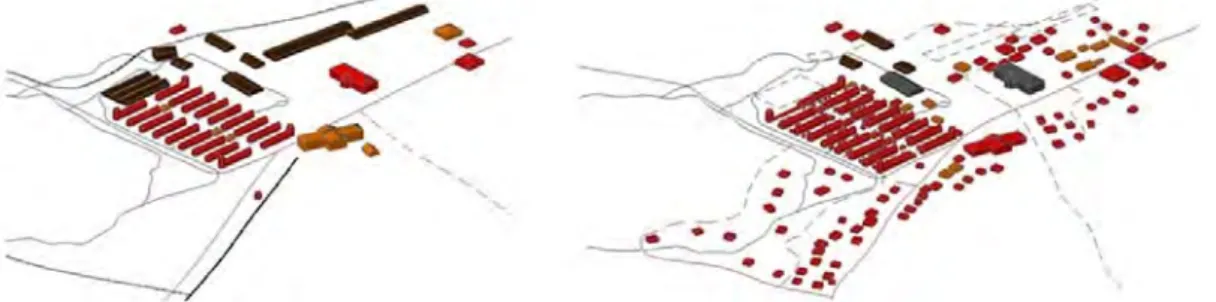
were originally dedicated to agricultural purposes being vacant or adapted to other uses such as housing. Another important aspect, due to the transformation of the social context, is the change of the collective functions (such as communal kitchens) into family-scale uses, causing these facilities to become obsolete (Fernandes, Sá, Póvoas, 2011). Furthermore and in many settlements, common infrastructures (like water or sanitation networks) have been discarded, not only due to the lack of maintenance and ambiguous shared responsibility, but also owing in part to an increasing inadequacy of inherited facilities (Cardoso, 2007). Nonetheless, and even though deriving from a shift in needs and socioeconomic setting, most of these changes have also represented a loss of facilities or capacities essential for basic living conditions, and thus need to be urgently provided.
Figure 4. Diagram of the functions of the buildings in the Roça Boa Entrada, in the beginning of the XXth century and in 2010 – red: housing, brown: production, yellow: services and assistance, grey: vacant [ASF]. A – airport H – hospital M – military headquarters A A C – centre F – fort P – port R – ‘roça’ (estate) R R A – airport H – hospital M – military headquarters C – centre F – fort P – port R – ‘roça’ (estate) H H R M R M P F F C P C R F F R R R
Figure 5. City of São Tomé: constructions in the late
The mutations of the urban environment are also extensive, both in its role and in its morphology. The city of São Tomé has irradiated from the initial bay throughout time, tendency that has been
maintained till nowadays, with the acceleration of the urbanisation process5. The urban areas thus
extend along the coast and the inward roads, forming a dispersed but continuous mass. Nevertheless, and despite this city’s small scale, its expansion hasn’t been accompanied by a similar provision of infrastructures and public space, or by articulation strategies, resulting in a
growth formed by fragments and extensive areas of areas with little conditions6. Public facilities and
outdoor space remain similar from the colonial period, even though the city has expanded greatly, enlarging the gap between a consolidated core and informal fragments awaiting consolidation.
[ASF] [TN]
Figure 7. Diagram representing the urban disparities in São Tomé – brown: informal areas, blue: formal city [ASF, based on GoogleEarth imagery, 2010].
[ASF] [GE] [TN]
Figure 8. Diagram of the urban fragments in São Tomé – brown: informal areas, green: real estate developments [ASF, based on GoogleEarth imagery, 2010].
5 The Report on Human Development of 2002 (UNDP, 2002, free translation) points out that if in 1960 the urban population (of both São Tomé and Santo António) corresponded to 6% of the total numbers, by 1992 it had reached 42% and in 1998 already 48,9%, in a growth that was similar to other African cities.
6 Augusto Nascimento (2008: 61, translation by authors) refers that “the city experiments the difficulties of a growth for which it has no infrastructures”.
Land and property
Another important challenge is related to land tenure and property, and its impact in the organisation of the territory and in the built environment.
On the one hand, the nationalisation and distribution of land established a great impact in the structure of the territory and in the economic production, with the transformation of the large domains of the estates into small subsistence plots. This mutation has not only changed the productive system and the scale of the properties, but specially the relation to the land and its evolution in time: having a strong connection to the family structure, the land is subdivided in each generation, sometimes to such a small scale that even hinders subsistence and obstructs any attempt to articulate or jointly plan a determined area.
On the other hand, it has also changed the investment and the responsibility put in the improvement of the property, and especially of the buildings. In the contexts where land has been nationalised and dwellers possess only their title of use, the sense of insecurity and uncertainty on the future undermines the responsibility and the will to invest in its upgrading. When there are simultaneous relations to land from different agents, each of the stakeholders becomes reluctant in assuming responsibility for any intervention on it, fearing the inability to profit from this effort. Furthermore, economic constraints also restrain the ability of intervention and improvement of the built environment, both by the dwellers and the State, resulting in a progressive and worrying degradation of the existing structures.
Figure 9. Land division in 1961 – white: roças, grey:
(referenced as HMS), PhD student at FAUP with the supervision of Arch. Sérgio Fernandez.
Built heritage
Though the built heritage in São Tomé and Príncipe retains substantial potential, as both a cultural testimony and as architectonic and urbanistic remarkable landmarks (Fernandes, 2005; Mattoso, 2010), most of the inherited buildings and sites present an alarming advanced state of degradation
(Fernandes, Sá, Póvoas, 2011).
The relation of property is one of the aspects that contribute to this severe dilapidation, while another reason is also their creation within specific contexts and socioeconomic structures, facing nowadays the need to adjust to new demands and to the capacities of their users. This misfit between the original demands of the periods in which these inherited structures were built and the contemporary needs, does not apply to this context alone, but constitutes probably one of the characteristics that can be identified in many other postcolonial contexts.
As the study of the processes of initial creation, later adaptation of the space and living dynamics
may shed light into current demands and challenges, the on-going research7 focuses on these
goals. Through the survey of existing structures, their uses, conservation state, constructive detailing and perception of their inhabitants, it aims at establishing a systematization of the adopted solutions in order to contribute to the creation of adequate local support tools of regeneration.
a b c
Figure 11. Example of the built heritage within the estates and their advanced state of degradation, Roça Boa Entrada, São Tomé – (a) main house, (b) warehouse, (c) technicians’ house [ASF+HMS].
c
a b d
Figure 12. Example of on-going architectonic survey, main house, Roça Bombaim, São Tomé – (a) plan of the first floor, (b) plan of the ground floor, (c) front elevation, (d) photograph [ASF+HMS].
Habitação) in charge of the housing policies.
Housing stock
The dwelling panorama represents a very important challenge to the development of São Tomé and Príncipe, where a great proportion of houses lack even the minimum living conditions: in 2001, more than seventy per cent of the total housing stock was considered “basic” (INE, 2003).
Nonetheless, public housing policies to tackle this need are mainly undertaken through social housing, whose property is acquired by their new inhabitants through a rental scheme. As this fixed rent ends up not being accessible to population living beneath the poverty line, the needs of the
poorest rest thus unsolved. This mistargetting is recognised8 as the result of the preferences from
funders, who are more willing to support actions that ensure the refund of the investment and allow future reinvestment and visible replication of the actions. This strategy inverts the priorities of development, favouring the donors’ agenda at the expense of real and urgent needs.
classic basic other collective
Figure 13. Types of dwelling in São Tomé and Príncipe, according to district [INE, 2003].
Figure 14. Example of a recurrent type of wooden house, R. Boa Entrada [ASF].
Social cohesion, sense of common good and neighbourhood
Social bonds constitute the last and ultimate challenge for development, as the improvement of living conditions may also rely on the strength of common initiatives.
The inheritance of a society that was fragmented into several social groups, the colonial regime and the post-independent socialist alignment of the state didn’t contribute to enhancing forms of associability (Nascimento, 2008) nor to building the idea of common asset and public good.
The small-scale of this territory, along with these difficulties in ensuring effective interventions,
contribute to the perpetuation of wealth and poverty cycles (Seibert, 2002).
In some fields of intervention – such as with the commerce or with financing - the formal system often doesn’t provide a comprehensive answer to urgent needs, and informal mechanisms are created to overcome these gaps. This situation, along with many of the aspects previously referred throughout the challenges for development, raise the discussion on the scale of the capacities of the target populations – the most deprived –, realising that sometimes this dimension is hardly understood when policies and intervention mechanisms are created.
Final remarks
The specificity of the postcolonial territories relies in the legacy of past implemented strategies and in the impact that these have established until nowadays. From the colonial projects to the process of rupture undertaken with the independence, these contexts have undergone radical changes in their socioeconomic structures and in their built environment.
The Portuguese colonisation constitutes the longest, and perhaps one of the widest, overseas exploits, with extensive legacy. The colonial project represented an enterprise of enormous proportion, especially for such a small country like Portugal with its few resources, and it was undertaken through different strategies along diverse periods, changing and moulding to the context and to the multiple territories and cultures encountered, in a strategy of miscegenation. São Tomé and Príncipe became a laboratory in which this approach was also pursued: the intense territorial manipulation, the ‘invention of a society’ and their complex interaction throughout time, built an intricate and bittersweet legacy that cannot be generalised nor easily summarised, neither
concerning the land nor the social groups9.
As previously described, present challenges reflect this complex legacy, gathered in a very small territory with few inhabitants. From the shift in the role and economic specialization of this archipelago to the fragmentation of its society, this paper aimed at understanding their impact in the present-day reality and at detecting gaps between needs and policies. The final goal was to present on-going research, while attempting to understand their causes and materialization, in order to contribute to the discussion on operative tools and on the task of planning at different scales. .
9 Dismantling the false idea of a rigid racial distinction and power relation within the society of São Tomé and Príncipe, several authors stress that neither did the settlers always succeed in their enterprise nor did all natives (or new natives) get repressed by the colonial regime (Clarence-Smith, 1989; Nascimento, 2002). Clarence-Smith argues that “(…) it is important to note that, as with land, conflicts largely straddled the racial
‘frontier’. (…) class lines cut across racial ones, and that the black creoles were often allies of the white planters in a struggle which pitted both groups against African peasants.” (1989: 494, 496).
Cardoso, M. (2007) Cabo Verde e S. Tomé e Príncipe. Educação e infra-estruturas como factores
de desenvolvimento (Edições Afrontamento, Lisbon).
Clarence-Smith, W. G. (1989) Creoles and peasants in São Tomé, Príncipe, Fernando Pó and Mount Cameroun, in the Nineteenth Century (Centro de Estudos de História e Cartografia Antiga, Instituto de Investigação Científica e Tropical, Lisbon).
Fernandes, A. S.; Sá, M. F. and Póvoas, R. F. (2011) ‘Património Luso-Afro-Tropical: o exemplo
das Roças de São Tomé e Príncipe. Desafios para a sua conservação e reabilitação, e o seu potencial para o desenvolvimento’. VI Congresso Luso-Moçambicano de Engenharia / III Congresso de Engenharia de Moçambique, J. F. S. Gomes, C. C. António, C. F. Afonso and A. S. Matos (Edições INEGI, Maputo).
Fernandes, J. M. (2005) Arquitectura e Urbanismo na África Portuguesa (Caleidoscópio, Casal de
Cambra).
Frynas, J. G.; Wood, G. and Oliveira, R. M. S. S. (2003) ‘Business and politics in São Tomé e Príncipe: from cocoa monoculture to petro-state’, African Affairs, 102, 51-80 (Oxford University Press, Oxford).
Henriques, I. C. (1989) ‘O ciclo do açúcar em São Tomé e Príncipe nos séculos XV e XVI’, in
Albuquerque, L. (ed.) Portugal no mundo (Publicações Alfa, Lisbon).
Henriques, I. C. (2000) São Tomé e Príncipe: a invenção de uma sociedade (Vega, Lisbon). Hodges, T. and Newitt, M. (1988) São Tomé and Príncipe. From Plantation Colony to Microstate
(Westview Press, London).
INE (2003) ‘Características e Condições da Habitação’, Recenseamento Geral da População e
Habitação de 2001 (Instituto Nacional de Estatística, São Tomé).
INE (2006) São Tomé e Príncipe em números (Instituto Nacional de Estatística, São Tomé).
Lloyd-Jones, S. and Pinto, A. C. - ed. (2003) The last empire: thirty years of Portuguese decolonization (Intellect, Bristol and Portland).
Madeira, T. (1999) ‘Estudo Morfológico da Cidade de São Tomé no Contexto Urbanístico das Cidades Insulares Atlânticas de Origem Portuguesa’, Revista do Centro de Estudos de Urbanismo e Arquitectura, 1.
Madeira, T. (2011) ‘A Cidade de São Tomé’, Conference paper, África. Arquitectura e Urbanismo
de Matriz Portuguesa, 27-28th January 2011 (Universidade Autónoma de Lisboa, Lisbon).
Mattoso, J. – dir. (2010) Património de Origem Portuguesa no Mundo: Arquitectura e Urbanismo, (Fundação Calouste Gulbenkian, Lisbon).
Príncipe Colonial (Instituto Camões - Centro Cultural Português em S. Tomé e Príncipe,
São Tomé).
Nascimento, A. (2008) ‘As ONG em São Tomé e Príncipe: entre a afirmação da sociedade civil e a emulação do clientelismo nas práticas políticas’, CODESRIA: XII General Assembly, Yaoundé, Cameroun.
Nascimento, A. and Cardoso, P. (2008) Atlas da Lusofonia: São Tomé e Príncipe (Prefácio &
Instituto Português da Conjuntura e Estratégia, Lisbon).
Oliveira, J. E. C. (1993) A economia de S. Tomé e Príncipe (Cooperação Portuguesa, Lisbon). Santo, A. C. E. (2009) São Tomé e Príncipe: problemas e perspectivas para o seu
desenvolvimento (Edições Colibri, Lisbon).
Seibert, G. (2002) Camaradas, clientes e compadres: colonialismo, socialismo e democratização em São Tomé e Príncipe (Vega, Lisbon).
Tenreiro, F. (1961) A ilha de São Tomé (Memórias da Junta de Investigações do Ultramar, Lisbon).
UNDP (2002) Rapport National de Développement Humain, São Tomé et Príncipe, 2002 – Changements de 1990 à 2002 et Développement Humain (United Nations Development Programme, São Tomé).
UNDP (2008) Rapport National sur le Développement Humain a São Tomé e Príncipe 2008. La problématique de la terre et le développement humain durable (United Nations Development Programme, São Tomé).
Weszkalnys, G. (2008) ‘Hope & Oil: Expectations in São Tomé e Príncipe’, Review of African
Political Economy, 35: 117, 473-482.
Weszkalnys, G. (2009) ‘The curse of oil in the Gulf of Guinea: a view from São Tomé and Príncipe’, African Affairs, 108/433, 679-689 (Oxford University Press, Oxford).
Iconography and cartography
ASF - Ana Silva Fernandes (first author).
AA.VV. (1646) Planta da Baía de Ana Chaves, Compreende a cidade, a Fortaleza de S. Sebastião
e o Forte do Picão de Nª Senhora da Graça, December 16th, nº 170, Arquivo Histórico Ultramarino,
Lisboa.
CGU-JIU-UM (1961) Carta da Ilha de S. Tomé. Escala 1:75.000. Centro de Geografia do Ultramar, Junta de Investigações do Ultramar, Ministério do Ultramar. Papelaria Fernandes, Lisboa.
HMS - Hugo Machado da Silva, co-author of the architectonic surveys of the Roças of STP.
IGC-JIU-MU (1958) Carta de S. Tomé. Levantamento Aerofotogramétrico. Folha nº 2. Escala 1:25.000. Instituto Geográfico e Cadastral, Junta de Investigações do Ultramar, Ministério do Ultramar, Lisboa.
Instituto Marquês de Valle Flôr e Centro de Estudos em Geografia e Ordenamento do Território da Universidade de Coimbra.
JIU-UM (1962) Carta do Príncipe. Levantamento Aerofotogramétrico. Escala 1:25.000. Junta de Investigações do Ultramar, Ministério do Ultramar, Lisboa.
Leote J R T (1788-1796) Plano da Baia de Ana Chaves, compreendendo a Planta da cidade de S.
Tomé e a perspectiva e planta da Fortaleza de S. Sebastião, 440x670mm, nº176, Arquivo Histórico
Ultramarino, Lisboa.
TN - Téla Non, online newspaper of São Tomé and Príncipe, available at http://www.telanon.info/.
Acknowledgements
This research is being undertaken with the support of a scholarship from
FCT - Fundação para a Ciência e Tecnologia, without which this


![Figure 12. Example of on-going architectonic survey, main house, Roça Bombaim, São Tomé – (a) plan of the first floor, (b) plan of the ground floor, (c) front elevation, (d) photograph [ASF+HMS]](https://thumb-eu.123doks.com/thumbv2/123dok_br/18198457.875900/12.892.157.752.818.1063/figure-example-architectonic-survey-roça-bombaim-elevation-photograph.webp)
![Figure 13. Types of dwelling in São Tomé and Príncipe, according to district [INE, 2003]](https://thumb-eu.123doks.com/thumbv2/123dok_br/18198457.875900/13.892.147.747.469.778/figure-types-dwelling-são-tomé-príncipe-according-district.webp)